The Embudo Fault between Pilar and Arroyo Hondo, New Mexico ...
The Embudo Fault between Pilar and Arroyo Hondo, New Mexico ...
The Embudo Fault between Pilar and Arroyo Hondo, New Mexico ...

Create successful ePaper yourself
Turn your PDF publications into a flip-book with our unique Google optimized e-Paper software.
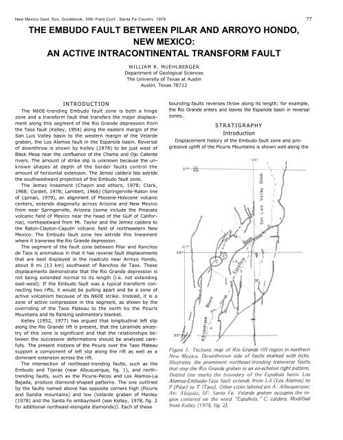
<strong>New</strong> <strong>Mexico</strong> Geol. Soc. Guidebook, 30th Field Conf., Santa Fe Country, 1979 77THE EMBUDO FAULT BETWEEN PILAR AND ARROYO HONDO,NEW MEXICO:AN ACTIVE INTRACONTINENTAL TRANSFORM FAULTWILLIAM R. MUEHLBERGERDepartment of Geological Sciences<strong>The</strong> University of Texas at AustinAustin, Texas 78712INTRODUCT ION<strong>The</strong> N60E-trending <strong>Embudo</strong> fault zone is both a hingezone <strong>and</strong> a transform fault that transfers the major displacementalong this segment of the Rio Gr<strong>and</strong>e depression fromthe Taos fault (Kelley, 1954) along the eastern margin of theSan Luis Valley basin to the western margin of the Velardegraben, the Los Alamos fault in the Espanola basin. Reversalof downthrow is shown by Kelley (1978) to be just west ofBlack Mesa near the confluence of the Chama <strong>and</strong> Ojo Calienterivers. <strong>The</strong> amount of strike slip is unknown because the unknownshapes at depth of the border faults control theamount of horizontal extension. <strong>The</strong> Jemez caldera lies astridethe southwestward projection of the <strong>Embudo</strong> fault zone.<strong>The</strong> Jemez lineament (Chapin <strong>and</strong> others, 1978; Clark,1968; Cordell, 1978; Lambert, 1966) (Springerville-Raton lineof Lipman, 1979), an alignment of Pliocene-Holocene volcaniccenters, extends diagonally across Arizona <strong>and</strong> <strong>New</strong> <strong>Mexico</strong>from near Springerville, Arizona (some include the Pinacatevolcanic field of <strong>Mexico</strong> near the head of the Gulf of California),northeastward from Mt. Taylor <strong>and</strong> the Jemez caldera tothe Raton-Clayton-Capulin volcanic field of northeastern <strong>New</strong><strong>Mexico</strong>. <strong>The</strong> <strong>Embudo</strong> fault zone lies astride this lineamentwhere it traverses the Rio Gr<strong>and</strong>e depression.<strong>The</strong> segment of the fault zone <strong>between</strong> <strong>Pilar</strong> <strong>and</strong> Ranchosde Taos is anomalous in that it has reverse fault displacementsthat are best displayed in the roadcuts near <strong>Arroyo</strong> <strong>Hondo</strong>,about 8 mi (13 km) southwest of Ranchos de Taos. <strong>The</strong>sedisplacements demonstrate that the Rio Gr<strong>and</strong>e depression isnot being extended normal to its length (i.e. not extendingeast-west). If the <strong>Embudo</strong> fault was a typical transform connectingtwo rifts, it would be pulling apart <strong>and</strong> be a zone ofactive volcanism because of its N60E strike. Instead, it is azone of active compression in this segment, as shown by theoverriding of the Taos Plateau to the north by the PicurisMountains <strong>and</strong> its flanking sedimentary blanket.Kelley (1952, 1977) has argued that longitudinal left slipalong the Rio Gr<strong>and</strong>e rift is present, that the Laramide ancestryof this zone is significant <strong>and</strong> that the relationships <strong>between</strong>the successive deformations should be analyzed carefully.<strong>The</strong> present motions of the Picuris over the Taos Plateausupport a component of left slip along the rift as well as adominant extension across the rift.<strong>The</strong> intersection of northeast-trending faults, such as the<strong>Embudo</strong> <strong>and</strong> Tijeras (near Albuquerque, fig. 1), <strong>and</strong> northtrendingfaults, such as the Picuris-Pecos <strong>and</strong> Los Alamos-LaBajada, produce diamond-shaped patterns. <strong>The</strong> one outlinedby the faults named above has opposite corners high (Picuris<strong>and</strong> S<strong>and</strong>ia mountains) <strong>and</strong> low (Velarde graben of Manley(1978) <strong>and</strong> the Santa Fe embayment (see Kelley, 1978, fig. 2for additional northeast-elongate diamonds)). Each of thesebounding faults reverses throw along its length; for example,the Rio Gr<strong>and</strong>e enters <strong>and</strong> leaves the Espanola basin in reversalzones.S T R A T I G R A P H YIntroductionDisplacement history of the <strong>Embudo</strong> fault zone <strong>and</strong> progressiveuplift of the Picuris Mountains is shown well along the
78 MUEHLBERGER<strong>Pilar</strong>-<strong>Arroyo</strong> <strong>Hondo</strong> segment (fig. 2). Only those units exposedin the wedge-shaped segment bounded by the Rio Gr<strong>and</strong>e,<strong>Arroyo</strong> <strong>Hondo</strong> <strong>and</strong> <strong>New</strong> <strong>Mexico</strong> Highway 68 will be describedin this paper, which is an updating of work I reported inHawley (1978, p. 41-46). <strong>The</strong> Picuris Tuff, exposed along thebase of the Picuris Mountains east of <strong>Arroyo</strong> <strong>Hondo</strong>, underliesthe units to be described <strong>and</strong> apparently predates the uplift ofthe Picuris Mountains. If the Picuris Tuff is a correlative of theAbiquiu Tuff, as is usually presumed, then it is part of thealluvial blanket that marks the initial faulting along the easternmargin of the San Luis Valley basin (Lipman <strong>and</strong> Mehnert,1975) about 26 m.y. ago. Virtually no depositional-systemsanalysis has been attempted for the Picuris Tuff in this region.Its fragmented outcrop pattern presents a challenge to thegeologist for interpretation <strong>and</strong> synthesis. A successful analysiswill help delineate the relative displacements <strong>between</strong> blocksin this complicated structural corner among the Picuris Mountains,Taos Plateau <strong>and</strong> Sangre de Cristo Mountains.Four distinctive units are mappable in the <strong>Pilar</strong>-<strong>Arroyo</strong><strong>Hondo</strong> area (fig. 3). <strong>The</strong>se are given letter designations on theillustrations; their correlations are given in the text <strong>and</strong> figurecaptions.All but the oldest contain material derived from the PicurisMountains. In general, the sequence coarsens upward, suggestingan increase in topographic relief. <strong>The</strong> coarseness of theyoungest bouldery terrace gravels (younger than any of themapped units), however, is probably the result of climaticchanges (glacial epochs according to Miller, in Miller <strong>and</strong>others, 1963).Units A <strong>and</strong> B (Chama-el rito Member (?) ofTesuque Formation)Best exposure of these units is in roadcut 2 (fig. 4). <strong>The</strong>yconsist of fluvial deposits composed of fining-upward sequencesof conglomerate, volcanic arenite <strong>and</strong> mudstone. Sedimentarycurrent features show a generally southerly transportdirection. No clasts are derived from the adjacent PicurisMountains, but instead are dominated by a variety of roundedto subrounded volcanic types, with lesser quantities of graniticrocks, <strong>and</strong> a minor amount of gray limestone.Unit A, the older, is finer grained <strong>and</strong> less cemented thanUnit B, <strong>and</strong> consists of yellowish-buff s<strong>and</strong>stone layers alter-
EMBUDO FAULT BETWEEN PI LAR AND ARROYO HONDO 79interpreted to be s<strong>and</strong>-dune, playa-type lacustrine <strong>and</strong> alluvialf<strong>and</strong>eposits.<strong>The</strong> s<strong>and</strong>-dune facies consists of buff s<strong>and</strong> in large crossbeddedunits with an easterly paleo-wind direction. <strong>The</strong>se bedsare identical to the typical Ojo Caliente S<strong>and</strong>stone exposed 15mi (24 km) to the west along the Ojo Caliente River. <strong>The</strong>intervening strip is covered by basalts of Black Mesa <strong>and</strong> itsflanking l<strong>and</strong>slide apron so that direct correlation is impossible.<strong>The</strong> playa-type lacustrine facies consists of brownish silt <strong>and</strong>s<strong>and</strong> that is parallel-bedded (vertically accreted windblowns<strong>and</strong>) <strong>and</strong> which contains small carbonate nodules <strong>and</strong> fossilsoil zones.<strong>The</strong> alluvial-fan facies forms ribbed outcrops <strong>and</strong> consists ofgray pebbly gravel that is subangular to subrounded. All clastsare schist <strong>and</strong> quartzite derived from the Precambrian rocksexposed immediately to the south in the Picuris Mountains.<strong>The</strong> gray color is due to the abundance of s<strong>and</strong> <strong>and</strong> smallpebble-sized fragments of black slate <strong>and</strong> phyllite. Placers ofgarnet crystals also are present. <strong>The</strong> average size of the conglomerateclasts is slightly larger in the higher exposed layers.Total exposed section is estimated to be about 1500 ft (460m) thick. <strong>The</strong> base is not exposed <strong>and</strong> the top is an angularunconformity under the Servilleta Formation (Unit D).nating with bluish-gray pebbly s<strong>and</strong>stone. Unit B is dominatedby gravelly s<strong>and</strong>s that have gray or reddish matrices separatedby meter-thick red mudstones. In both units, the gravellylayers are cemented better <strong>and</strong> tend to hold up low ridges. <strong>The</strong>generally uncemented, easily eroded nature of these units isshown by the wide amphitheater (fig. 3) that is eroded intothese units as compared with the usual narrow V-shapedcanyon of <strong>Arroyo</strong> <strong>Hondo</strong>. <strong>The</strong>se units have been recognizedonly in <strong>Arroyo</strong> <strong>Hondo</strong> <strong>and</strong> in the unnamed arroyo immediatelyto the east.Unit C (Ojo Caliente S<strong>and</strong>stone Member of theTesuque Formation)This unit is exposed well on the southward-facing bluffs ofRito Cieneguilla from <strong>Pilar</strong> northeastward. <strong>New</strong> <strong>Mexico</strong> Highway68 parallels this Rito <strong>and</strong> its roadcuts provide many convenientexposures until it tops out on the Taos Plateau. <strong>The</strong>oldest exposed part of Unit C is in the bluffs near <strong>Pilar</strong>, <strong>and</strong>because of consistent west to north dips, progressively youngerbeds are traversed northeastward along Highway 68 until itpasses out of Rito Cieneguilla <strong>and</strong> onto the Taos Plateau.Unit C consists of three distinctive facies that are interbeddedin units 40 to 50 ft (12 to 15 m) thick, <strong>and</strong> which areUnit D (Servilleta Formation)This unit will be described in three segments, in stratigraphicorder from oldest to youngest: the conglomeratesnorth of the <strong>Embudo</strong> fault scarp along the Rio Gr<strong>and</strong>e, theiroverlying basalts, <strong>and</strong> the single basalt <strong>and</strong> associated conglomeratessouth of the <strong>Embudo</strong> fault scarp.<strong>The</strong> canyon of the Rio Gr<strong>and</strong>e north of <strong>Pilar</strong> is carved intothe Servilleta Formation. Near <strong>Pilar</strong>, extensive l<strong>and</strong>slide covermasks the underlying sedimentary rocks except for those bedsimmediately underlying the capping basalts <strong>and</strong> exposures incanyons on the east wall 2.5 mi (4 km) north of <strong>Pilar</strong>. Here,about 500 ft (150 m) of gray pebble-cobble conglomerate thatis subrounded to subangular <strong>and</strong> which coarsens upward areexposed in a steep-walled arroyo. All clasts are of rock typesexposed in the Picuris Mountains to the southeast. Pebble imbrication<strong>and</strong> crossbed transport directions lie in the northwestquadrant. None of the units is of mudflow origin, but insteadis characteristic of braided-stream alluvial-fan types. Presumably,these lie on the Santa Fe Group, but if present aboveriver level, they are covered. <strong>The</strong> widening of the canyon inthis reach might be a result of erosion through the lightlycemented Servilleta sedimentary rocks into the eolian s<strong>and</strong>facies of the Ojo Caliente Member of the Tesuque Formation.<strong>The</strong>se beds dip only a few degrees north <strong>and</strong> west (initial dip?)<strong>and</strong> appear to underlie conformably the capping basalts of theRio Gr<strong>and</strong>e Canyon.<strong>The</strong> basalts exposed along the Rio Gr<strong>and</strong>e Gorge are in distinctpackages of 3-5 flows each separated by sedimentaryinterbeds of varying thickness. <strong>The</strong> lowest exposed basaltpackage terminates a few kilometers north of the confluenceof the Rio Pueblo de Taos <strong>and</strong> the Rio Gr<strong>and</strong>e; the visibleresult is the change in shape of the gorge from a steep V-shaped canyon southward to the wider slump-block-coated U-shaped canyon. Continuing southward, successively higherbasalt packages step farther southward over the northward-
80 MUEHLBERGERbuilding Servilleta alluvial fans until, from <strong>Pilar</strong> onward, onlythe top package continues the length of Black Mesa nearly toEspanola. <strong>The</strong> lowest basalt of each package from Rio Pueblode Taos south nearly to <strong>Pilar</strong> is commonly partially altered toa greenish color. (Kono <strong>and</strong> others (1967) ascribed this to amontmorillonite clay from their samples in the Rio Pueblo deTaos.) This consistent relationship <strong>and</strong> the presence locally ofsoft-sediment deformation suggest that a playa or alluvial flatdeveloped <strong>between</strong> the northward-prograding alluvial fansfrom the rising Picuris Mountains <strong>and</strong> the southward-movingbasalt flows.<strong>The</strong>se olivine-tholeiites (Aoki, 1967) range in age from 4.5to 3.62 m.y. (Ozima <strong>and</strong> others, 1967). Manley (1976) reportedan age of 2.8 m.y. for the basalt capping Black Mesanear Espanola. This latter basalt appears to overlie the youngestpackage of the Rio Gr<strong>and</strong>e Gorge basalt <strong>and</strong> does not carryalong the mesa cap to <strong>Pilar</strong>. Instead, it appears to stay on thewest side of the mesa <strong>and</strong> continue north toward CerroMojino. Lipman (1978, p. 40) located the largest exposedsources of Servilleta basalts as two very-low-angle shield volcanoesa few kilometers east of Tres Piedras (30 mi (48 km)northwest of Taos, near the western edge of the Taos Plateau).South of the <strong>Embudo</strong> fault, a single discontinuous basaltcaps the mesa northeast of <strong>Pilar</strong>. A thin conglomerate at itsbase rests with angular unconformity across the Ojo CalienteMember of the Tesuque Formation. <strong>The</strong> basalt <strong>and</strong> underlyingconglomerate are thickest in the bluffs above <strong>Pilar</strong> where eachis nearly 40 ft (12 m) thick. Farther northeast, the basalt<strong>and</strong>/or the underlying conglomerate together are 20 ft (6 m)or less in thickness <strong>and</strong> are locally absent. Bent pipe vesicles donot give consistent flow directions (west near <strong>Pilar</strong> <strong>and</strong> southeasta mile farther east). Whether this flow correlates with thetop basalt or any of the four basalts that are exposed north ofthe <strong>Embudo</strong> fault along the mesa northeast of <strong>Pilar</strong> is unknown.<strong>The</strong>re are no identifiable differences in h<strong>and</strong> specimen.(Aoki (1967) remarked on the uniformity of these basaltsalong the Rio Gr<strong>and</strong>e Gorge to the north.)<strong>The</strong> youngest part of the Servilleta Formation in this area isextremely coarse <strong>and</strong> overlies the basalts of the Rio Gr<strong>and</strong>eGorge. <strong>The</strong> formation includes the alluvial-fan deposits of<strong>Arroyo</strong> <strong>Hondo</strong> deposited prior to the entrenching of <strong>Arroyo</strong><strong>Hondo</strong> in response to the active downcutting of the RioGr<strong>and</strong>e. Angular cobble- to boulder-sized clasts of phyllite,schist <strong>and</strong> quartzite litter the surface of the fan deposit. Remnantsof fan deposits overlie the basalt member of the ServilletaFormation, <strong>and</strong> in places, beheaded channels are presenton the mesa extending northeast from <strong>Pilar</strong>.<strong>The</strong> headward growth of Rito Cieneguilla <strong>and</strong> its majortributaries (Agua Caliente <strong>and</strong> Piedra Lumbre) gradually abstracted<strong>and</strong> diverted all drainages from the Picuris Mountainsthat crossed the <strong>Embudo</strong> fault; as a result, these drainagesbecame parallel to it to join the Rio Gr<strong>and</strong>e at <strong>Pilar</strong>. <strong>The</strong>numerous gravel deposits of this dissection have not beenstudied yet to determine whether they have structural as wellas climatic controls.EMBUDO FAULT<strong>The</strong> stratigraphic data presented in the previous sectionshow that erosion of Precambrian rocks from the PicurisMountains had begun already in late Santa Fe time (Ojo CalienteS<strong>and</strong>stone Member) or over 7 m.y. ago during the lateMiocene (using Manley's (1978) correlation chart). Thus, the<strong>Embudo</strong> fault was in existence by this time. Whether it wasactive earlier is not known, although the presence of PicurisTuff <strong>and</strong> its northward correlative, the Los Pinos Formation,which Lipman <strong>and</strong> Mehnert (1975) state marks the inceptionof Rio Gr<strong>and</strong>e rifting in southern Colorado, suggests that thisregion was subsiding, <strong>and</strong> that the <strong>Embudo</strong> fault was notactive or is at least unrecognized.<strong>The</strong> coarsening upward of Picuris-derived clasts indicatesthat the topographic relief <strong>between</strong> the San Luis Valley basin<strong>and</strong> the Picuris Mountains across the <strong>Embudo</strong> fault has beenincreasing. Using gravity data, Cordell (1976) postulates thatPrecambrian basement is at sea level a few kilometers north of<strong>Pilar</strong>. In contrast, the Picuris Mountains reach upward to10,810 ft (3,300 m) a few kilometers east of <strong>Pilar</strong>. Thus, structuralrelief across the fault zone is at least 10,000 ft (3,000 m),depending on the amount of eastward dip of the basement toTaos.<strong>The</strong> <strong>Embudo</strong> fault, as used here, is that fault which has amappable surface trace from <strong>Pilar</strong> northeast to <strong>Hondo</strong> Canyon.It also is visible for several kilometers southwest of <strong>Pilar</strong> as alinear groove that cuts the feet of the massive l<strong>and</strong>slides thatflank the Rio Gr<strong>and</strong>e. East of <strong>Hondo</strong> Canyon, the fault scarploses its sharp definition as it turns eastward so that onlydiscontinuous segments can be found <strong>and</strong> elsewhere it appearsto be masked by l<strong>and</strong>sliding.Microfaulted s<strong>and</strong>-dune facies of Unit D is displayed well inthe roadcuts for one-half mile (.8 km) southwest of where theroad reaches the Taos Plateau. Contradictory fault slip solutionshave been obtained using observed separations on bed set<strong>and</strong> crossbed set boundaries. Assuming that they formed afterthe beds had been rotated to their present attitudes, mostfaults striking north to west <strong>and</strong> dipping southwest (averaging45 ° ) show reverse-slip solutions, <strong>and</strong> steeply dipping faultsthat strike northeast show left strike-slip. Why some faults donot fit these patterns has yet to be resolved but may relate tothe timing of this microfaulting, <strong>and</strong> the uplift <strong>and</strong> tilting ofthe entire unit.<strong>The</strong> linearity of Rio Pueblo Taos suggests fault control, althoughit may be only a synclinal downwarp parallel to thegorge arch (fig. 2). <strong>The</strong> streams draining into the Rio Pueblode Taos have asymmetrical shapes with the steep slope on theeast, suggesting an eastward-tilting of this region as far as Taos.<strong>The</strong> northeastward projection of the gorge arch across <strong>New</strong><strong>Mexico</strong> Highway 3 to the mouth of the Rio <strong>Hondo</strong> marks theprominent drainage divide of streams draining west to the RioGr<strong>and</strong>e from streams draining south to the Rio Pueblo deTaos. <strong>The</strong> western boundary of this warped block appears tobe the down-to-the-east faults <strong>and</strong> monoclines that parallel theRio Gr<strong>and</strong>e from west of the village of <strong>Arroyo</strong> <strong>Hondo</strong> (trellisdrainage west of <strong>Arroyo</strong> <strong>Hondo</strong> (fig. 2)) south nearly to <strong>Pilar</strong>.<strong>The</strong> eastern boundary is marked by prominent piedmontscarps along the Sangre de Cristo range front. <strong>The</strong> range frontturns southwest to join the <strong>Embudo</strong> fault zone. <strong>The</strong> northtrendingfaulting <strong>between</strong> the Picuris-Pecos fault <strong>and</strong> thatacross Rio Gr<strong>and</strong>e del Rancho includes a variety of motions,most of which have yet to be sorted out. This area currently isbeing studied in detail as part of our program to unravel thedepositional <strong>and</strong> structural history of this region.<strong>The</strong> presence of basalt inliers at the surface of the piedmontslope from <strong>Hondo</strong> Canyon (fig. 5) east suggests that unidentifiedfaults underlie this surface <strong>and</strong> may aid in controlling thecourse of the Rio Pueblo de Taos immediately to the north.
Lambert (1966) first described the north-trending set ofdown-to-the-west faults that traverse Rio Pueblo de Taos westof Taos. He pointed out that they are in line with the northernprojection of the Pecos-Picuris fault, the major regional faulton which several periods of slip can be demonstrated (Miller<strong>and</strong> others, 1963).<strong>The</strong> fact that the <strong>Embudo</strong> fault shows reverse motions alongits roadcut exposures in <strong>Hondo</strong> Canyon suggests that it mayhave upthrust geometry throughout the segment east of <strong>Pilar</strong>.<strong>The</strong> reversal of throw southwest of <strong>Pilar</strong> shows its scissormotion that appears to have its pivot on the Precambrian highthat separates the Espanola from the San Luis Valley basins(marked by Cerro Azul) (Cordell, 1976; Kelley, 1978). Becausethis fault acts like a transform fault (it connects two riftsegments), there must be a significant but as yet undemonstratedstrike-slip component. <strong>The</strong> size of the strike-slip componentis a function of the three-dimensional shape of the riftbasin, a shape that is known poorly (at best). Whether thefaults are planar or listric also makes significant differences inestimates of extension. <strong>The</strong> consistent tilt of the basin-fillingunits toward the Sangre de Cristo Mountains implies a listricshape to the border fault.<strong>The</strong> reverse component has major regional significance because,if rifting was extending perpendicularly to the length ofthe rift, then this fault would be an oblique pull-apart fault, aleaky transform. Instead, it is the opposite, which suggests thatthe diamond-shaped block that has the Picuris <strong>and</strong> S<strong>and</strong>iamountains at the opposite narrow ends is being shortenedacross this long diagonal (rotated counterclockwise). Thissupports Kelley's (1977) feeling that there must be a left-slipcomponent parallel to the rift. <strong>The</strong> <strong>Embudo</strong> fault data supporta left-slip component along the rift.ADDENDUMI received the volume by Riecker (1979) as this manuscriptwas being typed. In it are summaries by Kelley (tectonics,middle Rio Gr<strong>and</strong>e rift), Lipman <strong>and</strong> Mehnert (Taos Plateauvolcanic field) <strong>and</strong> Manley (Espanola basin) that represent themost recent statements by these workers. Kelley shows thatthe right en-echelon offset of basins involves ramping down-tothe-northof uplifts arranged in relay <strong>and</strong> that this processrequires a left-slip component along the north-trending faults.Lipman <strong>and</strong> Mehnert redefine the Servilleta Formation (thispaper adopted the usage of Lambert (1966)) to be only thetholeiitic basalts. <strong>The</strong>y state that the interbedded sedimentaryrocks have the same names as laterally equivalent units such asthe Ancha Formation to the south (Manley, 1978), <strong>and</strong> thatoverlying sedimentary rocks are of an unrelated lithology <strong>and</strong>genesis, being mainly Pleistocene glacial outwash fans. Manleyrenames several of Kelley's (1952) faults <strong>and</strong> defines the
82 MUEHLBERGERVelarde graben. <strong>The</strong> graben extends southwest from near <strong>Pilar</strong>(my interpretation), where the Rio Gr<strong>and</strong>e enters thestructure, to where the river turns south; here, the grabenwidens <strong>and</strong> the border faults also turn south. <strong>The</strong> westernborder is the Pajarito fault zone (Los Alamos fault of Kelley)<strong>and</strong> the eastern border is an unnamed zone trending throughPojoaque.<strong>The</strong> narrow northeast-trending segment of the graben is the<strong>Embudo</strong> fault of Kelley. <strong>The</strong> northeastern segment of thesouthern border fault, the Velarde fault of Manley, is the faultdiscussed in this paper that I have called the <strong>Embudo</strong> fault.<strong>The</strong> Velarde graben is a sub-basin of the Espanola basin that isthe currently active down-dropping segment of the basin. <strong>The</strong>Velarde (<strong>Embudo</strong>) fault is part of the transform zone <strong>between</strong>the Velarde graben <strong>and</strong> the San Luis Valley basin. <strong>The</strong> rotation<strong>and</strong> hinge action of this fault is shown by the change from along narrow northeast-trending graben northeastward to areverse <strong>and</strong> upthrust style of faulting where it bounds thesouthern end of the currently active subsiding block of theTaos reentrant.ACKNOWLEDGMENTSI wish to thank the following agencies: for time: researchleave funded by the Graduate School, <strong>The</strong> University of Texasat Austin; for travel funds: the Geology Foundation, <strong>The</strong> Universityof Texas at Austin; for research facilities: Ft. BurgwinResearch Center, Southern Methodist University at Taos, <strong>New</strong><strong>Mexico</strong>; for advice: students <strong>and</strong> faculty involved in our summerfield geology program, 1977-1978.REFERENCESAoki, K, 1967, Petrography <strong>and</strong> petrochemistry of latest Plioceneolivine-tholeiites of Taos area, northern <strong>New</strong> <strong>Mexico</strong>, U.S.A.: Contributionsto Mineralogy <strong>and</strong> Petrology, v. 14, p. 190-203.Chapin, C. E., Chamberlin, R. M., Osburn, G. R., White, D. W. <strong>and</strong>Sanford, A. R., 1978, Exploration framework of the Socorro geo -thermal area, <strong>New</strong> <strong>Mexico</strong>: <strong>New</strong> <strong>Mexico</strong> Geological Society SpecialPublication 7, p. 115-129.Clark, K. F., 1968, Structural control in the Red River District, <strong>New</strong><strong>Mexico</strong>: Economic Geology, v. 63, p. 553-566.Cordell, L., 1976, Aeromagnetic <strong>and</strong> gravity studies of the Rio Gr<strong>and</strong>egraben in <strong>New</strong> <strong>Mexico</strong> <strong>between</strong> Belen <strong>and</strong> <strong>Pilar</strong>: <strong>New</strong> <strong>Mexico</strong> Geo -logical Society Special Publication 6, p. 62-70.----, 1978, Regional geophysical setting of the Rio Gr<strong>and</strong>e rift:Geological Society of America Bulletin, v. 89, p. 1073-1090.Hawley, J. W., compiler, 1978, Guidebook to Rio Gr<strong>and</strong>e rift in <strong>New</strong><strong>Mexico</strong> <strong>and</strong> Colorado: <strong>New</strong> <strong>Mexico</strong> Bureau of Mines <strong>and</strong> MineralResources Circular 163, 241 p.Kelley, V. C., 1952, Tectonics of the Rio Gr<strong>and</strong>e depression of centralNe w <strong>Mexico</strong>: <strong>New</strong> M exi co G eol ogic al So ciety Guid ebook 3, p .92-105.----, 1954, Tectonic map of a part of the upper Rio Gr<strong>and</strong>e area,<strong>New</strong> <strong>Mexico</strong>: U.S. Geological Survey Oil <strong>and</strong> Gas Investigations MapOM-157.----, 1977, Geology of the Albuquerque Basin, <strong>New</strong> <strong>Mexico</strong>: <strong>New</strong><strong>Mexico</strong> Bureau of Mines <strong>and</strong> Mineral Resources Memoir 33, 60 p.----, 1978, Geology of Espanola Basin, <strong>New</strong> <strong>Mexico</strong>: <strong>New</strong> <strong>Mexico</strong>Bureau of Mines <strong>and</strong> Mineral Resources Geologic Map 48.Kono, M., Kobayashi, K., Ozima, M., Kinoshita, H., Nagata, T., Larson,E. E. <strong>and</strong> Strangway, D., 1967, Paleomagnetism of Pliocene basaltsfrom the southwestern U.S.A.: Journal of Geomagnetism <strong>and</strong> Geoelectricity,v. 19, p. 357-375.Lambert, W., 1966, Notes on the late Cenozoic geology of the Taos-Questa area, <strong>New</strong> <strong>Mexico</strong>: <strong>New</strong> <strong>Mexico</strong> Geological Society Guide -book 17, p. 43-50.Lipman, P. W., 1978, Roadlog, Antonito, Colorado to Rio Gr<strong>and</strong>eGorge, <strong>New</strong> <strong>Mexico</strong>: <strong>New</strong> <strong>Mexico</strong> Bureau of Mines <strong>and</strong> Mineral ResourcesCircular 163, p. 36-42.----, 1979, Cenozoic volcanism in the western United States: implicationsfor continental tectonics, in Burchfiel, B. C., Oliver, J. E.<strong>and</strong> Silver, L. T., eds., Continental Tectonics, Studies in Geophysics:Geophysics Research Board, National Academy of Sciences, in press.Lipman, P. W. <strong>and</strong> Mehnert, H. H., 1975, Late Cenozoic basaltic volcanism<strong>and</strong> development of the Rio Gr<strong>and</strong>e depression in the southernRocky Mountains: Geological Society of America Memoir 144,p. 119-154.Manley, K., 1976, K-Ar age determinations on Pliocene basalts from theEspanola Basin, <strong>New</strong> <strong>Mexico</strong>: Isochron/West, n. 16, p. 29-30.----, 1978, Structure <strong>and</strong> stratigraphy of the Espanola Basin, RioGr<strong>and</strong>e rift, <strong>New</strong> <strong>Mexico</strong>: U.S. Geological Survey Open-File Report78-667, 24 p.Miller, J. P., Montgomery, A. <strong>and</strong> Sutherl<strong>and</strong>, P. K., 1963, Geology ofpart of the southern Sangre de Cristo Mountains, <strong>New</strong> <strong>Mexico</strong>: <strong>New</strong><strong>Mexico</strong> Bureau of Mines <strong>and</strong> Mineral Resources Memoir 11, 106 p.Ozima, M., Kono, M., Kaneoka, I., Kinoshita, H., Kobayashi, K.,Nagata, H., Larson, E. E. <strong>and</strong> Strangway, D., 1967, Paleomagnetism<strong>and</strong> potassium-argon ages of some volcanic rocks from the RioGr<strong>and</strong>e Gorge, <strong>New</strong> <strong>Mexico</strong>: Journal of Geophysical Research, v. 72,p. 2615-2621.Riecker, R. E., ed., 1979, Rio Gr<strong>and</strong>e rift: tectonics <strong>and</strong> magmatism:American Geophysical Union, Washington, 438 p.