The Embudo Fault between Pilar and Arroyo Hondo, New Mexico ...
The Embudo Fault between Pilar and Arroyo Hondo, New Mexico ...
The Embudo Fault between Pilar and Arroyo Hondo, New Mexico ...

You also want an ePaper? Increase the reach of your titles
YUMPU automatically turns print PDFs into web optimized ePapers that Google loves.
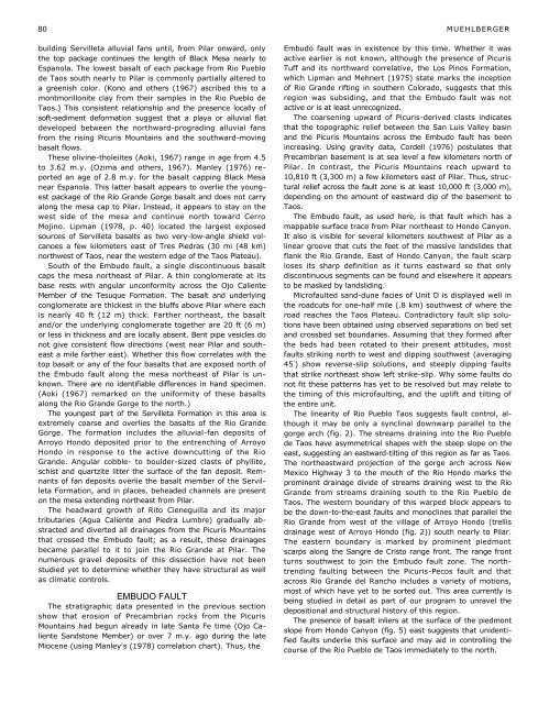
80 MUEHLBERGERbuilding Servilleta alluvial fans until, from <strong>Pilar</strong> onward, onlythe top package continues the length of Black Mesa nearly toEspanola. <strong>The</strong> lowest basalt of each package from Rio Pueblode Taos south nearly to <strong>Pilar</strong> is commonly partially altered toa greenish color. (Kono <strong>and</strong> others (1967) ascribed this to amontmorillonite clay from their samples in the Rio Pueblo deTaos.) This consistent relationship <strong>and</strong> the presence locally ofsoft-sediment deformation suggest that a playa or alluvial flatdeveloped <strong>between</strong> the northward-prograding alluvial fansfrom the rising Picuris Mountains <strong>and</strong> the southward-movingbasalt flows.<strong>The</strong>se olivine-tholeiites (Aoki, 1967) range in age from 4.5to 3.62 m.y. (Ozima <strong>and</strong> others, 1967). Manley (1976) reportedan age of 2.8 m.y. for the basalt capping Black Mesanear Espanola. This latter basalt appears to overlie the youngestpackage of the Rio Gr<strong>and</strong>e Gorge basalt <strong>and</strong> does not carryalong the mesa cap to <strong>Pilar</strong>. Instead, it appears to stay on thewest side of the mesa <strong>and</strong> continue north toward CerroMojino. Lipman (1978, p. 40) located the largest exposedsources of Servilleta basalts as two very-low-angle shield volcanoesa few kilometers east of Tres Piedras (30 mi (48 km)northwest of Taos, near the western edge of the Taos Plateau).South of the <strong>Embudo</strong> fault, a single discontinuous basaltcaps the mesa northeast of <strong>Pilar</strong>. A thin conglomerate at itsbase rests with angular unconformity across the Ojo CalienteMember of the Tesuque Formation. <strong>The</strong> basalt <strong>and</strong> underlyingconglomerate are thickest in the bluffs above <strong>Pilar</strong> where eachis nearly 40 ft (12 m) thick. Farther northeast, the basalt<strong>and</strong>/or the underlying conglomerate together are 20 ft (6 m)or less in thickness <strong>and</strong> are locally absent. Bent pipe vesicles donot give consistent flow directions (west near <strong>Pilar</strong> <strong>and</strong> southeasta mile farther east). Whether this flow correlates with thetop basalt or any of the four basalts that are exposed north ofthe <strong>Embudo</strong> fault along the mesa northeast of <strong>Pilar</strong> is unknown.<strong>The</strong>re are no identifiable differences in h<strong>and</strong> specimen.(Aoki (1967) remarked on the uniformity of these basaltsalong the Rio Gr<strong>and</strong>e Gorge to the north.)<strong>The</strong> youngest part of the Servilleta Formation in this area isextremely coarse <strong>and</strong> overlies the basalts of the Rio Gr<strong>and</strong>eGorge. <strong>The</strong> formation includes the alluvial-fan deposits of<strong>Arroyo</strong> <strong>Hondo</strong> deposited prior to the entrenching of <strong>Arroyo</strong><strong>Hondo</strong> in response to the active downcutting of the RioGr<strong>and</strong>e. Angular cobble- to boulder-sized clasts of phyllite,schist <strong>and</strong> quartzite litter the surface of the fan deposit. Remnantsof fan deposits overlie the basalt member of the ServilletaFormation, <strong>and</strong> in places, beheaded channels are presenton the mesa extending northeast from <strong>Pilar</strong>.<strong>The</strong> headward growth of Rito Cieneguilla <strong>and</strong> its majortributaries (Agua Caliente <strong>and</strong> Piedra Lumbre) gradually abstracted<strong>and</strong> diverted all drainages from the Picuris Mountainsthat crossed the <strong>Embudo</strong> fault; as a result, these drainagesbecame parallel to it to join the Rio Gr<strong>and</strong>e at <strong>Pilar</strong>. <strong>The</strong>numerous gravel deposits of this dissection have not beenstudied yet to determine whether they have structural as wellas climatic controls.EMBUDO FAULT<strong>The</strong> stratigraphic data presented in the previous sectionshow that erosion of Precambrian rocks from the PicurisMountains had begun already in late Santa Fe time (Ojo CalienteS<strong>and</strong>stone Member) or over 7 m.y. ago during the lateMiocene (using Manley's (1978) correlation chart). Thus, the<strong>Embudo</strong> fault was in existence by this time. Whether it wasactive earlier is not known, although the presence of PicurisTuff <strong>and</strong> its northward correlative, the Los Pinos Formation,which Lipman <strong>and</strong> Mehnert (1975) state marks the inceptionof Rio Gr<strong>and</strong>e rifting in southern Colorado, suggests that thisregion was subsiding, <strong>and</strong> that the <strong>Embudo</strong> fault was notactive or is at least unrecognized.<strong>The</strong> coarsening upward of Picuris-derived clasts indicatesthat the topographic relief <strong>between</strong> the San Luis Valley basin<strong>and</strong> the Picuris Mountains across the <strong>Embudo</strong> fault has beenincreasing. Using gravity data, Cordell (1976) postulates thatPrecambrian basement is at sea level a few kilometers north of<strong>Pilar</strong>. In contrast, the Picuris Mountains reach upward to10,810 ft (3,300 m) a few kilometers east of <strong>Pilar</strong>. Thus, structuralrelief across the fault zone is at least 10,000 ft (3,000 m),depending on the amount of eastward dip of the basement toTaos.<strong>The</strong> <strong>Embudo</strong> fault, as used here, is that fault which has amappable surface trace from <strong>Pilar</strong> northeast to <strong>Hondo</strong> Canyon.It also is visible for several kilometers southwest of <strong>Pilar</strong> as alinear groove that cuts the feet of the massive l<strong>and</strong>slides thatflank the Rio Gr<strong>and</strong>e. East of <strong>Hondo</strong> Canyon, the fault scarploses its sharp definition as it turns eastward so that onlydiscontinuous segments can be found <strong>and</strong> elsewhere it appearsto be masked by l<strong>and</strong>sliding.Microfaulted s<strong>and</strong>-dune facies of Unit D is displayed well inthe roadcuts for one-half mile (.8 km) southwest of where theroad reaches the Taos Plateau. Contradictory fault slip solutionshave been obtained using observed separations on bed set<strong>and</strong> crossbed set boundaries. Assuming that they formed afterthe beds had been rotated to their present attitudes, mostfaults striking north to west <strong>and</strong> dipping southwest (averaging45 ° ) show reverse-slip solutions, <strong>and</strong> steeply dipping faultsthat strike northeast show left strike-slip. Why some faults donot fit these patterns has yet to be resolved but may relate tothe timing of this microfaulting, <strong>and</strong> the uplift <strong>and</strong> tilting ofthe entire unit.<strong>The</strong> linearity of Rio Pueblo Taos suggests fault control, althoughit may be only a synclinal downwarp parallel to thegorge arch (fig. 2). <strong>The</strong> streams draining into the Rio Pueblode Taos have asymmetrical shapes with the steep slope on theeast, suggesting an eastward-tilting of this region as far as Taos.<strong>The</strong> northeastward projection of the gorge arch across <strong>New</strong><strong>Mexico</strong> Highway 3 to the mouth of the Rio <strong>Hondo</strong> marks theprominent drainage divide of streams draining west to the RioGr<strong>and</strong>e from streams draining south to the Rio Pueblo deTaos. <strong>The</strong> western boundary of this warped block appears tobe the down-to-the-east faults <strong>and</strong> monoclines that parallel theRio Gr<strong>and</strong>e from west of the village of <strong>Arroyo</strong> <strong>Hondo</strong> (trellisdrainage west of <strong>Arroyo</strong> <strong>Hondo</strong> (fig. 2)) south nearly to <strong>Pilar</strong>.<strong>The</strong> eastern boundary is marked by prominent piedmontscarps along the Sangre de Cristo range front. <strong>The</strong> range frontturns southwest to join the <strong>Embudo</strong> fault zone. <strong>The</strong> northtrendingfaulting <strong>between</strong> the Picuris-Pecos fault <strong>and</strong> thatacross Rio Gr<strong>and</strong>e del Rancho includes a variety of motions,most of which have yet to be sorted out. This area currently isbeing studied in detail as part of our program to unravel thedepositional <strong>and</strong> structural history of this region.<strong>The</strong> presence of basalt inliers at the surface of the piedmontslope from <strong>Hondo</strong> Canyon (fig. 5) east suggests that unidentifiedfaults underlie this surface <strong>and</strong> may aid in controlling thecourse of the Rio Pueblo de Taos immediately to the north.