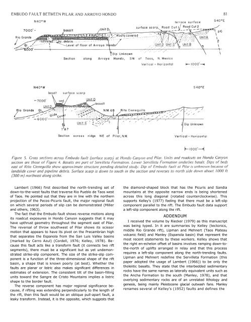
80 MUEHLBERGERbuilding Servilleta alluvial fans until, from <strong>Pilar</strong> onward, onlythe top package continues the length of Black Mesa nearly toEspanola. <strong>The</strong> lowest basalt of each package from Rio Pueblode Taos south nearly to <strong>Pilar</strong> is commonly partially altered toa greenish color. (Kono <strong>and</strong> others (1967) ascribed this to amontmorillonite clay from their samples in the Rio Pueblo deTaos.) This consistent relationship <strong>and</strong> the presence locally ofsoft-sediment deformation suggest that a playa or alluvial flatdeveloped <strong>between</strong> the northward-prograding alluvial fansfrom the rising Picuris Mountains <strong>and</strong> the southward-movingbasalt flows.<strong>The</strong>se olivine-tholeiites (Aoki, 1967) range in age from 4.5to 3.62 m.y. (Ozima <strong>and</strong> others, 1967). Manley (1976) reportedan age of 2.8 m.y. for the basalt capping Black Mesanear Espanola. This latter basalt appears to overlie the youngestpackage of the Rio Gr<strong>and</strong>e Gorge basalt <strong>and</strong> does not carryalong the mesa cap to <strong>Pilar</strong>. Instead, it appears to stay on thewest side of the mesa <strong>and</strong> continue north toward CerroMojino. Lipman (1978, p. 40) located the largest exposedsources of Servilleta basalts as two very-low-angle shield volcanoesa few kilometers east of Tres Piedras (30 mi (48 km)northwest of Taos, near the western edge of the Taos Plateau).South of the <strong>Embudo</strong> fault, a single discontinuous basaltcaps the mesa northeast of <strong>Pilar</strong>. A thin conglomerate at itsbase rests with angular unconformity across the Ojo CalienteMember of the Tesuque Formation. <strong>The</strong> basalt <strong>and</strong> underlyingconglomerate are thickest in the bluffs above <strong>Pilar</strong> where eachis nearly 40 ft (12 m) thick. Farther northeast, the basalt<strong>and</strong>/or the underlying conglomerate together are 20 ft (6 m)or less in thickness <strong>and</strong> are locally absent. Bent pipe vesicles donot give consistent flow directions (west near <strong>Pilar</strong> <strong>and</strong> southeasta mile farther east). Whether this flow correlates with thetop basalt or any of the four basalts that are exposed north ofthe <strong>Embudo</strong> fault along the mesa northeast of <strong>Pilar</strong> is unknown.<strong>The</strong>re are no identifiable differences in h<strong>and</strong> specimen.(Aoki (1967) remarked on the uniformity of these basaltsalong the Rio Gr<strong>and</strong>e Gorge to the north.)<strong>The</strong> youngest part of the Servilleta Formation in this area isextremely coarse <strong>and</strong> overlies the basalts of the Rio Gr<strong>and</strong>eGorge. <strong>The</strong> formation includes the alluvial-fan deposits of<strong>Arroyo</strong> <strong>Hondo</strong> deposited prior to the entrenching of <strong>Arroyo</strong><strong>Hondo</strong> in response to the active downcutting of the RioGr<strong>and</strong>e. Angular cobble- to boulder-sized clasts of phyllite,schist <strong>and</strong> quartzite litter the surface of the fan deposit. Remnantsof fan deposits overlie the basalt member of the ServilletaFormation, <strong>and</strong> in places, beheaded channels are presenton the mesa extending northeast from <strong>Pilar</strong>.<strong>The</strong> headward growth of Rito Cieneguilla <strong>and</strong> its majortributaries (Agua Caliente <strong>and</strong> Piedra Lumbre) gradually abstracted<strong>and</strong> diverted all drainages from the Picuris Mountainsthat crossed the <strong>Embudo</strong> fault; as a result, these drainagesbecame parallel to it to join the Rio Gr<strong>and</strong>e at <strong>Pilar</strong>. <strong>The</strong>numerous gravel deposits of this dissection have not beenstudied yet to determine whether they have structural as wellas climatic controls.EMBUDO FAULT<strong>The</strong> stratigraphic data presented in the previous sectionshow that erosion of Precambrian rocks from the PicurisMountains had begun already in late Santa Fe time (Ojo CalienteS<strong>and</strong>stone Member) or over 7 m.y. ago during the lateMiocene (using Manley's (1978) correlation chart). Thus, the<strong>Embudo</strong> fault was in existence by this time. Whether it wasactive earlier is not known, although the presence of PicurisTuff <strong>and</strong> its northward correlative, the Los Pinos Formation,which Lipman <strong>and</strong> Mehnert (1975) state marks the inceptionof Rio Gr<strong>and</strong>e rifting in southern Colorado, suggests that thisregion was subsiding, <strong>and</strong> that the <strong>Embudo</strong> fault was notactive or is at least unrecognized.<strong>The</strong> coarsening upward of Picuris-derived clasts indicatesthat the topographic relief <strong>between</strong> the San Luis Valley basin<strong>and</strong> the Picuris Mountains across the <strong>Embudo</strong> fault has beenincreasing. Using gravity data, Cordell (1976) postulates thatPrecambrian basement is at sea level a few kilometers north of<strong>Pilar</strong>. In contrast, the Picuris Mountains reach upward to10,810 ft (3,300 m) a few kilometers east of <strong>Pilar</strong>. Thus, structuralrelief across the fault zone is at least 10,000 ft (3,000 m),depending on the amount of eastward dip of the basement toTaos.<strong>The</strong> <strong>Embudo</strong> fault, as used here, is that fault which has amappable surface trace from <strong>Pilar</strong> northeast to <strong>Hondo</strong> Canyon.It also is visible for several kilometers southwest of <strong>Pilar</strong> as alinear groove that cuts the feet of the massive l<strong>and</strong>slides thatflank the Rio Gr<strong>and</strong>e. East of <strong>Hondo</strong> Canyon, the fault scarploses its sharp definition as it turns eastward so that onlydiscontinuous segments can be found <strong>and</strong> elsewhere it appearsto be masked by l<strong>and</strong>sliding.Microfaulted s<strong>and</strong>-dune facies of Unit D is displayed well inthe roadcuts for one-half mile (.8 km) southwest of where theroad reaches the Taos Plateau. Contradictory fault slip solutionshave been obtained using observed separations on bed set<strong>and</strong> crossbed set boundaries. Assuming that they formed afterthe beds had been rotated to their present attitudes, mostfaults striking north to west <strong>and</strong> dipping southwest (averaging45 ° ) show reverse-slip solutions, <strong>and</strong> steeply dipping faultsthat strike northeast show left strike-slip. Why some faults donot fit these patterns has yet to be resolved but may relate tothe timing of this microfaulting, <strong>and</strong> the uplift <strong>and</strong> tilting ofthe entire unit.<strong>The</strong> linearity of Rio Pueblo Taos suggests fault control, althoughit may be only a synclinal downwarp parallel to thegorge arch (fig. 2). <strong>The</strong> streams draining into the Rio Pueblode Taos have asymmetrical shapes with the steep slope on theeast, suggesting an eastward-tilting of this region as far as Taos.<strong>The</strong> northeastward projection of the gorge arch across <strong>New</strong><strong>Mexico</strong> Highway 3 to the mouth of the Rio <strong>Hondo</strong> marks theprominent drainage divide of streams draining west to the RioGr<strong>and</strong>e from streams draining south to the Rio Pueblo deTaos. <strong>The</strong> western boundary of this warped block appears tobe the down-to-the-east faults <strong>and</strong> monoclines that parallel theRio Gr<strong>and</strong>e from west of the village of <strong>Arroyo</strong> <strong>Hondo</strong> (trellisdrainage west of <strong>Arroyo</strong> <strong>Hondo</strong> (fig. 2)) south nearly to <strong>Pilar</strong>.<strong>The</strong> eastern boundary is marked by prominent piedmontscarps along the Sangre de Cristo range front. <strong>The</strong> range frontturns southwest to join the <strong>Embudo</strong> fault zone. <strong>The</strong> northtrendingfaulting <strong>between</strong> the Picuris-Pecos fault <strong>and</strong> thatacross Rio Gr<strong>and</strong>e del Rancho includes a variety of motions,most of which have yet to be sorted out. This area currently isbeing studied in detail as part of our program to unravel thedepositional <strong>and</strong> structural history of this region.<strong>The</strong> presence of basalt inliers at the surface of the piedmontslope from <strong>Hondo</strong> Canyon (fig. 5) east suggests that unidentifiedfaults underlie this surface <strong>and</strong> may aid in controlling thecourse of the Rio Pueblo de Taos immediately to the north.
Lambert (1966) first described the north-trending set ofdown-to-the-west faults that traverse Rio Pueblo de Taos westof Taos. He pointed out that they are in line with the northernprojection of the Pecos-Picuris fault, the major regional faulton which several periods of slip can be demonstrated (Miller<strong>and</strong> others, 1963).<strong>The</strong> fact that the <strong>Embudo</strong> fault shows reverse motions alongits roadcut exposures in <strong>Hondo</strong> Canyon suggests that it mayhave upthrust geometry throughout the segment east of <strong>Pilar</strong>.<strong>The</strong> reversal of throw southwest of <strong>Pilar</strong> shows its scissormotion that appears to have its pivot on the Precambrian highthat separates the Espanola from the San Luis Valley basins(marked by Cerro Azul) (Cordell, 1976; Kelley, 1978). Becausethis fault acts like a transform fault (it connects two riftsegments), there must be a significant but as yet undemonstratedstrike-slip component. <strong>The</strong> size of the strike-slip componentis a function of the three-dimensional shape of the riftbasin, a shape that is known poorly (at best). Whether thefaults are planar or listric also makes significant differences inestimates of extension. <strong>The</strong> consistent tilt of the basin-fillingunits toward the Sangre de Cristo Mountains implies a listricshape to the border fault.<strong>The</strong> reverse component has major regional significance because,if rifting was extending perpendicularly to the length ofthe rift, then this fault would be an oblique pull-apart fault, aleaky transform. Instead, it is the opposite, which suggests thatthe diamond-shaped block that has the Picuris <strong>and</strong> S<strong>and</strong>iamountains at the opposite narrow ends is being shortenedacross this long diagonal (rotated counterclockwise). Thissupports Kelley's (1977) feeling that there must be a left-slipcomponent parallel to the rift. <strong>The</strong> <strong>Embudo</strong> fault data supporta left-slip component along the rift.ADDENDUMI received the volume by Riecker (1979) as this manuscriptwas being typed. In it are summaries by Kelley (tectonics,middle Rio Gr<strong>and</strong>e rift), Lipman <strong>and</strong> Mehnert (Taos Plateauvolcanic field) <strong>and</strong> Manley (Espanola basin) that represent themost recent statements by these workers. Kelley shows thatthe right en-echelon offset of basins involves ramping down-tothe-northof uplifts arranged in relay <strong>and</strong> that this processrequires a left-slip component along the north-trending faults.Lipman <strong>and</strong> Mehnert redefine the Servilleta Formation (thispaper adopted the usage of Lambert (1966)) to be only thetholeiitic basalts. <strong>The</strong>y state that the interbedded sedimentaryrocks have the same names as laterally equivalent units such asthe Ancha Formation to the south (Manley, 1978), <strong>and</strong> thatoverlying sedimentary rocks are of an unrelated lithology <strong>and</strong>genesis, being mainly Pleistocene glacial outwash fans. Manleyrenames several of Kelley's (1952) faults <strong>and</strong> defines the