The Embudo Fault between Pilar and Arroyo Hondo, New Mexico ...
The Embudo Fault between Pilar and Arroyo Hondo, New Mexico ...
The Embudo Fault between Pilar and Arroyo Hondo, New Mexico ...

Create successful ePaper yourself
Turn your PDF publications into a flip-book with our unique Google optimized e-Paper software.
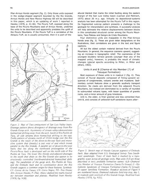
78 MUEHLBERGER<strong>Pilar</strong>-<strong>Arroyo</strong> <strong>Hondo</strong> segment (fig. 2). Only those units exposedin the wedge-shaped segment bounded by the Rio Gr<strong>and</strong>e,<strong>Arroyo</strong> <strong>Hondo</strong> <strong>and</strong> <strong>New</strong> <strong>Mexico</strong> Highway 68 will be describedin this paper, which is an updating of work I reported inHawley (1978, p. 41-46). <strong>The</strong> Picuris Tuff, exposed along thebase of the Picuris Mountains east of <strong>Arroyo</strong> <strong>Hondo</strong>, underliesthe units to be described <strong>and</strong> apparently predates the uplift ofthe Picuris Mountains. If the Picuris Tuff is a correlative of theAbiquiu Tuff, as is usually presumed, then it is part of thealluvial blanket that marks the initial faulting along the easternmargin of the San Luis Valley basin (Lipman <strong>and</strong> Mehnert,1975) about 26 m.y. ago. Virtually no depositional-systemsanalysis has been attempted for the Picuris Tuff in this region.Its fragmented outcrop pattern presents a challenge to thegeologist for interpretation <strong>and</strong> synthesis. A successful analysiswill help delineate the relative displacements <strong>between</strong> blocksin this complicated structural corner among the Picuris Mountains,Taos Plateau <strong>and</strong> Sangre de Cristo Mountains.Four distinctive units are mappable in the <strong>Pilar</strong>-<strong>Arroyo</strong><strong>Hondo</strong> area (fig. 3). <strong>The</strong>se are given letter designations on theillustrations; their correlations are given in the text <strong>and</strong> figurecaptions.All but the oldest contain material derived from the PicurisMountains. In general, the sequence coarsens upward, suggestingan increase in topographic relief. <strong>The</strong> coarseness of theyoungest bouldery terrace gravels (younger than any of themapped units), however, is probably the result of climaticchanges (glacial epochs according to Miller, in Miller <strong>and</strong>others, 1963).Units A <strong>and</strong> B (Chama-el rito Member (?) ofTesuque Formation)Best exposure of these units is in roadcut 2 (fig. 4). <strong>The</strong>yconsist of fluvial deposits composed of fining-upward sequencesof conglomerate, volcanic arenite <strong>and</strong> mudstone. Sedimentarycurrent features show a generally southerly transportdirection. No clasts are derived from the adjacent PicurisMountains, but instead are dominated by a variety of roundedto subrounded volcanic types, with lesser quantities of graniticrocks, <strong>and</strong> a minor amount of gray limestone.Unit A, the older, is finer grained <strong>and</strong> less cemented thanUnit B, <strong>and</strong> consists of yellowish-buff s<strong>and</strong>stone layers alter-