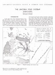
Oil and gas exploration wells in the Pedregosa Basin - New Mexico ...
Oil and gas exploration wells in the Pedregosa Basin - New Mexico ...
Oil and gas exploration wells in the Pedregosa Basin - New Mexico ...

Create successful ePaper yourself
Turn your PDF publications into a flip-book with our unique Google optimized e-Paper software.
O I L A N D G A S E X P L O R A T I O N W E L L S<br />
Nor<strong>the</strong>astern Sonora<br />
Pennsylvanian rocks of nor<strong>the</strong>astern Sonora were <strong>in</strong>cluded<br />
with Permian rocks <strong>in</strong> <strong>the</strong> Naco Group of some early refer -<br />
ences. At least <strong>the</strong> nor<strong>the</strong>rnmost Pennsylvanian sections are<br />
correlated with <strong>the</strong> Black Pr<strong>in</strong>ce, Horquilla <strong>and</strong> lo wer Earp<br />
units of sou<strong>the</strong>astern Arizona.<br />
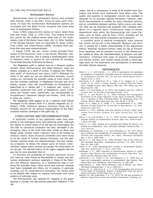
Tovar (1969) measured <strong>the</strong> section at Canon Santa Rosa<br />
(see also Imlay, 1939, p. 1730-1732). This locality provides<br />
key control for <strong>the</strong> shallow-mar<strong>in</strong>e shelf area on <strong>the</strong> southwestern<br />
side of <strong>the</strong> Alamo Hueco bas<strong>in</strong> (fig. 3). O<strong>the</strong>r localities<br />
<strong>in</strong> <strong>the</strong> Bavispe-Nacozari area are described by Imlay (1939),<br />
Fries (1962) <strong>and</strong> LOpez-Ramos (1969), <strong>in</strong>clud<strong>in</strong>g some sections<br />
that have been metamorphosed.<br />
F. Rang<strong>in</strong> (1978, <strong>and</strong> per. comm.) k<strong>in</strong>dly provided thicknesses<br />
of Pennsylvanian rocks <strong>in</strong> <strong>the</strong> Morita, Mestenas, Can -<br />
anea <strong>and</strong> Tule sections. She is mak<strong>in</strong>g a biostratigraphic study<br />
of Paleozoic rocks <strong>in</strong> Sonora for <strong>the</strong> Institute de Geologia,<br />
Universidad Nacional AutOnoma de <strong>Mexico</strong>.<br />
The Magdalena uplift is def<strong>in</strong>ed here as a Mesozoic positive<br />
element where Pennsylvanian <strong>and</strong> o<strong>the</strong>r Paleozoic rocks are<br />
absent, probably as a result of erosion. It replaces <strong>the</strong> "Hermosillo<br />
uplift" of Greenwood <strong>and</strong> o<strong>the</strong>rs (1977). Although <strong>the</strong><br />
limits of <strong>the</strong> uplift are not yet determ<strong>in</strong>ed precisely, current<br />
studies are narrow<strong>in</strong>g <strong>the</strong> possible range of areal extent. At<br />
two key localities sou<strong>the</strong>ast of Magdalena (Cucurpe <strong>and</strong> Cerro<br />
Prieto), Jurassic rocks rest unconformably on Precambrian as<br />
determ<strong>in</strong>ed by C. Rang<strong>in</strong> <strong>and</strong> T. H. Anderson (per. comm.). At<br />
localities southwest <strong>and</strong> north of Magdalena, Lower Creta -<br />
ceous <strong>and</strong> Tertiary rocks, respectively, rest unconformably on<br />
Precambrian(?) basement (Rang<strong>in</strong> <strong>and</strong> Roldan, 1978; <strong>and</strong> G.<br />
A. Solos, per. comm.).<br />
The Magdalena uplift appears to be a relatively small feature<br />
developed on <strong>the</strong> eastern flank of a Jurassic magmatic arc (C.<br />
Rang<strong>in</strong>, 1978). Extensive igneous <strong>in</strong>trusions along <strong>the</strong> arc<br />
probably account for <strong>the</strong> general metamorphism of <strong>the</strong> Pennsylvanian<br />
sections nor<strong>the</strong>ast of <strong>the</strong> uplift (fig. 3).<br />
CONCLUSIONS AND RECOMMENDATIONS<br />
A significant number of key <strong>exploration</strong> <strong>wells</strong> have been<br />
drilled <strong>in</strong> <strong>the</strong> <strong>Pedregosa</strong> bas<strong>in</strong> <strong>and</strong> adjo<strong>in</strong><strong>in</strong>g areas. Although<br />
<strong>the</strong> reports of several shows of oil <strong>and</strong> <strong>gas</strong> are encourag<strong>in</strong>g, <strong>the</strong><br />
fact that no commercial production has been developed is discourag<strong>in</strong>g.<br />
Many of <strong>the</strong> <strong>wells</strong> have been drilled on Bas<strong>in</strong> <strong>and</strong><br />
Range uplifts (horsts) where reservoirs tend to be flushed by<br />
meteoric waters. Some structural anomalies have been found<br />
to be <strong>the</strong> result of Tertiary igneous <strong>in</strong>trusions, <strong>and</strong> <strong>the</strong> sedimentary<br />
sections locally are metamorphosed. The best rema<strong>in</strong><strong>in</strong>g<br />
prospects lie below <strong>the</strong> deeper parts of bolson (<strong>in</strong>ter -<br />
montane) valleys where chances are greater for preservation of<br />
oil <strong>and</strong> <strong>gas</strong>. The <strong>the</strong>rmal history of <strong>the</strong> region suggests that dry<br />
<strong>gas</strong> may be more abundant than oil.<br />
To maximize <strong>the</strong> probability of success, petroleum source<br />
<strong>and</strong> reservoir rocks should be documented <strong>in</strong> surface <strong>and</strong> subsurface<br />
stratigraphic sections, especially <strong>in</strong> those of <strong>the</strong> Paleozoic<br />
<strong>and</strong> Mesozoic objectives, as a fundamental step <strong>in</strong> outl<strong>in</strong><strong>in</strong>g<br />
<strong>the</strong> favorable areas. Some source <strong>and</strong> reservoir analyses<br />
have been completed <strong>and</strong> o<strong>the</strong>rs are <strong>in</strong> progress <strong>in</strong> particular<br />
localities, but for comprehensive evaluation, <strong>the</strong> results need<br />
to be plotted with respect to regional thicknesses <strong>and</strong> facies<br />
patterns of <strong>in</strong>dividual units.<br />
The Pennsylvanian was selected for mapp<strong>in</strong>g <strong>in</strong> this paper<br />
because it <strong>in</strong>cludes <strong>the</strong> top-rank<strong>in</strong>g <strong>exploration</strong> objective <strong>in</strong> <strong>the</strong><br />
341<br />
region, <strong>and</strong> as a consequence it tends to be studied more thoroughly<br />
<strong>and</strong> drilled more extensively than o<strong>the</strong>r units. The<br />
quality <strong>and</strong> quantity of stratigraphic control now available is<br />
adequate for an accurate regional framework. However, additional<br />
documentation is needed for many <strong>in</strong>dividual sections,<br />
<strong>and</strong> on correlations between sections, before source <strong>and</strong> reservoir<br />
data can be evaluated <strong>and</strong> projected with complete confidence<br />
on a regional basis. Fur<strong>the</strong>rmore, maps of th<strong>in</strong>ner<br />
depositional units with<strong>in</strong> <strong>the</strong> Pennsylvanian <strong>and</strong> Lower Per -<br />
mian, such as those used by Ross (1973), probably will be<br />
needed for <strong>the</strong> most precise evaluations <strong>and</strong> projections.<br />
A complete series of regional stratigraphic maps show<strong>in</strong>g<br />
key control unit-by-unit <strong>in</strong> <strong>the</strong> Paleozoic, Mesozoic <strong>and</strong> Cenozoic<br />
is needed for a better underst<strong>and</strong><strong>in</strong>g of <strong>the</strong> depositional<br />
history. Regional structure-contour maps on top of Precambrian<br />
basement <strong>and</strong> on selected horizons <strong>in</strong> <strong>the</strong> Phanerozoic<br />
are needed to show <strong>the</strong> <strong>in</strong>terrelationships of tectonics <strong>and</strong> sedimentation.<br />
Comb<strong>in</strong>ed with maps of plutonic, metamorphic<br />
<strong>and</strong> volcanic activity, such studies should provide a sound geologic<br />
basis for <strong>the</strong> <strong>exploration</strong> <strong>and</strong> development of petroleum<br />
<strong>and</strong> o<strong>the</strong>r m<strong>in</strong>eral resources.<br />
REFERENCES<br />
Aiken, C. L. V., <strong>and</strong> Sumner, J. 5., 1974, A geophysical <strong>and</strong> geological<br />
<strong>in</strong>vestigation of potentially favorable areas for petroleum <strong>exploration</strong><br />
<strong>in</strong> sou<strong>the</strong>astern Arizona: Ariz. <strong>Oil</strong> <strong>and</strong> Gas Conservation Comm.,<br />
Report of Inv. 3, 44 p.<br />
Armstrong, A. K., Silberman, M. L., Todd, V. R., Hoggat, W. C., <strong>and</strong><br />
Carter, R. D., 1978, <strong>in</strong> press, Geology of central Peloncillo Moun -<br />
ta<strong>in</strong>s, Hidalgo County, <strong>New</strong> <strong>Mexico</strong>, <strong>New</strong> Mex. Bur. M<strong>in</strong>es <strong>and</strong> M<strong>in</strong>.<br />
Resources Circ. 158.<br />
Conley, J. N. <strong>and</strong> Stacey, 0. A., 1977, Well location map four, State of<br />
Arizona: Ariz. <strong>Oil</strong> <strong>and</strong> Gas Conservation Comm., 23 p.<br />
Diaz G., T., <strong>and</strong> Navarro G., A., 1964, Lithology <strong>and</strong> stratigraphic<br />
correlation of <strong>the</strong> Upper Paleozoic <strong>in</strong> <strong>the</strong> region of Palomas, Chihuahua,<br />
<strong>in</strong> Geology of M<strong>in</strong>a Plomosas-Placer de Guadalupe area, Chihuahua,<br />
<strong>Mexico</strong>: West Texas Geol. Soc. Pub. 64-50, p. 65-84.<br />
Dixon, G. H., Baltz, D. H., Stipp, T. F., <strong>and</strong> Bieberman, R. A., 1954,<br />
Records of <strong>wells</strong> drilled for oil <strong>and</strong> <strong>gas</strong> <strong>in</strong> <strong>New</strong> <strong>Mexico</strong>: U.S. Geol.<br />
Survey Circ. 333, 79 p.<br />
Drewes, H., 1977, Geologic map <strong>and</strong> sections of R<strong>in</strong>con Valley quadrangle,<br />
Pima County, Arizona: U.S. Geol. Survey Misc. Inv. Map<br />
1-997.<br />
Eberly, L. D., <strong>and</strong> Stanley, T. B., Jr., 1978, Cenozoic stratigraphy <strong>and</strong><br />
geologic history of southwestern Arizona: Geol. Soc. America Bull.,<br />
v. 89, p. 921-940.<br />
Fries, C., Jr., 1962, Reseria de la geologia del Estado De Sonora, con<br />
enfasis en el Paleozoico: Asoc. Mexicana GeOlogos Petroleros Bol., v.<br />
14, p. 257-273.<br />
Greenwood, E., Kottlowski, F. E., <strong>and</strong> Thompson, S., III, 1977, Petroleum<br />
potential <strong>and</strong> stratigraphy of <strong>Pedregosa</strong> bas<strong>in</strong>: comparison with<br />
Permian <strong>and</strong> Orogr<strong>and</strong>e bas<strong>in</strong>s: Am. Assoc. Petroleum Geologists<br />
Bull., v. 61, p. 1448-1469.<br />
Hayes, P. T., <strong>and</strong> Raup, R. B., 1968, Geologic map of <strong>the</strong> Huachuca<br />
<strong>and</strong> Mustang Mounta<strong>in</strong>s, sou<strong>the</strong>astern Arizona: U.S. Geol. Survey<br />
Misc. Inv. Map 1-509.<br />
Imlay, R. W., 1939, Paleogeographic studies <strong>in</strong> nor<strong>the</strong>astern Sonora:<br />
Geol. Soc. America Bull., v. 50, p. 1723-1744.<br />
Kottlowski, F. E., 1960, Summary of Pennsylvanian sections <strong>in</strong> southwestern<br />
<strong>New</strong> <strong>Mexico</strong> <strong>and</strong> sou<strong>the</strong>astern Arizona: <strong>New</strong> Mex. Bur.<br />
M<strong>in</strong>es <strong>and</strong> M<strong>in</strong>. Resources Bull. 66, 187 p.<br />
Kottlowski, F. E., Foster, R. W., <strong>and</strong> Wengerd, S. A., 1969, Key oil<br />
tests <strong>and</strong> stratigraphic sections <strong>in</strong> southwestern <strong>New</strong> <strong>Mexico</strong>: <strong>New</strong><br />
<strong>Mexico</strong> Geol. Soc. Guidebook, 20th Field Conf., p. 186-196.<br />
LOpez-Ramos, E., 1969, Mar<strong>in</strong>e Paleozoic rocks of <strong>Mexico</strong>: Am. Assoc.<br />
Petroleum Geologists Bull., v. 53, p. 2399-2417.<br />
Navarro G., A., <strong>and</strong> Tovar R., J. C., 1975, Stratigraphy <strong>and</strong> tectonics<br />
of <strong>the</strong> State of Chihuahua, <strong>Mexico</strong>, <strong>in</strong> Exploration from <strong>the</strong> mounta<strong>in</strong>s<br />
to <strong>the</strong> bas<strong>in</strong>: El Paso Geol. Soc., p. 23-27.<br />
Pearson, B., <strong>and</strong> Underwood, J. R., Jr., 1975, <strong>Oil</strong> <strong>and</strong> <strong>gas</strong> prospects of<br />
western Trans-Pecos Texas <strong>and</strong> nor<strong>the</strong>rn Chihuahua, <strong>in</strong> Geology of