- Page 1 and 2:
M"^'*^: k^"'"^' >;.^ . ^:* ^/^
- Page 7 and 8:
LISRAi?Y ^FTME UNIVERSITY of ILLINO
- Page 9 and 10:
THE EARTH AND ITS INHABITANTS THE U
- Page 11 and 12:
CnAP. CONTEXTS. I. The Cextrai. isi
- Page 13 and 14:
LIST OF ILLUSTEATIONS. PAGE 1. The
- Page 15 and 16:
FTO. lOi). 101. 10-2. 103. 104. 10.
- Page 17 and 18:
THE UNIVEESAL GEOGRAPHY. WEST AFRIC
- Page 19 and 20:
CHANGES IN THE RELIEF OF THE ATLA>;
- Page 21 and 22:
THE AZOELiX WATERS. 5 drawn between
- Page 23 and 24:
RELIEF, GEOLOGY, AXD TEMTEEATUBE OF
- Page 25 and 26:
TEMPERATURE OF THE AZORIAN BASIX. g
- Page 27 and 28:
ATMOSPHEEIC CUEEENTS OF THE AZOEIAN
- Page 29 and 30:
MAEESTE CUEEEXT3 OF THE AZOEIAN B^V
- Page 31 and 32:
THE GUIXEA WATEES. ir, American coa
- Page 33 and 34:
THE GUINEA STEEAM. 17 two insular g
- Page 35 and 36:
THE GUIXKA STREAM. 19 current flowi
- Page 37 and 38:
TEMPERATURE—FAUNA. 21 Guinea wate
- Page 39 and 40:
CHAPTER II. "\^"EST AFRIC-iN ISLAIS
- Page 41 and 42:
CLtMATE OF THE AZOEES. 25 western g
- Page 43 and 44:
FLORA OF THE AZOBES. 27 gardens. Th
- Page 45 and 46:
INHABITAlSrTS OF THE AZOEES. 29 Eff
- Page 47 and 48:
INHABITANTS OF THE AZORES. 31 tour
- Page 49 and 50:
TOPOGEAPnr OF THE AZOEES. 33 indust
- Page 51 and 52:
TOPOGRAPHY OF THE AZOEES. STuninlt
- Page 54 and 55:
ilBRAK^ OF THE iJNIVERSITy of ILLIN
- Page 56 and 57:
38 WEST AFRICA. hoiu-s it was alrca
- Page 58 and 59:
40 WEST AJTEICA. and vapour at a te
- Page 60 and 61:
42 WEST AFEICA. San-Jorge, and from
- Page 62:
44 WEST ATBICA. encircled by deep w
- Page 66 and 67:
46 WEST AFRICA. falls little short
- Page 68 and 69:
48 "U'Ei'T AFRICA. from the normtil
- Page 70 and 71:
50 WEST AFRICA. uudergonc Ijut slig
- Page 72 and 73:
62 WEST AFRICA. favoured climate. S
- Page 74 and 75:
OF THE UNIVERSITY of ILLINOIS.
- Page 76 and 77:
64 WEST AFRICA. Topography. The pre
- Page 78 and 79:
56 WEST AFRICA. a Genoese fleet had
- Page 80 and 81:
West of Grvemnch. GOMERA f'Jf Tmo S
- Page 83 and 84:
GEOLOGY OP THE CANAEIES. 57 gucse p
- Page 85 and 86:
FLOEA OF THE CANAEIES. 59 The C;mar
- Page 87 and 88:
INHAEITAiiTS OF TIIE CANAEIES. Gl t
- Page 89 and 90:
INHABITANTS OF THE CANARIES. 63 bei
- Page 91 and 92:
a o 5 So TXFATiTTANTR OF THE CANAEI
- Page 93 and 94:
T^NZAEOTE. 67 and one of them is ue
- Page 95 and 96:
GEAN CANAEIA. C9 cone rising above
- Page 97 and 98:
GRAN CANABIA. 71 fathoms of water f
- Page 99 and 100:
TENEEITFE. 73 Sierra de Teno, datin
- Page 101 and 102:
TENEEIFFE. 75 land and sea, but in
- Page 103 and 104:
GOMEEA. 77 a strait 17 miles wide.
- Page 105 and 106:
PALMA. 79 San-Sclasiian, the capita
- Page 107 and 108:
ADMINISTEATION OF THE CANAEIES. 81
- Page 109 and 110:
C^VPE \T3ED ISLAISTDS. 83 Santa-Luz
- Page 111 and 112:
CAPE VEED ISLANDS. 85 The general s
- Page 113 and 114:
CAPE YEED ISLAJfDS. 87 labour throu
- Page 115 and 116:
CAPE YEED ISLANDS. 89 laud of the a
- Page 117 and 118:
.'(,'tl O S5 a o 6
- Page 119 and 120:
CAPE VEED ISLANDS. 91 Saixt Yixxext
- Page 121 and 122:
CAPE VEED ISLANDS. 93 feet, a ruine
- Page 123 and 124:
CAPE VEED ISLANDS. 95 combines in h
- Page 125 and 126:
TRISTAM DA CUNHA. 97 also figured o
- Page 128 and 129:
LIBRARY OF THE UNIVERSITY of U\N01b
- Page 130 and 131:
100 WEST AFRICA. soldiers obtained
- Page 132 and 133:
102 "WEST APEICA. Climate. The grow
- Page 134 and 135:
104 WEST AFEICA. about 1840, and wl
- Page 136 and 137:
LIBRARY OF THE UNIVERSITY of ILLlNO
- Page 138 and 139:
106 WEST AFEICA. vessels to seek sh
- Page 140 and 141:
108 "WEST AFRICA. the guinea-fowl.
- Page 142 and 143:
110 WEST AFRICA. Fig. 43. Cascade o
- Page 144 and 145:
112 WEST APEICA. features in its na
- Page 146 and 147:
114 WEST AFEICA. divided into two s
- Page 148 and 149:
116 WEST APEIOA. different race of
- Page 150 and 151:
118 WEST AFEIOA. exiles have return
- Page 152 and 153:
]20 WEST AFEICA. Futa-Jallon highla
- Page 154 and 155:
122 WEST AFRICA. first expedition i
- Page 156 and 157:
124 "WEST AFEIOA. This highland sys
- Page 158 and 159:
126 WEST AFEICA. coherence. Tliej'
- Page 160 and 161:
128 WEST AFEICA. are no longer dire
- Page 162 and 163:
Leyb, Gandon -Dialakhar Rao Poundio
- Page 165 and 166:
SENECJAL BASIX AXD FUTA-JALLON. 129
- Page 167 and 168:
TKE SENEGAL BASIN. 131 flow in the
- Page 169 and 170:
THE SEXEGAL DELTA. 133 surprisingly
- Page 171 and 172:
FLOEA OF SENEGAL. 136 During the fo
- Page 173 and 174:
FAUNA OF SENEGAL. 137 a thorny zizy
- Page 175 and 176:
INHABITANTS OF SENEGAL. 189 women a
- Page 177 and 178:
THE WOLOFS. 141 and the Gambia. The
- Page 179 and 180:
THE SEEEBS. 143 The "Wolofs are tho
- Page 181 and 182:
THE SAEAKOLES. 146 inclining to red
- Page 183 and 184:
THE FULAHS. 147 between the Senegal
- Page 185 and 186:
THE TOUCOTJLEUES. 149 the images of
- Page 187 and 188:
Pi E-" a < < cs < a C-i
- Page 189 and 190:
TEADE OP SENEGAL. 151 peans can onl
- Page 191 and 192:
MIXEEALS OF SE>rEGAL—GOLD-iUXIXG.
- Page 193 and 194:
POLITICAL STATE OF SENEGAL. 155 vra
- Page 195 and 196:
TOPOGRAPETT OF SE^'EGAJ.. 157 as fa
- Page 197 and 198:
TOPOGEAPHT OF SENEGAL. 159 The Argu
- Page 200 and 201:
UBRAP.Y OF THE UNIVERSITY of ILLINO
- Page 202:
162 WEST AFRICA. mines. But " the g
- Page 205 and 206:
TOPOaRAPHY OF SENEGAL. 163 of their
- Page 207 and 208:
TOPOGRAPHY OF SENEGAL. 165 however,
- Page 209 and 210:
ABillNISTEATION OF FUTA-JALLON. 167
- Page 211 and 212:
ADiOXISTEATIOX OF SENEGAL. 169 form
- Page 213 and 214:
±'''^£-
- Page 215 and 216:
FLOEA OF GAMBLL 173 Noirot, Ke to t
- Page 217 and 218:
THE 11A^T)IXGANS. 175 tremendous po
- Page 219 and 220:
DISTRICT OF IL^"TOE. 177 situated f
- Page 221 and 222:
CASAMANZA BASIN. 179 stations, and
- Page 223 and 224:
FELUP TYPES
- Page 225 and 226:
CASAMANZA BASIX. 181 ctarms, and ho
- Page 227 and 228:
GUINfi. 183 channels danoreroiis to
- Page 229 and 230:
THE BISSAGOS AECHIPELAGO. 185 which
- Page 231 and 232:
IXIIABIT/VNTS OP GUIXE. 187 ciiddle
- Page 233 and 234:
BUJAGO TYPES AND TEKMtKS' KEST.
- Page 235 and 236:
INHABITANTS OF GTJINE. 189 bad luck
- Page 237 and 238:
THE SOUrn SEXEGAMBIAN EIYERS. 101 b
- Page 239 and 240:
THE LOS LSLANDS. 198 is of perfectl
- Page 241 and 242:
THE SU-SU TEIBE. 195 vras a Su-Su t
- Page 243 and 244:
SIEKEA-LEONE. I97 people now mostly
- Page 245 and 246:
SIEERA-LEONE. 199 bristles witli ca
- Page 247 and 248:
SIEBEA-LEOXE. 201 degrees, from 75"
- Page 249 and 250:
SIEEEA-LEONE. 203 Inhabitants. The
- Page 251 and 252:
SIEEEA-LEONi:. 205 N'orth-east of t
- Page 253 and 254:
SIEREA-LEONE. 207 dailv gaining gro
- Page 255 and 256:
. ^ SIEEBA-LEONE. 209 out among the
- Page 257 and 258:
iSlEKEA-LEONE. 211 Administration.
- Page 259 and 260:
LIBERIA. 213 After the first diffic
- Page 261 and 262:
LIBEEIA. 216 quadrilateral, stretch
- Page 263 and 264:
KEOOSIEN.
- Page 265 and 266:
LIBERIA. 217 the morning, following
- Page 267 and 268:
LIBEELV. Bassas, the Kroos south of
- Page 269 and 270:
LIBEELV. 221 jocular Euglisli uickn
- Page 271 and 272:
LIBERIA. 223 The foreign trade of L
- Page 273 and 274:
LIBERIA. 225 liave a school and a m
- Page 275 and 276:
LIBEEIA. 227 beeD several times occ
- Page 277 and 278:
THE IVORY COAST. 229 and Maryland.
- Page 279 and 280:
THE IVOEY COAST. 231 Bassam mouth,
- Page 281 and 282:
THE KING OF ASSINI.
- Page 283 and 284:
INHABITANTS OF THE IVORY COAST. 233
- Page 285 and 286:
THE GOLD COAST. from the interior a
- Page 287 and 288:
THE GOLD COAST. 237 Physical Featur
- Page 289 and 290:
CLIMATE OF THE GOLD COAST. 239 In t
- Page 292 and 293:
OF Th r. UHiVERSlTVof ILUNUib,
- Page 294 and 295:
242 "WEST AFRICA, differs, except i
- Page 296 and 297:
244 WEST AFEICA. of the ilandingans
- Page 298 and 299:
246 WEST AI"EICA. all the bottles a
- Page 300 and 301:
248 WEST APKICA. command the Ancobr
- Page 302 and 303:
LIBRARY OF THE UNIVERSITY of ItLINO
- Page 304 and 305:
250 WEST APEICA. route leading thro
- Page 306 and 307:
252 WEST AFEICA. Between Accra and
- Page 308 and 309:
254 WEST AFEICA. protecting fetish.
- Page 310 and 311:
256 WEST AFRICA. European traders.
- Page 312 and 313:
253 WEST AFEICA. for a considerable
- Page 314 and 315:
2C0 WEST AFEICA. Steamers already p
- Page 316 and 317:
262 "NTOST AFRICA. war dances are p
- Page 318 and 319:
264 \\'EST AFEICA. The Yorubas are
- Page 320 and 321:
266 WEST AFRICA. ably increased the
- Page 322:
2G8 Fig. 118. -Dahomey and Axuda Co
- Page 325 and 326:
POETO-XOYO. 269 Botli places are co
- Page 327 and 328:
LAGOS. 271 In the basin of the Okpa
- Page 329 and 330:
a TOETJBA. 273 Tbndan, till recentl
- Page 331 and 332:
CHAPTER VII. THE NIGER BASIN. Gexer
- Page 333 and 334:
THE NIGEE. 271 expeditiou up the Co
- Page 335 and 336:
W I fee THE NIGEE. 279 in four mont
- Page 337 and 338:
THE NIGEE. 281 The Upper ajju SIidd
- Page 339 and 340:
THE MIDDLE NIGER. 283 of obelisks,
- Page 341 and 342:
THE BENTJE. 285 the largest headstr
- Page 343 and 344:
THE BENTJE. 287 direction in valley
- Page 345 and 346:
THE TOUCOULETJE EMPIEE. 289 ing the
- Page 347 and 348:
THE BAMBAEAS. 291 Inhabitants of th
- Page 349 and 350:
YOUNG BAMBAEAS.
- Page 351 and 352:
TOWNS OF THE UPPER NIGER. 293 resid
- Page 353 and 354:
BAlIAJnj. 295 noi;v "protected " by
- Page 355 and 356:
MASSINA. 297 between Jallonke-diigu
- Page 357 and 358:
Irl O M z
- Page 359 and 360:
MASSINA. 299 point from Bamuku reac
- Page 361 and 362:
THE SONGHAIS. 301 collective name o
- Page 363 and 364:
TIMBTJKTU. 803 Songhai of Timbuktu,
- Page 365 and 366:
GAEU.—DOEE.—SAI. 805 when some
- Page 367 and 368:
HAUSSA LAXD. 307 esh'mates of ten m
- Page 369 and 370:
HAUSSA LAND. 309 plants the most ^d
- Page 371 and 372:
HAUSSA LAND. 811 presence in Sokoto
- Page 373 and 374:
KATSENA. 813 thousand persons rende
- Page 375 and 376:
WUBNO—SOKOTO. 315 raised on the s
- Page 377 and 378:
GANDO. 817 the capital of "West Hau
- Page 379 and 380:
TATIRI—BTJSSA. 319 present the la
- Page 381 and 382:
s;0NnilioAllsa3AiNf 3 HI do
- Page 383:
R NICER \ / Aktu; AssaWa Ebo .'^
- Page 386 and 387:
322 WEST AFEICA. recent foundation,
- Page 388 and 389:
824 WEST AFEICA. Wurno. Imperial de
- Page 390 and 391:
326 WEST AFEICA. vallevs into disti
- Page 392 and 393:
328 WEST AFEICA. seen, is very comm
- Page 394 and 395:
330 WEST AFEICA. eveiywhere cultiva
- Page 396 and 397:
832 WEST AFEICA. venenosum), whicli
- Page 398 and 399:
334 "^VEST Ai-RICA. North-east of Y
- Page 400 and 401:
336 WEST AFEICA. (Kogna), from the
- Page 402 and 403:
LIBRARY OF THE INIVERSITyoftLLlNOiS
- Page 404 and 405:
338 WEST AFRICA. aud has also the a
- Page 406 and 407:
340 WEST AFEICA, have been sold in
- Page 408 and 409:
LIBRARY OF THE UNIVERSITY of ILLINO
- Page 410 and 411:
CHAPTER rni. the tsad basix. Ge>-er
- Page 412 and 413:
344 WEST APEICA. soiith tlie twin-c
- Page 414 and 415:
346 WTilST AFEICA. the Siberian Bal
- Page 416 and 417:
343 -^VEST AFEICA. rainfall taken t
- Page 418 and 419:
m 350 WEST AFEICA.
- Page 420 and 421:
352 t\t;st afeica. Crops are also r
- Page 422 and 423:
354 WEST AFEICA. tte sultan has to
- Page 424:
356 WEST APEICA. this region. In va
- Page 427 and 428:
KANEM. 857 difPerent races, are con
- Page 429 and 430:
BOEXU. 359 from Kauciu and by the i
- Page 431 and 432:
BOENU. 361 other rivals as the chie
- Page 433 and 434:
BOENU. 363 towns farther north are
- Page 436 and 437:
LIBRARY OF THE UNIVERSITY oflLLINOI
- Page 438 and 439:
366 WEST AFRICA. tion to Bagliirmi
- Page 440 and 441:
LiBRARV OF THE Ul^iVERSlTY of ILLIN
- Page 442 and 443:
368 WEST AFRICA. which -was capture
- Page 444 and 445:
EasLof Paris G° 30 ^r { A I.ftnri
- Page 447 and 448:
CHAPTER IX. THE CAMEEOONS. GrENERAL
- Page 449 and 450:
THE CAMEEOONS. 871 Rey, and in the
- Page 451 and 452:
THE CAMEEOONS. 373 dominates the lo
- Page 453 and 454:
THE C.IMEROONS. S75 network of tall
- Page 455 and 456:
THE aiMEEOONS. 877 are also emtelli
- Page 457 and 458:
THE CiMEEOONS. 879 tam-tam or driim
- Page 459 and 460:
THE CAMEEOONS. tliose of larger siz
- Page 461 and 462:
THE C.!lM;EEOOXS. 383 Elephant ilou
- Page 463 and 464:
3N1VERSITY of ILLINOIS,
- Page 465:
A B N POvillo 3tio teo 320 ufwS^dt.
- Page 468 and 469:
386 WEST AFEICA. FrencH and Spanisl
- Page 470 and 471:
388 WEST APEICA. also navigable by
- Page 472 and 473:
LIBRARY OF THE '.)NIVERSITY of ILLI
- Page 474 and 475:
390 \VEST AFEICA. sea below the Sct
- Page 476 and 477:
402 WEST AFRICA. childreu being ent
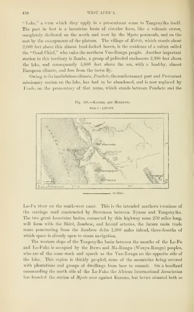
- Page 478 and 479:
894 WEST AFKIOA. Inhabitants. The i
- Page 480 and 481:
LIBRARY OF THE UNIVERSlTYoflUWOlS.
- Page 482 and 483:
396 WEST AFRICA. The Fans. Most of
- Page 484 and 485:
398 \VEST APEICA. The practice of c
- Page 486 and 487:
LIBRARV OF THE 'JNIVERSiTy of ILLIN
- Page 488 and 489:
400 "WEST AFRICA. tlie dead to tree
- Page 490 and 491:
402 WEST AFRICA. children being ent
- Page 492:
404 WEST AFEIOA. Libreville tas sca
- Page 495 and 496:
FEANCEVILLE. 405 named from the exp
- Page 497 and 498:
LOANGO. 407 the prevailing winds. G
- Page 499 and 500:
LAJSTDANA. 409 consists chiefly in
- Page 501 and 502:
CHAPTEE XI. CONGO BASIN. General Su
- Page 503 and 504: EXPLOEATIOX OF THE CONGO. 413 lake
- Page 505 and 506: EXPLOBATIOX OF THE CONGO BASIN. 415
- Page 507 and 508: LAKE BANGWEOLO. feet, and here seve
- Page 509 and 510: THE TKAYELLEfi GIKAtlD AiUD THE EEE
- Page 511 and 512: THE KAilOLOXDO B.iSIX. 419 Lake Moe
- Page 513 and 514: TANGANYIKA.. Of all the Central Afr
- Page 515 and 516: TA2JGANYIKA. 423 flooding caused by
- Page 517 and 518: THE MIDDLE CONGO. 425 surrounding g
- Page 519 and 520: I § R THE MIDDLE CONGO. 427 It is
- Page 521 and 522: THE MIDDLE CONGO. 429 160 feet high
- Page 523 and 524: ili!liiliili[UUiii;Ujiilliib!;iU^^^
- Page 525 and 526: THE LOWEE CONGO. 131 1,000 feet abo
- Page 527 and 528: THE CONGO ESTII.\EY. 4S3 rocky esca
- Page 529 and 530: GENERAL ASPECT OF THE CONGO BASIN.
- Page 531 and 532: FLOEA OF THE COXGO BASIN. 437 follo
- Page 533 and 534: INHABITANTS OF THE CONGO. 439 regio
- Page 535 and 536: INHABITANTS OF THE CONGO. 441 polit
- Page 537 and 538: THE CONGO FEEE STATE. 443 thousand
- Page 539 and 540: THE BEMBA STATE. U5 The plateau slo
- Page 541 and 542: THE KAZEMBE. 447 ceremonial of the
- Page 543 and 544: THE EUA STATE. UQ and salubrious co
- Page 545 and 546: U-NTAMEZI. 451 surrounding countrie
- Page 547 and 548: U-NYAMEZI. At the time of Stanley's
- Page 549 and 550: U-NTAMEZI. 455 domain is tliat of t
- Page 552 and 553: LISRARY OF THE UNIVERSITy of ILLINO
- Page 556 and 557: 460 WEST AFRICA. in Africa, produci
- Page 558 and 559: 462 AVEST AFEICA. Kassongo. Here th
- Page 560 and 561: OF THE UNIVERSITY of ILLINOIS,
- Page 562 and 563: 46i WEST AFBICA. Ngala Negroes, wit
- Page 564 and 565: 4G6 ^YEST APIUCA. those regions wli
- Page 566: 468 WEST AFBICA. aquiline nose. The
- Page 569 and 570: THE AKKAS. 469 buildings. The recen
- Page 571 and 572: THE XIAM-XIAMS. 471 Zandelis, wlio
- Page 573 and 574: THE NIAM-NIAMS. ornaments of blue g
- Page 575 and 576: THE FRENCH CONGO. 475 order thus to
- Page 577 and 578: THE FEENCH CONGO. 477 which the rec
- Page 579 and 580: THE BA-TEKE. 479 the grasshoppers,
- Page 581 and 582: THE KASSAI BASIN. 481 running pace,
- Page 583 and 584: THE KASSAI BASIN. 483 western distr
- Page 585 and 586: GBOUP OF KA-LUNDAS.
- Page 587 and 588: THE KA-LUNDA. 485 authority, are fa
- Page 589 and 590: THE BA-LUBA. 487 Further nortli, in
- Page 591 and 592: THE BA-LUBA. 489 those associated ^
- Page 593 and 594: THE KIOKOS. 491 from the north-we.i
- Page 595 and 596: THE KWANGO BASIN. 493 been rcgularl
- Page 597 and 598: THE LO^^E CONGO. 495 frequented tra
- Page 599 and 600: HE of ILLINOIS.
- Page 601: R CONGO N G. y BANAKA. FrmchfFotnt
- Page 604 and 605:
498 WEST AFRICA. Below Stanley Pool
- Page 606 and 607:
LIBRARY OF THE UNIVERSITY of ILLINO
- Page 608:
500 WEST AFRICA. with a " Marine "
- Page 611 and 612:
ADMINISTEATION OF THE CONGO FREE ST
- Page 613 and 614:
STATISTICAL TABLES. THE AZORES. Are
- Page 615 and 616:
Abanankem, 267 Abeokuta, 272 Aberde
- Page 617 and 618:
Carceres Rivers, 193^ Cardon Mounta
- Page 619 and 620:
Kimbanga, 497 Kimbundu, 491 Kimpata
- Page 621 and 622:
Pokra. 271 Poinbo. 405, 477 Pimaro
- Page 628:
4v H/fcv;< ''i, •^., I W'..t«Jll


![The Philosophy of Progress [pdf]](https://img.yumpu.com/14077359/1/190x245/the-philosophy-of-progress-pdf.jpg?quality=85)