Download Report Here - The Explorers Club
Download Report Here - The Explorers Club
Download Report Here - The Explorers Club

Create successful ePaper yourself
Turn your PDF publications into a flip-book with our unique Google optimized e-Paper software.
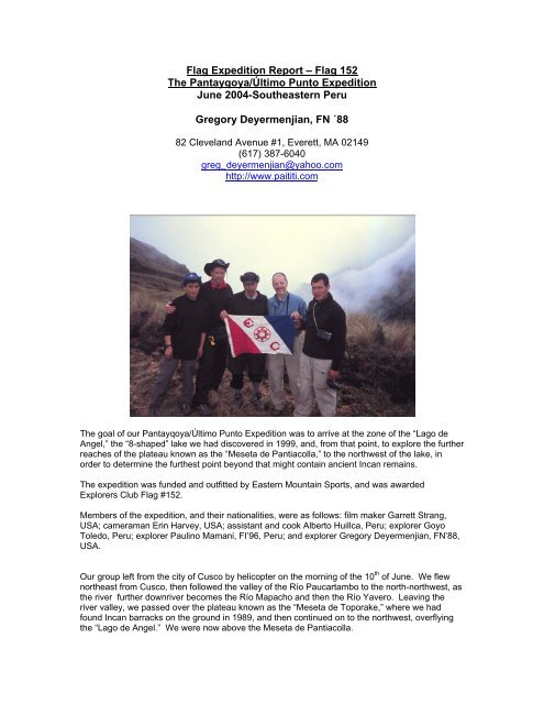
Flag Expedition <strong>Report</strong> – Flag 152<br />
<strong>The</strong> Pantayqoya/Último Punto Expedition<br />
June 2004-Southeastern Peru<br />
Gregory Deyermenjian, FN ´88<br />
82 Cleveland Avenue #1, Everett, MA 02149<br />
(617) 387-6040<br />
greg_deyermenjian@yahoo.com<br />
http://www.paititi.com<br />
<strong>The</strong> goal of our Pantayqoya/Último Punto Expedition was to arrive at the zone of the “Lago de<br />
Angel,” the “8-shaped” lake we had discovered in 1999, and, from that point, to explore the further<br />
reaches of the plateau known as the “Meseta de Pantiacolla,” to the northwest of the lake, in<br />
order to determine the furthest point beyond that might contain ancient Incan remains.<br />
<strong>The</strong> expedition was funded and outfitted by Eastern Mountain Sports, and was awarded<br />
<strong>Explorers</strong> <strong>Club</strong> Flag #152.<br />
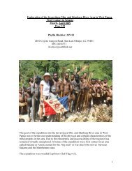
Members of the expedition, and their nationalities, were as follows: film maker Garrett Strang,<br />
USA; cameraman Erin Harvey, USA; assistant and cook Alberto Huillca, Peru; explorer Goyo<br />
Toledo, Peru; explorer Paulino Mamani, FI’96, Peru; and explorer Gregory Deyermenjian, FN’88,<br />
USA.<br />
Our group left from the city of Cusco by helicopter on the morning of the 10 th of June. We flew<br />
northeast from Cusco, then followed the valley of the Río Paucartambo to the north-northwest, as<br />
the river further downriver becomes the Río Mapacho and then the Río Yavero. Leaving the<br />
river valley, we passed over the plateau known as the “Meseta de Toporake,” where we had<br />
found Incan barracks on the ground in 1989, and then continued on to the northwest, overflying<br />
the “Lago de Angel.” We were now above the Meseta de Pantiacolla.
Because of high winds and heavy mist, the helicopter was unable to land near the lake, and had<br />
to search for a suitable landing spot, finally finding a just barely flat-enough area, astride a steep<br />
incline, further to the northwest. We—the six expeditionaries--had to exit the helicopter in a hurry<br />
while the motors remained churning at full blast and the rotors continued to keep the chopper an<br />
inch or so off the soft, soggy ground. After we had jumped to the ground, the many sacks of gear<br />
and supplies were thrown out to us by the helicopter crew from the hovering craft, and we<br />
dragged it all away from the chopper while slipping and sliding in the mud and tall grass, buffeted<br />
by the wind from the turning blades and the chaotic roar of motors and mad shouts, until the pilot<br />
and co-pilot gave us a thumbs-up smile from the cockpit and quickly ascended to zoom off and<br />
leave us in a sudden and complete stillness, with not a sound to be heard in the middle of<br />
nowhere but our labored breathing.<br />
We had more equipment than we could easily carry—even with Paulino and Goyo´s prodigious<br />
strength—but finally we managed to haul all the equipment to the southeast, to make camp to the<br />
west-northwest of where the Lago de Angel was reckoned to be. Our camp´s coördinates were<br />
72 degrees-09 minutes-30 seconds longitude west, by 12 degrees-26 minutes-50 seconds<br />
latitude south. <strong>The</strong> next morning the 11 th of June, we trekked southward, along various portions<br />
of Incan trail, to the Lake of Angel, which lay at 72 degrees-08 minutes-44 seconds longitude<br />
west, by 12 degrees-27 minutes-15 seconds latitude south. After photographing and filming and<br />
documenting anew the low Incan ceremonial platforms that overlook the waters of the lake, and<br />
seeking the caves around the lake in which we had found a triangular monolith five years before,<br />
we returned to camp that same afternoon. With the darkness of night came the intense cold of<br />
“las alturas,” the tundra-like highlands.<br />
We were aware of our being, in a sense, immobile, our being in possession of a surfeit of quality<br />
equipment (including bulky film equipment) without pack animals to help us carry it all in the<br />
rarified air at between 10,500 and 12,000 feet altitude; and so, on the12 th of June our two<br />
strongest members, Paulino and Goyo, left, to quickly head southwest, toward the far-off<br />
settlement of Sacramento in the valley of the Río Yavero, to there seek campesino settlers with<br />
horses or mules, so that we could attain some pack animals to help us move about. Soon after<br />
Paulino´s and Goyo´s leaving, the cold Andean rains came in force. That same afternoon our<br />
satellite phone ceased functioning, making it impossible for us to call in our ongoing reports to the<br />
expedition´s website, and causing those who had been receiving our nightly calls to begin<br />
worrying about us, as we began to worry about them worrying about us. On the 13 th of June the<br />
rains continued, and we waited all day in camp except for making a steep climb that afternoon,<br />
cutting through the cloud-forest that lined the upper reaches of a saddle between two peaks<br />
above our campsite. Finally on the morning of the 14 th , the rains stopped, and we climbed up and<br />
over that same saddle, and cut our way through the thick mantle of moss and vegetative debris<br />
that covered the cloud forest on the other side, looking in vain for any signs of an Incan trail. That<br />
afternoon Paulino and Goyo arrived at camp, and, just before darkness, some campesinos and<br />
their acémilas, pack mules.<br />
Tuesday, the 15 th of June, we were able to now pack all our equipment onto the pack animals as<br />
well as onto our own backs, and we left that campsite, headed northwest and west-northwest,<br />
following the remains of an antique Incan trail that appeared and disappeared on our tortuous<br />
route through these highlands, full of tall windswept grass and plants such as achúpaya, a<br />
cactus-like plant that is food for the spectacled bear, and with bushes and stunted trees in the<br />
various ravines and passes.
We continued our journey to the northwest. In the afternoon we found ourselves resting beside a<br />
moss-and grass-covered mound, while a neblina, a mist, rose from the valleys below and settled<br />
around us. We were at an altitude of 3,500 meters. Paulino inspected the mound beside us,<br />
and, removing some of the vegetative covering, showed it to be a large platform. We cut away at<br />
the high grass and pulled away the moss to reveal a ceremonial platform one meter high. Its<br />
shape was not symmetrical, with one side´s length being 14 meters, another being 11 meters,<br />
and with a width of 4 meters on one side and 3 meters on the other. <strong>The</strong> walls of the platform<br />
were of pirqa, piled field stones, tightly fit together in a dry wall, while the center was composed of<br />
tightly packed earth. It had a small ceremonial staircase of carved stone steps on one side. This<br />
platform was larger and taller, had more volume, and covered more ground than any other of the<br />
many ceremonial platforms we had ever identified in other areas such as Toporake or Lago de<br />
Angel. This was, as well, the only one we had found in these areas that boasted an attached<br />
staircase.
In front of us, up to the northwest, we saw the highest point of the region, a peak that we called<br />
“Último Punto.” We climbed the ridge up to that high point, at an altitude of 3,600 meters, where<br />
we found that the summit was totally covered by another platform, even more asymmetrical in<br />
shape, that had five corners, and was shaped like a squashed bullet, with its point toward the<br />
northeast. This platform was a little shorter than the other, with sides of 10 meters and 9 meters<br />
in length, of 6 meters width on the rear side, and with a wall of 8 meters in length and another of 5<br />
meters meeting at the front to form the “point of the bullet.” It had a height of a little less than one<br />
meter. Its location, at 72 degrees-11 minutes-30 seconds longitude west, by 12 degrees-25<br />
minutes-40 seconds south latitude, overlooked two separate river systems: to the southwest was<br />
the Río Yavero, and to the northeast lay the headwaters of the Río Timpía. Its location seemed<br />
most strategically placed.<br />
We noted that these two platforms constituted the most distant Incan remains yet found directly to<br />
the north of Cusco.<br />
Our return began the next morning, the 16 th of June. We pushed on to the south and southwest,<br />
and we arrived at the settlement of Sacramento, above the sub-tropical Río Yavero, where we<br />
passed the night camped in front of the house of our mule driver, Mario. <strong>The</strong> 17 th of June Paulino<br />
left us early in the morning in order to walk as fast as possible to the town of Quebrada, over the<br />
range of Lares-Lacco in the valley of the Río Yanatile, in order to use the public phone there to<br />
call Cusco and arrange for our vehicle to meet us the following day at the closest frontier point<br />
accessible by dirt road, called Abra Bellavista. <strong>The</strong> rest of us advanced more slowly to the<br />
southwest, crossing a bridge over the Río Yavero, until we reached the small settlement of<br />
Bellavista in the Lares-Lacco range.<br />
<strong>The</strong> next morning, we found a stone chullpa, an above-ground tomb, on a nearby forested<br />
hillside. Its shape was circular, and its stone roof formed by a roughly corbeled vault topped by a<br />
long stone slab. It had a circumference of almost 8 meters, and was in exactly the same style as<br />
the “Chullpas de Ninamarca,” the complex of identical circular tombs to be found in the high area<br />
just south of the famous town of Paucartambo, a totally different area extremely far to our<br />
southeast. And Ninamarca, strangely enough, had been reliably attributed to the pre-Incan<br />
Lupaca culture based in the Lake Titicaca area over a hundred miles away. <strong>The</strong>re were as well<br />
other more typically Incan structures in the surrounding forest.
<strong>The</strong> 18 th of June we headed on, ever southward, along what seemed like an endless and<br />
extremely uncomfortable gauntlet of ascents and descents and ascents again, through the<br />
undulating center of the mountain range, until, just before dark, we were met by Paulino returning<br />
toward us from Quebrada, where he had succeeded in calling the proprietor of our vehicle in<br />
Cusco, and shortly thereafter we all reached Abra Bellavista together. <strong>Here</strong> was the furthest<br />
reach of a newly formed dirt road for vehicles that extended out in redundant zig-zag fashion from<br />
the town of Quebrada, skirting the high mini-range that would otherwise cut the town off from the<br />
area to the north, and here as well was our vehicle. We bid goodbye to our mule driver, Mario,<br />
and rode in style to Quebrada, where we spent the night.<br />
<strong>The</strong> 19 th of June we rode over the bumpy dirt trunk road that follows the course of the Río<br />
Yanatile to the all stone-edifices town of Amparaes, and then up into the highlands to the<br />
northeast to the site of Pumacocha, the lake renowned as that into which the retreating Incans<br />
threw their chuño, their stores of dehydrated potatoes, in order to lighten their load and speed<br />
their way toward their legendary ultimate refuge of “Paititi.” We passed the night in tents by the<br />
lake, then headed on the next morning as far as the road would take us to the east, then walked<br />
through the Quechua-speaking village of Hualla, and on to the site of Tambocancha, an extensive<br />
Incan complex overlooking the valley of the Río<br />
Mapacho-Paucartambo far below to the east. We cleared the dense vegetation from a portion of<br />
the site, to film and photograph it. <strong>The</strong>n we returned to Pumacocha, where Paulino extracted<br />
from its frigid waters some handfuls of preserved chuño, and from thence made the long voyage<br />
in vehicle to arrive late at night in the city of Cusco, ancient capital of the Incas.<br />
<strong>The</strong> principal attainment, then, of <strong>The</strong> Pantayqoya/Último Punto Expedition, was our finding that<br />
there, at the very point where, geographically, lies the furthest edge of the plateau known as the<br />
Meseta de Pantiacolla, are situated as well two very distinct examples of the furthest reach<br />
directly to the north of Cusco of the Incas: the two ceremonial platforms that, up to this point in<br />
time, constitute their “Último Punto,” the ultimate reach in that direction of the Andean world.