Land Mobile Mapping & Survey - Trimble
Land Mobile Mapping & Survey - Trimble
Land Mobile Mapping & Survey - Trimble

Create successful ePaper yourself
Turn your PDF publications into a flip-book with our unique Google optimized e-Paper software.
6<br />
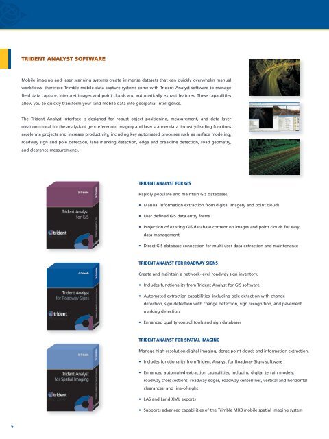
TridenT anaLyST SofTware<br />
<strong>Mobile</strong> imaging and laser scanning systems create immense datasets that can quickly overwhelm manual<br />
workflows, therefore <strong>Trimble</strong> mobile data capture systems come with Trident Analyst software to manage<br />
field data capture, interpret images and point clouds and automatically extract features. These capabilities<br />
allow you to quickly transform your land mobile data into geospatial intelligence.<br />
The Trident Analyst interface is designed for robust object positioning, measurement, and data layer<br />
creation—ideal for the analysis of geo-referenced imagery and laser scanner data. Industry-leading functions<br />
accelerate projects and increase productivity, including key automated processes such as surface modeling,<br />
roadway sign and pole detection, lane marking detection, edge and breakline detection, road geometry,<br />
and clearance measurements.<br />
TriDeNT ANAlyST fOr GiS<br />
Rapidly populate and maintain GIS databases.<br />
• Manual information extraction from digital imagery and point clouds<br />
• User defined GIS data entry forms<br />
• Projection of existing GIS database content on images and point clouds for easy<br />
data management<br />
• Direct GIS database connection for multi-user data extraction and maintenance<br />
TriDeNT ANAlyST fOr rOADwAy SiGNS<br />
Create and maintain a network-level roadway sign inventory.<br />
• Includes functionality from Trident Analyst for GIS software<br />
• Automated extraction capabilities, including pole detection with change<br />
detection, sign detection with change detection, sign recognition, and pavement<br />
marking detection<br />
• Enhanced quality control tools and sign databases<br />
TriDeNT ANAlyST fOr SPATiAl imAGiNG<br />
Manage high-resolution digital imaging, dense point clouds and information extraction.<br />
• Includes functionality from Trident Analyst for Roadway Signs software<br />
• Enhanced automated extraction capabilities, including digital terrain models,<br />
roadway cross sections, roadway edges, roadway centerlines, vertical and horizontal<br />
clearances, and line-of-sight<br />
• LAS and <strong>Land</strong> XML exports<br />
• Supports advanced capabilities of the <strong>Trimble</strong> MX8 mobile spatial imaging system