The Most Comprehensive Solution for Indoor Mapping ... - Trimble
The Most Comprehensive Solution for Indoor Mapping ... - Trimble
The Most Comprehensive Solution for Indoor Mapping ... - Trimble

Create successful ePaper yourself
Turn your PDF publications into a flip-book with our unique Google optimized e-Paper software.
TRIMBLE INDOOR MOBILE MAPPING SOLUTION (TIMMS):<br />
HIGH EFFICIENCY, MAXIMUM FLEXIBILITY, ALL-IN-ONE PACKAGE<br />
Documenting the condition of indoor structures is a necessary but<br />
often times daunting task. Generating detailed indoor models is<br />
critical <strong>for</strong> building life cycle maintenance and the data must be<br />
used by multiple audiences <strong>for</strong> a host of applications including<br />
space optimization, planning renovations, evaluating facility<br />
emergency planning and environmental per<strong>for</strong>mance monitoring<br />
or so called ‘green BIM’ initiatives. Generally, in order to collect<br />
the data <strong>for</strong> such applications the more complex a structure is,<br />
the longer the acquisition and processing time to generate usable<br />
data. This is due in part to the tools available <strong>for</strong> contractors,<br />
namely static LiDAR and spatial imaging systems. <strong>The</strong>se systems,<br />
while precise, require multiple setups and hours to process data in<br />
order to construct accurate representations of 3D interiors.<br />
What is needed is a seamless collection tool which offers precision,<br />
an intuitive workflow which collects 3D LiDAR and 360 spherical<br />
video simultaneously in real world coordinates, and the ability<br />
to create complex 3D models or simple 2D floor plans – all of<br />
which can be collected at walking speeds and presented in a web<br />
interface <strong>for</strong> rapid visualization and dissemination to a variety of<br />
users. <strong>The</strong>se capabilities are available with TIMMS, the industry’s<br />
first and only all-in-one solution <strong>for</strong> indoor mapping.<br />
THE CompLETE SoLuTIoN<br />
TIMMS is the optimal fusion of technologies <strong>for</strong> capturing spatial<br />
data <strong>for</strong> indoor and other GNSS denied areas of all sizes and<br />
locations. It provides both LiDAR and spherical video of a facility,<br />
enabling the creation of accurate, real-life representations of an<br />
interior space and all of its contents. <strong>The</strong> maps created are geolocated,<br />
meaning that the real world positions of each area of<br />
the building and its contents are known. Each pixel from the<br />
camera system and every point from the LiDAR have a latitude,<br />
longitude and elevation associated with it without the need of any<br />
external infrastructure to provide positioning in<strong>for</strong>mation – TIMMS<br />
is totally self contained. Utilizing inertial technology and powerful<br />
processing software, TIMMS can be initialized immediately and<br />
can per<strong>for</strong>m wide area mapping of a facility <strong>for</strong> extended periods<br />
of time. For the user, this means less time setting up equipment<br />
and more productivity, while ensuring consistent accuracy. Once<br />
the data is processed, the resulting spatial data can be rendered in<br />
a 360º panoramic viewer, allowing the user to be fully immersed in<br />
the interior space, able to zoom, pan and measure items of interest<br />
as desired.<br />
Because of its tremendous efficiency and speed, TIMMS is very<br />
effective even <strong>for</strong> facilities extending over several city blocks. This<br />
allows the user to obtain holistic 3D indoor geospatial views of all<br />
kinds of infrastructure including:<br />
• Plant and factory facilities<br />
• High-rise office, residential, and government buildings<br />
• Airports, train stations and other transportation facilities<br />
• Music halls, theatres, auditoriums and other public event<br />
spaces<br />
• Covered pedestrian concourses (above and below ground) with<br />
plat<strong>for</strong>ms, corridors, stair locations and ramps<br />
• Underground mines and tunnels<br />
TImmS DELIVErS A rEVoLuTIoN IN FACILITIES<br />
mANAGEmENT<br />
Until now, professionals involved in Building In<strong>for</strong>mation<br />
Modelling (BIM) had a choice: acquire quick but limited 2D data<br />
(floor plans) of interiors and interior structures, or acquire more<br />
detailed but also more time-consuming 3D LiDAR data. TIMMS<br />
eliminates this unnecessary compromise by doing both at the same<br />
time; all in a single pass, at low cost, with high accuracy.<br />
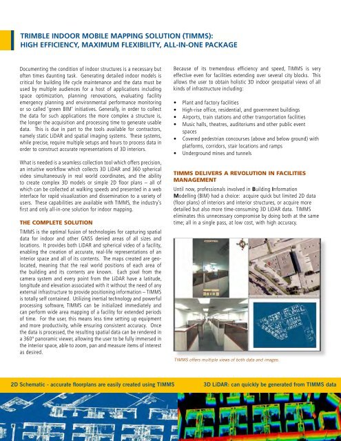
TIMMS offers multiple views of both data and images.<br />
2D Schematic - accurate floorplans are easily created using TIMMS 3D LiDAR: can quickly be generated from TIMMS data