The Most Comprehensive Solution for Indoor Mapping ... - Trimble
The Most Comprehensive Solution for Indoor Mapping ... - Trimble
The Most Comprehensive Solution for Indoor Mapping ... - Trimble

You also want an ePaper? Increase the reach of your titles
YUMPU automatically turns print PDFs into web optimized ePapers that Google loves.
TECHNICAL ADVANTAGES<br />
TIMMS offers significant technical advantages over<br />
other methods <strong>for</strong> indoor mapping:<br />
• Little or no LiDAR shadowing: being<br />
mobile allows TIMMS to move in and around<br />
structures. Static methods require multiple<br />
setups to capture the same level of data,<br />
increasing costs<br />
• Extended range of operations: no<br />
need <strong>for</strong> frequent stops to re-calibrate<br />
• Able to start mission anywhere…<br />
indoors or out, no need <strong>for</strong> GNSS. TIMMS<br />
is self contained utilizing industry leading<br />
inertial technology which provides reliable and<br />
repeatable high accuracy over long duration<br />
missions<br />
• Simple workflow: utilize POSPac MMS to<br />
derive the georeferenced point cloud of the<br />
structure in addition to the spherical video.<br />
Upload to <strong>Trimble</strong>’s Connected Community<br />
(TCC) anywhere in the world, where users can<br />
share, visualize and analyze the data quickly<br />
and efficiently using a standard web browser<br />
• Long battery life: offering extended<br />
range of operation<br />
• Extended modeling capabilities with<br />
any third party software which utilizes 2D or<br />
3D LiDAR data<br />
• Fully Customizable: another industry<br />
first – TIMMS can be adapted with custom<br />
hardware and software to meet your specific<br />
needs<br />
• Per<strong>for</strong>m wide area mapping with<br />
the ability to layer in multiple types of data<br />
(e.g. pipes, mechanical) using static scanners,<br />
providing a truly holistic model with multiple<br />
levels of detail<br />
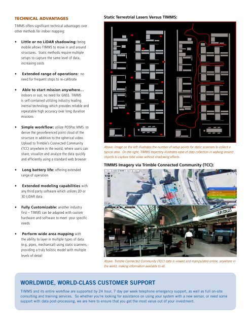
Static Terrestrial Lasers Versus TIMMS:<br />
WORLDWIDE, WORLD-CLASS CUSTOMER SUPPORT<br />
Above: Image on the left illustrates the number of setup points <strong>for</strong> static scanners to collect a<br />
typical area. On the right, TIMMS trajectory illustrates ease of data collection in walking around<br />
objects to capture total views without shadowing effects.<br />
TIMMS Imagery via <strong>Trimble</strong> Connected Community (TCC):<br />
Above: <strong>Trimble</strong> Connected Community (TCC) data is viewed and manipulated online, anywhere in<br />
the world, making in<strong>for</strong>mation available to all.<br />
TIMMS and its entire workflow are supported by 24 hour, 7 day per week telephone emergency support, as well as full on-site<br />
consulting and training services. So whether you’re looking <strong>for</strong> assistance on using your system with a new sensor, or need some<br />
support with data post-processing, we are here to ensure that you get the most value out of your investment.