The Nanga Parbat-Haramosh Monitoring Network - IRSA - Cnr
The Nanga Parbat-Haramosh Monitoring Network - IRSA - Cnr
The Nanga Parbat-Haramosh Monitoring Network - IRSA - Cnr

You also want an ePaper? Increase the reach of your titles
YUMPU automatically turns print PDFs into web optimized ePapers that Google loves.
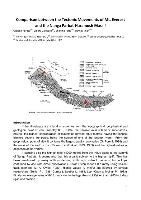
Comparison between the Tectonic Movements of Mt. Everest<br />
and the <strong>Nanga</strong> <strong>Parbat</strong>-<strong>Haramosh</strong> Massif<br />
Giorgio Poretti (1) , Chiara Calligaris (2) , Shahina Tariq (3) , Hawas Khan (4)<br />
(1) University of Trieste, Italy – DMI, (2) University of Trieste, Italy – DiSGAM, (3) Bahria University, Pakistan - DE&ES<br />
(4) Karakorum International University, Gilgit – DES<br />
Introduction<br />
If the Himalayas are a land of extremes from the topographical, geophysical and<br />
geological point of view (Windley B.F., 1986), the Karakorum is a land of superlatives,<br />
having the highest concentration of mountains beyond 8000 metres, having the longest<br />
glaciers beyond the poles, being the source of one of the longest rivers. From the<br />
geophysical point of view it contains the largest gravity anomalies (G. Poretti, 1998) and<br />
thickness of the earth crust (75 km) (Finetti & al. 1979, 1983) and the highest values of<br />
deflection of the vertical.<br />
It contains also the highest relief (4000 metres from the Indus plains to the summit<br />
of <strong>Nanga</strong> <strong>Parbat</strong>). It seems also that this area is subject to the highest uplift. This has<br />
been mentioned by many authors deriving it through indirect methods, but not yet<br />
confirmed by accurate direct observations. Lewis Owen reports 0.7 mm/y using fissiontrack<br />
methods (L. A. Owen, 1989). Higher values (2 mm/y) are inferred by several<br />
researchers (Zeitler P., 1985; Gorniz & Seeber L. 1981; Lyon-Caen & Molnar P., 1983).<br />
Finally an average value of 6-10 mm/y was in the hypothesis of Zeitler & al. 1985 including<br />
uplift and erosion.<br />
1
<strong>The</strong> present study presents the preliminary results of a first survey consequent to<br />
the recent installation (2009) of GNSS network including three permanent GNSS stations<br />
between Islamabad and the Northern Areas of Pakistan and four points located on the<br />
<strong>Nanga</strong> <strong>Parbat</strong> – <strong>Haramosh</strong> massif.<br />
Since a permanent GPS station was located near the Pyramid Laboratory at<br />
Lobuche in the Khumbu region in 1994 providing long records of data during the last 15<br />
years, the goal of the project is to compare data obtained from Everest with the ones from<br />
<strong>Nanga</strong> <strong>Parbat</strong> in order to evaluate, not only the total uplift (if quantifiable) of the two<br />
massifs, but also the direction of the crustal movements.<br />
Regional Geology and Plate Tectonic Setting<br />
Northern Pakistan comprises three former distinct and previously apart plates<br />
named Karakoram, Kohistan and Indian. <strong>The</strong>se Plates collided with each other during<br />
Cretaceous-Tertiary ages and formed the present day configuration of this region<br />
(Tahirkheli et al., 1982; Coward et al., 1987). This collisional tectonics and mountainbuilding<br />
activity is termed Himalayan orgogeny being the result of continent-arc-continent<br />
collision. <strong>The</strong> Kohistan Island Arc is sutured to the Karakoram Block (Shyok Suture) in the<br />
north along MKT (Main Karakoram Thrust) and to the Indian Plate (Indus-Tsangpo Suture)<br />
in the south. <strong>The</strong> tectonics of Kohistan is related to collisional tectonics of Hindu Kush,<br />
Karakoram and Himalayan Ranges which involve Indian Plate with <strong>Nanga</strong> <strong>Parbat</strong>-<br />
<strong>Haramosh</strong> Massif, Karakoram Block and in between sandwiched Kohistan Arc.<br />
Geology of the <strong>Nanga</strong> <strong>Parbat</strong> area<br />
<strong>Nanga</strong> <strong>Parbat</strong>–<strong>Haramosh</strong> massif is delimitated by two thrust-displacement shear<br />
zones that have a spatial and temporal link with granite plutonism from ca. 10 to 1 Ma. <strong>The</strong><br />
shear zones define a crustal-scale antiformal pop-up structure, with dominant westnorthwest–vergent<br />
and subordinate east-southeast–vergent thrusting. This is substantially<br />
different than the surrounding area where the main exposed Himalayan structures are<br />
oriented parallel to the orogenic trend and are early to middle Miocene or older (Schneider<br />
et al., 1997). <strong>The</strong> western Himalaya syntaxis includes the <strong>Nanga</strong> <strong>Parbat</strong>–<strong>Haramosh</strong><br />
massif, a now exposed section of largely Proterozoic Indian plate crust, initially<br />
overthrusted by Cretaceous island arc rocks along the Main Mantle thrust. <strong>Nanga</strong> <strong>Parbat</strong> is<br />
an area of extreme relief that has undergone rapid exhumation since 10 Ma (e.g., Zeitler<br />
P., 1985), exposing migmatites and granulitegrade rocks at the core of the massif (Smith<br />
H.A. et al., 1992). <strong>Nanga</strong> <strong>Parbat</strong> syntaxis comprises three major rock units: a) Iskhere-<br />
Mushkin-Rupal Gneiss; b) Shengus-Harchu Gneiss; and <strong>Haramosh</strong>-Tarshing Schists. A<br />
wide range of rocks intruding these major lithological units has been noticed in nearly all of<br />
<strong>Nanga</strong> <strong>Parbat</strong> synaxial region, which included basic dykes and a wide variety of granites.<br />
<strong>The</strong> younger phases of granite up to 0.75 Ma are intruding the <strong>Nanga</strong> <strong>Parbat</strong> Gneisses.<br />
<strong>The</strong> survey of the Mt. Everest mountain range<br />
Fifteen years (unfortunately not continuous) of observations with a permanent GPS<br />
station at the Ev-K2-CNR Pyramid Laboratory allow to determine the precise direction of<br />
the tectonic movement of the Mt. Everest area. Taking into account several time intervals<br />
2
linking to the permanent GNSS station in Lhasa, the shift of the point was computed to be<br />
of 4.2-4.5 cm/year (Poretti G., 1998) to the North-East with an azimuth of approximately<br />
45°.<br />
A research project carried out between June 2009 and November 2010 is trying to<br />
find out the uplift and the direction of the movement of the <strong>Nanga</strong> <strong>Parbat</strong> area with the<br />
installation of three permanent GPS stations (Islamabad, Gilgit and Skardu) that will be remeasured<br />
every year for the next five years.<br />
Conclusions<br />
<strong>The</strong> aim of the project is to evaluate the variation in elevation and direction of the<br />
<strong>Nanga</strong> <strong>Parbat</strong> massif and to compare these results with those obtained from Everest in<br />
order to understand if their movements can be correlated in amount and direction. After<br />
only one year it is seems that the movement of the <strong>Nanga</strong> <strong>Parbat</strong> area is more bended to<br />
the East, but it is still too early to draw conclusions that are not within the margin of error of<br />
the instruments employed. More reliable results will be obtained from the repeated<br />
observations during the next 2-3 years.<br />
<strong>Nanga</strong> <strong>Parbat</strong> from the Rama Bungalow Mt. Everest from Rongbuck<br />
References<br />
1. Gansser, A., 1964. Geology of the Himalayas. Wiley Interscience, London. 289 p., & 4 plates.<br />
2. Finetti I., F. Giorgetti, G. Poretti, 1979, <strong>The</strong> Pakistani segment of the DSS Profile <strong>Nanga</strong> <strong>Parbat</strong>-Karakul (1974-<br />
1975). Bollettino di Geofisica Teorica e Applicata, v. XXI, n. 83, pp. 159-171.<br />
3. Seeber L. & V. Gormiz, 1981. River profiles along the Himalayan arc as indicators of active tectonics.<br />
Tectonophysics<br />
4. Tahirkheli, R. A., 1982. Geology of the Himalaya, Karakoram, Hindukush in Pakistan. Geol. Bull. Univ. Peshawar.<br />
5. Finetti I., G. Poretti, M. A. Mirza, 1983, Crustal Structure of the Karakorum Range along the DSS Profile <strong>Nanga</strong><br />
<strong>Parbat</strong>-Karakul. Bollettino di Geofisica Teorica e Applicata, v. XXV, n. 99-100, pp. 195-205.<br />
6. Ebblin C., A. Marussi, G. Poretti, M. Rahim, P. Richardus, 1983, Gravity Measurements in the Karakorum.<br />
Bollettino di Geofisica Teorica e Applicata, v. XXV, n. 99-100, pp. 303-316.<br />
7. Lyon-Caen H. P. Molnar 1983, Constraints on the structure of the Himalaya from an analysis of gravityanomalies<br />
and a flexural model of the lithosphere. Jornal of Geophys. Research, v. 88(NB10), pp. 8171-8191.<br />
8. Windley B. F., 1986, <strong>The</strong> evolving Continents. J. Wiley & Sons, NY, 400 p.<br />
9. Zeitler, P.K., 1985, Cooling history of the NW Himalaya, Pakistan. Tectonics. v. 4, pp. 127-151.<br />
10. Coward, M.P., Butler, R. W. H., Khan, M. A. & Knippe, R. J., 1987. <strong>The</strong> tectonic history of Kohistan and its<br />
implications for Himalayan structure. Journal of the Geol. Soc. London, v. 144, pp. 377-391.<br />
3
11. Owen, L.A., 1989, Neotectonics and glacial deformation in the Karakoram Mountains and <strong>Nanga</strong> <strong>Parbat</strong><br />
Himalaya. Tectonophysics, v. 163, pp. 277-265.<br />
12. Smith, H.A., Chamberlain, C.P. & Zeitler, P.K., 1992, Documentation of Neogene regional metamorphism in the<br />
Himalayas of Pakistan using U-Pb in monazite. Earth and Planetary Science Letters, v. 113, pp. 93-105.<br />
13. Schneider, D. A., Edwards, M. A., Zeitler, P. K., and Kidd, W. S. F., 1997, Ion microprobe U-(Th)-Pb and Ar/Ar<br />
geochronology of <strong>Nanga</strong> <strong>Parbat</strong> - <strong>Haramosh</strong> Massif (part 1). Rupal Valley, southern <strong>Nanga</strong> <strong>Parbat</strong>, and Jutial<br />
granite, <strong>Haramosh</strong> area. in Angiolini, L., et al. eds., 12th Himalaya-Karakoram-Tibet Workshop - Abstract<br />
Volume, Accademia Nazionale dei Lincei., pp. 205-206.<br />
14. Poretti G., 1998. Geophysical, Geological and Geographycal features of the Himalayas. Ecovision World<br />
Monograph Series, Backhuys Publishers, Leiden, pp.19-34.<br />
15. Poretti, G., Calligaris, C., Tariq, S., Khan, H., Zubair, F., & Mereu A., 2009, <strong>The</strong> <strong>Monitoring</strong> of the <strong>Nanga</strong> <strong>Parbat</strong>-<br />
<strong>Haramosh</strong> Massif. GNGTS Conference, Trieste, Italy, 16-19 November, 2009.<br />
16. Poretti, G., C. Calligaris, Tariq S., Khan H., Zubair F., and De Min, G., 2010. Geological, Geophysical and<br />
Topographic Measurements in the Diamer Basha Dam Area. European Geosciences Union General Assembly<br />
2010, Vienna, Austria, 2-7 May 2010, (Abstract volume)<br />
Key words: <strong>Nanga</strong> <strong>Parbat</strong>, GNSS net<br />
4