
Create successful ePaper yourself
Turn your PDF publications into a flip-book with our unique Google optimized e-Paper software.
Oakie Trail, S½NE¼ sec. 15, T. 40 N., R. 88<br />
W., Northwestern Natrona County<br />
The Flathead Sandstone <strong>in</strong> this area conta<strong>in</strong>s up to<br />
134 ppm thorium, but less than 5 ppm uranium,<br />
and is likely a typical Flathead Sandstone paleoplacer<br />
(Malan, 1972). The Flathead here consists<br />
of white to red, quartz pebble conglomerate and<br />
medium- to coarse-gra<strong>in</strong>ed, poorly sorted, subrounded,<br />
iron-rich subarkose, with coarse weathered<br />
limonite gra<strong>in</strong>s (Sample 20121017JC-E).<br />
In places where the Flathead Sandstone is weakly<br />
brecciated (Sample 20121017JC-F), no elevated<br />
REE or thorium values were detected.<br />
Mesaverde formation Paleoplacers<br />
Titaniferous black sandstone horizons are relatively<br />
common <strong>in</strong> the lower part of the Late Cretaceous<br />
Mesaverde Formation across Wyom<strong>in</strong>g, Colorado,<br />
and New Mexico, and <strong>in</strong> the Mesaverde Group<br />
<strong>in</strong> Arizona (Houston and Murphy, 1962; 1970).<br />
The Wyom<strong>in</strong>g deposits (fig. 13) occur at the top<br />
of the formation’s basal sandstone (Houston and<br />
Murphy, 1962). The host<strong>in</strong>g basal sandstone of the<br />
Mesaverde is typically a tan to buff, f<strong>in</strong>e-gra<strong>in</strong>ed<br />
sandstone overla<strong>in</strong> by a succession of <strong>in</strong>terbedded<br />
sandstone, shale, carbonaceous shale, and coal<br />
or, <strong>in</strong> some areas, by black shale. The Mesaverde<br />
Formation is underla<strong>in</strong> by black shale of the Cretaceous<br />
Cody Shale. Together, the Cody and the<br />
Mesaverde represent a generally regressive sequence<br />
that transitioned from a deep mar<strong>in</strong>e to near-shore<br />
terrestrial environment over the depositional history<br />
of the two units. The black shale that <strong>in</strong> places<br />
overlies the basal sandstone of the Mesaverde represents<br />
a short-lived transgressive event (Houston and<br />
Murphy, 1962). Titaniferous black sandstones at or<br />
near the top of the basal sandstone are thought to<br />
be fossil beach placers analogous to modern heavy<br />
m<strong>in</strong>eral-rich black sand beaches found <strong>in</strong> Australia<br />
(Houston and Murphy, 1962; 1970).<br />
The heavy m<strong>in</strong>erals with<strong>in</strong> the titaniferous black<br />
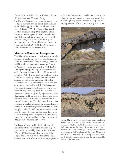
sandstones of the Mesaverde Formation (fig. 17)<br />
were studied <strong>in</strong> detail by Houston and Murphy<br />
(1962; 1970) and are dom<strong>in</strong>antly volcanic <strong>in</strong><br />
orig<strong>in</strong>. The heavy m<strong>in</strong>eral fraction of the black<br />
sandstone consists of 79 to 97 percent opaque m<strong>in</strong>-<br />
erals, mostly iron-titanium oxides, but a radioactive<br />
niobium-bear<strong>in</strong>g m<strong>in</strong>eral may also be present. The<br />
rema<strong>in</strong><strong>in</strong>g heavy m<strong>in</strong>eral fraction is composed of<br />
vary<strong>in</strong>g amounts of zircon, monazite, garnet, rutile,<br />
figure 17. Outcrops of titaniferous black sandstone<br />
with<strong>in</strong> the Cretaceous Mesaverde Formation. A,<br />
outcrop at Mud Creek, black sandstone overlies tan to<br />
buff sandstone of the lower Mesaverde, view is to the<br />
northeast. B, outcrop at Dugout Creek, black sandstone<br />
overlies tan to buff sandstone of the lower Mesaverde,<br />
view is to the northwest. C, outcrop at Grass Creek,<br />
north deposit, black sandstone is at the top of the cliff,<br />
view is to the northeast.<br />
48