Pembrokeshire and Ceredigion Rivers Catchment Flood ...
Pembrokeshire and Ceredigion Rivers Catchment Flood ...
Pembrokeshire and Ceredigion Rivers Catchment Flood ...

Create successful ePaper yourself
Turn your PDF publications into a flip-book with our unique Google optimized e-Paper software.
Future direction for flood<br />
risk management<br />
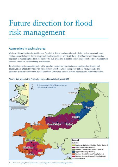
Approaches in each sub-area<br />
We have divided the <strong>Pembrokeshire</strong> <strong>and</strong> <strong>Ceredigion</strong> <strong>Rivers</strong> catchment into six distinct sub-areas which have<br />
similar physical characteristics, sources of flooding <strong>and</strong> level of risk. We have identified the most appropriate<br />
approach to managing flood risk for each of the sub-areas <strong>and</strong> allocated one of six generic flood risk management<br />
policies. These are shown in Map 3 <strong>and</strong> Table 5.<br />
To select the most appropriate policy, the plan has considered how social, economic <strong>and</strong> environmental<br />
objectives are affected by flood risk management activities under each policy option. Policy analysis <strong>and</strong><br />
selection is based on flood risk across the entire CFMP area <strong>and</strong> not just the key locations referred to earlier.<br />
Map 3. Sub-areas in the <strong>Pembrokeshire</strong> <strong>and</strong> <strong>Ceredigion</strong> <strong>Rivers</strong> CFMP<br />
© Crown copyright 2009. All rights reserved.<br />
Licence number 100026380<br />
12 Environment Agency Wales <strong>Pembrokeshire</strong> <strong>and</strong> <strong>Ceredigion</strong> <strong>Rivers</strong> <strong>Catchment</strong> <strong>Flood</strong> Management Plan