

Saxon Southampton; a New Review - Archaeology Data Service
Saxon Southampton; a New Review - Archaeology Data Service
Saxon Southampton; a New Review - Archaeology Data Service

Create successful ePaper yourself
Turn your PDF publications into a flip-book with our unique Google optimized e-Paper software.
<strong>Saxon</strong> <strong>Southampton</strong>; a <strong>New</strong> <strong>Review</strong><br />
By PHILIP HOLDSWORTH<br />
Director, <strong>Southampton</strong> Archaeological Research Committee<br />
THE LA TE SEVENTH to earfJ roth-century town and international port of <strong>Saxon</strong><br />
<strong>Southampton</strong> is reconsidered in the light of recent archaeological excavations. A lagoon,<br />
previousfJ believed to have been a primary reason for the siting of the port, is shown not to<br />
have been a topographical feature of the town. A number of timber buildings was found<br />
which included oblong structures with the wall posts set in continuous trenches, one of which<br />
had an additional room erected on ground sills. Two bow-sided buildings are described and<br />
discussed. Some of the possible functions of a shallow wood-lined pit with corner posts are<br />
suggested, and a keyhole-shaped iron-smelting furnace and bowl hearth are described. The<br />
areas oftrading contact and the town's status are considered.<br />
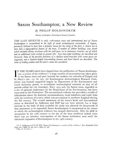
IN THE YEARS which have elapsed since the publication of'<strong>Saxon</strong> <strong>Southampton</strong>:<br />
a review of the evidence'," a large number of excavations has taken place<br />
in the <strong>Saxon</strong> town and port beneath the modern city suburbs of Chapel and<br />
St Mary's (FIG. 10). In 1971 the <strong>Southampton</strong> Archaeological Research Committee<br />
was formed, supported largely by Department of the Environment and<br />
Local Authority grants, to co-ordinate archaeological research on sites of all<br />
periods within the city boundary. Since 1974 only the <strong>Saxon</strong> town, regarded as<br />
a site of national importance by the Department of the Environment, has been<br />
excavated by the Committee. The accumulated evidence has provided a wealth of<br />
information about the domestic accommodation, local industries and trade links<br />
with the continent of a town which was pre-eminent in southern England during<br />
the 8th century. The overall assessment of the town's local and international<br />
status as described by Addyman and Hil12 has not been altered, but a large<br />
increase in the body of data available for study has allowed the framework of<br />
that assessment to be expanded. <strong>Saxon</strong> <strong>Southampton</strong> is exceptional in the extent<br />
to which the archaeological evidence has escaped destruction. After the shift in<br />
occupation in the roth century to the site of the later medieval walled town<br />
there was no intensive reoccupation of the <strong>Saxon</strong> settlement area until the<br />
industrial expansion of <strong>Southampton</strong> in the 19th century.<br />
1 P. V. Addyman and D. H. Hill, '<strong>Saxon</strong> <strong>Southampton</strong>: a review of the evidence', Proc. Hampshire Field<br />
Club, xxv (1968),61-93; XXVI (1969), 61-96.<br />
2 Op. cit. in note I.
21<br />
SAXON SOUTHAMPTON<br />
100m<br />
I<br />
1<br />
300 yds.<br />
FIG. IO<br />
St. Mary's <strong>Southampton</strong><br />
\<br />
I \<br />
1\\<br />
:s',:-._<br />
I '<br />
I<br />
I<br />
I<br />
I<br />
I<br />
I<br />
I<br />
I<br />
I<br />
I<br />
N<br />
t<br />
EXCAVATIONS IN HAMWIH, SOUTI-lA:\lPTON<br />
EXCAVATIONS &<br />
OBSERVATIONS<br />
1825 - 1976<br />
Sites with Arabic numerals excavated before 1972; those with Roman numerals arc S.A.R.C. sites.<br />
On sites without numbers no archaeological excavations took place, although observations were<br />
made during building work
LOCATION (FIG. I I)<br />
SAXON SOUTHAMPTON<br />
The <strong>Saxon</strong> town is sited on the W. bank of the R. Itchen, on a promontory<br />
between the R. Itchen and R. Test (FIG. I I), bounded to the S. by marshland<br />
and to the N. and W. by a gravel ridge. The reason for the founding of the<br />
settlement on the low lying flats of brickearth, rather than on higher, more<br />
defensible ground to the W., has been explained in the past by the presence of a<br />
lagoon in the <strong>Saxon</strong> period. This lagoon was first postulated by O. G. S. Crawford,"<br />
and he believed it to have been formed by the extension of the I tchen<br />
mouth shingle spit. It would have formed "a small natural harbour protected<br />
from the open sea". Later Addyman and Hill! described sediments located at<br />
Sites 25 and 26 (FIG. 10) as "presumably lagoonal silts" and "fine apparently<br />
waterlain silts above gravel". A recent analysis of the sediments has shown the<br />
brickearth to be a redeposited loess, none of the samples remotely resembling<br />
lagoonal deposits." The samples taken for analysis came from widely spaced areas,<br />
three of them from locations within the supposed lagoon which also produced<br />
evidence of occupation. Interestingly, samples collected immediately E. of Site 25<br />
were markedly different from the other sediments analysed. These have been<br />
interpreted as indicating conditions similar to those of a tidal creek, but not an<br />
open beaeh or strongly tidal estuary. A small creek was recorded in this vicinity<br />
by a detachment ofthe Royal Sappers in 1845-6 when examining the area with a<br />
view to land reclamation.<br />
It would seem, therefore, that a lagoon did not exist in the area suggested by<br />
Crawford. However, an indented shore-line would still have received some<br />
protection from the open sea by the Itchen shingle spit and have afforded an<br />
attractive natural harbour.<br />
Land reclamation and the canalization of the river have always precluded<br />
excavation along the <strong>Saxon</strong> shore-line. However, the redevelopment of an area<br />
close by the Itchen shingle spit in 1976-7 may afford the opportunity for such<br />
investigation.<br />
HAMWIH AND HAMTUN<br />
The name of the settlement has been a subject of much debate amongst<br />
archaeologists, philologists and local historians. It is recorded separately as<br />
Hamwih and Hamtun (and their variants) in documents and on coins from the<br />
8th to the r rth century. Burgess" has proposed two distinct sites, a fortified<br />
centre, Hamtun, and a mercantile settlement, Hamwih. His argument, based on<br />
place-name evidence, is that the element wih, or wic, always refers to the suburb<br />
of an earlier defended site, the tun. The evidence is not, however, consistent, for a<br />
number of commercial centres in England possess the element wic, such as<br />
Norwich and Sandwich. Furthermore, despite extensive excavation and careful<br />
3 O. G. S. Crawford, 'Trinity Chapel and Fair', Proc. Hampshire Field Club, XVII (1949),45.<br />
4 Op, cit. in note I, XXV, 75.<br />
5 See M. Shackley in D. A. Hinton (cd.), <strong>Saxon</strong> <strong>Southampton</strong>: Excavations in Melbourne Street [.97[-1<br />
(forthcoming) .<br />
6 L. A. Burgess, The Origins of<strong>Southampton</strong> (Leicester, 1964).
PHILIP HOLDSWORTH<br />
observations during development in <strong>Southampton</strong>, no signs of defences earlier<br />
than the loth century have been discovered. If there were two separate settlements<br />
in <strong>Southampton</strong> it is somewhat surprising that only one has been located.<br />
Hamtun, if it existed as an entity, must have been of considerable size, for by 755<br />
it had given its name to the shire," and was used as the mint name on coins well<br />
into the r rth ceritury."<br />
More recently, Miss J. ]enkyns and A. Rumble have suggested that the two<br />
names may refer to the same locale, and that alternative spellings may be accounted<br />
for by the context in which <strong>Saxon</strong> <strong>Southampton</strong> was being referred to."<br />
A mid 9th-century royal charter signed in the "villa regalis quae appellatur Hamptone"10<br />
clearly indicates there was a royal residence at Hamtun. An area known<br />
today as Kingsland, on the NW. edge of Hamwih, was certainly in possession of<br />
the king by the r zth century;"! if the villa regalis given in the charter was on the<br />
same site, then Hamtun and Hamwih may have been physically part of the same<br />
general area whilst retaining their separate identities.<br />
Whatever the uncertainties may be about the two sites, excavations in the<br />
Chapel and St Mary's areas have firmly established the location ofan undefended<br />
merchants' settlement. For this reason the site will continue to be referred to as<br />
Hamwih. Evidence of occupation, of trade and of industry has been found over<br />
an area of more than 32 hectares. Although not all this area would necessarily<br />
have been occupied at the same time, Hamwih was probably the largest denselypopulated<br />
town in 8th-century England. Furthermore, unlike the contemporary<br />
sites of York, Canterbury and London, Hamwih did not develop from an earlier<br />
Roman settlement. Whether it developed from a nucleation of scattered riverside<br />
communities, or as the direct result of a deliberate policy in the late 7th century is<br />
unknown; but by 721, when the first documentary reference to Hamwih occurs.l''<br />
it was clearly an established and flourishing international port, a 'mercimonia'<br />
ranking with Dorestad and Quentovic.<br />
LIFE AND LIVELIHOOD<br />
The elucidation of the archaeology of Hamwih has always been beset with<br />
problems. These have been mainly the recognition and isolation of coherent<br />
structural plans and the establishment of an internal chronological sequence on<br />
sites devoid of stratification. Improved excavation and meticulous recording<br />
techniques have largely solved the former, although no complete structural plans<br />
have yet been recovered like those at Chalton 13 or Catholme.P Recent researches<br />
7 G. N. Garmonsway (trans.), Anglo-<strong>Saxon</strong> Chronicle (London, 1953).<br />
8 Op. cit. in note I, xxv, 78.<br />
9 I am grateful to Joy Jenkyns and Alex Rumble for permission to include their findings in advance of<br />
publication.<br />
10 P. H. Sawyer, Anglo-<strong>Saxon</strong> Charters: An Annotated List and Bibliography (London, 1968), no. 288.<br />
11 J. S. Davies, History of<strong>Southampton</strong> (<strong>Southampton</strong>, 1883) 32,41.<br />
12 O. Golder-Egger (ed.), 'Vita Willibaldi Episcopi Eichstentetensis', Mon. Germ. Hist. Scriptorum, xv,<br />
pt. i (Hanover, 1887),91.<br />
13 P. V. Addyman, 'Anglo-<strong>Saxon</strong> houses at Chalton, Hampshire', Medieval Archaeol., XVI (1972), 13-31.<br />
I< Current <strong>Archaeology</strong>, v, ii (no. 49) (March, 1975),53.
N<br />
t<br />
lL<br />
SAXON SOUTHAMPTON 3 1<br />
into the pottery and glass, combined with the coin evidence and an increasing<br />
number of radio-carbon dates, are promising a solution to the latter.<br />
BUILDINGS (FIGS. 12-17)<br />
Building I (FIG. 12). The partial ground plan of this structure, which lay S. ofa<br />
gravel-surfaced road running E. and W., had been extensively destroyed by later<br />
disturbance. Only a part of the N. wall, aligned parallel with the road, and a<br />
number ofinternal partitions had survived. The outer wall had closely set stakeholes<br />
within a continuous bedding trench, which was interrupted by an entrance<br />
flanked by substantial post-holes. This doorway gave direct access on to the road.<br />
The internal dividing walls showed a variation of constructional techniques, in<br />
which wattle panels were set between groups of stake-holes in both continuous<br />
and irregularly spaced trenches, and possibly even on sill beams. The structure<br />
was of at least two main phases. In the first, the entrance was 2.38 m , wide with a<br />
dividing wall set roughly at right angles to the eastern doorpost. In the second<br />
phase the outer wall was completely replaced, and the entrance was narrowed to<br />
1.60 m. by the insertion of post-hole FIOI, with a new dividing wall aligned on it.<br />
This second-phase dividing wall had been strengthened by an additional wattle<br />
""<br />
;.<br />
FIG. 12<br />
HAMWIH, SOUTHAMPTON, BUILDING I<br />
Q<br />
MELBOURNE ST. VI<br />
Large structure with internal subdivisions fronting on to gravel-surfaced road. Features<br />
earlier than road have been omitted
PHILIP HOLDSWORTH<br />
panel, 2 m. in length, on the E. side, just inside the entrance. The need for such a<br />
strengthening might have arisen if an inward opening door had been hinged on a<br />
post in hole F I a I. The length of the building is difficult to estimate, but, if the<br />
entrance was placed centrally in the long side, then the length would have been<br />
about 20 m.<br />
Building 2 (FIG. 13). Building 2, a roughly rectangular structure, lay N. of the<br />
road and opposite Building I. The surviving lengths of the S. and E. wall-lines<br />
were of closely spaced stake-holes, in this instance not always within a bedding<br />
trench. The N. wall-line was destroyed by later disturbance. The evidence for the<br />
W. wall consisted ofa number ofdeeply set post-holes within a continuous trench.<br />
This bedding trench stopped 1.50 m. short of the S. wall-line, which extended<br />
beyond the building for 1.60 m. until it was covered by the baulk. The extension<br />
of the S. wall-line is clearly an additional element of the ground plan, but the<br />
absence ofa corner post at the angle ofthe S. and W. walls suggests that the deeply<br />
set post-holes may run across the centre ofthe building, and may not have formed<br />
an external wall. An internal partition was indicated by irregularly but closely<br />
spaced stake-holes running W. from the line of the E. wall. There was no evidence<br />
of an entrance to Building 2, but one may have been located in the line of the S.<br />
wall and been destroyed by a pit.<br />
Building 3 (FIG. 13)· Between Building 2 and the road were traces of what may<br />
have been an earlier structure. Two short lengths of wall trenches and two large<br />
post-holes, perhaps related to the entrance, had survived. It is interesting that the<br />
possible doorway ofthis building was almost exactly opposite both that ofBuilding I<br />
and also the pit in the line of the S. wall of Building 2. Alternatively, this line of<br />
features may represent an enclosure surrounding Building 2.<br />
Building 4 (FIG. 14). This structure, largely covered by the S. baulk, was probably<br />
oftwo main phases represented by two distinct methods of construction. The side<br />
walls of the first phase were of stake-holes and post-holes set within a continuous<br />
bedding trench. The W. wall had been largely cut away by a pit and a well, but<br />
sufficient remained to establish that originally the building had been 5 m. wide.<br />
The E. wall trench had a corner post at its NE. angle and the N. wall trench<br />
terminated with twin post-holes, one of which was slightly inside the wall-line.<br />
Within the building was a line of stake-holes, interpretable as either for roof<br />
supports or for an internal screen.<br />
An additional room, 4.25 m. wide, had been added on to the E. wall by<br />
setting the wall posts on sill beams laid on the ground. At the NE. corner was a<br />
deep post-hole, indicating the position of a free-standing post not mortised into<br />
the beam. There were no internal features and the technique of construction<br />
made the recognition of any entrance impossible.<br />
Building 5 (FIG. 15)· Building 5 lay 18 m. E. of Building 4, on approximately<br />
the same alignment. The evidence for this structure consisted of two opposed<br />
L-shaped trenches with no appreciable depths and of varying lengths. It<br />
measured only 1.65 m. wide internally and may have been a small outbuilding.
PHILIP HOLDSWORTH<br />
tN<br />
CHAPEL<br />
o<br />
o<br />
FIG. 16<br />
HAMWIH, SOUTHAMPTON, BUILDING 6<br />
2 m.<br />
!<br />
ROAD VII<br />
Ghost outline of upright timbers shown in plan on post-holes, as sectioned.<br />
Unhatched features not excavated<br />
such a dividing wall, they may equally represent support for a roof structure,<br />
such as a covered smoke-hole or louvre. The entrance, 1.50 m. wide, was flanked<br />
to the W. by two closely spaced post-holes which may have held a pivot post and<br />
roofsupport. The corresponding point in the N. wall was badly disturbed by pipe<br />
trenches, making recognition of a cross doorway impossible. As the distance<br />
between the opposite pairs ofpost-holes was greatest in the centre ofthe excavated<br />
area and decreased to either side, there can be no doubt that this was a bow-sided<br />
structure.<br />
The only other internal features which may be associated with Building 7<br />
were two post-holes in the SE. ofthe excavated part of the structure. A line drawn<br />
between these two features would be parallel with the building's centre line.<br />
Building 8 (FIG. 17). This structure was represented by twelve post-holes along<br />
its S. wall-line and only four along its N. side, where modern disturbance was<br />
greater. Nevertheless, the surviving post-holes were seen to be paired across the<br />
building and, except at the entrance, had a gap between them of 0.60 m. to<br />
0.65 m. The doorway, in the lIne ofthe S. wall, was LID m. wide and was flanked<br />
by two closely spaced post-holes to the V\!. as in Building 7. The distance between<br />
the opposed post-holes increased from E. to W., except for the westernmost pair,<br />
which were slightly closer to the established centre line of the building. It is<br />
possible that this was also a bow-sided building.<br />
Against the N. wall of the building was a long keyhole-shaped furnace (FS5)<br />
containing large amounts of charcoal, burnt clay and slag. It was cut to the S. by<br />
a shallow bowl hearth (F56) which overlay the shallow footings of what was<br />
possibly an earlier partition (F84).
PHILIP HOLDSWORTH<br />
A number of other features are to be associated with the building. Of these,<br />
a cross wall is indicated by a line of post-holes at right angles to the western<br />
doorpost.<br />
DISCUSSION OF THE BUILDINGS<br />
With the exception of Buildings 7 and 8, the structures are of types well<br />
described from Anglo-<strong>Saxon</strong> studies and add little to existing knowledge. Only<br />
Building 4, with its use of two different constructional techniques, is of particular<br />
interest, inasmuch as it confirms the hypothesis that buildings of ground-sill<br />
construction tend to be later than those with their wall posts set in trenches.l"<br />
However, Buildings 7 and 8 are worthy of detailed consideration. Both were<br />
buildings of paired post-hole construction; Building 7 was certainly bow-sided and<br />
Building 8 probably so. The pottery suggests that the destruction of Building 8<br />
took place early in the 9th century.<br />
Although only a portion of the middle of each building was excavated, the<br />
overall dimensions of both can be estimated by comparing their mid-widths with<br />
the ratios of length to mid-width and of mid-width to end-width of other bowsided<br />
buildings (TABLE I). Both continental and British exarriples have been used,<br />
although the numbers are limited as preliminary reports and summaries rarely<br />
give measurements.<br />
TABLE I<br />
DIMENSIONS OF HAMWIH BUILDINGS 7 AND 8 COMPARED<br />
WITH OTHER BOW-SIDED BUILDINGS<br />
Dorestad"<br />
Buckdcn"<br />
Chaltonl"<br />
Cheddar!"<br />
Average ratio<br />
Building 7<br />
Building 8<br />
Length: mid-width<br />
4.1 : I<br />
2.7 : I<br />
2.2 : I<br />
3.9: I<br />
3.22 : I<br />
Mid-width<br />
5·70 m.<br />
6.80m.<br />
Estimated<br />
length<br />
18.35 m.<br />
21.89 m.<br />
Mid-width: end-width<br />
1.25 : I<br />
I. I 3 : I<br />
I. I 8 : I<br />
1.33 : I<br />
1.22 : I<br />
Estimated<br />
end-width<br />
{.67 m.<br />
5.57 m.<br />
Assuming that between a third and a half of the length of each building was<br />
excavated, it is probable that these estimated dimensions are correct to within a<br />
5% error.<br />
i s P. V. Addyman, 'The Anglo-<strong>Saxon</strong> house: a new review', Anglo-<strong>Saxon</strong> England, I (1972),306.<br />
17 W. A. van Es, 'Excavations at Dorestad: a pre-preliminary report', Berichten Rijkdienst v.h. Oudheidkundig<br />
Bodemonderzoek, XIX (1969), 183-207.<br />
18 C. F. Tebbutt, 'An r rth century "boat-shaped" building at Buckden, Huntingdonshire', Proc, Camb.<br />
Antiq. Soc., LV (1962), 13-15.<br />
1. P. V. Addyman and D. Leigh, 'The Anglo-<strong>Saxon</strong> village at Chalton, Hampshire: a second interim<br />
report', Medieval Archaeol., XVII (1973), fig. 6.<br />
'0 P. Rahtz, 'The <strong>Saxon</strong> and medieval palaces at Cheddar, Somerset: an interim report of excavations<br />
in 1960-62', Medieval Archaeol., VI-VII (1962-3), 3-66.
SAXON SOUTHAMPTON 39<br />
Most of the British parallels for this shape of building are later in date than<br />
that suggested for the Hamwih structures and many also differ in constructional<br />
techniques. Those at St Neots (Cambs.),21 Buckden (Hunts.) and Sulgrave<br />
(Northantsj'" all belong to the I rth century and are typologically more advanced,<br />
being constructed on ground sills. The large late <strong>Saxon</strong> buildings at Thetford<br />
(Norfolk),23 however, did use individual post-holes in their construction but the<br />
wall-lines show a tendency to curve rather than to be truly 'bowed'. The long<br />
bow-sided hall at Cheddar (Somerset) has been dated 9th century and is also<br />
slightly later in date than the Hamwih buildings. It is certainly later in constructional<br />
technique, having its wall posts set in trenches. There are, however, two<br />
recorded sites which may have bow-sided buildings ofan earlier date. Excavations<br />
ofthe 6th to 7th-century settlement at Chalton (Hants) have produced the ground<br />
plans of a large number of buildings and Addyman believes that a few of these<br />
exhibit a tendency towards bowed sides. Only one of the published plans reveals<br />
this tendency, Building A8, a "medium-sized structure with opposed doors set<br />
off-centre in the long sides and an addition or annex at the E. end" .24<br />
Air-photographs of a site near Dorchester-an-Thames (Oxon.) have revealed<br />
several oval-shaped crop-marks, interpreted by Rowley as bow-shaped structures.P<br />
There also appears to be a number of sunken floored huts or Grubenhauser.<br />
In contrast to this rather meagre British list, continental examples of bowsided<br />
buildings are well established.s" They occur in Denmark at Hodde, at least<br />
as early as the Roman iron age; and at Traelborg such buildings have been<br />
associated with occupation c. 400-600 A.D. Others of 8th-century date have been<br />
found at Lindholme Hoj« and beneath the Viking period buildings at Aggersborg.<br />
At Helga, Sweden, and at a site S. of Bergen, Norway, bow-sided buildings<br />
were found with outside revetment banks of earth and rubble. Also in Norway,<br />
near Telemark, a building with curved walls was found with objects ofthe second<br />
half of the 6th century; and at Warendorf, Germany, bow-sided buildings of the<br />
8th to 9th century were replaced by rectangular buildings.<br />
The bow-sided buildings at Dorestad.P however, provide the best parallels<br />
for the Hamwih structures. Both sites were important market centres in the 8th<br />
and 9th centuries, supporting large urban populations. The Dorestad buildings were<br />
also of paired post-hole construction, although the intervals between the posts<br />
were considerably wider, some 2 to 3 m. compared with 1.20 m. in Building 7<br />
at Hamwih. The Dorestad structures also had slanting roof supports outside the<br />
walls, which provided an interior unobstructed by roof-supporting timbers; van Es<br />
considers the bow-sided building as a development from the external roof-support<br />
technique.<br />
21 Op. cit. in note 16, 298.<br />
22 Op. cit. in note 16, 288.<br />
23 B. K. Davison, 'The late <strong>Saxon</strong> town of Thetford: an interim report on the Ig64-66 excavations',<br />
Medieval Archaeol., XI (lg67), 18g-208.<br />
24 Loc. cit. in note 1g.<br />
25 J. K. St. Joseph (ed.), The Uses of Air Photography (lg66), 123; T. Rowley, 'An early <strong>Saxon</strong> settlement<br />
of Dorehester-on-Thames', in idem (ed.), Anglo <strong>Saxon</strong> Settlement and Landscape (British Archaeo!. Rep., VI),45.<br />
26 B. Hope-Taylor, 'The boat-shaped house in northern Europe', Proc. Comb. Antiq. Soc., V (lg62), 20;<br />
H. Schmidt, 'The Trellehorg house reconsidered', Medieval Archaeol., XVII (1973), 52-77.<br />
27 Op. cit. in note 17.
4°<br />
PHILIP HOLDSWORTH<br />
Though individual parallels for the Hamwih buildings are not difficult to<br />
find, it is clear that there are many factors contributing to building forms in the<br />
8th and 9th centuries. The possibility of bow-sided buildings in 6th-century<br />
contexts at Chalton suggests that this shape may, to some extent, be a traditional<br />
building form in southern England. However, an equally acceptable hypothesis<br />
from the evidence presently available would have the Hamwih buildings a result<br />
of trading contacts with the North Sea littoral, where bow-sided buildings are<br />
frequently found at an early date.<br />
PITS (FIG. 18)<br />
The dominant archaeological features on all the Hamwih sites are pits.<br />
Often it is impossible to interpret their primary functions with certainty as,<br />
almost without exception, they contain little but domestic refuse and to a lesser<br />
extent industrial waste.<br />
E<br />
w<br />
FIG. 18<br />
N<br />
lm.<br />
L.- ....J'<br />
HAMWIH, SOUTHAMPTON, PIT F54<br />
Plan and profiles of rectangular pit with corner posts and traces of wooden lining<br />
The pits cannot be grouped on the basis of ground plans and profile-shapes<br />
as could those at Maxey (Northants) .28 Of ninety-five pits examined, twenty-nine<br />
were rectangular, thirty-eight circular, twenty-five oval and three amorphous;<br />
no one ground plan showed a tendency towards any particular profile. It is<br />
hoped that future work on the pits involving use of a computer will prove more<br />
successful.<br />
28 P. V. Addyman, 'A dark-age settlement at Maxey, Northants.', Medieval Archaeol., VIII (1964), 32-7.<br />
w<br />
[)<br />
E
SAXON SOUTHAMPTON 41<br />
In the meantime specialized pits, such as F54 on Site XVI (FIG. 18), will<br />
continue to stimulate discussion as to possible function. This was a rectangular<br />
flat-bottomed pit with a substantial post-hole at each corner and the vestigial<br />
traces of a wooden lining around the sides. Three of the corner post-holes were<br />
inclined inwards, though it is possible that this inclination was created by the<br />
removal of the posts which may have been vertical when in position. In the pit<br />
filling, of homogeneous grey soil, were over thirty flint pebbles - mostly fist<br />
sized -- and a small amount of domestic refuse.<br />
Pits of this type have been found both in England and on the continent. At<br />
Maxey'" some pits (type II) are described as sub-rectangular or oval with postholes<br />
around them or wicker structures within. Addyman suggests that they were<br />
small covered cellars. In the central area of the settlement at W cst Stow (Suffolk)30<br />
twenty-two rectangular pits with near vertical sides and flat bottoms were found.<br />
These were later interpreted by West as retting pits.i'! At Portchcster (Hants)32<br />
Cunliffe located two rectangular pits, both lined with horizontal timbers, one<br />
with six post-holes and the other with four post-holes inside. Both were interpreted<br />
as storage pits.<br />
Similar pits have also been found at Dorestad.i" Two were located in doorways,<br />
where van Es considers them to be cattle grids. Three more lay inside the<br />
building and have been interpreted as cellars.<br />
Of the many functions which could be attributed to FS4, that of storage<br />
would be the least demanding but also the least satisfying for such a specially<br />
constructed pit. Attractive alternatives would be its use as a scudding trough,<br />
fulling trough or weaver's pit, although there is no archaeological evidence for<br />
any of these activities having taken place on the site.<br />
METAL-WORKING (FIG. 19)<br />
Metal-working is an industry frequently represented in pit assemblages. As<br />
yet, however, there is no evidence of precious metal objects or of a mint site. 34<br />
Lead waste is occasionally recovered and a lead plumb-bob was found on Site XV.<br />
On Site VIII two pits produced evidence of large scale bronze-working. Two<br />
limestone ingot moulds, a fragmentary brick ingot mould and two complete<br />
crucibles were recovered along with a quantity of metal-working debris. The<br />
crucibles conform with the description provided by L. Biek of others discovered<br />
at Hamwih.i" The associated objects tended to be fragmentary and perhaps<br />
unfinished, although pins, a small length of linked chain and a curved 'fish hook'<br />
have been identified.<br />
2!J Ibid., 36.<br />
30 S. E. West, 'The Anglo-<strong>Saxon</strong> village of West Stow: an interim report of the excavations 1965-68',<br />
Medienal Archaeol ., XIII (1969), 1-20.<br />
:11 Current <strong>Archaeology</strong>, IV, V (no. 40) (Sept. '973), '54.<br />
:\2 B. Cunliffe, 'Excavations at Portchcstcr Castle, Harits, '969-7", Antiq. Jnl., LII (1972), 77.<br />
33 Op. cit. in note '7, 196.<br />
31 D. 1VI. Metcalfe, 'The "bird and branch" sceatlas', Oxoniensia, XXXVII (1972),5,-65; L.]. Keen (ed.),<br />
Anglo-<strong>Saxon</strong> Coin Finds, and the <strong>Southampton</strong> Sceatta Mint (forthcoming).<br />
35 Op. cit. in note r XXVI, 66--8.
PHILIP HOLDSWORTH<br />
E<br />
FIG. 19<br />
HAMWIH, SOUTHAMPTON, FURNACE F55 AND HEARTH F56<br />
Plan and profiles of iron-smelting furnace and bowl hearth<br />
A large variety of bronzes, testifying to the skill of the craftsmen, have been<br />
recovered from other sites in the <strong>Saxon</strong> town. Site XIII produced an-shaped<br />
buckle (PL. VI, A) and fragments ofa girdle-hanger, whilst from Site XI came the<br />
badly corroded fragments of another girdle-hanger.<br />
The most important recent discovery has been a forge and furnace associated<br />
with Building 8 at Site XVI. The keyhole-shaped smelting furnace and<br />
subsidiary bowl hearth (FSS and FS6) (FIG. I9) were found inside the building<br />
against the N. wall-line. A preliminary interpretation indicates that the building<br />
originally contained only the furnace, and that the hearth was added after the<br />
removal of an internal partition. The features were seen to be contemporary with<br />
the occupation of the building, as a dense charcoal spread surrounding them<br />
faded gradually towards the centre of the building but came to an abrupt halt at<br />
the N. wall-line. Furthermore, the side of the furnace closest to the wall-line was<br />
undercut, whilst the opposite side remained slightly less than vertical. This may<br />
be attributed to the fact that the standing wall would have prevented cleaning<br />
out operations taking place equally from both sides. The furnace had been well<br />
1m<br />
!<br />
w
SAXON SOUTHAMPTON 43<br />
cleaned out after its last firing and no trace of lining was discovered, although a<br />
large lump ofheavily scorched clay, found in situ high up at one end ofthe furnace,<br />
may represent part of the tuyere.<br />
A large quantity of metal-working debris and badly oxidized iron objects<br />
were recovered from the fillings of the forge and furnace and also from the<br />
occupation level of the building and a pit to the N. Amongst these were tap<br />
slag, a draw plate, a pair of tweezers and a badly fragmented iron rod, which<br />
x-radiography showed to have an attached ring at one end with the other end<br />
pointed. Several pieces of ironstone, probably ore, and large pieces of dressed<br />
sandstone, perhaps part of an anvil, were also found.<br />
Although today Hampshire is far removed from iron and steel producing<br />
industrial areas, there are numerous deposits of iron ore in the area, albeit of<br />
variable quality. The Tertiary strata of Hampshire were worked in the pre<br />
Roman iron age,36 and the <strong>New</strong> Forest had a flourishing iron industry in the<br />
middle ages. 37 These same deposits were undoubtedly worked in the <strong>Saxon</strong><br />
period to satisfy both the local market and the needs of the surrounding area.<br />
CARPENTRY (FIG. 20)<br />
At Site XI two wooden vessels were recovered from anaerobic layers within<br />
pits. It is impossible to be certain ifthe wooden objects were manufactured locally,<br />
but there seems little reason to doubt this as the buildings - and surely the<br />
maintenance, if not the construction of ships and boats - required sound carpentry<br />
techniques. The first vessel was an oak cask, 0.53 m. high, ofstave construction<br />
with a hazel-wood binding (FIG. 20, no. I). The nine staves had collapsed<br />
inwards over a circular base with a chamfered edge. Each stave had a groove<br />
4 em. from each end to receive the base and lid, although the latter was missing.<br />
The second vessel was a small bucket hollowed from a single piece ofoak (FIG. 20,<br />
no. 2). This, too, had a hazel-wood binding.<br />
Staved vessels are known from <strong>Saxon</strong> contexts elsewhere in England, but the<br />
bindings of these are always of metal. Excavations at Lubeck,38 however, have<br />
produced a large number of staved vessels with wooden bindings and these<br />
provide the closest parallels to the Hamwih cask and bucket.<br />
The wells in the <strong>Saxon</strong> town normally have a woven wicker lining to stabilize<br />
the surrounding gravels but at Site VII a barrel had been utilized instead. It<br />
consisted of seventeen staves which survived only as a dark stain towards the<br />
top of the well but which were completely preserved towards the bottom because<br />
ofpermanent waterlogging. Whilst timber-lined wells and pits arc not uncommon<br />
in the <strong>Saxon</strong> period, the only other occurrence of a barrel having been used for<br />
revetment is at North Elmham (Norfolk) .39 The upper shoring ofthe well consisted<br />
36 R. F. Tylccote, Metallurgy in <strong>Archaeology</strong> (London, 1962), '79.<br />
37 1'. \V. Shore, Hampshire Papers (Hampshire Field Club Memorial Volume, 19°8), 151-71.<br />
38 W. Neugebauer, 'Die Ausgraben in der Altstadt Lubeck', Rotterdam Papers; a Contribution to Medieval<br />
<strong>Archaeology</strong>, I (1968),107; W. Neugebauer, 'Arbeiten der Bottcher und Dreschsler aus den mittelalterlichen<br />
Bodenfunden der Hansestadt Lubeck', ibid., II (1973), 1'7-37.<br />
39 P. Wade-Martins, 'Excavations at North Elmham, 1969: an interim report', Norfolk <strong>Archaeology</strong>, xxxv,<br />
pt. i (1970), 57-65.
SAXON SOUTHAMPTON 45<br />
of horizontal timbers on a frame of four corner posts, but a 0.60 m. high barrel<br />
had been inserted into the bottom of the well shaft. An early 9th-century date<br />
has been suggested for this feature on the basis of associated sherds of Ipswich and<br />
Thetford wares.<br />
TEXTILES<br />
Until recently the evidence for the textile industry was represented only by<br />
associated artifacts such as loom-weights, spindle-whorls and thread-pickers.<br />
However, the conditions which allowed the preservation of the srnall bucket also<br />
allowed a small length of tightly folded textile to survive.t"<br />
The cloth was in an advanced state of decay and heavily stained from overlying<br />
organic deposits. Because of the poor state of preservation only a few<br />
fragments could be examined in detail; this is unfortunate as it represents one of<br />
the few pieces of middle <strong>Saxon</strong> textile yet discovered.<br />
The fibres have been identified as fine wool and the cloth as plain woven<br />
with yarns spun on the worsted principle. No finishing processes such as raising or<br />
fulling appear to have been employed. The warp and weft could not be isolated<br />
but one system was s-spun and well spaced (12 yarns to the centimetre), while the<br />
other was z-spun and compacted (20 yarns to the centimetre).<br />
BONE OBJECTS (FIG. 2 I)<br />
The industry most frequently represented amongst the surviving fragment of<br />
the artifactual evidence is bone-working. One area has been recognized where a<br />
particular stage in the bone-working process was carried on. At Site XIV seven of<br />
the eight pits examined contained little but sawn off distal and proximal ends of<br />
long bones of animals. The natural tubes resulting from the removal of the articulations<br />
could be used for handles, whistles and perhaps hinges. There was no<br />
evidence for the manufacture of such artifacts on the site, which implies that the<br />
shafts of the long bones were transported elsewhere in the settlement for the next<br />
manufacturing stage. One of the pits produced a vertebra of the Little Piked<br />
Whale (Balaenoptera acutorostrata). From the numerous incisions on the flat facets<br />
of the vertebra it seems that it had been used as a chopping block.<br />
The large range of objects manufactured from animal bone and antler testify<br />
to the importance of this industry. Weaving tools, spindle-whorls, handles,<br />
gaming pieces, combs, comb cases, and pins are all found both complete and<br />
incomplete.<br />
The types of combs and techniques of construction have been well described<br />
by Addyman and Hillr" they are single and double-sided as well as handled<br />
(FIG. 21, nos. 1-3). A curious effect of wear on the teeth is that many show<br />
transverse marks, which give them a beaded aspect (FIG. 2 I, no. 2). After further<br />
use the beads drop off, resulting in a shortening of the teeth. Combs with handles<br />
40 The remarks on the textile are based on information kindly supplied by John Hedges, formerly of the<br />
Department of <strong>Archaeology</strong>, University of <strong>Southampton</strong>.<br />
41 Op, cit. in note I, XXVI, 75-7.
SAXON SOUTHAMPTON 47<br />
are not found very frequently in Hamwih, and the number of English parallels<br />
is quite srnall.s'' They are most commonly found in Frisia,43 an area with which<br />
Hamwih had significant trading contacts in the 8th and qth centuries. A study of<br />
the distribution of this unusual type ofcomb may prove rewarding.<br />
Amongst the more exceptional decorated bone objects are two 'plaques' and<br />
a small handle. A strip, cut from an antler, was recovered from Site V (FIG. 2 I,<br />
no. 9). It has a flat back and slightly rounded upper surface decorated with a<br />
crude and deeply incised, jumbled, geometric ornament. The holes at each end<br />
suggest it had been sewn on to textile or leather. A second strip (FIG. 21, no. 10)<br />
which also bears a runic inscription, has more regular ornament in the form of<br />
interlace decoration.v' Closely similar decoration occurs on a fragment of a runic<br />
cross from the Isle of Man 45 and also on a comb rib from Birka. 46<br />
At Site XI a small, decorated handle was found (PL. VI, B). It measures<br />
33 mm. in height with an upper surface diameter of 33 mm. and a base diameter<br />
of 12 mm. An iron rivet pierces the top centre and there are cross pins of both iron<br />
and bone. The upper surface is decorated with incised lines, radiating from the<br />
central rivet, which join two concentric incised lines around the circumference<br />
on the upper surface. A similar object found at Dorcstadv has been interpreted<br />
as the handle from a short apple-wood cane, such as the more elderly among<br />
the Franks are reputed to have carried.<br />
A large variety of bone pins has been discovered, some pierced (FIG. 2 I,<br />
nos. 6, 8), others not (FIG. 2 I, no. 5). The unpierced pins are generally regarded<br />
as pin-beaters or thread-pickers for usc in textile manufacture and the points of<br />
these are frequently polished from contact with the yarn. Some ofthe pierced pins<br />
have large, flat triangular heads (FIG. 2 I, no. 8) and may have been used as<br />
sacking needles. Spindle-whorls usually have the form of a low truncated cone<br />
(FIG. 21, no. 12), sometimes crudely decorated with incised lines and occasionally<br />
showing signs of being turned on a lathe.<br />
A broken flute (FIG. 21, no. 7) was found on Site V. Although this is the first<br />
discovered in Hamwih, they occur frequently in Frisia. 48 One finger-hole survives<br />
and it is broken across the next. It was made from a goose ulna, and the<br />
blow holes were probably cut to respect and remove the foramen.<br />
A clear preference is shown for the manufacture of certain artifacts from<br />
selected animal bones: fused cattle femur for spindle-whorls; cattle or horse<br />
metapodia for comb segments; and antler for knife handles (FIG. 2 I, nos. 4, I I).<br />
The animal bone, however, did not provide simply the raw material for<br />
interesting artifacts: the animals formed part ofa crucial two-way process between<br />
42 D. M. Waterman, 'Late <strong>Saxon</strong>, Viking and early medieval finds from York', Archaeologia, XCVII (1959),<br />
87-9°·<br />
43 A. Roes, Bone and Antler Objectsfrom theFrisian Terp Mounds (Haarlem, 1963), 22-3.<br />
44 L. Keen and R. Page (forthcoming).<br />
45 H. Shetclig (cd.), Viking Antiquities in GreatBritain and Ireland, IV (1954), fig. 70.<br />
46 Holger Arbman, Birka, I, Die Grabe (1940), pI. 166, no. I.<br />
47 Op. cit. in note 43, 76-7.<br />
48 Ibid., 59-62.
PHILIP HOLDSWORTH<br />
man and his erivironment.s" Detailed study of the faunal remains, therefore, as<br />
well as providing valuable dietary data, will provide the answers to a number of<br />
more fundamental problems, and allow Hamwih to be related to the agricultural<br />
capacity of its surrounding region. It is clear from the dearth of wild pig, and<br />
meagre signs of hunted deer, that Hamwih was well past a frontier economy.<br />
But was the husbandry narrowly localized with the consistent patterns of an<br />
homogeneous group? or were many of the animals brought in from far afield?<br />
What of their health and nutrition? and with what margins of ease were they<br />
reared? Sex and age groups for the different species show the uses for which they<br />
were kept, and variations between the different sites may suggest the social<br />
organization within the town itself.<br />
Most archaeological reports on faunal remains contain only lists ofidentifications<br />
and measurements almost totally unrelated to the excavation; some idea of<br />
the potential of a more enlightened approach to bone assemblages has been<br />
provided by Chaplin.50 The large quantity of exceptionally well preserved<br />
animal bone from Hamwih (over 45,000 fragments have been identified from the<br />
four Melbourne Street sites) has required established methods of study and<br />
quantification to be reappraised. A system of close analysis and meticulous<br />
recording has been devised, from which the greatest volume of information can<br />
be retrieved later.<br />
The primary identification, with weighing, is carried out with reference to<br />
individual excavated layers and the information recorded in two modes: as a<br />
raw score, or identified-fragment tally; and where necessary as a special record <br />
noting cuts, burns, gnawing, fine sawing and pathological details. All the fragments<br />
deemed worthy of further attention are then marked individually, which,<br />
although time consuming, allows for the bones to be removed from their archaeological<br />
context and laid out for visual comparison in their biological groups. The<br />
remaining fragments can then be returned to store.<br />
Patterns of ageing are calculated on tooth eruption and also on epiphysial<br />
fusion, and the two results are compared. Ratios for the main domestic species are<br />
worked out by fragment count, by weight and by minimum numbers; again the<br />
results are compared. Both sexing and the relating of sex to age are extremely<br />
difficult for all species but the pig, whose mandibles are particularly diagnostic.<br />
When all the measurements have been collated and tables of means and<br />
ranges prepared, overall patterns can be established and comparisons made.<br />
Internal comparisons involve the setting of the groups from each layer into the<br />
framework of the whole, to spot discrepancies and deviations. Since there is little<br />
stratification relating the separate sites in Hamwih, it is essential to compare all<br />
relevant information between the different features, grouped or singly, and<br />
between the different sites.<br />
49 Mrs Jennifer Bourdillon has responsibility for the Hamwih animal bone studies and also for the<br />
preparation of specialist reports. The Committee is most grateful for the assistance and close co-operation<br />
Mrs Bourdillon has received from Miss]. Coy and her assistant, Mrs]. Winder, of the Department of the<br />
Environment's Faunal Remains Project, University of <strong>Southampton</strong>.<br />
50 R. E. Chaplin, The Study ofAnimal Bonesfrom Archaeological Sites (London, 1971).
SAXON SOUTHAMPTON 49<br />
The full results of the Melbourne Street study have not yet been completed<br />
but some points ofinterest that have been established already are given in TABLES<br />
II and III.<br />
TABLE II<br />
SPECIFIC RATIOS FOR THE MAIN DOMESTIC ANIMALS1<br />
'10 of % by % by % by<br />
identified weight minimum meat<br />
fragments numbers weight<br />
Cattle 52.6 72·3 31.2 79·3<br />
Sheep- 32.0 14·7 36.5 9·3<br />
Goat 0·3 0·9 3·3 0.8<br />
Pig 15.0 11.5 27·9 10.6<br />
Horse" 0.1 0.6 1.1<br />
NOTES<br />
I. Domestic animals account for 99.9%" wild animals for 0.1 % of the total<br />
bone recovered.<br />
2. The figures for sheep may be somewhat over-estimated at the expense of<br />
goat, but the combined totals for the two species are correct.<br />
3. There is no reason to think that horse was not normally part ofthe human<br />
diet.<br />
TABLE III<br />
AGE GROUPS FOR THE MAIN DOMESTIC ANIMALS<br />
determined by tooth eruption and wear<br />
Sheep<br />
Stage Definition Cattle and Pig Horse"<br />
goat!<br />
Young znd MOLAR 18.8 21.0 19·9<br />
not yet coming<br />
into wear<br />
Juvenile znd MOLAR 23.0 16.8 39·7<br />
in wear;<br />
3rd MOLAR<br />
not yet coming<br />
into wear<br />
Adult 3rd MOLAR '4·7 27.0 12·9<br />
coming into wear<br />
Mature 3rd MOLAR 26·7 25.8 14.0 60.0<br />
fully in wear<br />
Old 3rd MOLAR 16.8 9-4 13·5 4 0. 0<br />
wearing flat<br />
NOTES<br />
I. Combined figures are given for sheep and goat.<br />
2. Horse figures are based on a very small sample of teeth, but the evidence of<br />
bone fusion (100%) confirms the complete absence of young or juvenile<br />
animals.
5°<br />
SEED AND INSECT REMAINS<br />
PHILIP HOLDSWORTH<br />
Waterlogged deposits or other anaerobic conditions are surprisingly infrequent<br />
on the Harnwih sites; consequently the amount of data available for<br />
study is rather limited. When four pits containing identical organic sediments were<br />
found at Granville Street (Site XI), each was heavily sampled and one studied in<br />
detail as being representative ofthe group.51<br />
The primary filling had the form of an inverted cone, truncated, 0.5 m. in<br />
height and 0.6 m. in diameter. It consisted of a moderate brown (Munsell, no.<br />
5YR 3/4) fibrous 'peaty' material, which appeared to be herbivore dung. The<br />
deposit was thinly layered and had a slightly dished upper surface. Its shape<br />
suggested it had been collected together in a large bucket and dumped into the<br />
pit. The material had been sufficiently cohesive when deposited to retain the<br />
approximate shape ofthe container. The pit seems to have been dug solely for the<br />
purpose ofdisposing ofthe organic waste, or to store it, for it had been immediately<br />
filled with the soil produced from the digging of the pit.<br />
The insect assemblage recovered is fairly typical of fresh herbivore dung,<br />
although specifically dung-feeding species are restricted to the two scarabaeids,<br />
Goeotrupes sp. and Aphodiussp. The parasite evidence was more conclusive; a small<br />
sub-sample contained large numbers of eggs of the internal nematode parasites,<br />
Trichuris spp. and Ascaris (lumbricoides group) ; the latter are restricted to pigs and<br />
men. Although most of the seeds recovered are of edible plants and could have<br />
been introduced in human faeces, the insect evidence is sufficiently strong to suggest<br />
that the deposit was largely ofherbivore dung.<br />
Careful consideration was given to the possibility that the dung had been<br />
collected for use as manure or for some industrial process but no single definitive<br />
interpretation was possible. The presence amongst the animal bone assemblage<br />
of a large number of complete skulls and an almost complete absence of rib<br />
fragments suggest that the material largely represents waste from a butcher's<br />
yard, if perhaps an unusually tidy butcher for the period.<br />
GLASS<br />
Considerable quantities of glass have been recovered from the Hamwih<br />
excavations. Despite its fragmentary condition, the material provides the only<br />
large collection of glass from this period in the British Islcs.v'' Although no complete<br />
vessels have survived there are sufficient rim fragments with particular<br />
decorative characteristics to allow comparison with vessels known from the<br />
continent, Scandinavia and elsewhere in Britain. Such common forms as the<br />
claw beaker, conical beaker and palm cup are all represented. Other fragments,<br />
however, have no parallels either in form or decoration. These are ofgreat interest<br />
as they reveal the variety of wares which was available at Hamwih. Furthermore,<br />
51 P. C. Buckland, P. Holdsworth and M. Monk, 'The interpretation of a group of <strong>Saxon</strong> pits<br />
in <strong>Southampton</strong>', Journal ofArchaeol, Science, III (1976),61-9.<br />
52 The glass is being examined by John Hunter, Department of Physics, University of Bradford, on whose<br />
preliminary report this statement is based.
SAXON SOUTHAMPTON 51<br />
they should provide new information about early medieval developments in glass<br />
style and decoration.<br />
Amongst the remains of ninety-eight vessels so far examined from the Melbourne<br />
Street excavations are a number offragments with particularly interesting<br />
features. Of the numerous rim fragments, twelve are noteworthy in that they are<br />
formed by folding the top of the vessel to produce a rim with a sealed cavity and<br />
others have decorated coloured glass spirals applied to the top of the rim. The<br />
colours of the fragments, which include red, dark yellow, blue and purple, and<br />
the considerable variation of quality indicate the mixed nature of the material.<br />
Several fragments exhibit opaque yellow marvered decorations and filigree rods,<br />
both of which are known from Scandinavian rather than British contexts. One of<br />
the more exotic remains is of a vessel decorated with opaque white marvering<br />
combed into festoons, possibly imported from the East. Perhaps the most important<br />
single find is a rod of ,raw' twisted glass probably used as material for making<br />
beads and mounts.<br />
It is conceivable that some of the fragments may have been imported specifically<br />
for melting down for remanufacture. Several of them show indications of<br />
destruction by cracking due to heat. It is hoped that analytical work currently<br />
being undertaken will provide a solution to this problem.<br />
POTTERY (FIGS. 22-5)<br />
The origins and development of the local and imported wares found at<br />
Hamwih are ofimmense importance when attempting to locate the town's trading<br />
areas in this country and on the continent. Consequently they have been the<br />
subject of detailed research. There are two major groups: the first is locally<br />
produced, hand-made or thrown on a slow wheel, and contains five classes; the<br />
second is imported, thrown on a fast wheel, and contains over thirty classes.<br />
The earliest local ware is 'grass-tempered', of which only a few sherds have<br />
been found (FIG. 22, nos. 1-3). This is entirely in keeping with the evidence from<br />
elsewhere in southern Hampshire, which suggests a late 7th to early 8th-century<br />
end for the ware. The three main classes are: fabrics with chalk inclusions (FIG. 22,<br />
nos. 4-7); sandy fabrics, sometimes with stamped decoration (FIG. 22, nos. 8-20;<br />
FIG. 23, nos. 21-6); and fabrics with flint inclusions (FIG. 23, nos. 27-34). A small<br />
quantity of apparently late vessels with shell inclusions has also been found<br />
(FIG. 23, nos. 35-9).<br />
The fine collection of imported pottery from Hamwih is largely unparalleled<br />
in Britain and its sources have long been uncertain. However, recent petrological<br />
analyses, though not yet complete, have indicated the sources of several classes.<br />
The major classes, that is those most frequently found during excavation, appear<br />
to have been manufactured in the Meuse region, the Pas-de-Calais and the<br />
Ardennes. Of the smaller groups, particular attention has centred around the<br />
red painted wares and the Tating wares, both of which show remarkable variations<br />
of fabric. A major problem of the latter is to isolate it from the large illdefined<br />
group of black wares when it occurs without its characteristic decoration.
PHILIP HOLDSWORTH<br />
A detailed analysis and discussion of the ceramic evidence may be found in<br />
R. Hodges's forthcoming publications ;53 only a brief description of the five major<br />
classes is given below. The possible sources for these wares have been established<br />
from both a petrological study of the Hamwih fabrics and three continental<br />
tours in search ofparallels for them.<br />
Class I I (FIG. 24, nos. 40-7). This ware has been found on almost every excavation<br />
in the <strong>Saxon</strong> town. The fabric is very hard with a fine sandy texture and small<br />
rounded quartz-sand inclusions. The colour is white to grey and many sherds have<br />
been secondarily burnt black. Vessels have usually been used for cooking-pots<br />
and the wire cutting of the flat bases is a prominent characteristic of this ware. The<br />
rim profile varies from a simple flattened rim to an elaborately squared rim.<br />
One unusual form in this fabric is a pierced lid (FIG. 24, no. 40). It is probable<br />
that a production centre near Rouen is the source of many of the wares in this<br />
class.<br />
Class I2 (FIG. 24, nos. 48-52). Surfaces vary from white to light grey and some<br />
sherds are secondarily burnt black. The texture is generally coarse except for<br />
the few vessels which have been burnished. It occurs in many forms, flat-rimmed<br />
and roll-rimmed cooking-pots with flat bases, pitchers, bowls and flanged vessels.<br />
Some sherds are painted red and others are decorated with diamond roll-stamping<br />
or incised wavy lines. The discovery of sherds of this ware with a hoard of mid<br />
8th-century sceattas,54 and their occurrence in a pit (SAR V, F 16), yielding a<br />
l4e determination of 1140 ± 60 b.p. (HAR 328) (radiocarbon years), gives an<br />
indication of the date range within which the class was being imported. The<br />
wide range of forms paralleled at Trier suggests a source in that region.<br />
Class [3 (FIG. 24, nos. 53-8). The outer surfaces are grey with red inner surfaces<br />
and a grey core, an appearance produced by firing the kiln in two stages. The<br />
fabric is very hard and smooth with prominent limestone inclusions. Pitchers and<br />
bowls are the most common forms represented and parallels for this class suggest a<br />
source in northern France.<br />
Class I4 (FIG. 25, nos. 59-69). This class contains the black wares, and six<br />
provisional groups have been identified petrologically. These are some of the finest<br />
wares from Hamwih and are composed of small jars, bowls and pitchers usually<br />
with beak spouts; they are flat based and often finely decorated with rollstamping.<br />
With the exception of sherds from one group, which have a coarse<br />
texture, the fabrics are hard and smooth. Likely sources are production centres in<br />
the Meuse valley.<br />
Class I5 (FIG. 25, nos. 70-8). This is the largest class in the Hamwih assemblage<br />
and is composed of grey wares provisionally assigned to four groups. As with the<br />
53 Op, cit. in note 5; R. Hodges's forthcoming thesis to be published through <strong>Southampton</strong> Archaeological<br />
Research Committee.<br />
54 M. R. Maitland Muller, 'The <strong>Southampton</strong> excavations: second interim report', Proc. Hampshire Field<br />
Club, XVII (1950), 125-8.
SAXON SOUTHAMPTON 57<br />
black wares a wide variety of fabrics is included in this class. The fabrics are<br />
always hard, mostly sandy, and occasionally with a coarse texture. The forms<br />
represented in each of the four groups are pitchers, bowls, cooking-pots and<br />
storage jars. Several geologically distinct regions are indicated as sources for these<br />
wares: the Pas-de-Calais, the Rhineland and other northern French regions.<br />
This great variety of pottery is interesting as it suggests trade with several<br />
continental ports. It is noteworthy that pottery types found at Hamwih which<br />
originated from the Meuse region are not found at Dorestad. This suggests that<br />
the wares were transported to the Channel ports by a network of road and river<br />
systems rather than by the less complex route to the mouth of the Meuse and<br />
thence from Dorestad to Hamwih. The identification of a production centre<br />
near Rauen for Class I I is of particular interest for, other than coins, this is the<br />
only indication of mercantile activity along the middle Seine in the Carolingian<br />
period.<br />
CEMETERIES (FIGS. 26, 27)<br />
Three small cemeteries and a number of isolated inhumations have been<br />
discovered in the <strong>Saxon</strong> town. A larger cemetery, containing at least seventy-six<br />
burials, was located at Site XIII (FIG. 26). It is perhaps significant that all but five<br />
of these inhumations were adults. The scientific examination of these human<br />
remains should be of great importance to the study of early medieval urban<br />
populations.<br />
A test trench, measuring only 4 m. by 5 m., produced the fully or partly<br />
articulated remains of forty-three individuals as well as a large number of disarticulated<br />
bones. Most of the skeletons were badly disturbed, the graves for<br />
later inhumations having been dug through earlier ones, which made the recognition<br />
of discrete graves extremely difficult. The reason for the intensive utilization<br />
of this area was made clear when the excavation was extended southwards. A large<br />
structure had limited the growth of the cemetery on this side until it had been<br />
destroyed, presumably by fire. Beneath the lowest level of inhumations four large<br />
post-holes and a pit containing large amounts of daub and charcoal were discovered.<br />
At right angles to the N. wall foundation trench was a discrete area of<br />
charcoal-stained clay, presumably from a collapsed timber.<br />
The contemporaneity of the building with the first phase of the cemetery<br />
makes it highly probable that it was a small church or chapel. One sceatta<br />
(Rigold AIV) and the absence of later pottery types combine to suggest that the<br />
cemetery was abandoned long before the end ofthe 8th century.<br />
All the skeletons were orientated and, except for one knife blade, none of<br />
the burials had grave goods. Only one of the inhumations was certainly in a<br />
plank-lined grave and, although the wood had totally decayed, the ghost outline<br />
survived in the soil (FIG. 27).
60 PHILIP HOLDSWORTH<br />
DISCUSSION<br />
It is quite apparent from the diverse body of evidence that Hamwih was an<br />
important European trading centre in the middle <strong>Saxon</strong> period. It developed<br />
towards the end of the 7th century, during a period of growing economic and<br />
political stability in central southern England. The layout of the excavated<br />
structures and the network of roads discovered indicate that the town possessed<br />
the elements of a regular plan. It had a good communications system by road and<br />
river to its hinterland, a vital prerequisite for a trading community.<br />
The relationship which Hamwih had with its neighbouring town of Winchester<br />
was undoubtedly ofgreat importance to the port's development. However,<br />
the role which Winchester played was probably that of an administrative centre<br />
rather than one involving direct commercial links. 55 This view is substantiated<br />
by the almost complete absence at Winchester of the imported goods found at<br />
Hamwih. Trading was not just with Wessex but also with the powerful kingdom<br />
of Mercia and this is borne out by the coin evidence.56 The large number ofstones<br />
at Hamwih of midlands origin has been commented on by Addyman and Hill,57<br />
and it is surely only a matter of time before corroborative evidence is discovered<br />
from the growing number of excavations in middle <strong>Saxon</strong> Mereian towns.<br />
The reasons for the transfer of settlement to the site of the later medieval<br />
walled town are uncertain. However, the longstanding view that a combination<br />
of an increase in the draught of trading vessels leading to the requirement of new<br />
wharves and the general policy of renewing or establishing defences of towns in<br />
the roth century may well be correct. The relative paucity of red painted wares<br />
and the complete absence of glazed wares suggest that the economic decline of<br />
Hamwih was well advanced by the end of the 9th century, perhaps brought<br />
about by the reversal offortunes in Wessex in 877 after the waves ofDanish raids.<br />
The numismatic evidence has been used by Addyman and Hi1l 58 to suggest that<br />
the shift in settlement site took place c. 940 but the very few late 9th-century coins<br />
at Hamwih indicate that this event was taking place from the late 9th century<br />
onwards.<br />
Just as it was the Vikings who destroyed Quentovic and Dorestad, so also<br />
was it they who destroyed Hamwih. Not only was this destruction physicalsuch<br />
damage can be repaired - but, more important, it involved also the<br />
disruption of the trading network that the Frisians and other merchants had<br />
laboured to establish. The revival of commercial life in the loth century perhaps<br />
relied more on native merchants, with less opportunities for foreigners to exploit.<br />
The new <strong>Southampton</strong> was a smaller, less important place than the old Hamwih:<br />
the economic system which had produced this 'mercimonia' had come to an end.<br />
55 M. Biddle in H. Jankuhn et al. (ed.), 'Winchcster: The development of an early capital', Vor- und<br />
Friihformen der eurapaischen Stadt im Mittelalter, Abh. d. Akademic der Wissenschaften: phil.-hist. Klasse,<br />
3 Folge, LXXXIII (Gbttingen, 1972),229-61; M. Biddle, 'The development of the Anglo-<strong>Saxon</strong> town',<br />
Topografia Urbana e Vita Cittadino sull'nlto Mediaeva in Occidente (Settimane di studio del ccntro italiano di<br />
studi sull'alto mcdioevo, XXI) (Spolcto, 1973)·<br />
56 Op. cit. in note 34-<br />
57 Op, cit. in note I, XXVI, 81.<br />
58 Op. cit. in note I, XXV, 76-7'
SAXON SOUTHAMPTON<br />
BIBLIOGRAPHY<br />
of recent publications concerning <strong>Saxon</strong> <strong>Southampton</strong> (ef. Addyman and Hill, op. cit. in note I, xxv, 92;<br />
XXVI,94)·<br />
P. V. Addyman, '<strong>Saxon</strong> <strong>Southampton</strong>: a town and international port of the 8th to the loth century' in<br />
H. ]ankuhn et al. (ed.), Vor- und Friihformen der europdischen Stadt im Mittelalter (Abh. d. Akademie der<br />
Wissenschaften: phil.-hist. Klassc, 3 Folge, LXXXIII (Gottingcn, 1972), 218-28.<br />
M. Biddle, 'Winchester: the development of an early capital' in ibid., 229-61.<br />
M. Biddle, 'The development of the Anglo-<strong>Saxon</strong> town' in Topografia Urbana e Vita Cittadina sull'allo<br />
Medioevo in Occidente (Settimane di studio del centro italiano di studi sull'alto medioevo, XXI) (Spoleto<br />
1973)·<br />
C. E. Blunt and M. Dolley, 'The mints of Northampton and <strong>Southampton</strong> up to the time of Edgar's<br />
rcform' in R. A. G. Carson (ed.), Mints, Dies and Currency (London, 1971),91--100.<br />
P. Buckland, P. E. Holdsworth, and M. Monk, 'The Interpretation of a group of <strong>Saxon</strong> pits in <strong>Southampton</strong>',<br />
]nl. ofArchaeol Science, III (1976),61-9.<br />
P. Cottrcll,]. Hassal and P. E. Holdsworth in D. H. Hinton (ed.), <strong>Saxon</strong> <strong>Southampton</strong>: Excavations in<br />
Melbourne Street J971-4 (forthcoming).<br />
D. Hinton, 'Late Anglo-<strong>Saxon</strong> metal-work: an assessment', Anglo-<strong>Saxon</strong> England, IV (1975), 171-80.<br />
P. E. Holdsworth, 'Two new buildings from <strong>Saxon</strong> <strong>Southampton</strong>', Archaeologia Atlantica, 1, pt. ii (1975),<br />
199-206.<br />
L.]. Keen, 'Ilia mercimonia quc dicitur Hamwih: a study in early medieval urban development', ibid.,<br />
165- 90 .<br />
L.]. Keen (ed.), Anglo-<strong>Saxon</strong> Coin Finds, and the <strong>Southampton</strong> Seeatta Mint (forthcoming).<br />
'Medieval Britain in 1971', Medieval Archaeol., XVI (1972), 155.<br />
'Medieval Britain in 1973', Medieval Archaeol., XVIII (1974),177.<br />
D. M. Metcalfe, 'The "bird and branch" sceattas', Oxoniensia, XXXVII (1972), 51--65.<br />
D. ]. Schove, 'Dendrochronological dating of oak from Old Windsor, Berkshire', Medieval Archaeol.,<br />
XVIII (1974), 165-72.<br />
<strong>Southampton</strong> Archaeological R cscarch Committcc, <strong>Saxon</strong> <strong>Southampton</strong>: The <strong>Archaeology</strong> and History of the<br />
Port called Hamwih (<strong>Southampton</strong>, 1975).<br />
<strong>Southampton</strong> Archaeological Research Committee, Annual Report for 1972-3.<br />
<strong>Southampton</strong> Archaeological Research Committee, Annual Reportfor 1973-4.<br />
<strong>Southampton</strong> Archaeological Research Committce, Annual Reportfor 1974-j.<br />
ACKNOWLEDGEMENTS<br />
The <strong>Southampton</strong> Archaeological Research Committee is grateful for the continued interest in, and<br />
financial support for archaeology in <strong>Southampton</strong> from, the Inspectorate of Ancient Monuments, Department<br />
of the Environment, and the City of<strong>Southampton</strong>. The Committee is also grateful to the Dcpartment<br />
of <strong>Archaeology</strong>, University of <strong>Southampton</strong>, for thc use of its laboratory facilities, The Committee's first<br />
director was L.]. Keen, under whom major sites were dug both in the <strong>Saxon</strong> and later medieval town.<br />
Sincere thanks are due to all those who worked on the excavations and to the supervisors who undertook<br />
thc day to day responsibility for the sites: Miss Gibson and Messrs Adams, Barrett, Blades, Cockerell,<br />
Cottrell, Dempsey, Edelman and Klingclhofer. Only the author knows the enormous dcbt owcd to the<br />
permancnt members of staff, for the success of the Committee's work, both in excavation and in the<br />
preparation ofpublications, is largely due to their unfailing enthusiasm and commitment. Mrs] Bourdillon<br />
is in charge of the animal bone research programme, Mrs B. Cooper has attended to the administration,<br />
and Miss L. Dyson Brucc is draughtswoman. The finds havc bccn thc responsibility of Mrs]. Evans, Mrs<br />
C. Ross and Mrs P. Symonds. D. Barrett is senior supervisor and A. Morton is responsible for surveying<br />
and site planning. R. Hodges is research scholar for the pottery and M. Monk for the seed remains. Personal<br />
thanks arc due to all the membcrs of the <strong>Southampton</strong> Archaeological Research Committee, particularly<br />
its Chairman, Clir ]. Barr, and also Dr G. Wainwright, for their help and encouragement at all<br />
times. David Hinton read the typescript and offered a number of suggestions and alterations for which I<br />
am most grateful.<br />
NOTE<br />
The Society is much indebted to the Department oj the Environment for a grant towards<br />
the cost ofpublishing this paper.<br />
61


