Sign Family - City of Alexandria
Sign Family - City of Alexandria
Sign Family - City of Alexandria

You also want an ePaper? Increase the reach of your titles
YUMPU automatically turns print PDFs into web optimized ePapers that Google loves.
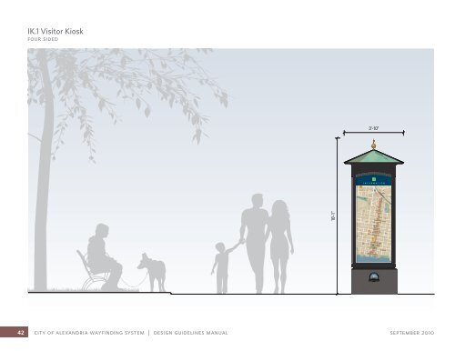
IK.1 Visitor Kiosk<br />
four sided<br />
INFORMATION<br />
42 city <strong>of</strong> alexandria wayfinding system | design guidelines manual september 2010<br />
10'-1"<br />
3'-10"
5'-0" 8"<br />
2'-3"<br />
Typical View<br />
(same on all sides except for content)<br />
3D Study<br />
Illumination: Downward Illumination: Back lit<br />
objectives<br />
IK.1 Visitor Kiosk<br />
four sided<br />
• Provide orientation, events and interpretive content<br />
at key pedestrian nodes, transit centers, and bike trail<br />
entry points<br />
• Content panels to be modular, adaptable to wall<br />
mounting, and easily updated/changed out by city staff<br />
• Reinforce District Identity, which appears on “headers”<br />
• Create uniform, recognizable structure, city-wide,<br />
reinforcing <strong>City</strong> <strong>of</strong> <strong>Alexandria</strong> identity<br />
rationale<br />
Large scale kiosk provides for four individual panels <strong>of</strong><br />
information in an elegant, civic structure. Panels are<br />
easily and inexpensively updated.<br />
location<br />
Located at key plaza spaces where the kiosk may be<br />
approached from all sides.<br />
content<br />
Sides A & C: Visitor maps (see page 32)<br />
Sides B & D: Historic interpretive panel, seasonal<br />
events, or public art.<br />
illumination<br />
Option 1: Lights concealed in the ro<strong>of</strong> structure wash<br />
sign faces, as well as the ground, in a pool <strong>of</strong> welcoming<br />
light (recommended at Market Square).<br />
Option 2: Translucent plastic sign faces are internally<br />
illuminated, for maximum glow at night (recommended<br />
at Metro Stations).<br />
material<br />
Painted metal structure with stone base. Digitally<br />
printed graphics.<br />
september 2010 section 2: sign family 43
IK.2 Visitor Kiosk<br />
two sided<br />
44 city <strong>of</strong> alexandria wayfinding system | design guidelines manual september 2010<br />
8'-0"<br />
3'-7"<br />
INFORMATION
5'-0"<br />
2'-10"<br />
2'-3"<br />
INFORMATION<br />
Front View<br />
Back View<br />
(may be blank if installed in front <strong>of</strong> a wall)<br />
rationale<br />
IK.2 Visitor Kiosk<br />
two sided<br />
Smaller kiosk structure allows for two back-to-back<br />
panels <strong>of</strong> information. Panel artwork matches the size<br />
<strong>of</strong> the IK.1 panels in order to minimize artwork development<br />
expenses.<br />
location<br />
Located at secondary spaces where a major kiosk is<br />
deemed unnecessary or will not fit. May also be used<br />
as a single sided, freestanding alternative to IK.3. Typically<br />
located along bike trails, at transit centers, or at<br />
parking garages.<br />
content<br />
Side A: Map (see page 32)<br />
Side B (when used): Historic interpretive panel, seasonal<br />
events, or public art.<br />
material<br />
Painted metal with digitally printed graphics.<br />
september 2010 section 2: sign family 45
IK.3 Visitor Kiosk<br />
wall mounted<br />
INFORMATION<br />
46 city <strong>of</strong> alexandria wayfinding system | design guidelines manual september 2010<br />
1'-6" 6'-6"<br />
3'-0"
6'-6"<br />
5'-0"<br />
3'-0"<br />
2'-3"<br />
INFORMATION<br />
Front View<br />
rationale<br />
IK.3 Visitor Kiosk<br />
wall mounted<br />
An alternate kiosk structure, sized to match IK.2 but<br />
mounting directly to an existing wall. Panels are fully<br />
interchangeable with IK.2.<br />
location<br />
Typically located at parking garages.<br />
content<br />
Map (see page 32)<br />
materials<br />
Same as IK.2<br />
september 2010 section 2: sign family 47
PD.1 Pedestrian Directional<br />
pointer<br />
Carlyle<br />
5 min walk to Federal Courthouse<br />
5 min walk to USPTO<br />
Old Town<br />
20 min walk to Waterfront<br />
48 city <strong>of</strong> alexandria wayfinding system | design guidelines manual september 2010<br />
12'-0"<br />
8'-0" minimun<br />
3'-7"
Carlyle<br />
5 min walk to Federal Courthouse<br />
5 min walk to USPTO<br />
Typical View<br />
(varies depending on direction blades point)<br />
Old Town<br />
20 min walk to Waterfront<br />
3D Study<br />
objectives<br />
PD.1 Pedestrian Directional<br />
pointer<br />
• Quickly orient and direct users when they arrive at<br />
confusing areas (<strong>of</strong>f the city grid)<br />
• Provide international icons that broadly highlight area<br />
amenities<br />
rationale<br />
Double sided pointer sign provides a quick, “heads-up,”<br />
cant-miss orientation to visitors as they arrive on site.<br />
location<br />
Located at plaza spaces where pedestrians may begin<br />
their exploration on foot (transit stops, water taxi,<br />
motorcoach drop-<strong>of</strong>fs, etc.)<br />
content<br />
Primary directional destination, with supplemental<br />
walking time information and amenity icons.<br />
material<br />
Painted metal with applied vinyl graphics.<br />
september 2010 section 2: sign family 49
PD.2 Pedestrian Directional<br />
mini kiosk<br />
4'-0" 3'-3 1/4"<br />
1'-1"<br />
WALKING MAP LEGEND<br />
Information<br />
King Street Trolley Stop<br />
5-minute walk (¼ Mile)<br />
Shopping & Dining<br />
MetroRail Station<br />
Museum<br />
Park Park<br />
Public Parking<br />
Lodging<br />
Attraction Attraction<br />
Taxi Stand<br />
Bike Repairs<br />
Civic Civic Destination<br />
Bike Route<br />
50 city <strong>of</strong> alexandria wayfinding system | design guidelines manual september 2010
3'-3 1/4"<br />
1'-1"<br />
WALKING MAP LEGEND<br />
Information<br />
King Street Trolley Stop<br />
5-minute walk (¼ Mile)<br />
Shopping & Dining<br />
MetroRail Station<br />
Museum<br />
Park Park<br />
Public Parking<br />
Lodging<br />
Attraction Attraction<br />
Taxi Stand<br />
Bike Repairs<br />
Civic Civic Destination<br />
Bike Route<br />
Front View<br />
(facing up street)<br />
Side<br />
(facing street)<br />
WALKING MAP LEGEND<br />
Information<br />
King Street Trolley Stop<br />
5-minute walk (¼ Mile)<br />
Shopping & Dining<br />
MetroRail Station<br />
Museum<br />
Park Park<br />
Public Parking<br />
Lodging<br />
Attraction Attraction<br />
Taxi Stand<br />
Bike Repairs<br />
Civic Civic Destination<br />
Bike Route<br />
Back View<br />
(facing up street)<br />
F R A N K L IN S T<br />
H O O F F S R U N D R<br />
S A V O Y S T<br />
S PA T R IC K S T<br />
J O H N C A R LY L E S T<br />
G IB B O N S T<br />
H A M ILT O N L A<br />
S PA T R IC K S T<br />
S P IT T S T<br />
S F A IR F A X S T<br />
S L E E S T<br />
E IS E N H O W E R A V<br />
W O L F E S T<br />
E M E R S O N AV<br />
H O L L A N D L A<br />
W IL K E S S T<br />
S U N IO N S T<br />
R O U N D H O U S E L A<br />
B A L L E N G E R AV<br />
J A M IE S O N A V<br />
S A L F R E D S T<br />
N P IT T S T<br />
S R O Y A L S T<br />
P R IN C E S T<br />
D U K E S T<br />
S W E S T S T<br />
K IN G S T<br />
R E IN E K E R S L A<br />
N U N IO N S T<br />
N F AY E T T E S T<br />
C A M E R O N S T<br />
Q U E E N S T<br />
N R O Y A L S T<br />
P R IN C E S S S T<br />
B O Y L E S T<br />
N W E S T S T<br />
D E V E R S C T<br />
N P AT R IC K S T<br />
N A L F R E D S T<br />
N C O L U M B U S S T<br />
S C O L U M B U S S T<br />
S W A S H IN G T O N S T<br />
S S A IN T A S A P H S T<br />
N S A IN T A S A P H S T<br />
J E F F E R S O N C T<br />
W IL K E S S T<br />
W IL K E S S T<br />
S H E N R Y S T<br />
R O U N D H O U S E L A<br />
S T R A N D S T<br />
D U K E S T<br />
J A M IE S O N A V<br />
IR V IN G C T<br />
G E O R G E 'S L A<br />
S PA Y N E S T<br />
S F A Y E T T E S T<br />
S F A Y E T T E S T<br />
Nannie J .<br />
Lee<br />
Center<br />
Potomac<br />
View /<br />
Windmill<br />
Hill<br />
Shipyard<br />
Park<br />
African<br />
American<br />
Heritage<br />
Park<br />
M A K E L E Y A L<br />
W A L E S A L<br />
C H E R R Y A L<br />
S W IF T S A L<br />
C O M M E R C E S T<br />
D IA G O N A L R D<br />
D A IN G E R F IE L D R D<br />
F AY E T T E A L<br />
S P E Y T O N S T<br />
S PA Y N E S T<br />
S F A Y E T T E S T<br />
E M E R S O N 'S A L<br />
R A M S AY A L<br />
D O W N H A M W Y<br />
C O M M E R C E S T<br />
D E C H A N TA L S T<br />
N W A S H IN G T O N S T<br />
R O S S A L<br />
C A M E R O N S T<br />
C A M E R O N M E<br />
T H O M P S O N S A L<br />
T H O M P S O N S A L<br />
P IT T M E<br />
R U S S E L L R D<br />
Sunset<br />
Mini Park<br />
King Street<br />
Ho<strong>of</strong>f's<br />
Run Park<br />
&<br />
Greenway<br />
King<br />
Street<br />
Gardens<br />
H A R VA R D S T<br />
N P E Y T O N S T<br />
Washington<br />
Way<br />
Armory<br />
Tot Lot<br />
Market<br />
Square<br />
Roberdeau<br />
Point<br />
Old<br />
Park<br />
Lumley<br />
Dominion<br />
Waterfront Boat Club<br />
Park<br />
C A M E R O N S T<br />
M U IR S C T<br />
S U N S E T D R<br />
C O M M O N W E A LT H AV<br />
C E D A R S T<br />
B U C H A N A N S T<br />
Fayette &<br />
Queen<br />
Park<br />
N H E N R Y S T<br />
< N ull><br />
N F A IR F A X S T<br />
T O B A C C O Q Y<br />
Q U A Y S T<br />
B R O C K E T T S A L<br />
Y E A T O N A L<br />
N L E E S T<br />
C R O M L E Y A L<br />
D E L A N E Y C T<br />
E U IL L E S T<br />
W R O S E M O N T AV<br />
M O U N T V E R N O N A V<br />
H O P K IN S C T<br />
E R O S E M O N T AV<br />
E A R L S T<br />
N P AY N E S T<br />
C O O K S T<br />
O R O N O C O S T<br />
S U T E R S T<br />
W L IN D E N S T<br />
Metro<br />
Linear<br />
Park<br />
N P E Y T O N S T<br />
Torpedo<br />
Factory &<br />
<strong>City</strong><br />
Founders<br />
Marina<br />
Park<br />
West's<br />
Point<br />
E L IN D E N S T<br />
P E N D L E T O N S T<br />
W M A P L E S T<br />
L IT T L E S T<br />
C O L E C R O F T C T<br />
T IV O L I P G<br />
E M A P L E S T<br />
M O U N T V E R N O N A V<br />
Pendleton<br />
Park<br />
Interior<br />
Park<br />
Rowing<br />
Facility<br />
Wythe<br />
Street<br />
Plaza<br />
Oronoco<br />
Bay Park<br />
Side<br />
(facing sidewalk)<br />
W Y T H E S T<br />
3D Study<br />
objectives<br />
PD.2 Pedestrian Directional<br />
mini kiosk<br />
• Encourage a pedestrian/walking environment by<br />
providing optimally-placed and reassuring orientation<br />
along key walking corridors<br />
• Extend the wayfinding system from parking areas,<br />
transit nodes, trolley stops and bike paths<br />
• Provide detailed maps that highlight visitor amenities,<br />
attractions, public transit, and retail zones<br />
• Include areas for historical/cultural information<br />
• In Old Town, expand the pedestrian corridor beyond<br />
King Street onto cross streets and parallel streets; highlight<br />
retail/restaurant areas both on and <strong>of</strong>f King Street<br />
rationale<br />
Four-sided information cabinet mounts to existing<br />
poles (Gadsby lights in Old Town), providing convenient<br />
wayfinding reinforcement periodically in areas <strong>of</strong><br />
pedestrian concentration.<br />
location<br />
Located at key pedestrian “decision points” and periodically<br />
along pedestrian corridors. In Old Town, mini<br />
kiosks will be located at designated intersections along<br />
King Street, on opposite diagonal corners, to emphasize<br />
side street destinations/services. Several will also<br />
be located along Cameron and at waterfront parks.<br />
content<br />
Sides facing up & down the sidewalk: Maps and directional<br />
information<br />
Side facing away from street: Historic interpretive<br />
panel, seasonal events, or public art.<br />
Side facing street: Abstract image (so as not to encourage<br />
standing in the street to view)<br />
Trolley stop logo may be added to sign face at appropriate<br />
locations.<br />
september 2010 section 2: sign family 51
PD.3 Pedestrian Directional<br />
a-frame<br />
Shopping<br />
Stabler−<br />
Leadbeater<br />
Apothecary<br />
Museum<br />
Old Presbyterian<br />
Meeting House<br />
<strong>City</strong> Hall<br />
King St<br />
15 BLOCKS<br />
Waterfront<br />
3 BLOCKS<br />
3'-6"<br />
2'-0"<br />
52 city <strong>of</strong> alexandria wayfinding system | design guidelines manual september 2010
3'-6"<br />
2'-0"<br />
21” x 28” space may be<br />
subdivided as necessary<br />
to accommodate any<br />
number <strong>of</strong> businesses<br />
Front View<br />
rationale<br />
PD.3 Pedestrian Directional<br />
a-frame<br />
A-frame signs coordinate with the design character <strong>of</strong><br />
the wayfinding program, and allow increased visibility<br />
for shopping and dining on side streets. Eligible businesses<br />
may partner together to apply for a group Aframe<br />
sign permit. Business owners are responsible for<br />
coordinating with other eligible businesses, fabricating<br />
and paying for the signs, and complying with city ordinance<br />
and guidelines administered by the Department<br />
<strong>of</strong> Planning and Zoning.<br />
locations<br />
Placed at street corners to direct to businesses on that<br />
street in approved location complying with ADA and<br />
pedestrian access.<br />
content and design<br />
Typeface, flourishes and arrows are standard to the<br />
wayfinding system and must be matched. “Shopping<br />
and Dining” message may change depending on which<br />
services are available on a given street. The live area in<br />
the center <strong>of</strong> the sign may be subdivided into strips to<br />
accommodate however many businesses will appear.<br />
material<br />
Solid painted black metal frame. Painted black metal<br />
sign panels <strong>of</strong> minimum thickness and stability per<br />
program requirements sufficient to keep the sign face<br />
rigid in the frame and to prevent tipping.<br />
september 2010 section 2: sign family 53
BP.1 Shared-Use Path Directional<br />
1'-6" minimum<br />
54 city <strong>of</strong> alexandria wayfinding system | design guidelines manual september 2010<br />
6'-0"<br />
1'-4"<br />
MOUNT<br />
VERNON<br />
TRAIL
3'-9"<br />
2'-11 1/4" 6 3/4"<br />
1'-0"<br />
Mt. Vernon<br />
Trail to<br />
Points North<br />
Mt. Vernon<br />
Trail<br />
Alternate<br />
on Royal<br />
Street<br />
MOUNT<br />
VERNON<br />
TRAIL<br />
Front Views, showing alternate graphics layouts depending on content<br />
objectives<br />
BP.1 Shared-Use Path Directional<br />
• Clearly identify key bike trails as they enter <strong>Alexandria</strong><br />
• Consolidate national trail symbols into cohesive graphic<br />
expression<br />
• Encourage exploration <strong>of</strong> <strong>Alexandria</strong> retail/dining by<br />
path users<br />
• Point out bike-related amenities and services<br />
• Coordinate trail signage and “brand” the paths, thereby<br />
presenting <strong>Alexandria</strong> as bike-friendly and encouraging<br />
visitation<br />
rationale<br />
Double sided directional sign is scaled for visibility by<br />
cyclists and other trail users. The header panel unifies<br />
trails into a single citywide system.<br />
locations<br />
Located along <strong>of</strong>f-street multi-use trails throughout the<br />
city, at trailheads, key trail intersections, and transitions<br />
to on-street trails.<br />
content<br />
Multiple type grids allow for flexibility in information<br />
content. Typical content may:<br />
• Provide direction at confusing turns or breaks in the trail<br />
• Direct to amenities, attracting through-travelers to<br />
local services<br />
• Identify named trails, particularly those with multiple<br />
designations<br />
material<br />
Painted metal, applied vinyl and digitally printed<br />
graphics.<br />
september 2010 section 2: sign family 55
IN Interpretive<br />
F R A N K L IN S T<br />
H O O F F S R U N D R<br />
S A V O Y S T<br />
S PA Y N E S T<br />
S F A IR F A X S T<br />
J O H N C A R LY L E S T<br />
G IB B O N S T<br />
H A M ILT O N L A<br />
S PA T R IC K S T<br />
S L E E S T<br />
S W A S H IN G T O N S T<br />
S P IT T S T<br />
W O L F E S T<br />
H O L L A N D L A<br />
W IL K E S S T<br />
S S A IN T A S A P H S T<br />
S U N IO N S T<br />
J A M IE S O N A V<br />
S A L F R E D S T<br />
P R IN C E S T<br />
D U K E S T<br />
S W E S T S T<br />
S F A Y E T T E S T<br />
S F A Y E T T E S T<br />
Nannie J .<br />
Lee<br />
Center<br />
S PA T R IC K S T<br />
E IS E N H O W E R A V<br />
J E F F E R S O N C T<br />
Potomac<br />
View /<br />
Windmill<br />
Hill<br />
W IL K E S S T<br />
W IL K E S S T<br />
E M E R S O N AV<br />
S H E N R Y S T<br />
R O U N D H O U S E L A<br />
B A L L E N G E R AV<br />
S T R A N D S T<br />
G E O R G E 'S L A<br />
African<br />
American<br />
Heritage<br />
Park<br />
R O U N D H O U S E L A<br />
D U K E S T<br />
J A M IE S O N A V<br />
IR V IN G C T<br />
M A K E L E Y A L<br />
S R O Y A L S T<br />
C O M M E R C E S T<br />
K IN G S T<br />
R E IN E K E R S L A<br />
N P IT T S T<br />
D IA G O N A L R D<br />
D A IN G E R F IE L D R D<br />
S P E Y T O N S T<br />
N U N IO N S T<br />
D E C H A N TA L S T<br />
N F AY E T T E S T<br />
C A M E R O N S T<br />
S U N S E T D R<br />
Q U E E N S T<br />
N R O Y A L S T<br />
N F A IR F A X S T<br />
N W E S T S T<br />
N H E N R Y S T<br />
S C O L U M B U S S T N C O L U M B U S S T<br />
W A L E S A L<br />
S PA Y N E S T<br />
S F A Y E T T E S T<br />
C H E R R Y A L<br />
S W IF T S A L<br />
F AY E T T E A L<br />
E M E R S O N 'S A L<br />
R A M S AY A L<br />
D O W N H A M W Y<br />
C O M M E R C E S T<br />
N W A S H IN G T O N S T<br />
Armory<br />
Tot Lot<br />
Market<br />
Square<br />
R O S S A L<br />
C A M E R O N S T<br />
C A M E R O N M E<br />
T H O M P S O N S A L<br />
T H O M P S O N S A L<br />
P IT T M E<br />
R U S S E L L R D<br />
H A R VA R D S T<br />
N P E Y T O N S T<br />
Roberdeau<br />
Point<br />
Old Torpedo<br />
Park<br />
Factory &<br />
Lumley<br />
Dominion<br />
Waterfront Boat Club <strong>City</strong><br />
Park<br />
Marina<br />
Shipyard<br />
Park<br />
Sunset<br />
Mini Park<br />
King Street<br />
Ho<strong>of</strong>f's<br />
Run Park<br />
&<br />
Greenway<br />
King<br />
Street<br />
Gardens<br />
Washington<br />
Way<br />
C A M E R O N S T<br />
C O M M O N W E A LT H AV<br />
< N ull><br />
C E D A R S T<br />
B U C H A N A N S T<br />
N A L F R E D S T<br />
N L E E S T<br />
P R IN C E S S S T<br />
N P AY N E S T<br />
D E V E R S C T<br />
N P AT R IC K S T<br />
M U IR S C T<br />
Q U A Y S T<br />
B R O C K E T T S A L<br />
Y E A T O N A L<br />
C R O M L E Y A L<br />
D E L A N E Y C T<br />
N S A IN T A S A P H S T<br />
Founders<br />
Park<br />
E U IL L E S T<br />
M O U N T V E R N O N A V<br />
Fayette &<br />
Queen<br />
Park<br />
B O Y L E S T<br />
W R O S E M O N T AV<br />
H O P K IN S C T<br />
T O B A C C O Q Y<br />
E R O S E M O N T AV<br />
C O O K S T<br />
E A R L S T<br />
O R O N O C O S T<br />
S U T E R S T<br />
W L IN D E N S T<br />
N P E Y T O N S T<br />
E L IN D E N S T<br />
P E N D L E T O N S T<br />
W M A P L E S T<br />
Metro<br />
Linear<br />
Park<br />
West's<br />
Point<br />
L IT T L E S T<br />
C O L E C R O F T C T<br />
T IV O L I P G<br />
E M A P L E S T<br />
M O U N T V E R N O N A V<br />
Pendleton<br />
Park<br />
Interior<br />
Park<br />
W Y T H E S T<br />
Wythe<br />
Street<br />
Plaza<br />
Oronoco<br />
Bay Park<br />
Rowing<br />
Facility<br />
Standard size NPS-styled wayside tablets Panels for display in PD.2 Mini Kiosk signs Panels embedded in ground plane/sidewalks (sizes may vary) Panels for display in IK Visitor Kiosks<br />
56 city <strong>of</strong> alexandria wayfinding system | design guidelines manual september 2010
Design palette for standard size NPS-styled wayside tablet (detail)<br />
objectives<br />
IN Interpretive<br />
• Provide a <strong>City</strong>wide standard system for the presentation<br />
<strong>of</strong> detailed and engaging historical and cultural<br />
information<br />
• Relate the design palette to the overall <strong>City</strong> Wayfinding<br />
sign system, presenting an attractive, pr<strong>of</strong>essional, and<br />
coordinated city image<br />
• Create a range <strong>of</strong> sign types that allow the sensitive<br />
placement and appropriate display <strong>of</strong> information in a<br />
wide range <strong>of</strong> contexts<br />
rationale<br />
The design palette for Interpretive signs represents a<br />
freshening <strong>of</strong> standards already in place to allow for<br />
phase-in over time. Templates have been developed<br />
for multiple applications including:<br />
• standard-sized National Park Service-style tablets<br />
• panels for display in PD.2 Mini Kiosk signs (see p 51)<br />
• panels for display in IK Visitor Kiosks (see p 43-47)<br />
• embedded in the ground plane/sidewalks (sizes may<br />
vary)<br />
locations<br />
Multiple configurations allow for use at a wide variety<br />
<strong>of</strong> sites as will be determined by the Office <strong>of</strong> Historic<br />
<strong>Alexandria</strong>.<br />
content<br />
Specific content will be developed by the Office <strong>of</strong> Historic<br />
<strong>Alexandria</strong>. The <strong>Alexandria</strong> Heritage Trail logo may<br />
appear to designate individual sites which are part <strong>of</strong> a<br />
larger network for which guide materials are available.<br />
material<br />
Panels: digitally printed graphics (DHPL, fiberglass or<br />
porcelain enamel).<br />
Ground plane sign: cast or etched metal.<br />
september 2010 section 2: sign family 57