- Page 1 and 2:
INTERNATIONAL ASSOCIATION FOR DANUB
- Page 3 and 4:
The conference was organized under
- Page 5 and 6:
Content Keynote lectures Macrophyte
- Page 7 and 8:
Content Bioassessment of a heavily
- Page 9:
Keynote lecture
- Page 12 and 13:
39th IAD Conference, August 2012, S
- Page 14 and 15:
39th IAD Conference, August 2012, S
- Page 16 and 17:
39th IAD Conference, August 2012, S
- Page 18 and 19:
39th IAD Conference, August 2012, S
- Page 20 and 21:
39th IAD Conference, August 2012, S
- Page 22 and 23:
39th IAD Conference, August 2012, S
- Page 24 and 25:
39th IAD Conference, August 2012, S
- Page 26 and 27: 39th IAD Conference, August 2012, S
- Page 28 and 29: 39th IAD Conference, August 2012, S
- Page 30 and 31: 39th IAD Conference, August 2012, S
- Page 33 and 34: Topic 1: Ecological processes in ri
- Page 35 and 36: 39th IAD Conference, August 2012, S
- Page 37: 39th IAD Conference, August 2012, S
- Page 40 and 41: 39th IAD Conference, August 2012, S
- Page 42 and 43: 39th IAD Conference, August 2012, S
- Page 44 and 45: 39th IAD Conference, August 2012, S
- Page 47 and 48: Topic 1: Ecological processes in ri
- Page 49 and 50: 39th IAD Conference, August 2012, S
- Page 51 and 52: 39th IAD Conference, August 2012, S
- Page 53 and 54: Topic 1: Ecological processes in ri
- Page 55 and 56: 39th IAD Conference, August 2012, S
- Page 57 and 58: 39th IAD Conference, August 2012, S
- Page 59: 39th IAD Conference, August 2012, S
- Page 63 and 64: Topic 2: Longitudinal, vertical and
- Page 65 and 66: Secchi depth [m] 0.0 0.2 0.4 0.6 0.
- Page 67 and 68: Discussion 39th IAD Conference, Aug
- Page 69 and 70: 39th IAD Conference, August 2012, S
- Page 71 and 72: Topic 2: Longitudinal, vertical and
- Page 73 and 74: 39th IAD Conference, August 2012, S
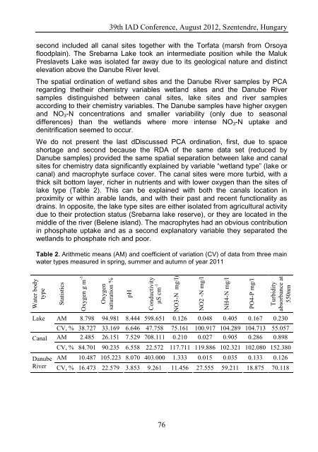
- Page 75: 39th IAD Conference, August 2012, S
- Page 79: 39th IAD Conference, August 2012, S
- Page 82 and 83: 39th IAD Conference, August 2012, S
- Page 84 and 85: 39th IAD Conference, August 2012, S
- Page 86 and 87: 39th IAD Conference, August 2012, S
- Page 88 and 89: Acknowledgments 39th IAD Conference
- Page 91 and 92: Topic 3: Changes in biodiversity Hi
- Page 93 and 94: 39th IAD Conference, August 2012, S
- Page 95 and 96: 39th IAD Conference, August 2012, S
- Page 97: References 39th IAD Conference, Aug
- Page 101 and 102: Topic 6: Environment and infrastruc
- Page 103 and 104: 39th IAD Conference, August 2012, S
- Page 105 and 106: 39th IAD Conference, August 2012, S
- Page 107: 39th IAD Conference, August 2012, S
- Page 111 and 112: Topic 8: Technical aspects and the
- Page 113 and 114: Mapping of the virtual scenery 39th
- Page 115 and 116: Outlook 39th IAD Conference, August
- Page 117 and 118: Topic 8: Technical aspects and the
- Page 119 and 120: 39th IAD Conference, August 2012, S
- Page 121 and 122: 39th IAD Conference, August 2012, S
- Page 123: Topic 9 Restoration ecology, landsc
- Page 126 and 127:
39th IAD Conference, August 2012, S
- Page 128 and 129:
Results for the Danube 39th IAD Con
- Page 130 and 131:
39th IAD Conference, August 2012, S
- Page 133 and 134:
Topic 1: Ecological processes in ri
- Page 135 and 136:
39th IAD Conference, August 2012, S
- Page 137 and 138:
39th IAD Conference, August 2012, S
- Page 139:
References 39th IAD Conference, Aug
- Page 142 and 143:
39th IAD Conference, August 2012, S
- Page 144 and 145:
39th IAD Conference, August 2012, S
- Page 146 and 147:
39th IAD Conference, August 2012, S
- Page 148 and 149:
References 39th IAD Conference, Aug
- Page 150 and 151:
39th IAD Conference, August 2012, S
- Page 152 and 153:
a) c) 39th IAD Conference, August 2
- Page 154 and 155:
39th IAD Conference, August 2012, S
- Page 157 and 158:
Topic 1: Ecological processes in ri
- Page 159 and 160:
39th IAD Conference, August 2012, S
- Page 161 and 162:
39th IAD Conference, August 2012, S
- Page 163 and 164:
39th IAD Conference, August 2012, S
- Page 165:
Topic 2 Longitudinal, vertical and
- Page 168 and 169:
39th IAD Conference, August 2012, S
- Page 170 and 171:
39th IAD Conference, August 2012, S
- Page 173 and 174:
Topic 2: Longitudinal, vertical and
- Page 175 and 176:
39th IAD Conference, August 2012, S
- Page 177 and 178:
Suggestions for proper operation 39
- Page 179 and 180:
Topic 2: Longitudinal, vertical and
- Page 181 and 182:
39th IAD Conference, August 2012, S
- Page 183 and 184:
Conclusions 39th IAD Conference, Au
- Page 185:
39th IAD Conference, August 2012, S
- Page 189 and 190:
Topic 3: Changes in biodiversity Di
- Page 191 and 192:
39th IAD Conference, August 2012, S
- Page 193 and 194:
39th IAD Conference, August 2012, S
- Page 195 and 196:
Topic 3: Changes in biodiversity Zo
- Page 197 and 198:
39th IAD Conference, August 2012, S
- Page 199 and 200:
39th IAD Conference, August 2012, S
- Page 201:
39th IAD Conference, August 2012, S
- Page 204 and 205:
39th IAD Conference, August 2012, S
- Page 206 and 207:
39th IAD Conference, August 2012, S
- Page 208 and 209:
39th IAD Conference, August 2012, S
- Page 210 and 211:
39th IAD Conference, August 2012, S
- Page 212 and 213:
39th IAD Conference, August 2012, S
- Page 214 and 215:
39th IAD Conference, August 2012, S
- Page 217 and 218:
Topic 3: Changes in biodiversity Di
- Page 219 and 220:
39th IAD Conference, August 2012, S
- Page 221 and 222:
39th IAD Conference, August 2012, S
- Page 223 and 224:
39th IAD Conference, August 2012, S
- Page 225:
39th IAD Conference, August 2012, S
- Page 229 and 230:
Topic 6: Environment and infrastruc
- Page 231 and 232:
Results and Discussion 39th IAD Con
- Page 233 and 234:
39th IAD Conference, August 2012, S
- Page 235:
39th IAD Conference, August 2012, S
- Page 238 and 239:
39th IAD Conference, August 2012, S
- Page 240 and 241:
39th IAD Conference, August 2012, S
- Page 242 and 243:
39th IAD Conference, August 2012, S
- Page 245 and 246:
Topic 7: Environment and the implem
- Page 247 and 248:
39th IAD Conference, August 2012, S
- Page 249 and 250:
39th IAD Conference, August 2012, S
- Page 251 and 252:
39th IAD Conference, August 2012, S
- Page 253:
Topic 8 Technical aspects and the i
- Page 256 and 257:
39th IAD Conference, August 2012, S
- Page 258 and 259:
39th IAD Conference, August 2012, S
- Page 260 and 261:
39th IAD Conference, August 2012, S
- Page 262 and 263:
Materials and methods 39th IAD Conf
- Page 264 and 265:
Simpson's index 3,5 3 2,5 2 1,5 1 0
- Page 266 and 267:
39th IAD Conference, August 2012, S
- Page 269 and 270:
Topic 8: Technical aspects and the
- Page 271 and 272:
39th IAD Conference, August 2012, S
- Page 273 and 274:
39th IAD Conference, August 2012, S
- Page 275:
References 39th IAD Conference, Aug
- Page 279 and 280:
Topic 9: Restoration ecology, lands
- Page 281 and 282:
39th IAD Conference, August 2012, S
- Page 283:
39th IAD Conference, August 2012, S
- Page 286:
286