- Page 1 and 2: European Organization for Experimen
- Page 3 and 4: EUROPEAN ORGANIZATION for EXPERIMEN
- Page 5 and 6: Mr. F. PAPI MONTANEL Spain Institut
- Page 7 and 8: Table of contents D. Holland, B. Gu
- Page 9 and 10: Oeepe - Project on Topographic Mapp
- Page 11 and 12: Figure 5 Local binary difference be
- Page 13 and 14: Summary The aim of this project was
- Page 15 and 16: 1.2 Work packages OEEPE members exp
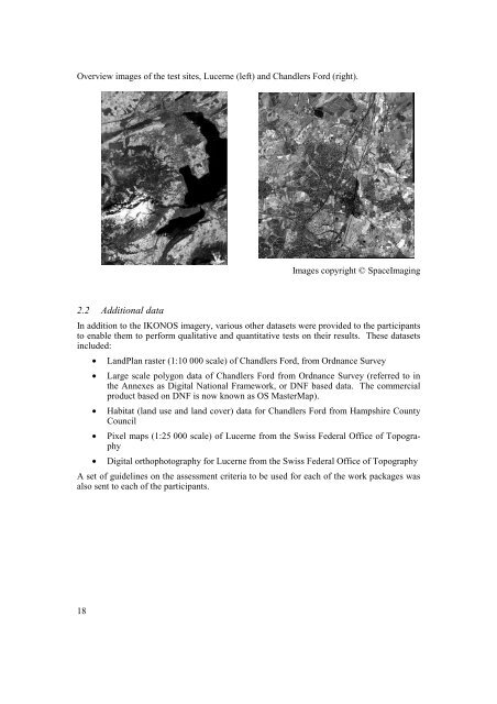
- Page 17: To enable the work to commence, it
- Page 21 and 22: Major point features such as railwa
- Page 23 and 24: This aim of the study was to compar
- Page 25 and 26: 3.4.4 A summary of the Work Package
- Page 27 and 28: 4.4 Challenges to existing products
- Page 29: 6 Recommendations Mapping organizat
- Page 32 and 33: 1 Introduction 1.1 Background The a
- Page 34 and 35: Figure 1: Area 1. Rural / urban sub
- Page 36 and 37: Table 1: Summary of the findings of
- Page 38 and 39: 2.4.2 Roads. All major roads could
- Page 40 and 41: Derek Ireson at Z/I Imaging. Experi
- Page 42 and 43: for comparison was digital ortho-im
- Page 44 and 45: features. The amount of distortion
- Page 46 and 47: Table 5 Flowline costs Process Aeri
- Page 48 and 49: 1. Z/I Imaging workstations for aer
- Page 50 and 51: 5.5 Examples of the use of IKONOS i
- Page 52 and 53: 1:50,000 - for full specification 1
- Page 54 and 55: 1 Aim and objectives The major aim
- Page 56 and 57: 3.2 Communication Figure 2 shows tw
- Page 58 and 59: 3.4 Drainage Figure 4 shows two sub
- Page 61 and 62: OEEPE - Project Topographic Mapping
- Page 63 and 64: spectral range 0.45 - 0.90 b/w pan
- Page 65 and 66: Figure 1: original geometric relati
- Page 67 and 68: 4 Geometry of CARTERRA Geo The geom
- Page 69 and 70:
Figure 8: differences after correct
- Page 71 and 72:
Oeepe - Project on Topographic Mapp
- Page 73 and 74:
example, IKONOS MS imagery for one
- Page 75 and 76:
Binary difference For a moving (2w+
- Page 77 and 78:
Figure 1 shows how several features
- Page 79 and 80:
Figure 3. (a) k-means classificatio
- Page 81 and 82:
4.3.2 Type Figure 5a shows the loca
- Page 83 and 84:
Figures 7a and b show the local (th
- Page 85 and 86:
For the agricultural area, the reas
- Page 87 and 88:
5 Discussion 5.1 Geometric registra
- Page 89 and 90:
6 Conclusion The objective of this
- Page 91 and 92:
OEEPE - Project Topographic Mapping
- Page 93 and 94:
esult of the level of spatial gener
- Page 95 and 96:
The 44 classes were specified such
- Page 97 and 98:
when there is an abundance of small
- Page 99 and 100:
Table 1 (b). Relation of CORINE cla
- Page 101 and 102:
The four classes were chosen to rep
- Page 103 and 104:
mation available to the classifier.
- Page 105 and 106:
Oeepe - Project on Topographic Mapp
- Page 107 and 108:
Outline Background / Motivation Dat
- Page 109 and 110:
Available Satellite Data • IKONOS
- Page 111 and 112:
Available Map Data Scanned OS Landp
- Page 113 and 114:
Spectral Properties Spectral Bands
- Page 115 and 116:
CORINE 44 Landuse units 5 Main cato
- Page 117 and 118:
Variables Variables Options CORINE
- Page 119 and 120:
ERDAS • MS-Channels RGB,NIR • N
- Page 121 and 122:
Expert Classifier • Texture from
- Page 123 and 124:
Prelimnary Accuracy Assessment Inst
- Page 125 and 126:
Influence of image object sizes Sma
- Page 127 and 128:
Level 4 Form, texture and spatial r
- Page 129 and 130:
1,00 0,90 0,80 0,70 0,60 0,50 0,40
- Page 131 and 132:
Problems due to spectral resolution
- Page 133 and 134:
Conclusions 1. Interpretation key s
- Page 135 and 136:
OEEPE - Project Topographic Mapping
- Page 137 and 138:
Figure 1: Signature Mean Plot of th
- Page 139 and 140:
4 Conclusion The multispectral Ikon
- Page 141 and 142:
Image 1b : Unsupervised Classified
- Page 143 and 144:
Image 1d : Supervised Classified Im
- Page 145 and 146:
Image 1f : Landmap (Ordnance Survey
- Page 147 and 148:
Image 2b : Unsupervised Classified
- Page 149 and 150:
Image 2d : Supervised Classified Im
- Page 151:
Image 2f : Landmap (Ordnance Survey
- Page 154 and 155:
Harrison, A.R.; D’souza, G; and S
- Page 157 and 158:
LIST OF THE OEEPE PUBLICATIONS Stat
- Page 159 and 160:
20 Eichhorn, G.: Summary of Replies