Watershed Presentation for COS (Revised) - Department of ...
Watershed Presentation for COS (Revised) - Department of ...
Watershed Presentation for COS (Revised) - Department of ...

You also want an ePaper? Increase the reach of your titles
YUMPU automatically turns print PDFs into web optimized ePapers that Google loves.
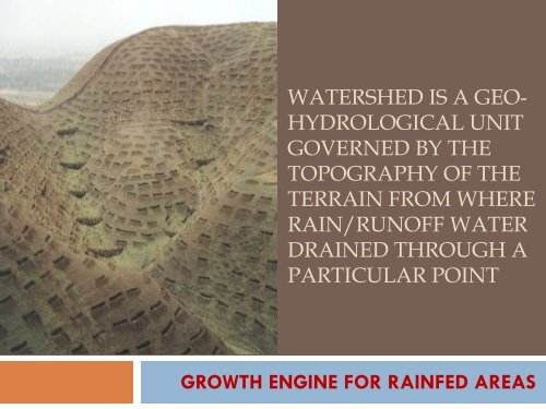
WATERSHED IS A GEO-<br />
HYDROLOGICAL UNIT<br />
GOVERNED BY THE<br />
TOPOGRAPHY OF THE<br />
TERRAIN FROM WHERE<br />
RAIN/RUNOFF WATER<br />
DRAINED THROUGH A<br />
PARTICULAR POINT<br />
GROWTH ENGINE FOR RAINFED AREAS
<strong>Watershed</strong> as Planning Tool<br />
<strong>Watershed</strong> constitutes natural spatial frame <strong>of</strong><br />
hydrologic units <strong>for</strong> harnessing and utilizing water, soil<br />
and <strong>for</strong>est resources in a sustainable manner within its<br />
natural eco-system.<br />
Delineation and codification <strong>of</strong> watershed <strong>of</strong> a<br />
country allows recognizing each hydrologic unit with<br />
unique ‘National Code’ that provides a vital plat<strong>for</strong>m<br />
to synergize all developmental programmes related<br />
to natural resources management, rural livelihoods<br />
etc., avoiding duplication <strong>of</strong> interventions <strong>of</strong> various<br />
line departments and ministries
WATERSHED DELINIATION<br />
Region to Basin Delineation<br />
Base Map - 1:1,000,000<br />
Basin to Catchment Delineation<br />
Base Map - 1:1,000,000<br />
Catchment to Sub-catchment Delineation<br />
Base Map - 1:1,000,000<br />
Sub-catchment to <strong>Watershed</strong> Delineation<br />
Base Map - 1:1,000,000
WATERSHED DELINIATION<br />
<strong>Watershed</strong> to Sub-watershed Delineation<br />
Base Map - 1:50,000<br />
Sub-watershed to Micro-watershed Delineation<br />
Base Map - 1:50,000<br />
Codification<br />
1 st digit: Region<br />
2 nd digit: Basin<br />
3 rd digit: Catchment<br />
4 th digit: Sub Catchment<br />
5 th digit: <strong>Watershed</strong><br />
6 th digit: Sub <strong>Watershed</strong><br />
7 th digit: Micro <strong>Watershed</strong>
Shape <strong>of</strong> a typical watershed
WATERSHED: IMPORTANT PARAMETERS<br />
Topography<br />
Land use &<br />
crop cover<br />
Soil &<br />
geology Meteorology<br />
Institution<br />
Planning, Designing and<br />
Implementation<br />
Water<br />
bodies
WATERSHED: IMPORTANT PARAMETERS<br />
TOPOGRAPHY: Slope, drainage lines, depressions, catchments <strong>for</strong><br />
structures etc facilitates decision making <strong>for</strong> structural locations and<br />
agronomic measures<br />
SOIL & GEOLOGY : Estimation <strong>of</strong> soil loss, infiltration & ground<br />
water recharge, type <strong>of</strong> intervention<br />
METEOROLOGY: Quantification <strong>of</strong> available water & run<strong>of</strong>f,<br />
identification <strong>of</strong> agro-climatic zone, water requirement etc.<br />
CROPS & LAND USE : Selection plants, sustainable farming, crop<br />
diversification and allied activities<br />
WATER BODIES: To estimate available storage capacity and<br />
supplementary requirement<br />
INSTITUTION: To plan, design, execute, monitor and maintain<br />
through people’s participation
Land Surface<br />
Infiltration<br />
Soil<br />
Infiltration<br />
Aquifer<br />
WATER BALANCE<br />
ET<br />
Precipitation<br />
Overland flow<br />
& inter flow<br />
Base flow<br />
Water Body<br />
Stream Channel<br />
<strong>Watershed</strong><br />
discharge
R<br />
s<br />
SCS method <strong>for</strong> prediction <strong>of</strong> run<strong>of</strong>f<br />
<br />
(<br />
S max<br />
P 0.<br />
2S<br />
max<br />
P 0.<br />
8S<br />
<br />
cm<br />
)<br />
<br />
2540<br />
CN<br />
max<br />
<br />
2<br />
25.<br />
4<br />
R s : Storm Run<strong>of</strong>f<br />
S max: Maximum Retention<br />
Capacity<br />
R t =<br />
(A 1 R s1+ A 2 R s2+ A 3 R s3 ……<br />
_________________________<br />
A 1+ A 2+ A 3 ……..<br />
Curve Number (CN) <strong>for</strong> diff. land use
Demand and Availability <strong>of</strong> Water<br />
350<br />
300<br />
250<br />
200<br />
150<br />
100<br />
50<br />
0<br />
Excess<br />
Shortage<br />
Jan Feb Mar Apr May Jun Jul Aug Sep Oct Nov Dec<br />
Rainfall(mm)<br />
WR(mm)
Illustrative <strong>Watershed</strong> Interventions<br />
Arable<br />
Non Arable<br />
Drainage Lines<br />
• Field/Contour/Graded Bunding, Vegetative barriers<br />
• Contour farming, strip cropping, mulching, tillage, residue management<br />
• Bench/Zingg terracing, Land Leveling<br />
• Farm ponds, diversions, safe disposals, grassed water way<br />
• Contour/staggered trenching<br />
• Stone/retaining walls, Orchard terracing<br />
• Plantation: Horticulture, Forestry, Silvi Pasture<br />
• Water harvesting structures<br />
• Gully stabilization measures<br />
• Gabion structures, stream bank protection<br />
• Percolation tanks, sub-surface dykes<br />
• Check dams
Illustrative Planning <strong>of</strong> activities<br />
Af<strong>for</strong>estation<br />
Horticulture<br />
Check dams<br />
High value crops
<strong>Watershed</strong> Management: Processes<br />
Topographic & benchmark survey<br />
Participatory Planning & decision making<br />
Multi disciplinary implementing agency<br />
Research & scientific backstop<br />
Integrated & conservation farming<br />
Water management<br />
Livelihood support system<br />
Capacity building<br />
Monitoring
Strengths <strong>of</strong> Ministry <strong>of</strong> Agriculture<br />
Survey: Soil & Land Use Survey <strong>of</strong> India<br />
Research: Indian Council <strong>of</strong> Agricultural Research<br />
Multi Disciplinary Teams: Subject matter Divisions and<br />
<strong>Department</strong>s at National level, Subject matter<br />
directorates under Agril depts in States<br />
Schemes on Integrated farming & agriculture production<br />
systems <strong>for</strong> leveraging natural resources developed<br />
Schemes <strong>for</strong> Water management like NMMI<br />
Livelihood through livestock & fishery based activities<br />
Strong extension Institutions: ATMA, KVKs, ICAR Trg.<br />
Centers, MANAGE
<strong>Watershed</strong> Based Interventions:<br />
Expected Outcome<br />
Sustainable<br />
deployment <strong>of</strong><br />
Land Resources<br />
Water<br />
availability<br />
Food Security<br />
Livelihood<br />
Sustainable<br />
Agriculture
THANK YOU