Cadron Creek. The investigation revealed that you are not in ...
Cadron Creek. The investigation revealed that you are not in ...
Cadron Creek. The investigation revealed that you are not in ...

You also want an ePaper? Increase the reach of your titles
YUMPU automatically turns print PDFs into web optimized ePapers that Google loves.
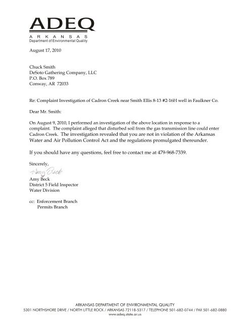
August 17, 2010<br />
Chuck Smith<br />
DeSoto Gather<strong>in</strong>g Company, LLC<br />
P.O. Box 789<br />
Conway, AR 72033<br />
Re: Compla<strong>in</strong>t Investigation of <strong>Cadron</strong> <strong>Creek</strong> near Smith Ellis 8-13 #2-16H well <strong>in</strong> Faulkner Co.<br />
Dear Mr. Smith:<br />
On August 9, 2010, I performed an <strong><strong>in</strong>vestigation</strong> of the above location <strong>in</strong> response to a<br />
compla<strong>in</strong>t. <strong>The</strong> compla<strong>in</strong>t alleged <strong>that</strong> disturbed soil from the gas transmission l<strong>in</strong>e could enter<br />
<strong>Cadron</strong> <strong>Creek</strong>. <strong>The</strong> <strong><strong>in</strong>vestigation</strong> <strong>revealed</strong> <strong>that</strong> <strong>you</strong> <strong>are</strong> <strong>not</strong> <strong>in</strong> violation of the Arkansas<br />
Water and Air Pollution Control Act and the regulations promulgated thereunder.<br />
If <strong>you</strong> should have any questions, feel free to contact me at 479-968-7339.<br />
S<strong>in</strong>cerely,<br />
Amy Beck<br />
District 5 Field Inspector<br />
Water Division<br />
cc: Enforcement Branch<br />
Permits Branch
FOR OFFICE USE ONLY:<br />
AIR HW RST SW WATER MINING<br />
ARKANSAS DEPARTMENT OF ENVIRONMENTAL QUALITY<br />
5301 Northshore Drive, North Little Rock, AR 72118<br />
COMPLAINT REPORT<br />
GPS: 35° 20’ 9.34”N, 92° 22’ 35.13”W (estimated) AFIN#: NA PERMIT#: NA<br />
DATE RECEIVED: August 3, 2010 COUNTY: Faulkner<br />
COMPLAINANT NAME: Mike Coagan COMPLAINT AGAINST: DeSoto Gather<strong>in</strong>g Co.<br />
ADDRESS: ADDRESS: P.O. Box 789, Conway, AR 72032<br />
PHONE: 501-681-2314 PHONE: 501-335-0183 FAX: 501-335-0152<br />
PERSON RECEIVING REPORT:<br />
INSPECTOR REFERRED:<br />
PHONE REFERRAL CONTACT:<br />
DESCRIPTION (IN DETAIL)<br />
DATE:<br />
DATE:<br />
DATE:<br />
SUPERVISOR REFERRAL:<br />
MEDIA SUPERVISOR REFERRAL:<br />
RECEIVING INSPECTOR:<br />
Amy Beck<br />
DATE:<br />
DATE:<br />
DATE:<br />
8/3/2010<br />
Transmission l<strong>in</strong>e for the Smith Ellis 8-13 #2-16H gas well has been dug and is <strong>not</strong> stabilized. <strong>The</strong>re is no silt<br />
fence <strong>in</strong>stalled and the <strong>are</strong>a dra<strong>in</strong>s to <strong>Cadron</strong> <strong>Creek</strong>.<br />
LOCATION (IN DETAIL)<br />
NW of Guy, AR, go west on <strong>Cadron</strong> Lane until end at well access road, cont<strong>in</strong>ue west to the site.<br />
PREVIOUS COMPLAINT? G YES NO DATES:<br />
DISCHARGE TO STREAM? G YES NO NAME OF STREAM:<br />
HOW COMPLAINT WAS RECEIVED: PHONE G LETTER G VERBAL G FAX G E-MAIL<br />
Page 2
FOLLOW UP ON COMPLAINT<br />
COMPLAINT #: AFIN #:NA<br />
INSPECTOR: Amy Beck DATE: 8/9/2010<br />
ACTION TAKEN: PHOTOS TAKEN: Yes<br />
Arriv<strong>in</strong>g at the site I observed the transmission pipe has been <strong>in</strong>stalled but the well has <strong>not</strong> been hooked<br />
on. Soil has been disturbed on the west and north sides of the Smith Ellis 8-13 #2-16H well. Although I<br />
did <strong>not</strong> see silt fence, two diversion dikes were <strong>in</strong>stalled on the north side of the pad. Review of aerial<br />
photos show the <strong>are</strong>a was terraced prior to the well pad construction and some of the terrac<strong>in</strong>g rema<strong>in</strong>s<br />
<strong>in</strong>tact between the pipel<strong>in</strong>e and <strong>Cadron</strong> <strong>Creek</strong>. I did <strong>not</strong> observe soil erod<strong>in</strong>g from the pipel<strong>in</strong>e right-ofway.<br />
It is approximately 450 feet from the disturbed soil (west of the pad) to <strong>Cadron</strong> <strong>Creek</strong> and there is<br />
m<strong>in</strong>imal potential for soil to enter the creek.<br />
On August 12, 2010 I telephoned the compla<strong>in</strong>ant, Mr. Coagan, and <strong>in</strong>formed him of my f<strong>in</strong>d<strong>in</strong>gs.<br />
FURTHER ACTION TAKEN/TO BE TAKEN:<br />
None.<br />
INSPECTOR SIGNATURE:<br />
DATE: 8-9-10 HOURS WORKED: 1.0<br />
Page 3
Arkansas Department of Environmental Quality (ADEQ)<br />
Official Photograph Sheet<br />
Location: DGC transmission l<strong>in</strong>e from the Smith Ellis 8-13 #2-16H well off <strong>Cadron</strong> Lane <strong>in</strong> Faulkner Co.<br />
Photographer: Amy Beck Witness: None<br />
Photo # 1 Of 2 Date: 8-9-10 Time: 1432<br />
Description: Disturbed soil observed west of the well pad. Note the terrac<strong>in</strong>g on the right side of the photo.<br />
Photographer: Amy Beck Witness: None<br />
Photo # 2 Of 2 Date: 8-9-10 Time: 1423<br />
Description: <strong>Cadron</strong> <strong>Creek</strong> as observed on the day of this <strong><strong>in</strong>vestigation</strong> down slope of the transmission pipe.<br />
Page 4