

Section 2 - Characteristics of the Area - Kildare.ie
Section 2 - Characteristics of the Area - Kildare.ie
Section 2 - Characteristics of the Area - Kildare.ie

You also want an ePaper? Increase the reach of your titles
YUMPU automatically turns print PDFs into web optimized ePapers that Google loves.
DONAGHCUMPER LANDS / CELBRIDGE TOWN CENTRE ACTION AREA PLAN<br />
SECTION 2: <strong>Characteristics</strong> <strong>of</strong> <strong>the</strong> <strong>Area</strong><br />
2.1 Features <strong>of</strong> <strong>the</strong> Site<br />
This Plan appl<strong>ie</strong>s to Celbridge Main Street and its immediate<br />
hinterland and <strong>the</strong> Donaghcumper lands that l<strong>ie</strong> on <strong>the</strong> opposite<br />
bank <strong>of</strong> <strong>the</strong> River Liffey.<br />
The Donaghcumper lands were until recently used as a riding<br />
school and are largely kept as open grassland.<br />
In total, <strong>the</strong> Donaghcumper lands extend to 39 hectares in area.<br />
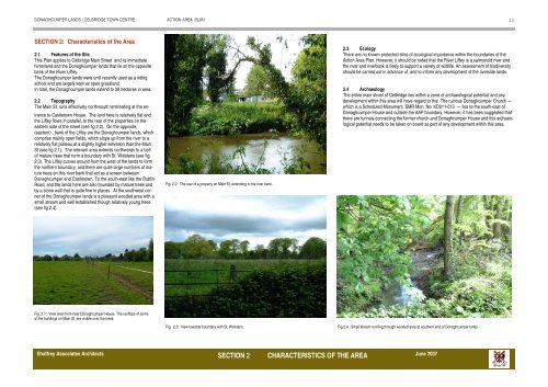
2.2 Topography<br />
The Main St. runs effectively north-south terminating at <strong>the</strong> entrance<br />
to Castletown House. The land here is relatively flat and<br />
<strong>the</strong> Liffey flows in parallel, to <strong>the</strong> rear <strong>of</strong> <strong>the</strong> propert<strong>ie</strong>s on <strong>the</strong><br />
eastern side <strong>of</strong> <strong>the</strong> street (see fig 2.2). On <strong>the</strong> opposite,<br />
(eastern) , bank <strong>of</strong> <strong>the</strong> Liffey are <strong>the</strong> Donaghcumper lands, which<br />
comprise mainly open f<strong>ie</strong>lds, which slope up from <strong>the</strong> river to a<br />
relatively flat plateau at a slightly higher elevation than <strong>the</strong> Main<br />
St (see fig 2.1). The relevant area extends northwards to a belt<br />
<strong>of</strong> mature trees that form a boundary with St. Wolstans (see fig.<br />
2.3). The Liffey curves around from <strong>the</strong> west <strong>of</strong> <strong>the</strong> lands to form<br />
<strong>the</strong> nor<strong>the</strong>rn boundary, and <strong>the</strong>re are quite large numbers <strong>of</strong> mature<br />
trees on this river bank that act as a screen between<br />
Donaghcumper and Castletown. To <strong>the</strong> south-east l<strong>ie</strong>s <strong>the</strong> Dublin<br />
Road, and <strong>the</strong> lands here are also bounded by mature trees and<br />
by a stone wall that is quite fine in places. At <strong>the</strong> southwest corner<br />
<strong>of</strong> <strong>the</strong> Donaghcumper lands is a pleasant wooded area with a<br />
small stream and well established though relatively young trees<br />
(see fig 2.4).<br />
Fig. 2.1: V<strong>ie</strong>w west from near Donaghcumper House. The ro<strong>of</strong>tops <strong>of</strong> some<br />
<strong>of</strong> <strong>the</strong> buildings on Main St. are visible over <strong>the</strong> trees.<br />
Fig. 2.2: The rear <strong>of</strong> a property on Main St. extending to <strong>the</strong> river bank.<br />
Fig. 2.3: V<strong>ie</strong>w towards boundary with St. Wolstans.<br />
Shaffrey Associates Architects June 2007<br />
SECTION 2 CHARACTERISTICS OF THE AREA<br />
2.3 Ecology<br />
There are no known protected sites <strong>of</strong> ecological importance within <strong>the</strong> boundar<strong>ie</strong>s <strong>of</strong> <strong>the</strong><br />
Action <strong>Area</strong> Plan. However, it should be noted that <strong>the</strong> River Liffey is a salmonoid river and<br />
<strong>the</strong> river and riverbank is likely to support a var<strong>ie</strong>ty <strong>of</strong> wildlife. An assessment <strong>of</strong> biodiversity<br />
should be carr<strong>ie</strong>d out in advance <strong>of</strong>, and to inform any development <strong>of</strong> <strong>the</strong> riverside lands.<br />
2.4 Archaeology<br />
The entire main street <strong>of</strong> Celbridge l<strong>ie</strong>s within a zone <strong>of</strong> archaeological potential and any<br />
development within this area will have regard to this. The ruinous Donaghcumper Church —<br />
which is a Scheduled Monument, SMR Mon. No. KD011-013 — l<strong>ie</strong>s to <strong>the</strong> south-east <strong>of</strong><br />
Donaghcumper House and outside <strong>the</strong> AAP boundary. However, it has been suggested that<br />
<strong>the</strong>re are tunnels connecting <strong>the</strong> former church and Donaghcumper House and this archaeological<br />
potential needs to be taken on board as part <strong>of</strong> any development within this area.<br />
Fig 2.4: Small stream running through wooded area at sou<strong>the</strong>rn end <strong>of</strong> Donaghcumper lands<br />
11
DONAGHCUMPER LANDS / CELBRIDGE TOWN CENTRE ACTION AREA PLAN<br />
2.5 Architectural Features<br />
Existing Town Centre<br />
Celbridge town centre is <strong>of</strong> an essentially classical character, laid out along <strong>the</strong> typical linear plan,<br />
with buildings <strong>of</strong> relatively narrow frontage and long back areas, facing <strong>the</strong> Main St. and extending<br />
out along <strong>the</strong> Maynooth and Clane Roads. The buildings are small in scale, mostly two-storey<br />
houses and shops (see `figs. 2.5, 2.6), but here and <strong>the</strong>re are landmark buildings such as<br />
churches (see fig. 2.7), Celbridge Mills and large houses—Kildought House and Celbridge Lodge,<br />
for example. These changes in scale and setting add var<strong>ie</strong>ty to <strong>the</strong> townscape. Many <strong>of</strong> <strong>the</strong> buildings/structures<br />
are Protected Structures, <strong>of</strong> local, regional, national and international importance.<br />
The area also includes settled residential areas.<br />
Castletown House and Demesne<br />
Castletown House and Demesne, while not within <strong>the</strong> Plan area, must be considered in relation to<br />
any development <strong>of</strong> Celbridge town, as it is <strong>of</strong> international significance. Among <strong>the</strong> more important<br />
aspects <strong>of</strong> <strong>the</strong> large country house is its setting and grounds and this is particularly true in regard<br />
to Castletown. It is <strong>the</strong> largest country house in Ireland, dating from <strong>the</strong> early 18th century<br />
(c.1722). Laid out in a Palladian manner, it was designed by Alexander Galilei and since construction<br />
until relatively recently it remained a family home and has retained its original character.<br />
The house and its original demesne still largely remains. Castletown House is now owned by <strong>the</strong><br />
State and is maintained and managed by <strong>the</strong> OPW. It must be noted that v<strong>ie</strong>ws to and from <strong>the</strong><br />
house were carefully considered in <strong>the</strong> original planning and siting <strong>of</strong> <strong>the</strong> house and due consideration<br />
should be given to <strong>the</strong> protection <strong>of</strong> <strong>the</strong>se v<strong>ie</strong>ws when considering any future developments.<br />
Donaghcumper House<br />
Donaghcumper House is an architecturally important house dating from <strong>the</strong> 18th century originally,<br />
but significantly enlarged and remodelled in a Tudor Revival style circa 1835. The entrance hall,<br />
stairs and living rooms are particularly fine with high quality joinery and plaster work. It has an<br />
interesting range <strong>of</strong> outbuildings, walled orchard, and gardens. The formal gardens and fine v<strong>ie</strong>ws<br />
towards Castletown House are a feature <strong>of</strong> Donaghcumper and <strong>the</strong> relationship between <strong>the</strong> two<br />
demesnes should be retained as part <strong>of</strong> any new development.. The implementation <strong>of</strong> <strong>the</strong> Plan<br />
will change <strong>the</strong> context that <strong>the</strong> house has enjoyed over <strong>the</strong> years – that is <strong>of</strong> a large house in a<br />
farmland setting (see figs. 2.11 & 2.12). It is important that <strong>the</strong> immediate setting <strong>of</strong> <strong>the</strong> house is<br />
protected and, in particular, to enable it to have an appropriate future use reflecting its architectural<br />
and historic character. The historic demesne should be fully surveyed and surviving designed<br />
landscape features <strong>of</strong> significance protected and incorporated within any development.<br />
Donaghcumper House is presently not a Protected Structure, however it is recommended that it<br />
be added to <strong>Kildare</strong> County Council’s Record <strong>of</strong> Protected Structures.<br />
Fig 2.5: Celbridge Main St.<br />
Fig. 2.8: Kildrought House, a<br />
fine house set back from <strong>the</strong><br />
Main Street adds var<strong>ie</strong>ty and<br />
character to <strong>the</strong> streetscape.<br />
Fig 2.6: Typical two-storey streetscape <strong>of</strong> Celbridge<br />
Fig. 2.7: The set back <strong>of</strong> <strong>the</strong> church from <strong>the</strong> building line on Main St. provides<br />
a place for <strong>the</strong> public to ga<strong>the</strong>r.<br />
Fig. 2.11 (above): Donaghcumper House v<strong>ie</strong>wed from Celbridge Avenue.<br />
Fig. 2.12 (right): Donaghcumper House—garden (wouth-west) façade,<br />
Shaffrey Associates Architects June 2007<br />
SECTION 2 CHARACTERISTICS OF THE AREA<br />
Fig. 2.10: Entrance gates and associated buildings <strong>of</strong> Castletown House –<br />
all Protected Structures <strong>of</strong> International Importance.<br />
12<br />
Fig. 2.9: Fine v<strong>ie</strong>w from upper floor <strong>of</strong> Castletown House looking eastward.<br />
AAP area is to <strong>the</strong> right <strong>of</strong> <strong>the</strong> middle ground, amongst <strong>the</strong> trees.


