The impact of subdivision and sedentarization of ... - Land Portal
The impact of subdivision and sedentarization of ... - Land Portal
The impact of subdivision and sedentarization of ... - Land Portal

You also want an ePaper? Increase the reach of your titles
YUMPU automatically turns print PDFs into web optimized ePapers that Google loves.
2540 D. Western et al. / Biological Conservation 142 (2009) 2538–2546<br />
<strong>subdivision</strong> on 17 large herbivore species using before <strong>and</strong> after<br />
measures on adjacent subdivided <strong>and</strong> un-subdivided ranches.<br />
<strong>The</strong> species counted included zebra (Equus burchelli), wildebeest<br />
(Connochaetes taurinus), kongoni (Alcelaphus buselaphus), Thompson’s<br />
gazelle (Gazella thomsonii), Grant’s gazelle (Gazella granti),<br />
impala (Aepyceros melampus), oryx (Oryx beisa), el<strong>and</strong> (Taurotragus<br />
oryx), buffalo (Syncerus caffer), elephant (Loxodonta africana), giraffe<br />
(Giraffa cameleopardis), ostrich (Struthio camelus), gerenuk<br />
(Litocranius walleri), black rhino (Diceros bicornis), warthog (Phacochoerus<br />
africana), lesser kudu (Tragelaphus imberbis), <strong>and</strong> waterbuck<br />
(Kobus ellipsiprymnus).<br />
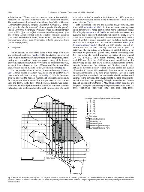
1.1. Study area<br />
<strong>The</strong> 14 sections <strong>of</strong> Maasail<strong>and</strong> cover a wide range <strong>of</strong> climatic<br />
<strong>and</strong> ecological conditions (Jacobs, 1965). Subdivision has occurred<br />
in the wetter rather than drier portions <strong>of</strong> the rangel<strong>and</strong>s, introducing<br />
an ecological bias into a comparative study <strong>of</strong> the <strong>impact</strong><br />
<strong>of</strong> <strong>sedentarization</strong> on savanna ecosystems. To minimize this bias,<br />
we studied two adjacent sections <strong>of</strong> Maasail<strong>and</strong>, Kaputei <strong>and</strong> Ilkisongo,<br />
both in eastern Kajiado District, southern Kenya (Fig. 1).<br />
<strong>The</strong> two ranches share a similar climate <strong>and</strong> ecology (Groom,<br />
2007). Aerial counts <strong>of</strong> eastern Kajiado by one <strong>of</strong> us (DW) have<br />
been conducted since the early 1970s (Fig. 1). Within the count<br />
area we selected the Kaputei ranches <strong>and</strong> Mbirikani group ranch<br />
for comparison. Mobile pastoralism was practiced on both ranches<br />
until the 1970s. In the late 1970s, however, Kaputei was subdivided<br />
into individual private ranches. Mbirikani remained communal<br />
<strong>and</strong> open to herders <strong>and</strong> wildlife, with the exception <strong>of</strong> a small<br />
strip in the west <strong>of</strong> the ranch. In that strip, in the 1980s, a number<br />
<strong>of</strong> families voluntarily settled along the Loitokitok–Sultan Hamud<br />
water pipeline (Fig. 2).<br />
Both ranches are semi-arid <strong>and</strong> classified as Agroclimatic Zones<br />
V <strong>and</strong> VI (Sombroek et al., 1982). In Amboseli, mean monthly maximum<br />
temperatures range from the mid-30s °C in February to low<br />
20s °C in July (Altmann et al., 2002). No in situ climate records are<br />
available due to the dearth <strong>of</strong> climate stations in the study area. To<br />
characterize the rainfall patterns in the two areas we used satellite<br />
derived rainfall estimates generated from cold cloud duration <strong>and</strong><br />
rainfall station data (African Data Dissemination Service http://earlywarning.usgs.gov/adds/).<br />
Rainfall on both ranches ranged between<br />
350 <strong>and</strong> 700 mm annually over the last 12 years. To<br />
determine the magnitude <strong>of</strong> difference in rainfall between the<br />
two areas we performed a paired t-test, further calculating an effect<br />
size using the pooled st<strong>and</strong>ard deviation <strong>of</strong> total annual<br />
(t = 1.14, p = 0.277) <strong>and</strong> mean monthly rainfall (t = 0.76,<br />
p = 0.461). An effect size <strong>of</strong> 0.116 for annual rainfall indicated a<br />
non-overlap <strong>of</strong> less than 14.7% in mean annual rainfall distributions<br />
in the two areas (over 85% overlap). Similarly, an effect size<br />
<strong>of</strong> 0.06 for the mean monthly rainfall indicated a small non-overlap<br />
<strong>of</strong> less that 7.7% (over 92% overlap) in the mean month by month<br />
rainfall distributions in the two group ranches. <strong>The</strong>re is a slight<br />
rainfall gradient across both ranches associated with the Ukambani<br />
upl<strong>and</strong>s to the north <strong>and</strong> the Chyulu Hills to the east. Rainfall is bimodal,<br />
with short rains generally falling in November <strong>and</strong> December<br />
<strong>and</strong> long rains from March to May (Ntiati, 2002). Droughts are<br />
frequent. During the past century droughts were recorded in 1933–<br />
1935, 1943–1946, 1948–1949, 1952–1953, 1960–1961, 1972–<br />
Fig. 2. Map <strong>of</strong> the study area showing the 5 5 km grids covered in aerial counts <strong>of</strong> eastern Kajiado since 1973 <strong>and</strong> the boundaries <strong>of</strong> the two study ranches, Kaputei <strong>and</strong><br />
Mbirikani, relative to Amboseli National Park. <strong>The</strong> voluntarily settled portion <strong>of</strong> Mbirikani is shown along the pipeline together with the density <strong>and</strong> dispersal <strong>of</strong> settlements<br />
on both ranches.