The Role of Downhole Measurements in Marine Geology and ...
The Role of Downhole Measurements in Marine Geology and ...
The Role of Downhole Measurements in Marine Geology and ...

You also want an ePaper? Increase the reach of your titles
YUMPU automatically turns print PDFs into web optimized ePapers that Google loves.
35, 3 /REVIEWS OF GEOPHYSICS Goldberg: DOWNHOLE MEASUREMENTS ß 329<br />
I,I<br />
175.3 -<br />
175.4 -<br />
175.5 -<br />
CORE<br />
PHOTOGRAPH<br />
FMS<br />
ORIENTATION<br />
0 60 120 180 240 300 360<br />
- 174<br />
- 175<br />
- 176<br />
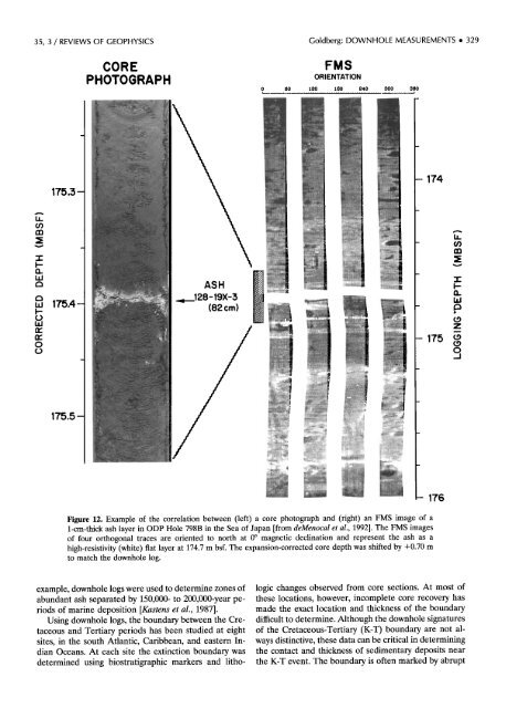
Figure 12. Example <strong>of</strong> the correlation between (left) a core photograph <strong>and</strong> (right) an FMS image <strong>of</strong> a<br />
l-cm-thick ash layer <strong>in</strong> ODP Hole 798B <strong>in</strong> the Sea <strong>of</strong> Japan [from deMenocal e! al., 1992]. <strong>The</strong> FMS images<br />
<strong>of</strong> four orthogonal traces are oriented to north at 0 ø magnetic decl<strong>in</strong>ation <strong>and</strong> represent the ash as a<br />
high-resistivity (white) fiat layer at 174.7 m bsf. <strong>The</strong> expansion-corrected core depth was shifted by +0.70 m<br />
to match the downhole log. .<br />
example, downhole logs were used to determ<strong>in</strong>e zones <strong>of</strong> logic changes observed from core sections. At most <strong>of</strong><br />
abundant ash separated by 150,000- to 200,000-year pe- these locations, however, <strong>in</strong>complete core recovery has<br />
riods <strong>of</strong> mar<strong>in</strong>e deposition [Kastens et al., 1987]. made the exact location <strong>and</strong> thickness <strong>of</strong> the boundary<br />
Us<strong>in</strong>g downhole logs, the boundary between the Cre- difficult to determ<strong>in</strong>e. Although the downhole signatures<br />
taceous <strong>and</strong> Tertiary periods has been studied at eight <strong>of</strong> the Cretaceous-Tertiary (K-T) boundary are not alsites,<br />
<strong>in</strong> the south Atlantic, Caribbean, <strong>and</strong> eastern In- ways dist<strong>in</strong>ctive, these data can be critical <strong>in</strong> determ<strong>in</strong><strong>in</strong>g<br />
dian Oceans. At each site the ext<strong>in</strong>ction boundary was the contact <strong>and</strong> thickness <strong>of</strong> sedimentary deposits near<br />
determ<strong>in</strong>ed us<strong>in</strong>g biostratigraphic markers <strong>and</strong> litho- the K-T event. <strong>The</strong> boundary is <strong>of</strong>ten marked by abrupt<br />
LI.I