Come - Desert Magazine of the Southwest
Come - Desert Magazine of the Southwest
Come - Desert Magazine of the Southwest

You also want an ePaper? Increase the reach of your titles
YUMPU automatically turns print PDFs into web optimized ePapers that Google loves.
There are a myriad <strong>of</strong> <strong>of</strong>f-road tracks<br />
leading north and south from <strong>the</strong> Bradshaw<br />
as we head west toward <strong>the</strong> Salton<br />
Sea. But be careful, this again is restricted<br />
travel country under <strong>the</strong> BLM banner<br />
— stay on <strong>the</strong> main road—and tracks to<br />
<strong>the</strong> south head into <strong>the</strong> Navy's Chocolate<br />
Mountains Aerial Gunnery Range, a nono.<br />
The range's boundary is poorly posted<br />
but fairly well patrolled, so stay out;<br />
besides <strong>the</strong>y may drop things on you,<br />
like 500-pound bombs, rockets or o<strong>the</strong>r<br />
hardware.<br />
Two trails to <strong>the</strong> north, however, are<br />
alluring, and legal. The first, when measured<br />
west about 19 miles from Wiley<br />
Well, is <strong>the</strong> Graham Pass Road we mentioned<br />
before. The second, ano<strong>the</strong>r 20<br />
miles, give or take a kilometer, is <strong>the</strong><br />
faint track leading upgrade to old Gulliday<br />
Well, one <strong>of</strong> <strong>the</strong> original watering<br />
sites for wagoneers more than a century<br />
ago. Many old mines dot <strong>the</strong> sou<strong>the</strong>rn<br />
slope <strong>of</strong> <strong>the</strong> Chuckawallas.<br />
The old Beal Well section <strong>of</strong> <strong>the</strong> Niland-Bly<strong>the</strong><br />
road, south from <strong>the</strong> Graham<br />
Pass Junction, is now closed by <strong>the</strong><br />
Navy. This crossing <strong>of</strong> <strong>the</strong> Chocolates<br />
reaches into historic bighorn sheep and<br />
desert mule deer range, now <strong>of</strong>f-limits.<br />
The present State Highway 78, by way<br />
<strong>of</strong> Glamis and <strong>the</strong> Imperial Sand Dunes,<br />
was opened as a substitute for <strong>the</strong> old<br />
road after World War II, due in part to<br />
pressure by Imperial and Riverside<br />
counties applied to <strong>the</strong> Navy for closing a<br />
vital travel route. New 78 <strong>of</strong>fers plenty <strong>of</strong><br />
history and scenery in its own right.<br />
Perhaps five miles west <strong>of</strong> <strong>the</strong><br />
Gulliday junction <strong>the</strong> Bradshaw makes a<br />
definite split. The left or northbound<br />
fork, along a utility pole line, is <strong>the</strong><br />
sou<strong>the</strong>rn extension <strong>of</strong> <strong>the</strong> Red Cloud<br />
Road, which reaches 1-10 midway between<br />
Chiriaco Summit and <strong>Desert</strong> Center.<br />
If you're tired <strong>of</strong> <strong>the</strong> whole thing,<br />
this is a good place to cut for civilization,<br />
but I think some <strong>of</strong> <strong>the</strong> best scenery is<br />
just ahead in Salt Creek Wash.<br />
Red Cloud Road, as its name implies,<br />
reaches <strong>the</strong> historic Red Cloud Mine,<br />
also <strong>the</strong> Great Western, above <strong>the</strong> Red<br />
Cloud, and a number <strong>of</strong> old diggings<br />
along <strong>the</strong> fairly well-maintained road.<br />
There are lots more <strong>of</strong> those keep-out<br />
signs along here, however. The road is<br />
public.<br />
J ust west <strong>of</strong> <strong>the</strong> pole line junction <strong>the</strong><br />
Bradshaw meets ano<strong>the</strong>r branch, a faint<br />
track to <strong>the</strong> south along <strong>the</strong> Chocolates.<br />
<strong>Desert</strong>/Acril 1979<br />
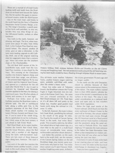
Historic Midway Well, midway between BIy<strong>the</strong> and Brawley on <strong>the</strong> old Glamis<br />
mining and freighting road. The rock protective works around <strong>the</strong> old hand-dug casing<br />
has been badly eroded by heavy flooding through Milpitas Wash in recent years.<br />
This <strong>of</strong>f-limits route reaches Tabaseco<br />
Tanks, ano<strong>the</strong>r historic wagon watering<br />
point, probably well-filled with water<br />
after <strong>the</strong> winter's heavy rains.<br />
About five miles west <strong>of</strong> Tabaseco<br />
branch, <strong>the</strong> Bradshaw crosses <strong>the</strong> Flying<br />
Eagle or Eagle Mountain iron ore railroad<br />
<strong>of</strong> <strong>the</strong> Kaiser Steel Corp., <strong>the</strong> same<br />
line you crossed yesterday at <strong>the</strong><br />
Red Cloud overpass on 1-10. From here<br />
on it's all down hill and pretty to <strong>the</strong><br />
Salton Sea. Ano<strong>the</strong>r good graded road<br />
heads north along <strong>the</strong> railroad to 1-10,<br />
some 12 miles.<br />
To <strong>the</strong> left, however, <strong>the</strong> route is down<br />
Salt Creek Wash, paralleling <strong>the</strong> railroad<br />
to <strong>the</strong> mouth <strong>of</strong> <strong>the</strong> gorge 10 miles.<br />
You'll go by <strong>the</strong> mouth <strong>of</strong> Canyon Spring<br />
Wash, to <strong>the</strong> north, four miles downgrade.<br />
This is worth a side trip, for ei<strong>the</strong>r<br />
four-wheel-drive or high-center rigs, or a<br />
short hike to <strong>the</strong> pool in a multi-hued<br />
canyon <strong>of</strong> considerable fame among<br />
rockhounders and o<strong>the</strong>r desert denizens.<br />
Just below <strong>the</strong> junction, on <strong>the</strong> wash<br />
bank to <strong>the</strong> south (left), are <strong>the</strong> remains<br />
<strong>of</strong> <strong>the</strong> Canyon Spring station on <strong>the</strong> old<br />
Bradshaw stage, now merely some scattered<br />
rocks very hard to find. Two miles<br />
down canyon you'll spot demons Well,<br />
ano<strong>the</strong>r freighting water point, drilled by<br />
<strong>the</strong> county government 70 years ago and<br />
no longer usable.<br />
To <strong>the</strong> north are <strong>the</strong> arid Orocopias,<br />
closed to vehicles because <strong>of</strong> <strong>the</strong>ir<br />
unique place in <strong>the</strong> contemporary history<br />
<strong>of</strong> <strong>the</strong> nation. The moon walkers trained<br />
here in <strong>the</strong>ir 4WD electric vehicles because<br />
<strong>of</strong> <strong>the</strong> terrain's resemblance to <strong>the</strong><br />
surface <strong>of</strong> <strong>the</strong> moon. The area is now<br />
under consideration as a national landmark<br />
and open only to foot travelers<br />
under BLM regulations.<br />
Below <strong>the</strong> high steel trestle <strong>of</strong> <strong>the</strong><br />
Kaiser railroad, which hauls ore from <strong>the</strong><br />
mine northwest <strong>of</strong> <strong>Desert</strong> Center to <strong>the</strong><br />
steel mill at Fontana, <strong>the</strong> canyon widens<br />
out and <strong>the</strong> road soon crosses through<br />
<strong>the</strong> All-American canal at a flood control<br />
siphon and our route reaches civilization<br />
and <strong>the</strong> pavement along <strong>the</strong> canal service<br />
road to Parkside Drive. You reach<br />
Highway 111 opposite <strong>the</strong> main entrance<br />
to <strong>the</strong> Salton Sea State Recreation Area<br />
where a fine interpretive or visitors center<br />
may help tell you what you've been<br />
seeing <strong>the</strong> past two days.<br />
From here it's only 25 easy miles back<br />
to our starting place at Indio, and from<br />
<strong>the</strong>re it's only 125 miles to <strong>the</strong> four-level<br />
interchange in downtown Los Angeles.<br />
Hope you have a good time! D<br />
23