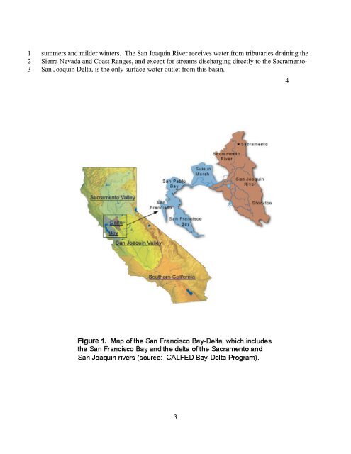
1 2 3 summers and milder winters. The San Joaquin River receives water from tributaries draining <strong>the</strong> Sierra Nevada and Coast Ranges, and except <strong>for</strong> streams discharging directly to <strong>the</strong> Sacramento- San Joaquin <strong>Delta</strong>, is <strong>the</strong> only surface-water outlet from this basin. 3 4 5
1 2 3 4 5 6 7 8 9 10 11 12 13 14 15 16 17 18 19 20 21 22 23 24 25 26 27 28 29 30 31 32 33 34 35 36 37 38 39 40 41 42 43 The modern San Francisco <strong>Bay</strong> can be characterized as an ecologically young, but extensively modified, estuarine ecosystem. The estuary was <strong>for</strong>med 15,000 to 18,000 years ago, when rising sea waters from glacial melting entered <strong>the</strong> Golden Gate, inundating what are now <strong>the</strong> major embayments of <strong>the</strong> San Francisco <strong>Bay</strong> (San Pablo <strong>Bay</strong>, Carquinez Strait, Suisan <strong>Bay</strong>, Grizzly <strong>Bay</strong>, Honker <strong>Bay</strong>), trans<strong>for</strong>ming a riverine system into an extensive and complex estuary (Atwater 1979). Toge<strong>the</strong>r, <strong>the</strong> Sacramento-San Joaquin <strong>Delta</strong> and <strong>the</strong> embayments of San Francisco <strong>Bay</strong> <strong>for</strong>m <strong>the</strong> largest estuary on <strong>the</strong> West Coast of <strong>the</strong> United States, with a combined area of about 3000 square kilometers. The <strong>Delta</strong> is estuarine through its lower end, but is almost completely influenced by tidal cycles. About 72 percent of <strong>the</strong> <strong>Delta</strong> land area is in agricultural production, which was engineered via a complex system of dikes, drainage ditches, irrigation diversions, pumps, and floodgates. This complex drainage pattern combined with a strong tidal currents create large tidal excursions, where distinct water parcels, with distinct chemical characteristics, can travel many miles on a given ebb or flood tide in patterns that are difficult to predict or anticipate. Freshwater inflows (excluding precipitation) to <strong>the</strong> <strong>Delta</strong> are mainly from <strong>the</strong> Sacramento River (about 75-80 percent), with most of this inflow during January to April. Mining and <strong>Mercury</strong> The mountain ranges that surround Cali<strong>for</strong>nia’s Central Valley and drain into <strong>the</strong> Sacramento and San Joaquin watersheds contain extensive mineral deposits. Discovery of gold deposits in <strong>the</strong> Klamath Mountains and Sierra Nevada stimulated <strong>the</strong> Cali<strong>for</strong>nia Gold Rush in 1848, and an abundance of mercury – mined from deposits in <strong>the</strong> Coast Ranges – facilitated <strong>the</strong> rapid historic proliferation of gold-mining operations (Figure 2) that used <strong>the</strong> mercury-amalgamation process to extract gold (Alpers and Hunerlach 2000). Hundreds of hydraulic gold-placer mines operated on <strong>the</strong> east side of <strong>the</strong> Central Valley, where tens of millions of cubic meters of rock and earth were excavated annually by hydraulic mining. The resulting mining debris choked streams and rivers downstream of mining sites, and in some cases valleys were nearly filled with debris. About 100,000 metric tons of mercury were produced by mercury-mining operations in <strong>the</strong> Coast Ranges, and about 12,000 metric tons of this were used in gold mining in Cali<strong>for</strong>nia, with annual losses at mine sites ranging from about 10 to 30 percent of <strong>the</strong> mercury used (Alpers and Hunerlach 2000). The effects of <strong>the</strong>se mining activities are evident in <strong>the</strong> <strong>Bay</strong>-<strong>Delta</strong> estuary far downstream (Conomos et al. 1985). Consequently, mercury from a mineral belt associated with Cenozoic hydro<strong>the</strong>rmal deposits in <strong>the</strong> Coast Ranges (Rytuba 1996) now contaminates environments extending from San Francisco <strong>Bay</strong> (Hornberger et al. 1999) to <strong>the</strong> Sierra Nevada and far beyond (Schuster et al. 2002). The accumulation of contaminated debris from gold mining caused a notable loss of depth in parts of <strong>the</strong> San Francisco <strong>Bay</strong> (Nichols et al. 1986, Cappiella et al. 1999). In <strong>the</strong> past 50 years, however, <strong>the</strong> amount of additional sedimentation attributable to <strong>the</strong> Gold Rush has declined substantially, and fur<strong>the</strong>r declines are predicted (Jaffee et al. 1998). All of <strong>the</strong> major rivers in <strong>the</strong> Sacramento River basin (Sacramento, Fea<strong>the</strong>r, American, Yuba) are impounded. The impoundments have decreased sediment export from <strong>the</strong> basin (Goals Project 1999), and <strong>the</strong> suspended sediment load of <strong>the</strong> Sacramento River has declined since 1960 (Krone 1996). Given that about 90 percent of <strong>the</strong> total mercury load to <strong>the</strong> <strong>Bay</strong>-<strong>Delta</strong> ecosystem from <strong>the</strong> Sacramento River is sediment borne (Foe 2002), it can be reasonably inferred that mercury loads have correspondingly declined and that future activities affecting sediment budgets could substantially 4