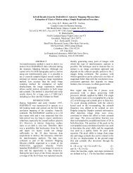
Synthetic Aperture Radar for Search and Rescue: Evaluation of ...
Synthetic Aperture Radar for Search and Rescue: Evaluation of ...
Synthetic Aperture Radar for Search and Rescue: Evaluation of ...

You also want an ePaper? Increase the reach of your titles
YUMPU automatically turns print PDFs into web optimized ePapers that Google loves.
Preprint/Prétirage<br />
<strong>Synthetic</strong> <strong>Aperture</strong> <strong>Radar</strong> <strong>for</strong> <strong>Search</strong> <strong>and</strong> <strong>Rescue</strong>: <strong>Evaluation</strong> <strong>of</strong><br />
Advanced Capabilities in Preparation <strong>for</strong> RADARSAT-2<br />
Tom I. Lukowski 1 , Fakhry Khellah 2 , François J. Charbonneau 3 , <strong>and</strong> Bing Yue 2<br />
1 Canada Centre <strong>for</strong> Remote Sensing, Natural Resources Canada 588 Booth St. Ottawa, Canada<br />
K1A 0Y7 Phone: (613) 995-0386 Fax: (613) 947-1383 Email: tom.lukowski@ccrs.nrcan.gc.ca<br />
2 NOETIX Research Inc., 265 Carling Avenue, Suite 403, Ottawa, Canada K1S 2E1<br />
Phone: (613) 236-1555 Fax: (613) 236-1870 (Under contract to CCRS)<br />
3 ISOSCELES In<strong>for</strong>mation Solutions Inc., 201-1128 Church St., Manotick, Canada K4M 1A3<br />
Phone: (613) 995-9034 Fax: (613) 947-1383 (Under contract to CCRS)<br />
ABSTRACT<br />
Researchers at the Canada Centre <strong>for</strong> Remote Sensing <strong>of</strong> Natural Resources Canada are exploring the use <strong>of</strong> remotely<br />
sensed imagery to assist <strong>Search</strong> <strong>and</strong> <strong>Rescue</strong> in Canada. Studies have been examining the use <strong>of</strong> <strong>Synthetic</strong> <strong>Aperture</strong><br />
<strong>Radar</strong> <strong>for</strong> the detection <strong>of</strong> crashed aircraft. Promising results have been obtained with techniques <strong>for</strong> detection <strong>of</strong><br />
dihedrals in interferometric <strong>and</strong> polarimetric data. With further development in technologies <strong>and</strong> techniques, <strong>and</strong><br />
improved coverage <strong>of</strong> the Canadian l<strong>and</strong>mass by future spaceborne systems such as RADARSAT-2, it is expected that<br />
it will be possible to assist in <strong>Search</strong> <strong>and</strong> <strong>Rescue</strong> <strong>for</strong> l<strong>and</strong> targets.<br />
Keywords: <strong>Search</strong> <strong>and</strong> <strong>Rescue</strong>, <strong>Synthetic</strong> <strong>Aperture</strong> <strong>Radar</strong>, SAR<br />
1. INTRODUCTION<br />
A major fraction <strong>of</strong> the Canadian l<strong>and</strong>mass is sparsely populated, <strong>and</strong> there are major areas <strong>of</strong> Canada that are in total<br />
darkness <strong>for</strong> prolonged periods each year. Airplane traffic over these areas continues to increase. The need to reach<br />
the site <strong>of</strong> an airplane crash (<strong>of</strong>ten <strong>of</strong> small planes carrying only a few passengers) <strong>and</strong> to assist the victims is served<br />
by <strong>Search</strong> <strong>and</strong> <strong>Rescue</strong> (SAR) in Canada. This is the responsibility <strong>of</strong> the Department <strong>of</strong> National Defence <strong>and</strong> is<br />
carried out through the <strong>Rescue</strong> Coordination Centres (Halifax, Trenton, <strong>and</strong> Victoria). 1<br />
Along with listening <strong>for</strong> Emergency Locator Transmitters (ELTs), the current Canadian <strong>Search</strong> <strong>and</strong> <strong>Rescue</strong> procedure<br />
involves visual searches from spotter aircraft. These are not limited to the military <strong>and</strong> include those made available<br />
through the Canadian Civil Air <strong>Search</strong> <strong>and</strong> <strong>Rescue</strong> Association (CASARA). The methodology has been well detailed<br />
in the National <strong>Search</strong> <strong>and</strong> <strong>Rescue</strong> Manual. 2<br />
Un<strong>for</strong>tunately, the functioning <strong>of</strong> ELTs has been problematic although recent years have seen improvements.<br />
Statistics from the U.S.A. indicate that ELTs function only about 25 percent <strong>of</strong> the time: 3 Consequently, other means<br />
<strong>of</strong> crash site detection need to be explored. Furthermore, even in those cases where ELTs do function, improved<br />
location <strong>of</strong> the crash site may be provided by use <strong>of</strong> imagery. In particular, in the case <strong>of</strong> inclement weather, this<br />
would be best per<strong>for</strong>med by synthetic aperture radar systems, which see through cloud <strong>and</strong> at night. As well, there are<br />
cases where the visual search <strong>for</strong> targets can be particularly difficult (e.g. detection <strong>of</strong> white aircraft on a snow white<br />
background).
There are significant periods <strong>of</strong> the year when large regions <strong>of</strong> the Canadian North are in darkness <strong>for</strong> much or all <strong>of</strong><br />
the day as is shown in Figure 1 taken from an Environment Canada publication. 4 For example, at Eureka (79° 59' N<br />
- 85° 57' W), the sun “disappears” <strong>for</strong> about four months.<br />
Microwave imagery can be particularly useful <strong>for</strong> the location <strong>of</strong> crashed airplanes because <strong>of</strong> the imaging <strong>of</strong> the<br />
dihedrals <strong>for</strong>ming parts <strong>of</strong> the structure. It has been found that these <strong>of</strong>ten survive the crash: When the orientation<br />
between the <strong>Synthetic</strong> <strong>Aperture</strong> <strong>Radar</strong> (SAR) system <strong>and</strong> the target make it possible to image such dihedral structures,<br />
these make it easier to find the crashed aircraft. 5<br />
In some cases, airborne systems flying above the weather would be the sensors <strong>of</strong> choice. However, advantages exist<br />
in the use <strong>of</strong> spaceborne <strong>Synthetic</strong> <strong>Aperture</strong> <strong>Radar</strong> systems. Their access <strong>and</strong> coverage <strong>of</strong> the northern regions <strong>of</strong><br />
Canada may be more timely than those achieved by the ferrying <strong>of</strong> an observation plane from a more southerly<br />
location. Airborne missions in bad weather can be difficult <strong>and</strong> <strong>of</strong> higher risk to searchers.<br />
The possibility <strong>of</strong> assisting in search <strong>and</strong> rescue with satellite imagery was initially considered as early as the mid-<br />
1970's (e.g. W.E. Sivertson 6 ). Such a potential application provides the opportunity <strong>for</strong> scientists to assist in the<br />
development <strong>of</strong> techniques using microwave remote sensing systems.<br />
Fortunately, in recent years, there have been active initiatives in this area. In particular, the potential <strong>of</strong> <strong>Synthetic</strong><br />
<strong>Aperture</strong> <strong>Radar</strong> imagery has been explored by the <strong>Search</strong> <strong>and</strong> <strong>Rescue</strong> Mission at NASA Goddard Space Flight Center<br />
which launched a project in 1988 to investigate the feasibility <strong>of</strong> using space <strong>and</strong> airborne remote sensing technology<br />
to aid in such beaconless (i.e. not dependent on ELTs) searches. 7 Experiments have been carried out <strong>for</strong> a variety <strong>of</strong><br />
test targets <strong>and</strong> locales in the United States using a number <strong>of</strong> <strong>Synthetic</strong> <strong>Aperture</strong> <strong>Radar</strong> systems. 8<br />
Work under a Canadian initiative at the Royal Military College examining the use in <strong>Search</strong> <strong>and</strong> <strong>Rescue</strong> <strong>of</strong> <strong>Synthetic</strong><br />
<strong>Aperture</strong> <strong>Radar</strong> <strong>and</strong> optical imaging from spaceborne plat<strong>for</strong>ms <strong>and</strong> other systems was described in presentations at<br />
conferences <strong>and</strong> in reports. 9<br />
This paper describes some <strong>of</strong> the work in an initiative at Natural Resources Canada (NRCan) in the Canada Centre <strong>for</strong><br />
Remote Sensing (CCRS). These studies build on these previous ef<strong>for</strong>ts <strong>and</strong> on CCRS experience with <strong>Synthetic</strong><br />
<strong>Aperture</strong> <strong>Radar</strong> using airborne <strong>and</strong> spaceborne systems which dates back to the 1970's.<br />
Figure 1. Duration <strong>of</strong> Daylight (Hours) as a function <strong>of</strong> the latitude <strong>and</strong> month <strong>of</strong> the year in the Northern Hemisphere.
The difficulties <strong>of</strong> penetration <strong>of</strong> C-B<strong>and</strong> radiation through heavily <strong>for</strong>ested canopies are expected to prove limiting in<br />
the searches in particular in the southern reaches <strong>of</strong> Canada. However, in the thinly <strong>for</strong>ested <strong>and</strong>, in many cases,<br />
treeless areas <strong>of</strong> the further Canadian North spaceborne systems including the Canadian RADARSAT-1 <strong>and</strong> -2<br />
operating at C-B<strong>and</strong> could potentially be used <strong>for</strong> <strong>Search</strong> <strong>and</strong> <strong>Rescue</strong>. It has been proposed elsewhere that<br />
RADARSAT-2 provides capabilities that could be exploited. 10 It is also expected that the use <strong>of</strong> longer wavelengths<br />
on systems that are to be launched in the future should provide improved / increased capabilities, in particular <strong>for</strong> the<br />
southern regions.<br />
RADARSAT-2 to be launched in November 2003 retains the capabilities <strong>of</strong> RADARSAT-1, but with a number <strong>of</strong><br />
improvements. These includes imaging with polarizations other than the Horizontal on transmit <strong>and</strong> Horizontal on<br />
receive <strong>of</strong> RADARSAT-1, the ability to image in polarimetric modes with ground resolutions as low as approximately<br />
11m by 9 m resolution, a high resolution mode with ground resolutions <strong>of</strong> approximately 3 m by 3 m, <strong>and</strong> the ability<br />
to image on either side <strong>of</strong> the ground track. 11<br />
In <strong>Search</strong> <strong>and</strong> <strong>Rescue</strong>, time is <strong>of</strong> the essence. Waiting time can be shortened significantly if a single image acquisition<br />
is required. If two images that require repeat passes (with the satellite at essentially the same location) are necessary<br />
(as <strong>for</strong> interferometry), the time to wait increases to the impractical minimum <strong>of</strong> 24 days (RADARSAT) or 35 days<br />
(ERS or ENVISAT). However, since there are large archives <strong>of</strong> data, it is possible to develop methodologies that<br />
could use these archive data with imagery acquired following the crash. Only one post-crash image would thus be<br />
required to find potential crash locations.<br />
The times <strong>for</strong> revisit during a 24 day cycle are very important to the exploitation <strong>of</strong> the spaceborne systems. These<br />
have been approximately modelled using the current Swath Planner <strong>for</strong> RADARSAT-1. 12 Results (Table 1) show<br />
that <strong>for</strong> the St<strong>and</strong>ard Beam Modes, 13 the expected revisit times <strong>for</strong> RADARSAT-2 <strong>and</strong> future systems will be<br />
significantly improved over those <strong>for</strong> RADARSAT-1, in particular if it is routinely possible to access both right <strong>and</strong><br />
left-looking operational modes. 14 On Cornwallis Isl<strong>and</strong>, this gives more than 120 imaging opportunities in the<br />
St<strong>and</strong>ard Beams during a single cycle, hence, making possible (on average) five possible "hits" during a single day.<br />
However, in the more northerly regions, which are inaccessible to left-looking imaging, the number is significantly<br />
lower. Significant numbers <strong>of</strong> imaging opportunities are made possible in the other examples shown here including<br />
approximate calculations <strong>for</strong> the St<strong>and</strong>ard Quadrature-Polarization (Quad-Pol) <strong>and</strong> Ultra Fine Modes. .13 It is noted,<br />
that, on average, the St<strong>and</strong>ard Quad-Pol Mode shows more than one possible "hit" every day <strong>and</strong> a half <strong>for</strong> significant<br />
parts <strong>of</strong> the Canadian l<strong>and</strong>mass. These numbers increase towards the North <strong>and</strong> then, decrease as only imaging on the<br />
right side <strong>of</strong> the satellite provides coverage over the most northerly parts <strong>of</strong> the globe.<br />
Table 1. Maximum Number <strong>of</strong> Revisits <strong>of</strong> RADARSAT-1 <strong>and</strong> -2 during a 24-day cycle at various locations in Canada.<br />
RADARSAT-1 RADARSAT-2 – type system with<br />
Location Latitude / Longitude<br />
access on both sides <strong>of</strong> nadir<br />
S1-S7 S1-S7 St<strong>and</strong>ard Ultra-Fine<br />
QP Wide<br />
Chibougamau, QC 49 o 55' N / 74 o 22' W 14 30 16 8<br />
Iqaluit, NT 63 o 45' N / 68 o 31' W 20 44 22 14<br />
Resolute, NT 74 o 42' N / 94 o 50' W 36 124 45 29<br />
Eureka, NT 79 o 59' N / 85 o 57' W 58 58 28 16<br />
In the studies at CCRS, various techniques, including use <strong>of</strong> interferometric coherence <strong>and</strong> polarimetric signatures, are<br />
being examined <strong>for</strong> detection <strong>and</strong>, where possible, classification <strong>of</strong> targets as crashed aircraft. Of the capabilities <strong>of</strong><br />
RADARSAT-2, it is expected that these will prove more useful than the improved resolution: Since the targets are<br />
not large relative to the resolution <strong>of</strong> RADARSAT-2, even at the smallest resolutions, it is expected that use <strong>of</strong><br />
<strong>Synthetic</strong> <strong>Aperture</strong> <strong>Radar</strong> imagery <strong>for</strong> detection <strong>of</strong> a crashed aircraft will be difficult
Interferometric coherence can be used to locate non-changing, man-made targets within regions <strong>of</strong> natural targets. The<br />
location <strong>of</strong> crashed aircraft using this technique has been described elsewhere. 15 Significant potential is seen in the<br />
use <strong>of</strong> coherence but this is limited by the long time required to obtain two images.<br />
2. DETECTION OF CRASHED AIRCRAFT IN POLARIMETRIC IMAGERY<br />
Studies at CCRS using polarimetric imagery began by examining methodologies used at NASA 8 which can be<br />
employed to detect dihedral scatterers. In particular, the use <strong>of</strong> the Polarimetric Whitening Filter, Even Basis<br />
Decomposition <strong>and</strong> the use <strong>of</strong> the Cameron Decomposition all used in the previous work 5 16 have been further<br />
explored.<br />
This development <strong>and</strong> testing has been per<strong>for</strong>med using data acquired by the C-SAR on board the Environment<br />
Canada Convair-580 operating in polarimetric mode. 17 18 The test site is shown in Figure 2 <strong>and</strong> 3. Although these are<br />
intact aircraft, it is believed that in many cases, crashed aircraft will be easier to detect.<br />
Figure 2. Parked aircraft at Carp Airport, March 19, 1999<br />
3. POLARIMETRIC WHITENING FILTER AND EVEN BASIS<br />
The Polarimetric Whitening Filter (PWF) has been used to optimally combine the individual radar images from a<br />
polarimetric radar (HH,VV,HV,VH) into a single image that shows significant improvement in quality <strong>and</strong> does not<br />
suffer any degradation in resolution. 19 5 This filter has been found to reduce speckle without affecting the resolution<br />
<strong>and</strong> improving detectability <strong>of</strong> pixels that are unlike the surrounding ones. For detecting c<strong>and</strong>idate targets in an<br />
image following application <strong>of</strong> the PWF, a search <strong>for</strong> the bright returns can be per<strong>for</strong>med by testing relative to the<br />
mean clutter in the area.
Trees<br />
Freight Containers<br />
Buildings<br />
Parking<br />
Lot<br />
Fence<br />
Fuel Tank<br />
Plane Parking<br />
Area<br />
Unpaved<br />
Road<br />
Figure 3. <strong>Synthetic</strong> <strong>Aperture</strong> <strong>Radar</strong> imagery <strong>of</strong> parked aircraft at Carp Airport, March 18, 1999<br />
The Even <strong>and</strong> Odd Bounce basis can be used to trans<strong>for</strong>m the measured individual HH, HV (<strong>and</strong> VH), <strong>and</strong> VV radar<br />
20 5<br />
returns into the parameters as shown below:<br />
2<br />
| HH −VV<br />
|<br />
2<br />
Eeven =<br />
+ 2 | HV |<br />
(1)<br />
2<br />
2<br />
| HH + VV |<br />
Eodd =<br />
(2)<br />
2<br />
The underlying assumption <strong>for</strong> use in detection is that natural clutter is more likely to have more odd bounce while<br />
man made objects should exhibit more even bounce returns. Use <strong>of</strong> this detector alone is difficult since it is not easy to<br />
determine <strong>and</strong> validate the optimal threshold value to be used to extract objects with the highest even bounce which<br />
could be declared as possible targets.<br />
4. CAMERON DECOMPOSITION<br />
The Cameron Decomposition can be used to classify each pixel by the dominant type <strong>of</strong> scattering based on the<br />
physical scattering mechanism. 21 5 A metric has been developed by Cameron:<br />
( )<br />
( )( ) ⎥⎥<br />
⎡<br />
*<br />
*<br />
max 1+<br />
z + ⎤<br />
−<br />
1z1<br />
, z1<br />
z<br />
1<br />
2<br />
d ( z = ⎢<br />
1,<br />
z2<br />
) cos<br />
⎢<br />
2<br />
2<br />
⎣<br />
1+<br />
z1<br />
1+<br />
z2<br />
⎦<br />
This can be used to measure the similarity between a model <strong>and</strong> the data where z 1 <strong>and</strong> z 2 represent respectively<br />
contributions from the model <strong>and</strong> the scattering data (as presented in the scattering matrix values.
5. COMBINED APPROACH<br />
These three methods <strong>of</strong> processing were examined at CCRS <strong>and</strong> applied to the test data obtained by the C-SAR<br />
polarimetric system. It was found that the optimal method uses all three, but, in a modified approach to select the<br />
potential target locations (Figure 4).<br />
Even Basis Scattering<br />
<strong>Evaluation</strong><br />
Even Bounce<br />
Map<br />
Scattering Matrix:<br />
⎡S<br />
⎢<br />
⎣S<br />
HH<br />
VH<br />
S<br />
S<br />
HV<br />
VV<br />
PWF<br />
Target<br />
Bitmap<br />
Cameron<br />
Decomposition &<br />
Classification<br />
The algorithm begins with the <strong>for</strong>mation <strong>of</strong> a PWF image <strong>and</strong> thresholding <strong>of</strong> the result. Then, the Cameron<br />
Decomposition <strong>and</strong> classification is applied to components selected by this thresholding. This is used to select those<br />
targets that are symmetric <strong>and</strong> have dihedral or narrow dihedral signatures. The next step is to determine the Even<br />
Bounce parameter value again <strong>for</strong> only those pixels selected by thresholding <strong>of</strong> the PWF image. The fourth step is to<br />
compute the average Even Bounce value <strong>for</strong> all pixels which are classified as corresponding to dihedral <strong>and</strong> narrow<br />
dihedral targets by application <strong>of</strong> the Cameron Decomposition. This average value is then used to determine a<br />
threshold to select c<strong>and</strong>idate pixels in the Even Bounce “scene”. An iterative method is implemented which<br />
determines the optimal threshold value to apply to the Even Bounce scene that will highlight pixels classified as<br />
dihedral <strong>and</strong> narrow dihedral targets <strong>and</strong> having high “even bounce” values.<br />
Results presented in Figure 5 corresponding to the image <strong>of</strong> Figure 3 show that man-made targets have been<br />
detected <strong>and</strong> classified as dihedral or narrow dihedral targets (which thus could be aircraft) based on their polarimetric<br />
⎤<br />
⎥<br />
⎦<br />
Mean Even Bounce Value<br />
Estimation & Threshold<br />
Optimization For Each Class<br />
Target Class<br />
Map<br />
Even Bounce Map<br />
Threshold Detection Detection Result<br />
Figure 4. Test algorithm used <strong>for</strong> detection <strong>of</strong> aircraft in SAR imagery.
Figure 5. Detection <strong>of</strong> parked aircraft at North-East side <strong>of</strong> Carp Airport, March 18, 1999 corresponding<br />
to Figures 2 <strong>and</strong> 3.<br />
signatures: Results <strong>for</strong> another part <strong>of</strong> the airport are presented as well in Figure 6. This study was complicated by<br />
the proximity <strong>of</strong> a number <strong>of</strong> other man-made targets (buildings) which are not expected to cause such difficulty in an<br />
actual search. Further study <strong>and</strong> development using this methodology are ongoing.<br />
CONCLUSIONS<br />
These examples show potential uses <strong>of</strong> <strong>Synthetic</strong> <strong>Aperture</strong> <strong>Radar</strong> systems <strong>for</strong> detection <strong>of</strong> man-made targets, in<br />
particular, aircraft, to assist <strong>Search</strong> <strong>and</strong> <strong>Rescue</strong> in Canada. It is believed that the number <strong>of</strong> dihedrals in a crashed<br />
aircraft would in fact increase compared to these test cases. Further studies including acquisition <strong>and</strong> testing <strong>of</strong><br />
imagery <strong>of</strong> crashed aircraft are in progress. Algorithm development is continuing.<br />
Considerable development is required to move from these results to an operational capability <strong>for</strong> detection <strong>of</strong> crashed<br />
aircraft. There will soon be an increase in available spaceborne <strong>Synthetic</strong> <strong>Aperture</strong> <strong>Radar</strong>s (including RADARSAT-2)<br />
with more complex operating modes. It is hoped that they can be <strong>of</strong> assistance so that the possibility <strong>of</strong> saving<br />
lives <strong>and</strong> mitigating the effects <strong>of</strong> aircraft crashes will thus improve.<br />
ACKNOWLEDGEMENTS<br />
We are grateful to the New Initiatives Fund <strong>of</strong> the National <strong>Search</strong> <strong>and</strong> <strong>Rescue</strong> Secretariat <strong>for</strong> support to the studies<br />
being carried out under the project “RADARSAT-2 <strong>for</strong> <strong>Search</strong> <strong>and</strong> <strong>Rescue</strong> ”.
Figure 6. Detection <strong>of</strong> parked aircraft at North-West side <strong>of</strong> Carp Airport, March 18, 1999<br />
We would like to thank the crew <strong>of</strong> the Convair-580 <strong>and</strong> our colleagues at CCRS, in particular Dr. B. Hawkins, <strong>for</strong><br />
making the acquisition <strong>of</strong> the C-SAR polarimetric data possible <strong>and</strong> <strong>for</strong> their work in the characterization <strong>and</strong><br />
calibration <strong>of</strong> this system. K. Murnaghan, A. Wind, <strong>and</strong> R. Jean are thanked <strong>for</strong> their contributions in the processing<br />
<strong>and</strong> calibration <strong>of</strong> these data.<br />
We thank Dr. B. Pelletier (Geological Survey <strong>of</strong> Canada) <strong>for</strong> providing Figure 1.<br />
We gratefully acknowledge the assistance <strong>of</strong> P. Budkewitsch <strong>of</strong> CCRS <strong>for</strong> Figure 2.<br />
RADARSAT-1 images are ©Canadian Space Agency, 1999.<br />
REFERENCES<br />
1. A good introduction to <strong>Search</strong> <strong>and</strong> <strong>Rescue</strong> in Canada is given in:<br />
http://www.dnd.ca/menu/SAR/eng/index.htm<br />
2. National <strong>Search</strong> <strong>and</strong> <strong>Rescue</strong> Manual (B-GA-209-001/FP-001, DFO 5449) Issued on Authority <strong>of</strong> the Chief <strong>of</strong> the<br />
Defence Staff <strong>and</strong> the Minister <strong>of</strong> Fisheries <strong>and</strong> Oceans, May 1998.<br />
3. R. Dreibelbis, D.W. Affens, H. Rais, <strong>and</strong> A.W. Mansfield, "The Montana Project," Proceedings <strong>of</strong> SPIE<br />
Conference on Automatic Target Recognition IX, SPIE Vol. 3718, F.A. Sadjadi, Ed., Orl<strong>and</strong>o, Florida, pp. 2221-2229,<br />
1999.
4. B.M. Burns, The Climate <strong>of</strong> the Mackenzie Valley - Beau<strong>for</strong>t Sea Volume I, Climatological Studies, Number 24,<br />
Environment Canada, Atmospheric Environment Service, Toronto, Canada, p. 22, 1973.<br />
5. C.R. Jackson, H. Rais, <strong>and</strong> A.W. Mansfield, "Polarimetric target detection techniques <strong>and</strong> results from the Goddard<br />
Space Flight Center <strong>Search</strong> <strong>and</strong> <strong>Rescue</strong> <strong>Synthetic</strong> <strong>Aperture</strong> <strong>Radar</strong> (SAR 2 ) program," Proceedings <strong>of</strong> Automatic Target<br />
Recognition VIII, SPIE Vol. 3371, F.A. Sadjadi, Ed., Orl<strong>and</strong>o, Florida, pp. 185-193, 1998.<br />
6. W.E. Sivertson Jr., A Global <strong>Search</strong> <strong>and</strong> <strong>Rescue</strong> Concept Using <strong>Synthetic</strong> <strong>Aperture</strong> <strong>Radar</strong> <strong>and</strong> Passive User<br />
Targets NASA Technical Report NASA -TN- D-8172, NASA Langley Research Center, Hampton, Va., U.S.A., 31p.,<br />
1976.<br />
7. R.G. Wallace, D.W. Affens, H. Rais, " Beaconless <strong>Search</strong> <strong>and</strong> <strong>Rescue</strong> Overview - History, Development, <strong>and</strong><br />
Achievements," Proceedings <strong>of</strong> Automatic Target Recognition VII, SPIE Vol. 3069, F.A. Sadjadi, Ed., pp.162-166,<br />
1997.<br />
8. The work <strong>of</strong> the SAR 2 Project in the <strong>Search</strong> <strong>and</strong> <strong>Rescue</strong> Mission Office <strong>of</strong> NASA GSFC can be found on the<br />
website at http://poes.gsfc.nasa.gov/sar/becnless.htm . A number <strong>of</strong> publications from this group <strong>and</strong> related work<br />
have appeared in Automatic Target Recognition VII, SPIE Vol. 3069, F.A. Sadjadi, Ed., 1997, Automatic Target<br />
Recognition VIII, SPIE Vol. 3371, F.A. Sadjadi, Ed., 1998, Automatic Target Recognition IX, SPIE Vol. 3718, F.A.<br />
Sadjadi, Ed., 1999, <strong>and</strong> Automatic Target Recognition X, SPIE Vol. 4050, F.A. Sadjadi, Ed., 2000.<br />
9. The work <strong>of</strong> the project at RMC can be found in a number <strong>of</strong> publications including C.J. Cunningham, W. Millett,<br />
<strong>and</strong> P.W. Somers, "Multispectral Satellite Imagery <strong>for</strong> <strong>Search</strong> <strong>and</strong> <strong>Rescue</strong>," Proceedings <strong>of</strong> the 8 th CASI Conference<br />
on Astronautics, pp. 97-99, 1994, K.A. M. Creber, A.R. Green, E.A. Ough, <strong>and</strong> V. Singh, "A Comparison Study <strong>of</strong><br />
Data from RADARSAT, L<strong>and</strong>sat, A Multispectral Camera, A Field Portable Spectrometer <strong>and</strong> A High Resolution<br />
UV-Vis-NIR Spectrometer," Proceedings <strong>of</strong> the International Symposium on Geomatics in the Era <strong>of</strong> RADARSAT,<br />
5p., 1997, <strong>and</strong>, V. Singh, J.R. Buckley, <strong>and</strong> P. Somers, "<strong>Evaluation</strong> <strong>and</strong> Validation <strong>of</strong> RADARSAT Imagery <strong>for</strong><br />
National Defence Air <strong>and</strong> L<strong>and</strong> Operations, Centre <strong>for</strong> Space Research, RMC, Technical Report CSR96-01, 12p.,<br />
1996.<br />
10. B.Gilliam, S.W. McC<strong>and</strong>less, Jr., L. Reeves, <strong>and</strong> B.D. Huxtable, "RADARSAT-2 <strong>for</strong> <strong>Search</strong> <strong>and</strong> <strong>Rescue</strong>,"<br />
Proceedings <strong>of</strong> Automatic Target Recognition IX, SPIE Vol. 3718, F.A. Sadjadi, Ed., Orl<strong>and</strong>o, Florida, pp. 189-194,<br />
1999.<br />
11. “Earth <strong>and</strong> Environment, RADARSAT 2 In<strong>for</strong>mation: Data Products,”<br />
http://www.space.gc.ca/csa_sectors/earth_environment/radarsat2/rad_inf/dat_pro/default.asp<br />
12. Canadian Space Agency, RADARSAT Swath Planner Ver 3.1.<br />
13. http://radarsat.mda.ca/products/<br />
14. It is not expected that the capability to image on either side <strong>of</strong> the ground track will be used routinely <strong>for</strong> a single<br />
satellite (e.g. RADARSAT-2), but, when more than a single satellite is available, this is one method to provide the<br />
capability <strong>for</strong> an increased number <strong>of</strong> imaging opportunities.<br />
15. T.I. Lukowski <strong>and</strong> F.J. Charbonneau, “<strong>Synthetic</strong> <strong>Aperture</strong> <strong>Radar</strong> <strong>and</strong> <strong>Search</strong> <strong>and</strong> <strong>Rescue</strong>: Detection <strong>of</strong> Crashed<br />
Aircraft Using Imagery <strong>and</strong> Interferometric Methods,” submitted to Canadian Journal <strong>of</strong> Remote Sensing, 22p.,<br />
December 2001.
16. C.R. Jackson <strong>and</strong> H. Rais, “Detection <strong>of</strong> aircraft crash sites from space using fully polarimetric SIR-C SAR<br />
imagery <strong>for</strong> <strong>Search</strong> <strong>and</strong> <strong>Rescue</strong> applications,” Proceedings <strong>of</strong> Automatic Target Recognition IX, SPIE Vol. 3718, F.A.<br />
Sadjadi, Ed., Orl<strong>and</strong>o, Florida, pp. 213-220, 1999.<br />
17. C.E. Livingstone, A.L. Gray, R.K. Hawkins, P.W. Vachon, T.I. Lukowski, <strong>and</strong> M. Lalonde, "The CCRS<br />
Airborne SAR Systems: <strong>Radar</strong> <strong>for</strong> Remote Sensing Research," Canadian Journal <strong>of</strong> Remote Sensing, Vol. 21, No. 4,<br />
pp. 468-490, 1995.<br />
18. C.E. Brown, M.F. Fingas, <strong>and</strong> W.C. Bayer, "The Future <strong>of</strong> the Convair 580 SAR Facility," Proceedings <strong>of</strong> the<br />
21 st Canadian Symposium on Remote Sensing, Ottawa, Ontario, pp. I-463 - I-467, 1999.<br />
19 L.M. Novak, M.C. Burl, <strong>and</strong> W.W. Irving, “Optimal Polarimetric Processing <strong>for</strong> Enhanced Target Detection,”<br />
IEEE Transactions on Aerospace <strong>and</strong> Electronic Systems, Vol. 29, No. 1, pp. 234-243, 1993.<br />
20. D.E. Kreithen, S.D. Halversen, <strong>and</strong> G.J. Owirka, “Discriminating Targets from Clutter,” The Lincoln Laboratory<br />
Journal, Vol. 6, No. 1, pp. 25-51, 1993.<br />
21. W.L. Cameron, N.N. Youssef, <strong>and</strong> L.K. Leung,”Simulated Polarimetric Signatures <strong>of</strong> Primitive Geometrical<br />
Shapes,” IEEE Transactions on Geoscience <strong>and</strong> Remote Sensing, Vol. 34, No.3, pp. 793-803, 1996.