
Create successful ePaper yourself
Turn your PDF publications into a flip-book with our unique Google optimized e-Paper software.
16 The Manitoba Co-operator | July 12, 2012<br />
WEATHER VANE<br />
WHEN THE NIGHT GOES TO BED WITH A FEVER, IT WILL AWAKE WITH A WET HEAD.<br />
Riding the edge of a heat wave<br />
Issued: Monday, July 9, 2012 · Covering: July 11 – July <strong>17</strong>, 2012<br />
Daniel Bezte<br />
Co-operator<br />
contributor<br />
Su m m e r c o n t i n u e s t o<br />
boom along with plenty<br />
of sunshine and warm<br />
temperatures. This issue’s forecast<br />
period looks as if it will be<br />
dominated by a building ridge<br />
of high pressure bringing more<br />
sun than clouds, along with<br />
fairly warm to what might be<br />
considered hot temperatures.<br />
The building ridge of high<br />
pressure during the first half of<br />
this forecast period will be centred<br />
to our west. This will place<br />
us on the northeastern edge of<br />
the ridge. While this will bring<br />
us more sun than clouds, and<br />
warm temperatures, it will also<br />
place us in what is known as the<br />
“ring of fire” around the ridge.<br />
This ring of fire is the area<br />
where small areas of low pressure<br />
and instability drift and<br />
can cause thunderstorms to<br />
develop. What makes it difficult<br />
from a forecaster’s point of view<br />
is that it is very difficult to anticipate<br />
the timing or strength of<br />
these features. With that said,<br />
the first part of this forecast<br />
period shows Wednesday and<br />
By Daniel Bezte<br />
CO-OPERATOR CONTRIBUTOR<br />
When trying to come<br />
u p w i t h i d e a s t o<br />
write, it always seems<br />
a good idea to create a series<br />
of articles, such as the one I<br />
have been working on about<br />
severe thunderstorms and<br />
tornadoes. For those of you<br />
who routinely follow these<br />
articles you are expecting an<br />
article about how tornadoes<br />
are formed. As much as I’d like<br />
to share that article with you<br />
this week, sometimes Mother<br />
Nature leads with a headline<br />
I just can’t refuse. Thunderstorms<br />
and tornadoes will<br />
have to take a sideline for this<br />
issue and instead we’ll take a<br />
look at the historic heat wave<br />
that, thank goodness, has so<br />
far missed us, but has ravaged<br />
much of the central and eastern<br />
U.S.<br />
So far this summer across<br />
the Canadian Prairies has been<br />
warm and fairly dry and in<br />
some places people have been<br />
talking about how warm it has<br />
been. Fortunately for us, we<br />
have missed out on the big heat<br />
that has been occurring south<br />
of the border. After seeing some<br />
of the images and looking at all<br />
of the records broken, I am glad<br />
we’ve been able to dodge this<br />
record setting heat wave — at<br />
least so far.<br />
Thursday relatively dry, with<br />
high temperatures in the low<br />
30s. On Friday, the models show<br />
an area of low pressure riding<br />
the top of the ridge and this<br />
could bring a good chance of<br />
thunderstorms late in the day.<br />
Over the weekend the ridge of<br />
high pressure looks to weaken<br />
just a little bit. This will allow<br />
temperatures to cool down a<br />
little bit. Along with the slightly<br />
cooler temperatures there will<br />
also be a good chance for more<br />
thunderstorms on late Sunday<br />
and on Monday, as an area of<br />
low pressure passes by to the<br />
north.<br />
Next week looks as though it<br />
will start off on the comfortable<br />
side, with highs in the mid-<br />
20s, but the weather models<br />
show the ridge of high pressure<br />
rebuilding during the week,<br />
which will mean temperatures<br />
again move back into the low<br />
30s for highs.<br />
Usual temperature range for<br />
this period: Highs, 22 to 31 C;<br />
lows, 10 to 18 C.<br />
Daniel Bezte is a teacher by profession<br />
with a BA (Hon.) in geography,<br />
specializing in climatology, from the<br />
U of W. He operates a computerized<br />
weather station near Birds Hill Park.<br />
Contact him with your questions and<br />
comments at daniel@bezte.ca.<br />
Over much of the central and<br />
eastern U.S., what’s becoming<br />
an unprecedented heat<br />
wave has been occurring. What<br />
makes this heat wave fairly disturbing<br />
is the fact that most of it<br />
occurred in June. To put things<br />
into perspective, the big recordsetting<br />
heat wave everyone uses<br />
for comparisons occurred back<br />
in 1936. That heat wave started<br />
during June in the U.S., then<br />
spread northward during July,<br />
setting all-time heat records<br />
that until this year have yet to<br />
be touched.<br />
But touched they have been!<br />
According to the Weather<br />
Underground, in June 2012, 11<br />
per cent of the 777 U.S. weather<br />
stations with a period of record<br />
of a century or more broke or<br />
tied their all-time heat records<br />
for the month of June. Only<br />
1936 (when 13 per cent of June<br />
records were broken or tied) and<br />
1988 (12.5 per cent) had greater<br />
numbers of all-time monthly<br />
June records broken. So June<br />
1936 had more records broken,<br />
but over a much shorter period<br />
of time; also, the records being<br />
broken this year were the ones<br />
set in either 1936 or 1988.<br />
Not only have there been a<br />
lot of all-time June heat records<br />
set this year, but a number of<br />
these records also broke the alltime<br />
yearly heat record — again,<br />
something almost unheard of<br />
during the month of June! Hot<br />
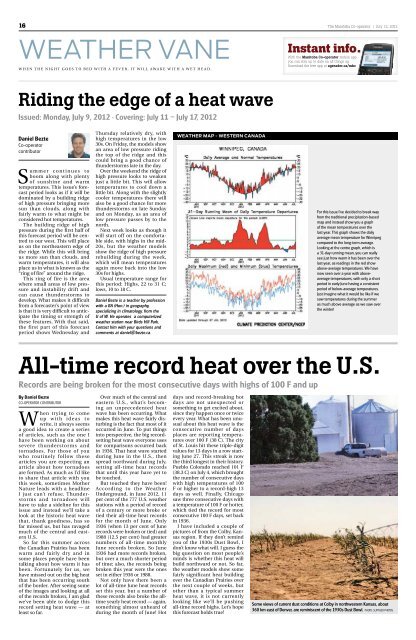
WEATHER MAP - WESTERN CANADA<br />
days and record-breaking hot<br />
days are not unexpected or<br />
something to get excited about,<br />
since they happen once or twice<br />
every year. What has been unusual<br />
about this heat wave is the<br />
consecutive number of days<br />
places are reporting temperatures<br />
over 100 F (38 C). The city<br />
of St. Louis hit these triple-digit<br />
values for 13 days in a row starting<br />
June 27. This streak is now<br />
the third longest in their history.<br />
Pueblo Colorado reached 101 F<br />
(38.3 C) on July 4, which brought<br />
the number of consecutive days<br />
with high temperatures of 100<br />
F or higher to a record-high 13<br />
days as well. Finally, Chicago<br />
saw three consecutive days with<br />
a temperature of 100 F or hotter,<br />
which tied the record for most<br />
consecutive 100 F days, set back<br />
in 1936.<br />
I have included a couple of<br />
pictures of from the Colby, Kansas<br />
region. If they don’t remind<br />
you of the 1930s Dust Bowl, I<br />
don’t know what will. I guess the<br />
big question on most people’s<br />
minds is whether this heat will<br />
build northward or not. So far,<br />
the weather models show some<br />
fairly significant heat building<br />
over the Canadian Prairies over<br />
the next couple of weeks, but<br />
other than a typical summer<br />
heat wave, it is not currently<br />
looking like we’ll be pushing<br />
all-time record highs. Let’s hope<br />
this forecast holds true!<br />
Instant info.<br />
With the Manitoba Co-operator mobile app<br />
you can stay up to date on all things ag.<br />
Download the free app at agreader.ca/mbc<br />
For this issue I’ve decided to break way<br />
from the traditional precipitation-based<br />
map and instead show you a graph<br />
of the mean temperatures over the<br />
last year. This graph shows the daily<br />
average mean temperature for Winnipeg<br />
compared to the long-term average.<br />
Looking at the centre graph, which is<br />
a 31-day running mean, you can really<br />
see just how warm it has been over the<br />
last year, as readings in the red show<br />
above-average temperatures. We have<br />
now seen over a year with aboveaverage<br />
temperatures, with only a short<br />
period in early June having a consistent<br />
period of below-average temperatures.<br />
Just imagine what it would be like if we<br />
saw temperatures during the summer<br />
as much above average as we saw over<br />
the winter!<br />
All-time record heat over the U.S.<br />
Records are being broken for the most consecutive days with highs of 100 F and up<br />
Some views of current dust conditions at Colby in northwestern Kansas, about<br />
360 km east of Denver, are reminiscent of the 1930s Dust Bowl. PHOTO: SUPPLIED PHOTOS