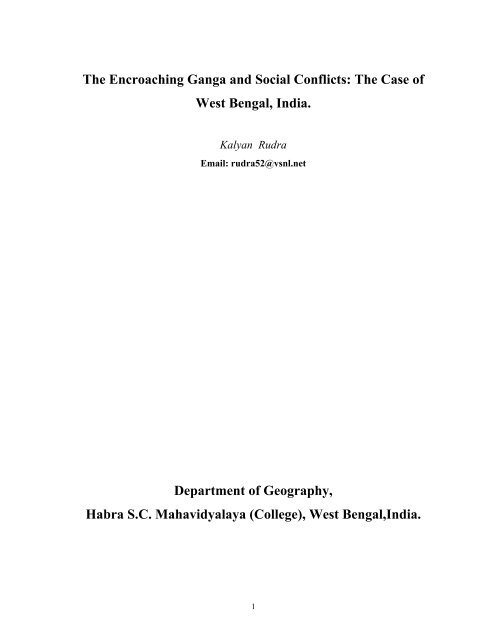
The Encroaching Ganga and Social Conflicts: The ... - GANGAPEDIA
The Encroaching Ganga and Social Conflicts: The ... - GANGAPEDIA
The Encroaching Ganga and Social Conflicts: The ... - GANGAPEDIA

You also want an ePaper? Increase the reach of your titles
YUMPU automatically turns print PDFs into web optimized ePapers that Google loves.
<strong>The</strong> <strong>Encroaching</strong> <strong>Ganga</strong> <strong>and</strong> <strong>Social</strong> <strong>Conflicts</strong>: <strong>The</strong> Case of<br />
West Bengal, India.<br />
Kalyan Rudra<br />
Email: rudra52@vsnl.net<br />
Department of Geography,<br />
Habra S.C. Mahavidyalaya (College), West Bengal,India.<br />
1
<strong>The</strong> <strong>Encroaching</strong> <strong>Ganga</strong> <strong>and</strong> <strong>Social</strong> <strong>Conflicts</strong>: <strong>The</strong> Case of<br />
West Bengal, India.<br />
Kalyan Rudra<br />
ABSTRACT<br />
<strong>The</strong> course of the <strong>Ganga</strong> upstream <strong>and</strong> downstream of the Farakka barrage continues to change unabated.<br />
This has resulted in many problems like l<strong>and</strong> reallocation causing border dispute between Jharkh<strong>and</strong> <strong>and</strong><br />
West Bengal <strong>and</strong> created a class of neo-refugees. <strong>The</strong> Government of West Bengal apprehends that the<br />
gnawing river may outflank the barrage in near future making project redundant. While millions of rupees<br />
are wasted every year in bank protection, the programme of rehabilitating the erosion-victims was not<br />
taken into account. <strong>The</strong> l<strong>and</strong> eroded from left bank of <strong>Ganga</strong> in Malda is more than 200 sq.km. ; While<br />
that from Murshidabad is about 356 sq,km. Since the flow of river intercepted at farakka, the sedimentation<br />
on the riverbed has increased. <strong>The</strong> barrage authority has so far denied the progrmme of silt management.<br />
<strong>The</strong> huge load of boulders utilised in anti-erosion works are dislodged every year <strong>and</strong> deposited on the<br />
riverbed. <strong>The</strong> basic objective of the Farakka Barrage has been frustrated as the problem of siltation in the<br />
Hugli estuary remains unsolved <strong>and</strong> port of Kolkata is not yet accessible to the large sea-going vessels.<br />
Though it is admitted in the official documents that the intensity of erosion in Malda <strong>and</strong> Murshidabad has<br />
increased after the construction of Farakka Barrage, the question of rehabilitation of the erosion-victims<br />
has not been given any heed.<br />
Prelude:<br />
<strong>The</strong> water resource engineering in India during the post-independent era was largely dedicated towards the<br />
expansion of irrigation to ensure the food security for the growing population. <strong>The</strong> irrigation was the<br />
prime objective of 96% of 4291 dams built in India (WCD, 2000). <strong>The</strong> Farakka Barrage does not belong to<br />
this category <strong>and</strong> is unique in status even in the world. It was built with the pious intension of inducing<br />
water into the Hugli river with a view to flush the sediment load into the deeper part of estuary <strong>and</strong><br />
resuscitate the navigational status of the Kolkata port. No other river-valley project of the world is<br />
2
comparable to the Farakka Barrage Project in respect of its objective that was based on arithmetic<br />
hydrology without any regard to multi-dimensional fluvial dynamics of the river. <strong>The</strong> sediment movement<br />
in tidal estuary of the Hugli is the function of a complex fluvial system that can hardly be governed by<br />
inducing 40000cusec(1132 cumec) of water. Our conservative estimate based on the Tide Tables for 2004<br />
published by Kolkata Port Trust reveals that during the high tide in May total amount of water induced<br />
into the estuary varies from 2559-6790×10 6 m 3 with the sediment load ranging from 2.60-6.80×10 6 ton. A<br />
similar estimate during August-September shows those to be1857-6813×10 6 m 3 <strong>and</strong> 1.86-6.81×10 6 ton<br />
respectively. <strong>The</strong> south flowing peak discharge in the Hugli even during monsoon hardly exceeds 4246<br />
cumec only. This poses most serious constraints for silt management in the estuary.<br />
While constructing barrage across <strong>Ganga</strong> at Farakka <strong>and</strong> even during the last three decades of its<br />
operation, the silt-management in the Farakka pond was given scant or no attention. It was largely the silt<br />
that has been trapped upstream of the barrage <strong>and</strong> that caused the disastrous consequences. <strong>The</strong> river bed<br />
upstream of the barrage is now so clogged with sediment that even a country boat can not negotiate freely<br />
during lean months. <strong>The</strong> river has been gnawing its left bank to open a new outlet outflanking the Farakka<br />
Barrage. <strong>The</strong> Geo-political scenario of the subcontinent has so changed since 1971 that operation of<br />
Farakka Barrage does not find a smooth passage. Since the introduction of high yielding technology <strong>and</strong><br />
expansion of irrigation in the upper <strong>and</strong> middle <strong>Ganga</strong> plain, the available water at Farakka during lean<br />
months dwindles far below the threshold limit <strong>and</strong> thereby exerts stress on the Indo-Bangladesh<br />
relationship. Nor the recommended discharge of 1132 cumec is induced for the port of Kolkata that<br />
continues to face the problem of navigational hazards. <strong>The</strong> annual discharge hydrograph of Bhagirathi at<br />
Jangipur below the outfall of feeder canal for the year 2000 was extremely skewed as tributaries like<br />
Bansloi,Pagla, Madhabjani,Kanloi contributed huge discharge because of a cloud burst in late September<br />
over upl<strong>and</strong>s of Santal Parganas in Jharkh<strong>and</strong>. <strong>The</strong> lean season induced discharge in the river was below<br />
the threshold limit fixed for the maintenance of the navigability of the port of Kolkata. <strong>The</strong> fluvial<br />
dynamics in the Hugli river is so complex that the concept of flushing the sediment seems to be a myth.<br />
One should also keep in mind that Farakka Barrage Project was designed on the data base of late 1950.<br />
But the catchment area of the <strong>Ganga</strong> has been drastically modified during last five decades <strong>and</strong> the present<br />
situation dem<strong>and</strong>s the review of the project afresh.<br />
3
Discharge in Cumec<br />
3500<br />
3000<br />
2500<br />
2000<br />
1500<br />
1000<br />
500<br />
0<br />
<strong>The</strong> Hydrograph of Bhagirathi at Jangipur (2000)<br />
Jan Feb Mar Apr May Jun Jul Aug Sep Oct Nov Dec<br />
Month<br />
Fig.1: Source: KPT, 2000<br />
4<br />
Avg.<br />
Max.<br />
Min.<br />
Kolkata Port: A colonial legacy:<br />
<strong>The</strong> European Merchants first visited Bengal during early 16 th Century. Satgaon was then the most<br />
important trading centre located on the eastern bank of Saraswati, a distributary of the Hugli river. But it<br />
was extremely difficult to approach the port from the sea because of the decaying status of Saraswati. <strong>The</strong><br />
large ships had to anchor at Batore <strong>and</strong> only Bazras could reach Satgaon during high tide (Mukherjee,<br />
1938).<br />
<strong>The</strong> Port of Kolkata emerged during late 18 th .century under colonial rule, though the wooden ships had<br />
been plying through this river during preceding centuries (Ghosh, 1972).Earlier in 1651, East India<br />
Company selected Hugli as the site for their trading operation ( Nair,1995). Hugli maintained its<br />
importance till the end of 17 th . century. In 1686, English came in a conflict with Mughals <strong>and</strong> started to<br />
look for a better <strong>and</strong> secured anchorage. In 1690 Job Charnock returned to Kolkata as he was granted<br />
permission by Emperor Aurangjeb for trading operation. <strong>The</strong> British rulers after taking over the total
administrative control over this part of the subcontinent, the hinterl<strong>and</strong> of the port of Kolkata extended far<br />
from Assam to Uttarpradesh. But the sailing had always been an arduous task in 200km. stretch from<br />
S<strong>and</strong>head to Kolkata because of the presence of many under-water shoals <strong>and</strong> sinuous thalweg of the river<br />
(Ray, 1990). <strong>The</strong> 20 th . Century witnessed a revolution in the ship building technology <strong>and</strong> ships of larger<br />
size <strong>and</strong> greater draught started to dominate the maritime trade. A sea-going ship requiring draft of more<br />
than eight metres could hardly approach the an inl<strong>and</strong> riverine port like Kolkata . It is only during high tide<br />
a ship ventures to sail up the Hugli estuary <strong>and</strong> that too is not a smooth ride.<br />
<strong>The</strong> diminishing headwater supply <strong>and</strong> increasing sediment load posed serious challenge for navigation.<br />
<strong>The</strong> catchment areas of the western tributaries to the Bhagirathi have been drastically modified during last<br />
two centuries. <strong>The</strong> hydraulic regime of this area was largely modified due to expansion of agriculture,<br />
indiscriminate exploitation of ground water, depletion of forest cover, expansion of road <strong>and</strong> railways <strong>and</strong><br />
building of dams <strong>and</strong> barrages across the rivers. All these events were combined to contribute increasing<br />
sediment load <strong>and</strong> diminishing water in the Bhagirathi-Hugli river. Since the dams had been built across<br />
some of the western tributaries, the peak discharge of the Bhagirathi has been reduced. This in turn<br />
affected the ability to flush the sediment load into the sea. <strong>The</strong> Port Authority of Kolkata started to dredge<br />
the navigation channel since 1820 <strong>and</strong> continues to do so even today. But such palliative measure does not<br />
reverse the decay of river.<br />
A Project to Resuscitate the Dying Bhagirathi Channel <strong>and</strong> Navigability of the Port:<br />
<strong>The</strong> difficult <strong>and</strong> dangerous state of navigation in the Hugli estuary was a matter of deep anxiety of the<br />
British, as the navigation was intimately related to colonial exploitation. In fact, decay of the Bhagirathi-<br />
Hugli river started long before the establishment of Kolkata port. <strong>The</strong> earliest description of the decay of<br />
Bhagirathi dates back 6, January, 1666. Tavernier, the French traveller wrote- “Bernier was going over<br />
l<strong>and</strong> from Rajmahal to Cossimbazar as the river route was impracticable…when the river is low it is<br />
impassable because of large s<strong>and</strong> bank which lies before the town called Suti”.(Rudra,1992). About a<br />
century after Bernier, Rennell(1788) witnessed -“Cossimbazar river is almost dry October to May”. <strong>The</strong><br />
Off-take was so closed with s<strong>and</strong> deposit that cargoes sailing down <strong>Ganga</strong> had to anchor at Suti in<br />
Murshidabad <strong>and</strong> goods were carried down to Jangipur on l<strong>and</strong> <strong>and</strong> thence transported down the<br />
Bhagirathi on small boats. Since the closure of the Bhagirathi off-take, Jalangi <strong>and</strong> Mathabhanga-Churni<br />
were used as alternative routes of navigation. Captain Brame noted-“ Jalangi was used for main line of<br />
steamers from Calcutta to Goalundo or Assam during rains from 1858 to 1866. But subsequently it<br />
5
deteriorated <strong>and</strong> Mathabhanga was used for navigation in 1882. It was quite good up to 1884 <strong>and</strong><br />
afterwards gradually deteriorated; while Jalangi improved <strong>and</strong> by 1890 it became so bad that we<br />
ab<strong>and</strong>oned it in favour of Jalangi <strong>and</strong> it was never used since. We used Jalangi for main line of steamers<br />
(towards Goalundo, Assam) upto1896. We continued to use Jalangi for small craft up to 1907 from which<br />
date forward we ceased to use the river altogether”(Rudra,2000a). In 1853, Bengal Chamber of<br />
Commerce proposed the establishment of a substitute port on the bank of Matla river, some 40km. to the<br />
south of Kolkata. <strong>The</strong> Port was named after Lord Canning. <strong>The</strong> newly built port decayed within a decade<br />
<strong>and</strong> was officially closed in 1871 (GoI 1865). It was then obligatory for the British Imperial Power to<br />
explore the ways <strong>and</strong> means to resuscitate the navigational status of Kolkata port. <strong>The</strong> engineers first tried<br />
to cut open the off-take point of the Bhagirathi to induce water from the <strong>Ganga</strong>. But such attempts were<br />
proved futile as the water-level of <strong>Ganga</strong> fell five metres below the bed-level of Bhagirathi during lean<br />
months. <strong>The</strong> off-take ceaselessly migrated from one point to other between 1781-1925 (Mitra,1953) <strong>and</strong><br />
the process continued till 1975 when a barrage across the Bhagirathi was constructed <strong>and</strong> thereby closed<br />
its link with the Padma.<br />
<strong>The</strong> construction of barrage across the <strong>Ganga</strong> <strong>and</strong> diversion of water towards the Bhagirathi was first<br />
suggested by Sir Arthur Cotton as far back as in 1853. Many other British Engineers supported this view<br />
though they were not unanimous about the site of the barrage. <strong>The</strong> proposal to resuscitate the port of<br />
Kolkata was shelved till the independence when the National Government paid heed on the proposal. In<br />
1957, Government of India invited Dr. W. Hensen to explore the causes of decay of the Hugli river <strong>and</strong> to<br />
suggest remedial measures. After careful investigation, he suggested that “<strong>The</strong> best <strong>and</strong> only technical<br />
solution of the problem is the construction of a barrage across <strong>Ganga</strong> at Farakka with which the upl<strong>and</strong><br />
discharge into the Bhagirathi-Hooghly can be regulated as planned, <strong>and</strong> with which the long term<br />
deterioration in the Bhagirthi-Hooghly can be stopped <strong>and</strong> possibly converted into a gradual<br />
improvement. With a controlled upl<strong>and</strong> discharge a prolongation of freshet period will be obtained, <strong>and</strong><br />
the sudden freshet peaks which will cause heavy s<strong>and</strong> movement <strong>and</strong> bank erosion will be flattened”<br />
(GoI,1975). <strong>The</strong> hypothesis arithmetic hydrology of the Farakka Barrage Project was subsequently proved<br />
untenable. In a tidal estuary like Hugli where ratio of volume of water carried by a north flowing tide <strong>and</strong><br />
that by southward flowing monsoon freshet may be disproportionate to the order of 78:1 <strong>and</strong> thus the idea<br />
of flushing the sediment load down to deeper estuary was too optimistic. In view of massive volume of<br />
tidal water, the induced water is too meagre to bring any positive impact.<br />
6
<strong>The</strong> construction of Farakka barrage was started in 1962 <strong>and</strong> was completed in 1971. <strong>The</strong> excavation of<br />
the 38km.long feeder canal took about four years <strong>and</strong> the project was commissioned on the<br />
Feeder<br />
Canal<br />
Farakka Barrage<br />
<strong>Ganga</strong><br />
Bhagirathi<br />
Image-1: Layout of the Farakka Barrage Project.<br />
21 st .May, 1975. During the construction of this mighty barrage, there was a transformation in the political<br />
scenario of this subcontinent. Bangladesh emerged as a sovereign country from erstwhile East Pakistan<br />
<strong>and</strong> this rendered a new dimension to the dispute over the sharing of <strong>Ganga</strong> water. <strong>The</strong>re was also largescale<br />
expansion of irrigation in the upper <strong>Ganga</strong> basin since introduction high yielding techniques in<br />
agriculture. In absence of any national policy relating to interstate sharing of water, the upper riparian state<br />
started to abstract water from <strong>Ganga</strong> indiscriminately. This caused diminution of water in the lower reach<br />
leading to many social stresses. However, Let us have a glance at the technical detail <strong>and</strong> layout of the<br />
Farakka Barrage Project.<br />
7<br />
Mahan<strong>and</strong>a<br />
Jangipur<br />
Barrage<br />
Fazilpur
A. Farakka Barrage:<br />
SALIET FEATURES OF THE FARAKKA BARRAGE PROJECT<br />
Length: 2.62Km.<br />
Number of Bays: 109<br />
Span of Each Bay: 18.30m.<br />
Lowest Bed Level: 10.30 m above m.s.l.<br />
Pond Level: 21.90 m above m.s.l.<br />
Crest Level of Spillway: 15.80 m above m.s.l.<br />
Crest Level of Under Sluices <strong>and</strong> River Sluices: 14.30 m above m.s.l.<br />
B. Head Regulator<br />
Pond Level: 21.90 m above m.s.l.<br />
Full Supply Level at L<strong>and</strong>: 1133 cumec.<br />
Clear Water Way: 11 bays of 12.20m.each.<br />
Crest Level: 18.10 m above m.s.l.<br />
C. Feeder Canal:<br />
Length: 38.30 km.<br />
Design Discharge: 1133 cumec.<br />
Bed Width: 150.80m.<br />
Full Supply Depth: 6.10m<br />
D. Jangipur Barrage:<br />
Length: 212.70m.<br />
Number of Bays: 15<br />
Span of Each Bay: 12.2m.<br />
Crest Level: 12.80m. above m.s.l.<br />
Source: Basu(1982)<br />
Myth <strong>and</strong> Reality:<br />
<strong>The</strong> fluvial processes operating the in the Hugli estuary is extremely complex. In this funnel shaped <strong>and</strong><br />
north-south aligned estuary, the tide dominates over the diminishing headwater supply even during the<br />
peak of monsoon. <strong>The</strong> Hugli estuary is unique in nature compared to many other outlets of the <strong>Ganga</strong>. It is<br />
the only river that reaches the sea in a southerly direction while all others flow in a south-easterly<br />
direction. <strong>The</strong> Bhagirathi-Hugli river has a catchment area an covering about 55617 sq.km.<strong>and</strong> that is<br />
drained by seven major tributaries namely, Pagla, Bansloi, Mayurakshi, Ajoy, Damodar, Rupnarayan<br />
8
,Haldi <strong>and</strong> the two offshoots of <strong>Ganga</strong> – Jalangi <strong>and</strong> Churni. <strong>The</strong> lower 281 km. of river is tidal while the<br />
upper 221 km. remains perennial during lean months mainly by the induced water of the <strong>Ganga</strong>-<br />
Bhagirathi feeder canal.<br />
<strong>The</strong> induced water through <strong>Ganga</strong>-Bhagirathi feeder canal was supposed to flush the sediment load from<br />
the estuary <strong>and</strong> keep the navigation channel free from siltation. But the objective was proved a myth as<br />
sedimentation in the estuary continues unabated. It is admitted in the published document of the Kolkata<br />
Port Trust that induced discharge from Farakka Barrage has had not been able to negate the estuarine<br />
sedimentation. <strong>The</strong> annual quantum of dredging has increased from 6.40m.m 3 during pre-farakka days to<br />
13.24m.m 3 during post-farakka days. (Sanyal <strong>and</strong> Chakraborty, 1995) This has further been increased to<br />
21.18m.m 3 per annum during 1999-2003.<br />
25<br />
20<br />
15<br />
10<br />
5<br />
0<br />
ANNUAL QUANTUM OF DREDGING<br />
( in million cu.m.)<br />
Pre-Farakka- Post-Farakka Recent<br />
Fig.2: Pre-Farakka- till 1975; Post-Farakka-1976-1994; Recent-1999-2003.<br />
<strong>The</strong>re are various sources contributing sediment load into the Bhagirathi-Hugli river. <strong>The</strong> Feeder Canal<br />
was supposed to induce relatively silt-free water from Farakka Pond through its three tier head regulator.<br />
<strong>The</strong> annual sediment loads at Jangipur <strong>and</strong> Berhampur are estimated to be 7.09 <strong>and</strong> 15.60 million tons<br />
respectively. <strong>The</strong> Kolkata Port Trust has estimated the sediment load being transported down Nabadwip as<br />
25.66×10 6 t/yr. It is important to note that out of the 10.06× 10 6 t/yr being added between Berhampur <strong>and</strong><br />
Nabadwip, Ajoy <strong>and</strong> Mayurakshi contribute about 3.91 × 10 6 t/yr. <strong>The</strong> Jalangi <strong>and</strong> Churni pour in 3.71 ×<br />
10 6 t/yr between Mayapur <strong>and</strong> Kalinarayanpur. Though Damodar, Rupnarayan, Haldi <strong>and</strong> Rasulpur creek<br />
add 11.22 × 10 6 t/yr between Uluberia <strong>and</strong> Haldia, the annual sediment load transported below Diamond<br />
Harbour is 23.68 × 10 6 t/yr <strong>and</strong> that is 1.98 × 10 6 t. less than the load observed at Nabadwip. This proves<br />
9
eyond doubt that about 13.20 × 10 6 t/yr. is either being deposited or remains in circulation every year<br />
between Nabadwip <strong>and</strong> Diamond Harbour. <strong>The</strong> Kolkata Port Trust has estimated that a total load of about<br />
26.93 × 10 6 t/yr remains in circulation annually between Diamond Harbour <strong>and</strong> Sagar <strong>and</strong> that creates<br />
impediment to navigation. <strong>The</strong> sediment movement in the estuary is tide dominated <strong>and</strong> that can push back<br />
4.90 to 14.67 × 10 6 tons of sediment each time. It is difficult to estimate how much of this load is left<br />
behind by the ebb flow.(see sediment flow model). One major reason of increasing sediment load in the<br />
river is the depletion of forest cover, expansion of agriculture in the catchment areas <strong>and</strong> increasing bank<br />
failure in Murshidabad in Nadia districts. Since the construction of a series of dams across the western<br />
tributaries, the peak discharge in the Bhagirathi has been reduced <strong>and</strong> thereby the ability to flush the<br />
sediment towards the deeper sea has declined. No less than fifteen under-water shoals create barriers<br />
across the navigation route approaching the port of kolkata.<br />
. <strong>The</strong> differential velocity of the high <strong>and</strong> low tide is one of the major causes of<br />
decay of the river. In this north-south aligned estuary, on rushing tide flows at a faster velocity (~ 9<br />
km/hour) <strong>and</strong> deflected towards eastern bank due to coriolis force. <strong>The</strong> water-level may fluctuate from<br />
0.96 m to 5.71 m during August-September at Sagar <strong>and</strong> that at Diamond Harbour is observed to be<br />
between 0.90 – 6.45 m within around six hours(GoI,2004). <strong>The</strong> ebb tide flows back along the western<br />
bank at a slower velocity (~ 6 km/hour) during next eight hours. This fluvial dynamics leaves behind a<br />
substantial part of the sediment that entered into the estuary with high tide. Major Hirst (1915)<br />
apprehended that the “forces controlling it are so powerful that any artificial interference would be<br />
futile”. <strong>The</strong> experience of Kolkata Port Trust corroborates this view <strong>and</strong> as such the port has tendency to<br />
migrate southward from Kolkata-Haldia-Kalpi to Sagar.<br />
<strong>The</strong> Farakka Barrage: intercepted flow <strong>and</strong> trapped sediment:<br />
<strong>The</strong> 2.64 km long Farakka Barrage was designed to divert 40,000 cusecs (1133 cumec) of <strong>Ganga</strong> water<br />
towards Bhagirathi so that the navigational status of the Calcutta Port could be resuscitated. This mighty<br />
intervention into the river impaired its dynamic equilibrium in many ways. Mr P.K.Parua (2002), former<br />
Superintendent Engineer of the Farakka Barrage Project, has noted that “the construction of the barrage<br />
has disturbed this apparent equilibrium condition <strong>and</strong> the river started to adjust this huge human<br />
interference by aggradation <strong>and</strong> degradation of its bed <strong>and</strong> channel pattern by erosion <strong>and</strong> siltation. <strong>The</strong><br />
processes will continue for a quite long time in such a mighty river till a new dynamic equilibrium is<br />
established. In the post-barrage condition, the normal sediment transport system has been intercepted due<br />
10
to controlled operation of the barrage gates <strong>and</strong> river bed on upstream started aggrading with the change<br />
of erosion / deposition pattern of river bed <strong>and</strong> banks. <strong>The</strong> new s<strong>and</strong> isl<strong>and</strong>s have come up gradually with<br />
general rise in river bed level <strong>and</strong> formation of deep narrow thalweg on left side. <strong>The</strong> normal flood level<br />
has increased with reduction in channel capacity. This has increased the flood intensity on upstream at<br />
lesser discharge in post barrage situation which could be noticed in Malda district in during last two<br />
decades”. <strong>The</strong> Irrigatin <strong>and</strong> Waterways Directorate, Government of west Bengal, was firm to opine that<br />
construction of Farakka Barrage <strong>and</strong> the menace of erosion in Malda are intimately related (Ray,2000).<br />
<strong>The</strong> 13 th . Legislative Aseembly Committee. (2004) in its 7 th . Report noted “ It is accepted all levels that<br />
the construction of Farakka Barrage is solely responsible behind the erosion of river Ganges in Malda<br />
district ”.<br />
Since the pond level at Farakka was elevated from 15.24m to 21.95 m. by impounding 87mm 3 of water,<br />
the hydraulic gradient of the <strong>Ganga</strong> above the barrage was flattened, leading to increasing tendency of<br />
flood <strong>and</strong> erosion. <strong>The</strong> one major impact of impounding of water has been sedimentation <strong>and</strong> resultant<br />
reduction of the cross-sectional area of the river. <strong>The</strong> <strong>Ganga</strong>-Brahmaputra system contributes largest<br />
amount of sediment among all rivers <strong>and</strong> that was estimated to be 1667 × 10 6 t/yr(Milliman <strong>and</strong><br />
Meade,1983). <strong>The</strong>re are differences of opinion among the experts about the annual sediment load carried<br />
by <strong>Ganga</strong> at Farakka. Abbas <strong>and</strong> Subramanium(1984) measured it as 801 × 10 6 t/yr. Wasson (2003) has<br />
put forward a lesser figure <strong>and</strong> that is 729 × 10 6 t/yr <strong>The</strong> estimation of this author puts the figure to 736 ×<br />
10 6 t/yr. <strong>The</strong> State Irrigation Department came forward with a surprisingly low estimate of 301 × 10 6 t/yr<br />
(Ray, 1999). Many dams <strong>and</strong> barrages constructed across the tributaries of <strong>Ganga</strong> intercept the sediment<br />
flow <strong>and</strong> thereby reduce the available load at Farakka. Wasson wrongly conceived that out of 729× 10 6<br />
t/yr that passes Farakka, 328 × 10 6 t/yr is lost down the Hugli river leaving an estimated 401 × 10 6 t/yr<br />
pass to Bangladesh down the Padma compared with 440 × 10 6 t/yr measured in Bangladesh. But the three<br />
tier head regulator at the off-take point of the feeder canal hardly allows more than 6.76 × 10 6 t/yr pass to<br />
Jangipur <strong>and</strong> remaining 328.24 × 10 6 t/yr is being trapped in the Farakka pond. In addition to this trapped<br />
sediment load, tons of boulders which are used for anti-erosion works along the banks, are too often<br />
dislodged <strong>and</strong> deposited into the river. <strong>The</strong> construction of a 100-m long spur requires 14357 tons of<br />
boulders. Out of 27 spurs constructed so far upstream of the Farakka Barrage, 20 spurs have been fully or<br />
partially swept away. <strong>The</strong> Spur Nos. 18, 20 <strong>and</strong> 24 which were recently re-constructed have also been<br />
out-flanked. <strong>The</strong> river borne sediments, boulders <strong>and</strong> ruins of the eroded village are combined in the<br />
11
iverbed <strong>and</strong> create formidable obstruction to the flow of the river. <strong>The</strong> current is thus deflected towards<br />
the causing erosion thereon.<br />
<strong>The</strong> reduction of the cross-sectional area <strong>and</strong> gradual me<strong>and</strong>er formation between Rajmahal hills <strong>and</strong><br />
Farakka has altered the direction of flow which is no longer co-axial to the barrage. <strong>The</strong> flow has rather<br />
become oblique <strong>and</strong> concentrates more towards the right side of the barrage. This causes swelling of<br />
water during the peak of the monsoon. One bay of the barrage cannot discharge more than 30,000 cusecs<br />
(840 cumec) of water, but because of the obliquity of the flow, additional 40% water is often concentrated<br />
along the right h<strong>and</strong> side bays. It is striking to note that the peak discharge at Farakka in the year 1981<br />
was57000 cumec <strong>and</strong> maximum pond level was observed to be 23.70m. But in the year 2003 the peak<br />
discharge (57520 cumec) was slightly higher than that of 1981 but the pond-level was elevated to 24.78m.<br />
This is a clear indication of the induced sedimentation <strong>and</strong> reduction of the cross-sectional area of the<br />
river.<br />
Table-1: Peak Discharge <strong>and</strong> Pond-Level at Farakka<br />
Year Approx. max. discharge Approx. max. Increase in height (m)<br />
(10³ cumec)<br />
water level (m) (Original pond level: 21.95 m)<br />
1979 42.80 22.90 0.95<br />
1981 57.0 23.70 1.75<br />
1983 60.5 24.90 2.95<br />
1985 57.30 24.30 2.35<br />
1988 68.0 25.10 3.15<br />
1991 69.70 25.30 3.35<br />
1993 54.20 24.10 2.15<br />
1996 71.0 25.10 3.15<br />
1998 75.90 25.40 3.45<br />
2001 45.68 24.00 2.05<br />
2003 57.52 24.78 2.83<br />
Source: Compiled from Parua(1999 <strong>and</strong> 2003); Rudra(2003);B<strong>and</strong>yopadhya & Mallik, 2004.<br />
12
Max Discharge (Cumec)<br />
80<br />
70<br />
60<br />
50<br />
40<br />
30<br />
20<br />
10<br />
0<br />
Fig.-3: Peak Discharge <strong>and</strong> Pond-Level at Farakka<br />
1979 1981 1983 1985 1988 1991<br />
Year<br />
1993 1996 1998 2001 2003<br />
13<br />
26<br />
25.5<br />
25<br />
24.5<br />
24<br />
23.5<br />
23<br />
22.5<br />
22<br />
21.5<br />
Max Pond Level (m)<br />
Approx. max.<br />
discharge (10³<br />
cumecs)<br />
Approx. max.<br />
water level (m)<br />
<strong>The</strong> outliers of Rajmahal hills along the right bank aggravated the situation. It is the geological node where<br />
the river strikes <strong>and</strong> the deflected flow impinges opposite bank with immense force. <strong>The</strong> tendency of<br />
eastward migration of the river was observed long before the construction of the Farakka Barrage but the<br />
situation deteriorated further when the construction of the barrage started with partial blockade of the river<br />
by coffer dams in early 1960s. <strong>The</strong> river has now formed a mighty bend between two nodal points - the<br />
Rajmahal <strong>and</strong> Farakka. While the former is a geological node, the latter is an artificial node. Any<br />
artificial structure across the river, be it a dam or barrage, accelerate the problem of sedimentation on the<br />
river bed. <strong>The</strong> Farakka barrage is no exception.
INFLOW<br />
736<br />
Feeder Canal<br />
6.76<br />
Pagla-<br />
Bansloi 0.33<br />
Mayurakshi 2.52<br />
Ajoy 1.39<br />
Nabadwip 25.66<br />
(Tidal Limit)<br />
Damodar 4.94<br />
Fig.4: Annual Sediment Flow in Lower <strong>Ganga</strong> System.<br />
(in million tons)<br />
Trapped in Farakka<br />
Pond 328.24<br />
Jangipur 7.09<br />
Berhampur 15.60<br />
Rupnarayan 3.63<br />
Jalangi-Churni<br />
Systeem 3.71<br />
Haldi 2.43<br />
Rasulpur 0.22<br />
14<br />
Diamond Harbour<br />
23.68<br />
BANGLADESH 401<br />
Tidal intrusion<br />
1.86-6.81<br />
Sediment load in<br />
circulation between<br />
Diamond Harbour<br />
<strong>and</strong> <strong>Ganga</strong>sagar<br />
26.93
Geomorphic Processes of Bank Failure<br />
<strong>The</strong> deltaic rivers have the tendency to oscillate with wide limit. <strong>The</strong> swatch of me<strong>and</strong>er sweep is<br />
proportional to the discharge flowing through of the river. <strong>The</strong> principal river also throws off distributaries<br />
to facilitate delta-building operation. <strong>The</strong> distributaries may be alternately rejuvenated <strong>and</strong> decayed with<br />
the passage of time. In an uncontrolled situation, the rivers enjoy the opportunity of free swing. But in this<br />
densely populated part of the World, the human intervention exerts immense influence on the river system<br />
<strong>and</strong> interrupts its natural behaviour. <strong>The</strong> <strong>Ganga</strong> system in West Bengal has some unique characteristics in<br />
respect of its fluctuating discharge, sediment load, tidal intrusion in the lower reach, role of western<br />
tributaries, diminishing slope of the thalweg, reversible hydraulic gradient with high <strong>and</strong> low tide <strong>and</strong> neotectonic<br />
of the delta. <strong>The</strong> various river training works exert large influence on the fluvial dynamics of the<br />
delta. Apart from the 2.64 km. long Farakka barrage which was built across the river during 1962-1971,<br />
the flood-control embankments, bank revetment with boulders, construction of the spurs to deflect the<br />
impinging current, enormous exploitation of the ground water causing substantial reduction of the effluent<br />
seepage into the river- are all combined to interrupt the fluvial dynamic of the delta. <strong>The</strong> encroaching<br />
<strong>Ganga</strong> during the monsoon causes damage to human settlement. This is particularly conspicuous in the<br />
upstream of the Farakka barrage in Malda district. <strong>The</strong> problem of erosion <strong>and</strong> population displacement is<br />
of no less magnitude in the down stream section of the Farakka barrage in Murshidabad. (Rudra, 1996).<br />
15
Plate-1: Bank stratigraphy exposed near Panchan<strong>and</strong>apur,Malda.<br />
Plate-2: Shelving Bank at Nirmalchar where thin clay-layer<br />
overlays unconsolidated micaceous s<strong>and</strong>-layer.<br />
16<br />
Thin layer silt-clay<br />
<strong>The</strong><br />
unconsolidated<br />
layer of s<strong>and</strong> that<br />
makes the bank<br />
vulnerable.
<strong>The</strong> erosion along the bank of the <strong>Ganga</strong> is the phenomenon of the monsoon months (June – September),<br />
<strong>and</strong> it has two distinct phases: the pre-flood <strong>and</strong> post-flood erosion. <strong>The</strong> fluctuation of discharge <strong>and</strong><br />
stratigraphy of the bank are two major factors contributing to the bank erosion. <strong>The</strong> peak discharge of the<br />
river may be to the tune of 75.90 ×10 3 cumec, as was observed in September 1998. <strong>The</strong> fast moving<br />
current during the rising stage of discharge removes unconsolidated sediment from the base of the<br />
shelving bank which ultimately collapses. <strong>The</strong> stratigraphy c of the bank, being composed of micaceous<br />
s<strong>and</strong> at the bottom <strong>and</strong> silt-clay upon it, appears to be responsible for this process. <strong>The</strong> post-flood erosion<br />
is related to the effluent flow of the ground water into the river. This occurs during the falling stage of the<br />
discharge. <strong>The</strong> flow of the ground water toward the river leads to liquefaction <strong>and</strong> flowage of basal<br />
sediments of the bank. However, in both cases a linear crack, often 100 metres in length, develops along<br />
the bank <strong>and</strong> the edge of the bank collapse into the river along this line.<br />
Plate-3: Linear cracks developed along the bank due to undercutting of<br />
basal s<strong>and</strong>-layer.<br />
<strong>The</strong>se types of erosion are common in any uncontrolled channel of the deltaic tract. But the case <strong>Ganga</strong> in<br />
West Bengal is quite different. <strong>The</strong> river in the stretch upstream of <strong>Ganga</strong> is so clogged with sediment that<br />
river is compelled to alter its course. <strong>The</strong> mighty river even threatens to outflank the Farakka Barrage <strong>and</strong><br />
17
open a new route through the presently moribund channels of Kalindri <strong>and</strong> Mahan<strong>and</strong>a. <strong>The</strong> eastward<br />
encroaching river while forming a mighty me<strong>and</strong>er bend in Malda has left behind four moribund channels<br />
which are now flowing sluggishly through the newly emerged char. <strong>The</strong> most prominent of these channels<br />
is identified as mid-channel in official records.<br />
Plate-4: <strong>The</strong> breached embankment near Panchan<strong>and</strong>apur. Here the<br />
encroaching river threatens to outflank the Farakka Barrage.<br />
18
Plate-5: <strong>The</strong> gnawing river engulfs all natural resources.<br />
Myth of Dredging:<br />
<strong>The</strong> engineers of Irrigation Department are of opinion that dredging of mid-channel <strong>and</strong> diverting the main<br />
flow towards opposite bank can be the best technical solution of preventing erosion in Malda. <strong>The</strong> experts<br />
of the Central Water <strong>and</strong> Power Research Station declined to corroborate such view in 2002. <strong>The</strong>y<br />
apprehended that the mid-channel would be naturally rejuvenated within next two seasons <strong>and</strong> would carry<br />
major share of the discharge thereby reducing the attack on left bank near Panchan<strong>and</strong>apur<br />
region(Vendre,2002). Two years have already elapsed but such apprehension proved futile.<br />
<strong>The</strong> most important question is whether it is possible to dredge the sediment that has hitherto been trapped<br />
upstream of Farakka since 1975.<strong>The</strong> first condition of such massive project is that the amount of spoil to<br />
be lifted must be twice the amount deposited in a year, if the project is to be completed within thirty years.<br />
Otherwise there would be no appreciable positive impact. Even a conservative estimate reveals that if a<br />
truck carries seven cubic meter of sediment, number of trucks required to dispose the lifted sediment load<br />
would be so many that their total length could encircle the equator 126 times. At least a fourteen-lane<br />
dedicated highway would be required to build between Malda <strong>and</strong> <strong>Ganga</strong>sagar to transport the sediment to<br />
the estuary. Only the transport cost may be twice the revenue that Government of India earns in a year.<br />
19
<strong>The</strong> most serious challenge of taming the river is to make the flow co-axial to the barrage. It was once<br />
thought that the diversion of more water towards the left-h<strong>and</strong> side of the barrage can be achieved by the<br />
regulation of the western gates. But such an attempt would result in the rise of the water level to the tune<br />
of 61cm. at Farakka <strong>and</strong> 23 cm. at Rajmahal (Singh et al, 1980 & Keshkar et al, 1996). It was further<br />
proposed by the experts that the excavation of an 18 km. long pilot channel might make the flow again coaxial<br />
to the barrage. <strong>The</strong> proposed pilot channel might be excavated along the ab<strong>and</strong>oned path of the<br />
<strong>Ganga</strong>, which is locally known as “Bohudubi Danra”. <strong>The</strong> State Irrigation Department apprehended<br />
in1999 that old channel would be rejuvenated (GoWB, 1999), but no such sign was observed by this<br />
author during the recent field visit. <strong>The</strong> design of Farakka Barrage is unique in nature having unilateral<br />
feeder canal towards the Bhagirathi. <strong>The</strong> extensive deposition <strong>and</strong> resultant formation of shoal along the<br />
left-h<strong>and</strong> side has further complicated the situation. <strong>The</strong> old railway line, which was laid before the<br />
construction of the barrage, is now masked by superficial sediment deposition. This seems to be another<br />
cause of deflection of the current towards the right h<strong>and</strong> side of the barrage.<br />
<strong>The</strong> Earlier Course of the <strong>Ganga</strong> in Malda:<br />
<strong>The</strong> <strong>Ganga</strong> enters the state of West Bengal dashing the Rajmahal hills of Jharkh<strong>and</strong> along the right bank<br />
<strong>and</strong> flows for about 72 km. before it approaches the Farakka Barrage. <strong>The</strong> river does not get the<br />
opportunity of free swing downstream of the Rajmahal hills as the outlier of hard rock along the right bank<br />
does not allow the river to encroach westward. In the second decade of the Twentieth Century, the course<br />
of the <strong>Ganga</strong> between Rajmahal <strong>and</strong> Farakka was straight <strong>and</strong> aligned in a south-easterly direction. This<br />
course is described in the topographical sheet bearing No.72 P/13 (1:63360), surveyed in the year 1922-23.<br />
This was not the course of the river during the earlier centuries when <strong>Ganga</strong> flowed along an altogether<br />
different course dashing Gour, the mediaeval capital town of Bengal.<br />
20
Rajmahal<br />
Bhutni<br />
<strong>The</strong> course of <strong>Ganga</strong><br />
(1922-23)<br />
Manikchak<br />
Image-2: <strong>The</strong> recent course of the <strong>Ganga</strong> in Malda<br />
Rennell (1788) wrote that, “Gour, the ancient capital of Bengal, stood on the old bank of Ganges: although<br />
its ruins are 4 or 5 miles from the present bank.” Prof.R.K.Mukherjee (1938), the eminent historian, noted<br />
in his book entitled “<strong>The</strong> Changing Face of Bengal”, that, “Leaving the hills of Rajmahal, Ganges seemed<br />
to have passed northwards through the modern Kalindri <strong>and</strong> then southwards in the lower course of<br />
Mahan<strong>and</strong>a, east of the ruins of ancient Gour”. Sir J.N.Sarkar (1973 reprint) in “<strong>The</strong> History of Bengal:<br />
Muslim Period 1200-1757” also corroborated the view expressed by Mukherjee. Sarkar noted that, “<br />
Time has levelled to the dust the glories of the Gauda under Hindu <strong>and</strong> Muslim rule <strong>and</strong> the ruins of their<br />
capital lies scatterred in heaps for miles along the eastern bank of Kalindri river through which flowed the<br />
21<br />
<strong>The</strong> course of <strong>Ganga</strong><br />
(1997)<br />
Panchan<strong>and</strong>apur<br />
<strong>The</strong> approximate<br />
position of bankline<br />
in 2005.
main current of the Ganges down to the close of the Thirteenth Century.” Major Hirst (1915) attributed<br />
the subsequent changes of the course of <strong>Ganga</strong> to the tectonic causes. He opined, “<strong>The</strong>re was a severe<br />
earthquake in 1505 A.D. <strong>and</strong> shortly after it, the Ganges left its old course past Gour <strong>and</strong> retreated<br />
southwards.” <strong>The</strong>re were two other distributaries of the <strong>Ganga</strong> namely Choto Bhagirathi <strong>and</strong> Pagla which<br />
joined each other near Mehdipur <strong>and</strong> flowed southeast to join Mahan<strong>and</strong>a. <strong>The</strong> latter subsequantly<br />
discharged into the Padma near Godagarhi Ghat of Rajshahi (Bangladesh). In the process of this<br />
migration, Kalindri, Choto Bhagirathi <strong>and</strong> Pagla were left moribund. <strong>The</strong> capital town of the Gour, which<br />
flourished to its peak in the 15 th <strong>and</strong> 16 th Century, was located on the interfluve between Kalindri <strong>and</strong><br />
Bhagirathi. <strong>The</strong> decay of these two distributaries might have been a slow process covering several<br />
centuries. <strong>The</strong>re are historical references of mediaeval riverine route between Chittagong <strong>and</strong> Gour (Ray<br />
1999). One cannot sail up the present river course of deltais Bengal from Chittagong to Gour. <strong>The</strong><br />
medieval navigation route must have been through Padma-Mahan<strong>and</strong>a-Kalindri or Choto Bhagirathi. <strong>The</strong><br />
bulk of the waters of the <strong>Ganga</strong> must have flown through this course, otherwise it could hardly facilitate<br />
navigation. <strong>The</strong> lower Mahan<strong>and</strong>a below old Malda must have been a part of the <strong>Ganga</strong>. <strong>The</strong> present<br />
course of the <strong>Ganga</strong> between Manikchak of Malda <strong>and</strong> Godaghari Ghat of Rajshahi was either nonexistent<br />
or insignificant. <strong>The</strong> decline of Gour after 1575 A.D. may be attributed to the changing course of<br />
the <strong>Ganga</strong> system. <strong>The</strong>se changes must have taken place much before Rennell pursued the survey during<br />
1764-1777 as his map depicts the course of <strong>Ganga</strong> flowing far south of the Gour. <strong>The</strong> researches on the<br />
river system of medieval Bengal suffers from non-availability of true <strong>and</strong> correct map as the first<br />
systematic survey <strong>and</strong> publication of map was done by Rennell in the second half of the Eighteenth<br />
Century.<br />
<strong>The</strong> <strong>Ganga</strong> maintained its southeasterly course between Rajmahal <strong>and</strong> Farakka till the fourth decade of the<br />
Twentieth Century when it started to migrate eastwards (Singh et al, 1980). Banerjee <strong>and</strong> Chakrabarty<br />
(1983) measured the eastward migration of the <strong>Ganga</strong> near Panchan<strong>and</strong>apur based on multidated maps <strong>and</strong><br />
aereal photographs. <strong>The</strong> objective of the study was to measure the gradual erosion of the <strong>Ganga</strong>-Pagla<br />
interfluve. It was estimated that the distance between two rivers along a fixed line was 8.53 kms in 1923,<br />
2.05 kms in 1966 <strong>and</strong> 0.95 km in 1975. It was reduced to 300m in 1998. In the month of August 2001,<br />
the encroaching <strong>Ganga</strong> swallowed the narrow interfluve between two rivers. <strong>The</strong> flood control<br />
embankment (Bund No.8) which was built along the bank of <strong>Ganga</strong> <strong>and</strong> across off-take of Pagla was<br />
breached during the July,2003.<br />
22
Plate-6: <strong>The</strong> relic of Embankment no.8 st<strong>and</strong>s on the river (September,2004).<br />
<strong>The</strong> gnawing river has so far breached eight embankments. <strong>The</strong> official records regarding the l<strong>and</strong> erosion<br />
in Malda is available since 1931. It was observed that 14335 hectares of fertile l<strong>and</strong> was eroded from the<br />
left bank of the river from 1931 to 1978 <strong>and</strong> the total eroded l<strong>and</strong> during the period 1979 to 2004 was<br />
measured to be 4247 hectares. More than 200 sq.km. of fertile l<strong>and</strong> was swept away till 2004 <strong>and</strong> almost<br />
equal extent of char has emerged along the opposite bank (Maitra,2004)<br />
23
Fig.5:<strong>The</strong> Drainage Map around Farakka Barrage.<br />
<strong>The</strong> uninterrupted encroachment of the river towards left bank has posed the problem of interstate<br />
boundary between Bihar <strong>and</strong> West Bengal. During the British rule the course of <strong>Ganga</strong> was accepted as<br />
border between Santhal Pargana of Bihar <strong>and</strong> Malda district of Bengal. It was noted in the topographical<br />
sheet bearing No. 72 P/13 surveyed in 1922-23 <strong>and</strong> published in 1924 (reprinted in 1946) that, “ the<br />
province <strong>and</strong> district boundaries in the Ganges river follow the main deep water channel <strong>and</strong> will vary as<br />
the course of deep water channel changes”, <strong>The</strong> area was subsequently surveyed in 1970-71 <strong>and</strong> the map<br />
was published in 1975 with a footnote that, “Owing to changes in the course of <strong>Ganga</strong> river, the state<br />
boundary between Bihar <strong>and</strong> West Bengal <strong>and</strong> the district boundary between Malda <strong>and</strong> Murshidabad<br />
should not be accepted as authoritative.” <strong>The</strong> matter was also discussed in the <strong>Ganga</strong> Erosion Committee<br />
(Singh et al, 1980). <strong>The</strong> representative of Bihar in the Committee raised his voice against the proposal of<br />
24
constructing two long spurs near Manikchak Ghat of Malda to deflect the fast flowing current to the<br />
opposite bank, as it was likely to aggravate the problem of erosion thereon. <strong>The</strong> matter was referred to<br />
Survey of India <strong>and</strong> the then Director, Eastern Circle opined, “<strong>The</strong> boundary in this portion of the <strong>Ganga</strong><br />
follows the deep water channel <strong>and</strong> varies as the course of the deep water channel changes.” <strong>The</strong> note<br />
surprisingly contravenes the earlier note of the Survey of India expressed in the map 72P/13 published in<br />
1975. Since the territorial boundary of West Bengal is fixed according to constitution of India, the Survey<br />
of India has no authority to issue such note. One of the representatives of the West Bengal Government<br />
declined to accept the opinion of the SoI <strong>and</strong> intimated the Committee that, “<strong>The</strong> boundary between Bihar<br />
<strong>and</strong> West Bengal in this reach is under dispute.” More than two decades have elapsed since the Pritam<br />
Singh Committee submitted its report but the problem still remains unsolved. <strong>The</strong> district map of Malda<br />
published in 1994 by SoI described the border as unauthenticated. While the Indo-Bangladesh border has<br />
been declared fixed irrespective of any change in the course of <strong>Ganga</strong> in accordance with the award of the<br />
Bagge Tribunal (1948), the interstate boundary should not be oscillatory with the changes in deep water<br />
channel.<br />
Cost <strong>and</strong> benefit of the Bank Protection:<br />
<strong>The</strong> cost involved in the anti-erosion work is monumental. <strong>The</strong> total expenditure incurred in anti-erosion<br />
works during 1977-78 to 2001-02 is stated to be Rupees 206.83 crores (GoW.B,2003). <strong>The</strong> revetment of<br />
one meter length of the bank with boulder may require Rs.1,00,000. <strong>The</strong> cost of the construction of a spur<br />
may be Rs.13 crores. <strong>The</strong>se types of engineering measures are expensive but do not offer any guarantee<br />
against erosion, rather intensity of erosion increases in the upstream of the protected stretch. Since the<br />
scour depth is observed generally 20-30 metre below the bank level, any superficial measure cannot be<br />
effective to protect the bank. This is the lesson we have learnt during the past decades.<br />
After the commissioning of the Farakka Barrage, Pritam Singh Committee was entrusted with the task of<br />
finding a remedial measure to erosion <strong>and</strong> the committee submitted its report in 1980. Considering the<br />
huge expenditure, the committee reported that erosion-control work for the entire vulnerable stretch would<br />
not be cost-effective. It can be done where it is absolutely essential to protect any national assets like<br />
highways, railways or urban centres. <strong>The</strong> experts recommended erosion-control measures at eight<br />
vulnerable stretches <strong>and</strong> the cost was estimated to have been Rs. 2.94 billion.<br />
25
<strong>The</strong> second committee (1996) also recommended same measures as suggested earlier committee. <strong>The</strong> total<br />
cost sort <strong>and</strong> long term measures was estimated to be Rs.9.27 billion. <strong>The</strong> subsequent palliative measures<br />
of bank protection were sporadic <strong>and</strong> largely based on local dem<strong>and</strong> having no relation with the<br />
recommendation of expert committee.<br />
Plate-7: Akherigang(2000)- the boulders did not ensure protection against erosion.<br />
<strong>The</strong> bank protection work is so expensive that it often involves Rs. 100000 to protect one metre stretch but<br />
it offers no guarantee against erosion. <strong>The</strong> Government spent sixty million rupees to protect two<br />
kilometers long river bank at Akheriganj in 1991 but the newly constructed embankment was washed<br />
away in the very next rainy season. Yet bank protection is a popular dem<strong>and</strong>. In some stretches bank<br />
restoration <strong>and</strong> monitoring are important. In Fazilpur, where the encroaching Padma threatens to unite<br />
with the Bhagirathi <strong>and</strong> may jeopardise the main purpose of the Farakka Barrage Project, the preventive<br />
measure is of real necessity. But in many areas bank protection works proved futile.<br />
Unfortunately, those non-effective measures of bank protection are still practised by the State Irrigation<br />
Department. This has become an annual ritual, which benefits none other than some contractors.<br />
Comptroller & Auditor General of India, in his Report for the year ended in March 1999 noted,<br />
“Implementation of anti-erosion scheme sufferred all through from recurring weakness in planning,<br />
execution <strong>and</strong> monitoring at senior level of the Department <strong>and</strong> also the Government. Disregard of the<br />
recommendation of the Experts’ Committee, absence of master plan, delayed tendering, non-testing of soil<br />
before execution of work, hasty execution of work, appointment of large number of small contractors <strong>and</strong><br />
26
work during full monsoon in unfavorable weather condition resulted in frequent <strong>and</strong> repeated failure of<br />
the work leading to wasteful <strong>and</strong> unfruitful expenditure”. (CAG, 1999).<br />
Imminent Danger:<br />
<strong>The</strong> changing course of the <strong>Ganga</strong> has posed a serious threat to the Farakka Barrage. <strong>The</strong> uninterrupted<br />
encroachment of the river towards left bank may outflank the barrage <strong>and</strong> open a new course through the<br />
present Kalindri-Mahan<strong>and</strong>a route. Since the programme of silt management was totally denied, the<br />
riverbed continues to be elevated <strong>and</strong> opening of a new course in no distant period cannot be ruled out.<br />
Such a possibility is also admitted by State Irrigation Department. In an unpublished Report, the<br />
Department expressed its anxiety saying that, “<strong>The</strong> continued swing of the river <strong>Ganga</strong> on the left bank in<br />
the district of Malda upstream of the Farakka Barrage is not only eroding densely populated villages,<br />
fertile cultivable l<strong>and</strong>s, roads <strong>and</strong> communication systems <strong>and</strong> causing floods almost every year, but also<br />
holds a possibility of the Farakka barrage being outflanked once the <strong>Ganga</strong> if allowed to avulse into one<br />
of its ab<strong>and</strong>oned paleao-channel on the left bank.” (Report of the Irrigation Dept for 1997-2001). Such an<br />
event would make the Farakka Barrage Project redundant <strong>and</strong> lead to the desiccation of the Bhagirathi.<br />
Both the Singh <strong>and</strong> Keshkar Committees recommended in favour of dredging of the river upstream of the<br />
Farakka Barrage. But the project remains undone apparently because of non-availability of funds. But<br />
State Government continues to incur crores of rupees every year on the futile attempt of bank protection.<br />
<strong>The</strong> millions of erosion victims have so far been denied of the right to rehabilitation. While it is admitted<br />
in the official records that, “the severity of erosion has increased after the conctruction of Farakka<br />
barrage” GoWB(1997), the affected population can rightly be treated as enviornmental refugees <strong>and</strong> the<br />
dem<strong>and</strong> of economic rehabilitaion cannot be called unjustified. If the <strong>Ganga</strong> is allowed to swing freely as<br />
was proposed by the irrigation department in a Report published in 1999, money allotted for the protection<br />
work can be utilised for the rehabilitation programme. <strong>The</strong> piecemeal programme of bank protection<br />
caused nothing but wastegae of money; we need a holistic <strong>and</strong> positive approach to tackle the problem.<br />
<strong>The</strong> important question is whether we should wait further to witness the imminent disaster or do<br />
something positive to save the millions of people from the danger at the doorstep.<br />
27
Erosion in Murshidabad:<br />
<strong>The</strong> course of the <strong>Ganga</strong> along the northern river-front of West Bengal has been fast changing due to<br />
unabated bank erosion, especially over the last few decades. <strong>The</strong> rotational bank failures between the<br />
Plate-8: <strong>The</strong> deserted house leans towards the Padma at Jalangi.<br />
Farakka Barrage <strong>and</strong> Jalangi, a stretch of about 100 km has become a matter of serious concern. <strong>The</strong><br />
physical processes, associated with instability along this stretch of the <strong>Ganga</strong> have already been discussed.<br />
However, the overall impact of erosion <strong>and</strong> the human response to this menace have hardly been taken<br />
into account in ant geographical studies. Recently Das <strong>and</strong> Dasgupta (1992) reported on threat to l<strong>and</strong><br />
resources from erosion by the Bhagirathi <strong>and</strong> the <strong>Ganga</strong>. But their work now seems back dated as the<br />
<strong>Ganga</strong> has remarkably changed its course since they submitted report in 1992. <strong>The</strong> <strong>Ganga</strong> was chosen as<br />
the international boundary in this stretch of l<strong>and</strong> in 1947, at the time of partition of India. Since then, rapid<br />
growth of population, large-scale human migration from the then East Pakistan (subsequently also from<br />
Bangladesh), <strong>and</strong> unplanned expansion of habitation as far as the bank of the <strong>Ganga</strong>, wrong alignment of<br />
roads <strong>and</strong> railways within the me<strong>and</strong>er-belt of the river, <strong>and</strong> above all the layout of the Farakka Barrage<br />
Project have drastically changed the l<strong>and</strong>scape of the area. <strong>The</strong> recurrent bank failure <strong>and</strong> encroachment of<br />
the <strong>Ganga</strong> upon the Indian territory has often taken a disastrous magnitude <strong>and</strong> threatened the possible<br />
28
enefit of Farraka Barrage Project (Banerjee <strong>and</strong> Chakraborty, 1983) <strong>and</strong> the possibility of delinking of the<br />
North <strong>and</strong> South Bengal can not be riled out. At present the <strong>Ganga</strong> has approached very close to the<br />
National Highway No. 34 <strong>and</strong> the railway track. <strong>The</strong> erosion has created a class of neo-refugees. <strong>The</strong><br />
erosion has not only uprooted them but has also compelled them to indulge in smuggling activities which<br />
has now become an organized business along the Indo-Bangladesh border. Thus agrarian economy has<br />
Plate-9: Dhulian, an important trading centre in Murshidabad may<br />
disappear in near future.<br />
been seriously affected by the loss of fertile l<strong>and</strong>. <strong>The</strong> Government has invested millions of rupees in<br />
erosion control works, but many such ventures have proved futile against the impinging fury of the Padma<br />
<strong>and</strong> truly so, the river has been known as Kirtinasa or the destroyer of creative works.<br />
L<strong>and</strong> Reallocation <strong>and</strong> Population Displacement<br />
It seems to be a matter of paradox that human life in an area, which is geomorphologically marked as<br />
depositional, has been threatened by erosion. While about one million people are displaced every year by<br />
the flood <strong>and</strong> erosion in Bangladesh (Elahi <strong>and</strong> Rogge, 1990); it is no less than 10,000 people who are<br />
evicted every year from their homel<strong>and</strong>s by erosion in Murshidabad district alone. <strong>The</strong> erosion <strong>and</strong> l<strong>and</strong><br />
reallocation is an age-old problem along the bank of the <strong>Ganga</strong>. <strong>The</strong> erosion of vast stretches of l<strong>and</strong> <strong>and</strong><br />
29
subsequent emergence of Chars 1 have been in progress for last 200 years or so. Major Colebrooke, in his<br />
paper ‘On the courses of the Ganges through Bangal’ (1801), described the devastation caused by the<br />
<strong>Ganga</strong> in the Murshidabad district. He noted: “<strong>The</strong> quantity of l<strong>and</strong>, which has been destroyed by the river<br />
in course of a few years, will amount, upon most moderate calculation, to 40 square miles, or 25,600<br />
acres: but this is counter-balanced, in a great measure, by alluviation which has taken place on the<br />
opposite shore.” In the late 19 th century, Hunter (1876) observed that an acre of l<strong>and</strong> was engulfed by the<br />
gnawing Padma within half an hour. Captain Sherwill (1858) witnessed the emergence of Charl<strong>and</strong>s<br />
which became inhabited, cleared <strong>and</strong> cultivated, the population increased, large village started up, l<strong>and</strong><br />
revenue was collected for ten or twelve years, <strong>and</strong> then the whole fabric disappeared within one rainy<br />
season’.<br />
It has been observed that since the beginning of construction of the Farakka Barrage in 1962 the intensity<br />
of erosion has increased. Dhulian <strong>and</strong> its adjoining areas were severely affected in mid 1970s when about<br />
50,000 people became homeless. <strong>The</strong> present site of Dhulian is reportedly the fourth site (Bhattacharya,<br />
1978). <strong>The</strong> encroaching river wiped out 50 mouzas <strong>and</strong> engulfed about 10,000 hectares of fertile l<strong>and</strong>. A<br />
large part of the interfluve, lying between the Bhagirathi <strong>and</strong> Padma with an area of about 77km² between<br />
Nayansukh <strong>and</strong> Giria, disappeared for ever between 1925 <strong>and</strong> 1974 (Rudra, 1992). Thus the map of this<br />
area has been changed beyond recognition, which is ostensible by comparing the older topo-sheet<br />
published by Survey of India in 1925 <strong>and</strong> the recent satellite images.<br />
<strong>The</strong> erosion is a seasonal phenomenon experienced during the monsoon months (June to September) every<br />
year. <strong>The</strong> erosion has been the cause of major distress of the people living along the river-front of<br />
Murshidabad for the last two centuries, <strong>and</strong> the ravages caused by the mighty Padma at Akheriganj in<br />
1989 <strong>and</strong> 1990 surpassed all previous records. Akheriganj, which literally means the last settlement,<br />
virtually disappeared from the map. <strong>The</strong> nostalgic people still describe a retreated cluster of settlement as<br />
Akheriganj. <strong>The</strong> disastrous erosion engulfed 2,766 houses <strong>and</strong> left 23,394 persons homeless. Many<br />
erosion-victims migrated to the newly emerged Nirmal Char along the opposite bank. <strong>The</strong> southward<br />
encroachment of the river reached the limit of me<strong>and</strong>er belt in 2002 when principal flow started to migrate<br />
towards opposite side. <strong>The</strong> recent satellite image shows that the channel flowing along the northern<br />
boundary of Nirmal char is being rejuvenated.<br />
30
THE MAIN FLOW OF THE GANAGA GRADUALLY<br />
SHIFTING TO THIS CHANNELSINCE 2002<br />
AKHERIGANJ<br />
NIRMAL CHAR<br />
R. BHAIRAB<br />
Image-3: <strong>The</strong> oscillating Padma at Akherigang<br />
JALANGI TOWN<br />
JALANGI CHAR<br />
Image-4: <strong>The</strong> Course of river at Jalangi of Murshidabad.<br />
31
As the intensity of erosion subsided at Akheriganj, the Padma, attacked human settlements at Jalangi in<br />
September 1994 with immense power. In 1990 when this author first visited Jalangi, there was an<br />
extensive Charl<strong>and</strong> in front of the town <strong>and</strong> the river was about a kilometre away from the market area.<br />
Subsequently, the mighty river changed its course southwards <strong>and</strong> engulfed high school, police station,<br />
panchayet office, market area <strong>and</strong> as many as 450 houses were submerged (<strong>The</strong> Statesman, 1994). Even<br />
the Behrampur-Karimpur road was delinked <strong>and</strong> at least 12,000 people became homeless (GoWB Report,<br />
1995). <strong>The</strong> erosion is nothing new at Jalangi. Rennel (1788) in his ‘Memoir of a Map of Hindustan’ noted<br />
: “During eleven years of my residence in Bengal, the outlet or head of the Jalangi river was gradually<br />
removed three quarters of a mile further down <strong>and</strong> by two surveys of a part of adjacent bank of the<br />
Ganges, taken about the distance of nine years from each other, it appeared that the breadth of an English<br />
mile <strong>and</strong> a half has been taken away.”<br />
<strong>The</strong> following table (Table 1) presents a comprehensive picture of the l<strong>and</strong> loss <strong>and</strong> population<br />
displacement during 1988-1994 in Murshidabad District.<br />
Table 2 : L<strong>and</strong> Loss <strong>and</strong> Population Displacement During 1988-1994<br />
Year Eroded in Km² iFamilies Affected Population Displaced<br />
(Projected).<br />
1988 4.35 872 4,360<br />
1989 107.00 8,875 44,475<br />
1990 7.50 612 3,060<br />
1991 8.90 763 3,815<br />
1992 34.00 1,197 5,985<br />
1993 19.00 1,099 5,495<br />
1994 25.85 818 12,000<br />
Total 206.60 14,236 79,190<br />
32
<strong>The</strong> Changing Course of <strong>Ganga</strong>-Padma vs. Border Dispute<br />
In recent years possession of some Charl<strong>and</strong>s have become an issue of controversy in Indo-Bangladesh<br />
relationship (Rudra <strong>and</strong> Rudra, 1990). When India was liberated in 1947, the course of the <strong>Ganga</strong> was<br />
accepted as the international boundary between Rajshahi District of East Pakistan (Now Bangladesh) <strong>and</strong><br />
Murshidabad District of West Bengal (India). Subsequently, when the <strong>Ganga</strong> continued to encroach<br />
towards Indian territory <strong>and</strong> eroded extensive areas, Charl<strong>and</strong> of almost equal areal extent emerged along<br />
the opposite bank. <strong>The</strong>se Charl<strong>and</strong>s, being attached with the mainl<strong>and</strong> of Bangladesh, are difficult to<br />
approach from India. <strong>The</strong> erosion wiped away boundary posts at many places, where the border is now<br />
merely an imagination. <strong>The</strong> matter was raised in the Parliament <strong>and</strong> the members expressed their serious<br />
concern over the issue. <strong>The</strong> Minister concerned assured the house that the boundary was fixed on the map<br />
<strong>and</strong> the erosion of <strong>Ganga</strong> would hardly affect it. (<strong>The</strong> Hindustan Times, 1986)<br />
Whatever be the assurance from the Ministry, the infiltration <strong>and</strong> illegal occupance on Charl<strong>and</strong>s by<br />
Bangladeshi nationals have very often been experienced. <strong>The</strong> Charl<strong>and</strong>s of opposite, Jalangi, has been<br />
cultivated by the Bangladeshi nationals in spite of strong protest by our Government. In April 1993, a joint<br />
survey was conducted to ascertain the boundary on the Charl<strong>and</strong>s, but Bangladesh subsequently declined<br />
to accept this newly identified boundary. Certainly, Bangladesh has a better access to the Charl<strong>and</strong>s, <strong>and</strong><br />
also it is often difficult for the district authorities of Murshidabad to provide proper security to the new<br />
settlers there.<br />
Endangered Communication Lines<br />
<strong>The</strong> encroaching river very often engulfed important roads <strong>and</strong> railways, as had happened in mid-1950s<br />
when the railway track near Dhulian station collapsed into the advancing river <strong>and</strong> train services remained<br />
delinked for about a decade. It was realigned to the further west <strong>and</strong> normal services were resumed not<br />
before 1965. <strong>The</strong> alarming rate of encroachment continues near Sankopara halt station where river is now<br />
only 165 metres away from the railway track. <strong>The</strong> National Highway no. 34, the only road to connect<br />
North <strong>and</strong> South Bengal was also realigned in 1966 in view of the threat of erosion. In June 1990, this<br />
author observed the collapse of about 20 metres of metal road into the Padma at Akheriganj <strong>and</strong> in 1994<br />
the road to Karimpur was delinked at Jalangi. <strong>The</strong> following table presents the diminishing distance<br />
between the railway <strong>and</strong> the Padma at some important stations, as measured from older maps of Survey of<br />
India <strong>and</strong> the map recently prepared by the Public Works Department of West Bengal.<br />
33
Table 3: Decrease in distance between the railway track <strong>and</strong> the <strong>Ganga</strong> river from 1925 to 1995<br />
( Measured from multi-dated maps)<br />
Serial Location 1925 1974 1995 Decrease of distance<br />
No.<br />
from 1925 to 1995<br />
1. Nayansukh 5.12 km 2.50 km 1.30 km 75 %<br />
2. Sankopara 4.00 km 0.50 km 165 m 96%<br />
3. Dhulian 7.52 km 2.50 km 2.40 km 62%<br />
4. Nimtita 4.80 km 3.00 km 1.84 km 62%<br />
5. Suti 4.48 km 2.90 km 1.73 km 61%<br />
6. Sajanipara 6.72 km 4.00 km 2.88 km 57%<br />
7. Ahiran 5.60 km 4.80 km 3.34 km 40%<br />
Both the National Highway <strong>and</strong> the railway track extend through a narrow stretch of l<strong>and</strong> before<br />
approaching the Farraka Barrage <strong>and</strong> the river is not too far away from this stretch. <strong>The</strong> Padma in between<br />
Farakka <strong>and</strong> Dhulian flows through a narrow channel, <strong>and</strong> with highly concentrated hydraulic energy, it<br />
attacks the right bank with immense force especially during the monsoon months. So the possibility of<br />
disconnecting the communication links between the North <strong>and</strong> South Bengal in near future cannot be ruled<br />
out.<br />
Human Life on Charl<strong>and</strong>:<br />
<strong>The</strong>re is hardly any official records regarding the number of people living on the Charl<strong>and</strong>s at present.<br />
But even at a very modest estimate it is no less than 50,000 <strong>and</strong> the number is increasing every year. <strong>The</strong><br />
erosion-victims migrate to Chars losing everything into the river. <strong>The</strong> skill <strong>and</strong> experience of the<br />
displaced population in agriculture help force to start a new struggle for existence. Evidently, the neorefugees<br />
lead their life under the shadow of poverty <strong>and</strong> insecurity. <strong>The</strong> erosion <strong>and</strong> resultant<br />
homelessness cause an oversupply of agricultural labour. <strong>The</strong> labourers are often engaged at a wage<br />
lower than the minimum fixed by the Government.<br />
34
Plate-10: <strong>The</strong> newly developed settlement at Nirmalchar.<br />
Unfortunately, even after the five decades of independence, there has been no master plan to reduce the<br />
distress of the afflicted community living far away from the main crowd of the city of Calcutta. <strong>The</strong> neorefugees<br />
survive on the Chars with their improvised strategies. When the chars first emerge above the<br />
water level of the Padma, it is s<strong>and</strong>y, <strong>and</strong> not habitable. With the passage of time, the finer sediments of<br />
silt <strong>and</strong> clay are deposited <strong>and</strong> make the l<strong>and</strong> fertile <strong>and</strong> cultivable. <strong>The</strong> conflict over the possession of<br />
l<strong>and</strong> is a common feature in the social life on Chars. Paddy, pulses, vegetables, water- melons etc. are the<br />
main agricultural products. <strong>The</strong> natural pastures help to rear cattle <strong>and</strong> goats.<br />
<strong>The</strong> displaced persons rebuild their huts with corrugated tin sheets, bamboos <strong>and</strong> mud, <strong>and</strong> thatch the roof<br />
with straw. <strong>The</strong>se materials, being light <strong>and</strong> not very costly, are brought from the mainl<strong>and</strong>. <strong>The</strong> country<br />
boats are the main mode of conveyance, while on l<strong>and</strong> bicycles <strong>and</strong> bullock-carts are used.<br />
<strong>The</strong> human life on chars lacks facilities of sanitation, education, medical, market, <strong>and</strong> even drinking<br />
water. <strong>The</strong> residents prefer to go to Bangladesh for treatment or marketing to avoid the trouble of<br />
crossing the Padma. Thus they virtually enjoy dual citizenship. <strong>The</strong> article -21 of the Indian Constitution<br />
have ensured right to life for every citizen. <strong>The</strong> Supreme Court of the country has stated in a l<strong>and</strong>mark<br />
judgment that “<strong>The</strong> right to life under article 21 means something more than survival or human<br />
existence. It would include the right to live with human dignity. It would include all those aspects of life<br />
which go to make a man’s life meaningful, complete <strong>and</strong> worth living…any act which offends against or<br />
35
impairs human dignity would constitute deprivation pro tanto of right to live”. ( Supreme Court,1981).<br />
But erosion-victims of Malda <strong>and</strong> Murshidabad are denied of this right. <strong>The</strong>y are compelled to live in a<br />
subhuman condition. <strong>The</strong> two committees formed earlier; one in 1980 another in 1996, to explore the<br />
possible remedial measures of erosion paid no heed to the question of rehabilitation.<br />
Plate-11: Where sky is the roof- Panchan<strong>and</strong>apur, Malda.<br />
Plate-12: <strong>The</strong> flood is an annual event on the Char of malda.<br />
36
Human Preparedness to Combat Problems of Erosion<br />
<strong>The</strong> erosion has taken an alarming magnitude because of low level of technological adjustment <strong>and</strong> illdirected<br />
planning, especially during post independence period. Commercialisation of agriculture started<br />
in this subcontinent with the introduction of permanent settlement scheme in 1793 <strong>and</strong> the Bengal<br />
Tenancy Act of 1885 under the British rule. Since then an exploited <strong>and</strong> marginalised class, who have<br />
had very limited control over the means of production has been created. Since 1947 the demographic<br />
transition, resulting from high birth rate, comparatively low mortality rate <strong>and</strong> large scale human<br />
migration from East Pakistan, brought about a changed socio-economic scene in deltaic West Bengal. In<br />
the river- front of Murshidabad erosion acted as an added force for marginalisation.<br />
When the roads <strong>and</strong> railways were aligned through the me<strong>and</strong>er belt of the Padma during the first half of<br />
this century, the engineers failed to foresee that the gnawing river would encroach upon that limit.<br />
Dhulian, Suti, Akherganj <strong>and</strong> Jalangi; all developed as important trading centres after the partition of<br />
India. No one took into account that the process of delta-building involves oscillation of distributaries<br />
within a wide limit. In this age of the application of remote sensing techniques <strong>and</strong> quantitative<br />
geomorphology, identification of the me<strong>and</strong>er belt, which is prone to rotational bank failure <strong>and</strong> annual<br />
flood, has become easy.<br />
While the total river taming is hardly possible, considering a tremendous eroding force of the Padma, the<br />
local people have to learn to live upon continuous adjustment with erosion. <strong>The</strong> response of the<br />
Government should be proactive. <strong>The</strong> low-cost house building, with easily detachable <strong>and</strong> movable<br />
materials, like corrugated sheets, bamboos, wood etc. may be provided on the chars. <strong>The</strong> futile ventures<br />
of bank restoration spending a large sum of money every year should also be avoided. <strong>The</strong> Government<br />
pays more attention to protect non-displaced, <strong>and</strong> the relief generally provided for the displaced persons<br />
seem to be meagre.<br />
<strong>The</strong> minimum facilities for living, like drinking water, sanitation, school, medical centre, market etc.<br />
should be provided to the erosion victims on the Charl<strong>and</strong>s. Establishment of police outposts or B.S.F.<br />
camp may also develop a sense of security among the settlers. As the extensive areas of the Chars remain<br />
submerged during the rainy season, arrangement for elevated flood shelter is of absolute necessity. <strong>The</strong><br />
37
school buildings may be so constructed that it can serve the dual role. As l<strong>and</strong> is the most important lifesupporting<br />
resource the displaced persons may be granted their rights (Pattas) without any delay, so that<br />
the conflict over the possession of l<strong>and</strong> may be reduced.<br />
<strong>The</strong> engineering measures, which involve huge capital investment, can partly or temporarily protect the<br />
non-displaced persons. But better preparedness <strong>and</strong> scientific resettlement strategies may improve the<br />
socio-economic status of the thous<strong>and</strong>s of erosion-victims living a threatened life on the Charl<strong>and</strong>s.<br />
-------------------<br />
Acknowledgement: <strong>The</strong> author is grateful to thous<strong>and</strong>s of erosion-victims in Malda <strong>and</strong> Murshidabad<br />
who shared their experiences <strong>and</strong> rendered hospitality during field work. Thanks are due to Saurav<br />
Sarangi who has taken all the photographs. <strong>The</strong> author is also grateful to Dr. Abhijit KarGupta, of the<br />
Department of Physics, Panskura Banamali College for having discussion on the tidal propagation in the<br />
estuary.<br />
REFERENCES:<br />
Abbas, N. <strong>and</strong> Subramaniam, V. (1984): Erosion <strong>and</strong> sediment transport in the Ganges river basin (India),<br />
Journal of Hydrology, 69 : 173-182.<br />
Banerjee, S.N. <strong>and</strong> Chakraborty, P. (1983) : Some observations on recent trends of shifting of the <strong>Ganga</strong><br />
between Rajmahal <strong>and</strong> Ahiron. Journal of the Geological Society of India. Vol. 24. pp. 318-321.<br />
Basu, S.K.(1982): A Geotechnical Assessment of the Farakka Barrage Project, Murshidabad <strong>and</strong> Malda<br />
Districts, West Bengal. Geological Survey of India, Bull.N0.47.pp.2-3.<br />
Basu, S.R.(2001): Impact of Farakka Barrage on the Bhagirathi-Hugli <strong>and</strong> the Port of Calcutta. In Impact<br />
of Man on Environment: Some cases of Concern. Published by Prof.R.N. Dubey Foundation,<br />
Allahabad,pp.39-68<br />
Comptroller <strong>and</strong> Auditor General of India (1999) : Report No. 29 civil for the year ended in March, 1999.<br />
p-165.<br />
Ghosh, H.P.(1972: History, Development <strong>and</strong> Problems of Dredging in the Hooghly River.In <strong>The</strong><br />
Bhagirathi Hooghly Basin. Ed. By K.G. Bagchi,C.U.pp.174-189.<br />
38
GoI,(1865): Papers relating to the formation of port Canning on the river Matla. Begal Printing Company<br />
Ltd.pp.1-20.<br />
GoI(2003): Tide Table for the Hugli River 2004.p8-9.<br />
GoI, (1975): Report on the Preservation of the Port of Calcutta. Ministry of Irrigation <strong>and</strong> Power.p.10.<br />
Govt. of West Bengal (1997): Memor<strong>and</strong>um for Expenditure Finance Committee. Irrigation Dept.<br />
(Unpublished) pp. 1 & 5.<br />
Govt. of West Bengal (1999): <strong>Ganga</strong> Erosion Problem (Upstream of Farakka): A Statement Irrigation &<br />
Waterways Dept. (in Bengali) p. 7-12.<br />
GoW.B, I&W Department (2003): Unpublished Notes on the Erosion Problem of the River <strong>Ganga</strong>-Padma<br />
<strong>and</strong> Bhagirathi-Hooghly System in the State of West Bengal.annex.1<br />
Hirst, F.C. (1916): Report on the Nadia rivers, Calcutta. Pp. 1-29.<br />
Keshkar, G. et.al., (1996): Report of Experts’ Committee for Bank Erosion Problem of River <strong>Ganga</strong>-<br />
Padma in the districts of Malda <strong>and</strong> Murshidabad. Planning Commission Govt. of India, pp. 1-71.<br />
WCD,( 2000): Report of the World Commission on Large Dams,India Country Study.p15<br />
Mallik, B. <strong>and</strong> B<strong>and</strong>yopadhyay, J (2004): West Bengal: Reductionist Engineering <strong>and</strong> <strong>Conflicts</strong>. In<br />
Dispute over the <strong>Ganga</strong>. A look at the Potential Water-Related <strong>Conflicts</strong> in South Asia. Panos Institute<br />
South Asia, Kathm<strong>and</strong>u (Nepal).pp.55-90.<br />
Mukherjee, R.K. (1938): <strong>The</strong> Changing Face of Bengal. C.U., pp. 168-69.<br />
Milliman,J.D <strong>and</strong> Meade, R.H.(1983): World-Wide Delivery of River Sediment to the Oceans. <strong>The</strong><br />
Journal of Geology, Vol.91,No.1.p2.<br />
Maitra, J.(2004): Boundary Dispute between West Bengal <strong>and</strong> Jharkh<strong>and</strong>. Correspondences <strong>and</strong><br />
Documents. Published by CPI(M) District Committee, Malda (West Bengal).pp.17-19.<br />
Mitra, A.(1953): History of the Mouth of the Bhagirathi River-1781-1925.Selection of Records of the<br />
Government of Bengal relating to Nadia Rivers (from 1848-1926) Reprinted in District Census<br />
H<strong>and</strong>books / Murshidabad (1951). APPENDIX VI. Pp. cxi-cxxxiii.<br />
Nair, P.T.(1995): Early Days of Colonialism <strong>and</strong> the Port. In Port of Kolkata (Commemorative Volume)<br />
Ed. By S.C. Chakraborty.CPT.pp.5-7<br />
Parua, P.K. (1999): Erosion Problems of the River <strong>Ganga</strong> in the districts of Malda <strong>and</strong> Murshidabad in<br />
West Bengal. Civil Engineering Today, ASCE : Calcutta. Vol. XIII No.- 2, pp. 3-20.<br />
Parua, P.K (2002): Fluvial Geomorphology of the River <strong>Ganga</strong> around Farakka, Journal of the Institution<br />
of Engineers Vol.82 pp.193-196.<br />
39
Ray, A.(1990): <strong>The</strong> Port of Calcutta. In Calcutta / <strong>The</strong> Living City. Ed. By S. Chaudhuri. Oxford.pp.123-<br />
127.<br />
Ray, A. (1999): Locational Problems of the Sixteenth Century Bengal Coast. Pratna Samiksha, Journal of<br />
the Directorate of Archeology <strong>and</strong> Museums, Govt. of West Bengal. Vol. 6-8. pp. 121-134.<br />
Report of the 13 th . Legislative Aseembly Committee in its 7 th . (2004) p.9<br />
Ray, C. (2000): Farakkar Ujane Paschimbange <strong>Ganga</strong> Bhangan Samasya (in Bengal), Sechpatra, Gov. of<br />
West Bengal, Jan-Mar.<br />
Rennel, J. (1788): Memoir of a Map of Hindoostan, London, p. 391.<br />
Rudra, K.(1992): Exploration to the Bhagirathi off-take (in Bengali)Biswa Biksha.vol.2,No.2.pp27-33.<br />
Rudra, K. (1996): Problems of River Bank Erosion along the <strong>Ganga</strong> in Murshidabad district of West<br />
Bengal Indian Journal of Geography & Environment. Vol. 1. pp. 25-32.<br />
Rudra, K. (2000): Living On the Edge: <strong>The</strong> Experience along <strong>The</strong> Bank of the <strong>Ganga</strong> in Malda District,<br />
West Bengal. Indian Journal of Geography & Environment. Vol. 5. pp. 57-67.<br />
Rudra,K.(2000a): Will <strong>Ganga</strong> outflank the Farakka Barrage? (in Bengali) Desh.09.12.2000.pp.58-68.<br />
Sen, P. (2001): ‘Problems of the Farakka Barrage Project’ Paper presented in Seminar on “Farakka<br />
Barrage” Unpublished Paper Presented in the Seminar organised by B.E. College & Presidency College<br />
Ex-students’ Union, December 2, 2001, Kolkata.<br />
Singh, P. et.al. (1980): Report of the <strong>Ganga</strong> Erosion Committee, Govt. of West Bengal. Pp. 1-43.<br />
GoWB(1997): Memorendum for Expenditure Finance Committee. Irrigation <strong>and</strong> Waterways<br />
Department.p.1.<br />
Sanyal, T. <strong>and</strong> Chakraborty, A.K. (1995): Farakka Barrage Project: Promises <strong>and</strong> Achievements.<br />
Commemorative Volume, 125 Years of Kolkata Port Trust . Edited by S.C. Chakraborty.p.57.<br />
Supreme Court (1981):F.C. Mullion v. Delhi Administration,AIR 1981,SC,753; State of Maharastra v.<br />
Ch<strong>and</strong>ravan,AIR 1983,SC,803).<br />
.Vendre, V.M.(2002): Technical Report (N0.3851) on Erosion on the Left Bank of the <strong>Ganga</strong> Upstream<br />
of Farakka in Malda District.pIII<br />
40