The Nation's Responses To Flood Disasters: A Historical Account
The Nation's Responses To Flood Disasters: A Historical Account
The Nation's Responses To Flood Disasters: A Historical Account

Create successful ePaper yourself
Turn your PDF publications into a flip-book with our unique Google optimized e-Paper software.
<strong>The</strong> Nation’s <strong>Responses</strong><br />
<strong>To</strong> <strong>Flood</strong> <strong>Disasters</strong>:<br />
A <strong>Historical</strong> <strong>Account</strong>
A report by the<br />
Association of State <strong>Flood</strong>plain<br />
Managers<br />
Written by James M. Wright<br />
April 2000<br />
Edited by Wendy L. Hessler<br />
Cover photo provided by Paul Osman --<br />
Illinois River Levee Failure, 1993
<strong>The</strong> floodplain management community is<br />
homogeneous and multi-faceted.<br />
<strong>The</strong> one thing that binds us together is our history.<br />
James M. Wright<br />
<strong>The</strong> Nation’s <strong>Responses</strong> to <strong>Flood</strong> <strong>Disasters</strong>:<br />
A <strong>Historical</strong> <strong>Account</strong><br />
By the<br />
Association of State <strong>Flood</strong>plain Managers<br />
April 2000<br />
Association of State <strong>Flood</strong>plain Managers<br />
2809 Fish Hatchery Road, Suite 204, Madison, WI 53713<br />
Tel. (608) 274-0123 • Fax (608) 274-0696<br />
Website: www.floods.org • Email: asfpm@floods.org
PREFACE<br />
One will only have to read a few pages of the following text to realize that a<br />
professional historian did not prepare it. Encouraged by Gilbert F. White and with<br />
support from the Compton Foundation, this report was prepared by a water resources<br />
engineer with a long interest in our nation’s responses to flood disasters. It expands on<br />
my previous reports about floodplain management history in the United States that I<br />
wrote to understand what happened before I became involved in the field during the late<br />
1960s.<br />
<strong>The</strong> goal of this undertaking was to produce a balanced and accurate account of<br />
the forces and events that have changed floodplain management in the United States<br />
during the past 150 years. While I view it as a reasonably accurate portrayal of what<br />
happened, it is not balanced. It does not give adequate credit to non-federal<br />
contributions. It does not adequately document the overall impacts of the National <strong>Flood</strong><br />
Insurance Program. My contacts and sources revealed that usable or readily available<br />
information about these subjects has not been compiled. A number of other subjects may<br />
also not be adequately treated.<br />
Each chapter represents a specific time period that reflects certain broad policy<br />
and management trends. <strong>The</strong> quotes highlighting each chapter are passages from the text<br />
that I felt captured the essence and overall direction of the eras covered.<br />
No historical description could ever be considered complete. Further inquiry and<br />
research will always reveal additional information that should be included. In this<br />
instance, the project was completed during a short time with limited resources.<br />
<strong>The</strong> following report is not an exhaustive account of what has happened, but<br />
rather a starting point. I hope that others, particularly professional historians, will take it,<br />
correct historical inaccuracies, and build on this work. All responsibility for the facts,<br />
interpretations, and conclusions in this document rests with the author.<br />
I have immensely enjoyed being part of the floodplain management community<br />
for more than 30 years and hope to continue to be actively involved well into the 21st<br />
century.<br />
James M. Wright<br />
Knoxville, Tennessee<br />
April 2000
ACKNOWLEDGEMENTS<br />
I would like to thank the Association of State <strong>Flood</strong>plain Managers for providing<br />
the opportunity to carry out this study. A special debt is owed to Gilbert F. White for his<br />
encouragement. Without it, I would not have had the motivation and courage needed for<br />
this undertaking. In addition, the project would not have been possible without the<br />
financial support of James Compton, President of <strong>The</strong> Compton Foundation, Saratoga,<br />
California. Appreciation also goes to the U.S. Army Corps of Engineers for providing<br />
funds to edit the manuscript, and to Wendy Hessler for technical editing assistance.<br />
I also wish to thank the following distinguished individuals who reviewed a draft<br />
of the document. All of them have contributed in numerous ways, during a period of<br />
decades, to shaping our nation’s history of dealing with floods. <strong>The</strong>ir comments greatly<br />
contributed to improving the accuracy and content of the present work.<br />
• Gerald E. Galloway, Jr., Secretary, U.S. Section, International Joint Commission;<br />
Brigadier General, U.S. Army Retired; former Dean, U.S. Military Academy.<br />
• Larry A. Larson, P.E., Executive Director, Association of State <strong>Flood</strong>plain<br />
Managers.<br />
• Martin Reuss, Senior Historian, Office of History, U.S. Army Corps of<br />
Engineers, Ft. Belvoir, VA.<br />
• Michael Robinson, Federal Emergency Management Agency, Washington, DC.<br />
• Frank Thomas, Mitigation Consultant; former Deputy Associate Director,<br />
Mitigation Directorate, Federal Emergency Management Agency, Washington,<br />
DC.<br />
• Gilbert F. White, Distinguished Service Professor Emeritus of Geography,<br />
University of Colorado, Boulder.<br />
James M. Wright<br />
Knoxville, Tennessee<br />
April 2000
CONTENTS<br />
Overview......................................................................................................................1<br />
1 Pre-20th Century: Issues of Federal Authority and Responsibility...................3<br />
<strong>The</strong> Genesis of a Problem...........................................................................................3<br />
Growing Federal Government Involvement................................................................4<br />
2 <strong>The</strong> Early 20th Century: A Growing Federal Interest........................................7<br />
A Period of <strong>Flood</strong>s and Acts ......................................................................................7<br />
Federal Government Assumes Larger Role...............................................................11<br />
3 <strong>The</strong> 1930s to the 1960s: Broadening Solutions to the Nation’s <strong>Flood</strong><br />
Problems.............................................................................................................13<br />
Calls for a Broader Approach...................................................................................13<br />
Evolving views on Human Adjustment to <strong>Flood</strong>s: Harlan H. Barrows and<br />
Gilbert F. White...................................................................................................13<br />
Land Use Planning: A. J. Gray, Jim Goddard, and the TVA Experiment...................16<br />
<strong>The</strong> University of Chicago Studies ...........................................................................21<br />
<strong>The</strong> First Urban <strong>Flood</strong>plain Mapping Study..............................................................23<br />
Regulating FlooDplains: An Idea Whose Time Had Come .......................................23<br />
<strong>The</strong> Corps’ Expanding Role in Broader Approaches.................................................24<br />
<strong>The</strong> U.S. Geological Survey’s Role ..........................................................................26<br />
<strong>The</strong> Soil Conservation Service Prepares Local <strong>Flood</strong> Studies....................................27<br />
Several States Lead the Way in <strong>Flood</strong>plain Management..........................................27<br />
Bureau of the Budget Task Force on Federal <strong>Flood</strong> Control Policy...........................29<br />
Moving Closer to a Balanced Approach ...................................................................31<br />
4 <strong>The</strong> 1970s and 1980s: <strong>The</strong> <strong>Flood</strong> Insurance Era................................................33<br />
A National <strong>Flood</strong> Insurance Program .......................................................................33<br />
National floodplain mapping begins ....................................................................36<br />
Land use regulations ...........................................................................................37<br />
Government establishes FEMA and buyout programs ..........................................37<br />
State and local assistance ....................................................................................38<br />
<strong>The</strong> Coastal Barrier Resources Act and continued deregulation ...........................38<br />
Insurance: Privatizing policies and reducing premiums ......................................39<br />
New programs, technology, and information bolster community participation .....40<br />
<strong>The</strong> Water Resources Council ..................................................................................41<br />
<strong>To</strong>wards a Unified National Program for <strong>Flood</strong>plain Management ...........................44<br />
<strong>The</strong> Federal Interagency <strong>Flood</strong>plain Management Task Force ..................................45<br />
<strong>Flood</strong>plain Management Activities of Other Federal Agencies .................................46<br />
<strong>The</strong> Army Corps of Engineers ..............................................................................46<br />
Tennessee Valley Authority ..................................................................................48<br />
Soil Conservation Service ....................................................................................50<br />
U.S. Geological Survey ........................................................................................51
CONTENTS<br />
National Weather Service .................................................................................... 52<br />
U.S. Environmental Protection Agency ................................................................52<br />
<strong>The</strong> Association Of State <strong>Flood</strong>plain Managers........................................................ 53<br />
<strong>Flood</strong>plain Management 1980s: State And Local Programs......................................55<br />
ASFPM’s 1985 state activity survey.....................................................................55<br />
ASFPM’s 1989 state activity survey.....................................................................57<br />
<strong>The</strong> Natural Hazards Research and Applications Information Center........................ 59<br />
Operations and services ...................................................................................... 59<br />
5 A Growing Interest in the Environment ............................................................61<br />
<strong>The</strong> Conservation Movement and Its Programs ........................................................ 61<br />
Other Legislative and Executive Actions .................................................................62<br />
Increasing Awareness of <strong>Flood</strong>plain Natural Resources and Functions..................... 63<br />
6 <strong>The</strong> 1990s: Disaster Assistance Prevails.............................................................67<br />
A Growing Federal Role in Disaster Response and Recovery...................................67<br />
<strong>The</strong> National Assessment......................................................................................... 70<br />
<strong>The</strong> 1994 Unified National Program for <strong>Flood</strong>plain Management ............................ 73<br />
<strong>The</strong> Great <strong>Flood</strong> of 1993.......................................................................................... 74<br />
Issues Arising From the Great <strong>Flood</strong> of 1993........................................................... 75<br />
Levees ................................................................................................................. 75<br />
Substantially damaged buildings .........................................................................78<br />
Alternative mitigation measures ..........................................................................78<br />
Insurance as a mitigation tool ............................................................................. 79<br />
Post-<strong>Flood</strong> Activities and Studies ............................................................................ 80<br />
Report of the Administration’s Interagency <strong>Flood</strong>plain Management Review<br />
Committee ......................................................................................................80<br />
Amendments to the NFIP ..................................................................................... 82<br />
Amendments to the Federal Crop Insurance Program .........................................82<br />
Congressional Directed Assessment of 1993 <strong>Flood</strong>ed Areas ................................82<br />
Congressional task forces.................................................................................... 83<br />
<strong>Flood</strong>plain Management 1990s: State And Local Programs......................................83<br />
ASFPM’s 1992 state activity survey.....................................................................84<br />
ASFPM’s 1995 state activity survey.....................................................................85<br />
<strong>The</strong> ASFPM: A National Voice ............................................................................... 87<br />
<strong>The</strong> Private Sector and Academic Inquiry ................................................................89<br />
Other Activities and Studies .................................................................................... 90<br />
<strong>The</strong> demise of TVA’s floodplain management program ........................................90<br />
Multi-hazards management ................................................................................. 90<br />
A reassessment of natural hazards in the United States........................................91<br />
<strong>The</strong> International Decade for Natural Disaster Reduction ...................................92<br />
Disaster Assistance in the 1990S.............................................................................. 92
CONTENTS<br />
7 Postscript ...............................................................................................................95<br />
Appendix A: About the Author ...............................................................................99<br />
Appendix B: Select Publications, Federal Interagency <strong>Flood</strong>plain<br />
Management Task Force....................................................................................100<br />
Glossary ...................................................................................................................102
OVERVIEW<br />
<strong>The</strong> floods of the 1990s and preceding years became<br />
sobering reminders of work yet to be done to further reduce<br />
the nation’s vulnerability to extreme natural events.<br />
Approaches to dealing with floods in the United States changed dramatically<br />
during the 20th century. Damage reduction efforts initially centered on structural<br />
measures to control flooding. However, changing needs, values, and priorities resulted in<br />
new approaches to adjust future development and modify flood risk. <strong>The</strong> environment<br />
became a value in itself. During the last 30 years of the 20th century, the nation<br />
significantly progressed in applying new mitigation measures to reduce economic and<br />
environmental losses.<br />
<strong>The</strong> floods of the 1990s and preceding years became sobering reminders of work<br />
yet to be done to further reduce the nation’s vulnerability to extreme natural events.<br />
<strong>The</strong>se disasters heightened the debate about appropriate uses of vulnerable areas, about<br />
governmental programs (particularly federal) rewarding inappropriate behavior, and<br />
about the fair obligation of floodplain inhabitants to pay the full price for assumed risk.<br />
<strong>The</strong> nation is entering a new era in hazards and emergency management—one in<br />
which a comprehensive multi-hazard approach, a strong emphasis on mitigation, and an<br />
increased use of technological advances play leading roles. This shift requires new<br />
approaches to managing the nation’s floodplains, redefining national policies, and<br />
adjusting existing programs. <strong>The</strong> changes in policy and practice will likely require a<br />
transformation in national values regarding the current balance of individual and<br />
community property rights. Such change happens slowly, making this evolution a longterm<br />
issue.<br />
This document examines the forces and events that have shaped floodplain<br />
management policy and practice. One major result of past influences was the merging of<br />
flood control, disaster assistance, and resource protection programs. Future concerns lay<br />
in needed policy changes suggested by a number of floodplain and natural hazard<br />
response assessments conducted during the 1990s. <strong>Flood</strong>s continue to teach us about the<br />
need for fundamental policy changes in disaster response, recovery, and mitigation and<br />
for long-term floodplain management. Because policy changes during the last decades of<br />
the 20th century were largely the result of agency initiatives, the outlook for significant<br />
Congressional actions going into the 21st century are not promising for either providing<br />
overall direction on national flood policy or in coordinating federal programs and<br />
policies. If the conjunction of major natural disasters and an impressive array of
2<br />
<strong>The</strong> Nation’s <strong>Responses</strong> to <strong>Flood</strong> <strong>Disasters</strong>: A <strong>Historical</strong> <strong>Account</strong><br />
assessments and policy analysis documents placed before the public and Congress during<br />
the 1990s have yielded little results, what will trigger national policy changes in the<br />
future?
1<br />
PRE-20TH CENTURY: ISSUES OF<br />
FEDERAL AUTHORITY AND<br />
RESPONSIBILITY<br />
A battle was raging. A battle to widen the responsibilities of<br />
the federal government to encompass…the flood problems<br />
within the lower Mississippi Valley.<br />
THE GENESIS OF A PROBLEM<br />
Water draws people to it. Native Americans established villages along rivers.<br />
European colonists built homes along streams that provided transportation, water, power,<br />
waste disposal, and commercial links. Succeeding generations continued to settle along<br />
America’s waterways, risking periodic floods for the opportunity and convenience that<br />
came with easy access to water.<br />
And floods did come. <strong>The</strong>se natural phenomena occur when water runoff from<br />
the land exceeds the capacity of the stream channel. <strong>Flood</strong>waters replenish soils,<br />
recharge groundwater, and maintain wetlands. <strong>The</strong>y became an economic and political<br />
problem only when humans occupy space that streams require for their own natural flood<br />
patterns. Both history and myth record innumerable floods. Our reactions to those floods<br />
help define our humanity.<br />
Perhaps members of Hernando De Soto’s expedition in 1543 observed the<br />
earliest, large recorded flood along the Mississippi River. <strong>The</strong> Spanish adventurers<br />
witnessed and noted an awesome event that had shaped the lives of local Indians for<br />
centuries—one that would profoundly affect future generations of settlers. <strong>The</strong>y also saw<br />
something as significant as the flood itself. <strong>The</strong> Indians, they wrote, “built their houses<br />
on the high land, and where there is none, they raise mounds by hand and here they take<br />
refuge from the great flood.” 1 Approaches and programs for dealing with floods in the<br />
1 Clark C. and others, Planet Earth, FLOOD, (Alexandria, VA: Time-Life Books, 1982), pp. 65-87.
4<br />
<strong>The</strong> Nation’s <strong>Responses</strong> to <strong>Flood</strong> <strong>Disasters</strong>: A <strong>Historical</strong> <strong>Account</strong><br />
United States have continuously evolved since these primitive levees were erected to<br />
protect an early people from the ravages of the river. Federal authority and responsibility<br />
for flood control was mainly battled over the nation’s greatest flood problem: the lower<br />
Mississippi River’s overflow into its vast and rich alluvial valley.<br />
<strong>The</strong> modern flood problem began when the French Crown built a fortified<br />
shipping center near the mouth of the Mississippi River. <strong>The</strong>y chose this location because<br />
the waterway offered a superb avenue of transportation to the Gulf of Mexico. By 1727,<br />
Nouvelle Orleans, the first permanent European settlement on the Mississippi, existed in<br />
a saucer of land that actually was lower than the mighty river and was guarded from<br />
periodic inundation by an embankment only 4 feet high. In this manner, civilization and<br />
attempts at flood control came concurrently to the lower Mississippi Valley. <strong>The</strong> rich<br />
and immense valley became an important national agricultural resource, served by cities<br />
that thrived on river commerce. A patchwork system of levees kept pace with the growth<br />
of population and development of the floodprone delta.<br />
GROWING FEDERAL GOVERNMENT INVOLVEMENT<br />
Early in the 19th century, debates over federal involvement in carrying out flood<br />
control measures erupted. While the Constitution did not specifically prohibit federal<br />
funding of “internal improvements,” it did not categorically authorize them either. Those<br />
wishing for a national road system and federally funded navigation improvements on the<br />
nation’s rivers focused on Article I, Section 8 of the Constitution. <strong>The</strong> so-called<br />
Commerce Clause gave Congress authority “to regulate commerce…among the several<br />
states.” Supporters of internal improvements argued that the right to regulate commerce<br />
meant the right to facilitate or aid in its movement by funding road and river navigation<br />
projects. President Madison, in 1817, and President Monroe, in 1822, both disagreed,<br />
and both vetoed federal transportation bills. <strong>The</strong> issue was hotly debated until 1824,<br />
when, in the landmark decision of Gibbons v. Ogden, the Supreme Court construed the<br />
Commerce Clause to permit the federal government to finance and construct river<br />
improvements. 2 Within two months, Congress had appropriated funds and authorized the<br />
U.S. Army Corps of Engineers (the Corps) to remove certain navigation obstructions<br />
from the Ohio and Mississippi rivers.<br />
But a battle was raging. A battle to widen the responsibilities of the federal<br />
government to encompass other internal improvements, such as canals and roads. <strong>The</strong><br />
fight included the flood problems within the Lower Mississippi Valley. After more than<br />
a century of individual, group, and state efforts to confine the great river, the Valley’s<br />
inhabitants realized that the nation must help with flood control. Agitation for federal<br />
help began in the late 1820s and continued into the 1830s, but a parsimonious Congress,<br />
2 Arnold, Joseph L., <strong>The</strong> Evolution of the 1936 <strong>Flood</strong> Control Act, (Fort Belvoir, VA: Office of History, U.S. Army Corps of Engineers, 1988), p. 4.
Pre-20th Century: Issues of Federal Authority and Responsibility 5<br />
aware of the large costs for flood control, refused to allocate funds. River conventions in<br />
the 1840s rekindled the agitation.<br />
Large floods in the lower delta during 1849 and 1850 finally moved Congress to<br />
action. Passed partially in response to these floods, the Swamp Land Acts of 1849 and<br />
1850 transferred “swamp and overflow land” from federal hands to most state<br />
governments along the lower Mississippi River on condition that the states use revenue<br />
from the land sales to build levees and drainage channels. <strong>The</strong> acts required no federal<br />
funds, but they provided a means of putting millions of acres of land into agricultural use,<br />
ultimately exacerbating the flood problem.<br />
Aside from passage of the Swamp Land Acts, the federal response to flood<br />
control was relatively modest. However, one act, passed in 1850, had an unforeseen and<br />
substantial impact on employment of future flood control measures. <strong>The</strong> act appropriated<br />
$50,000 for a “topographical and hydrographical survey of the Delta of the Mississippi,<br />
with such investigations as may lead to determine the most practicable plan for securing<br />
it from inundation.” <strong>The</strong> appropriation was eventually split in order to fund two separate<br />
surveys. 3<br />
Two sharply disagreeing reports were produced. 4 <strong>The</strong> first, by Charles S. Ellet,<br />
Jr., a leading civil engineer, insisted the flood problem was growing as cultivation<br />
increased in the valley. 5 Ellet suggested enlarging natural river outlets, constructing<br />
higher and stronger levees, and building a system of headwaters reservoirs on the<br />
Mississippi River and its tributaries. Most engineers of the period disagreed or thought<br />
the proposals too expensive, His ideas were not widely accepted and were never realized<br />
because Ellet was killed during the Civil War. <strong>The</strong> second report took a decade to<br />
complete. 6 Captain Andrew A. Humphreys, Corps of <strong>To</strong>pographic Engineers, assisted by<br />
Lieutenant Henry L. Abbot, unequivocally backed completing the existing levee system<br />
and excluded alternative flood control plans, partly for economic reasons. 7<br />
Before the policy could take effect, the Civil War started. Existing flood control<br />
works fell into disrepair. At the war’s end, the lower Mississippi basin residents battled<br />
to restore and improve the levy system. This conflict was as threatening as the combat<br />
that had just passed. Humphreys’ first assignment after the Civil War was to inspect the<br />
Mississippi levees and recommend the most urgent repairs. He recommended rebuilding<br />
many, a plan consistent with the position he took in his earlier report. However, no<br />
federal funds were appropriated because of disagreements as to where the money would<br />
be used. In 1866, Humphreys became Chief of Engineers of the U.S. Army and labored<br />
constantly to quash opposition to the “levees only” policy he espoused. This course<br />
3 Arnold, p. 6.<br />
4 Moore, J. W. and D. P. Moore, <strong>The</strong> Army Corps of Engineers and the Evolution of Federal <strong>Flood</strong> Plain Management Policy, (Boulder: University of<br />
Colorado, Boulder, Institute of Behavioral Science, 1989), p. 1.<br />
5 Ellet, Jr., Charles, <strong>The</strong> Mississippi and Ohio Rovers, (Philadelphia: Lippincott, Grambo, and Co., 1853).<br />
6 Humphreys, Andrew and Henry Abbot, Report upon the Physics and Hydraulics of the Mississippi River, (Professional Papers of the Corps of <strong>To</strong>pographic<br />
Engineers, United States Army, no. 4 (reprint, Washington, DC, 1876.), 1861).<br />
7 Moore and Moore, p. 2.
6<br />
<strong>The</strong> Nation’s <strong>Responses</strong> to <strong>Flood</strong> <strong>Disasters</strong>: A <strong>Historical</strong> <strong>Account</strong><br />
became the Corps’ gospel for more than 60 years, or until the 1927 Mississippi River<br />
flood decisively showed the policy’s limitations. 8<br />
<strong>Flood</strong>ing in the Mississippi Valley in 1862, 1865, 1869, and 1874 heightened<br />
public interest in a comprehensive solution to recurrent flooding. In 1879, Congress<br />
created the Mississippi River Commission and gave it authority to survey the Mississippi<br />
and its tributaries, formulate plans for navigation and flood control, and report on the<br />
practicability and costs of the various alternative courses of action. Those opposing the<br />
Commission believed that flood control was the responsibility of state and local<br />
governments and thought the Commission would lead to massive federal expenditures.<br />
Also in opposition, the Corps thought it unnecessary and an unwarranted intrusion into<br />
the agency’s responsibilities. 9 By 1890, the entire 700-mile, lower Mississippi Valley,<br />
from St. Louis to the Gulf of Mexico, was divided into state and locally organized levee<br />
districts. Even as the levee system expanded, the frequency and fury of floods continued<br />
without letup, partly because of the silt that was choking the captive river. In doleful<br />
succession, major floods struck the region in 1881, 1882, 1883, 1884, 1886, and 1890.<br />
<strong>To</strong> some, 1879 marked the turning point in the long battle to garner federal<br />
support for flood control. From that time forward, Congress gradually increased federal<br />
government responsibility to develop flood control throughout the nation. Between 1879<br />
and 1917, federal money funded some flood control work recommended by the<br />
Mississippi River Commission. But throughout this period, Congress insisted that the<br />
Commission focus on navigation with its incidental benefits of bank stabilization,<br />
surveys, and gaging assisting in flood control.<br />
8 Arnold, p. 6.<br />
9 Reuss, Martin A., Office of History, U.S. Army Corps of Engineers, personal correspondence with author, 4 February 2000.
2<br />
THE EARLY 20TH CENTURY: A<br />
GROWING FEDERAL INTEREST<br />
<strong>The</strong> 1927 flood event was arguably the greatest natural<br />
disaster to befall this nation in terms of total human<br />
misery and suffering.<br />
A PERIOD OF FLOODS AND ACTS<br />
<strong>Flood</strong>ing continued along the lower Mississippi with major inundations in 1903,<br />
1912, and 1913. In 1913, floods in the Ohio Valley killed 415 people and caused about<br />
$200 million in property loss. <strong>The</strong> Mississippi River Commission proposed major<br />
improvements to the levee system. Public interest in the national flood control problem<br />
after the 1912 and 1913 flood disasters led to the creation of basin-wide levee<br />
associations and other lobby groups. Under continual public and political pressure from<br />
the beleaguered states adjoining the lower Mississippi River, the federal government was<br />
inexorably drawn into greater participation in flood control.<br />
<strong>The</strong> <strong>Flood</strong> Control Act of 1917. <strong>The</strong> first break in the wall of congressional intransigence<br />
came in 1916 with the creation of the House Committee on <strong>Flood</strong> Control. 10 Supported<br />
by congressmen from the lower Mississippi River and Ohio Valley states, the committee<br />
created a permanent forum for congressional flood control proponents. <strong>The</strong> most<br />
concrete result of the Progressive Era’s 11 flood control movement was the passage of the<br />
<strong>Flood</strong> Control Act of 1917, 12 the most important piece of flood control legislation prior to<br />
the <strong>Flood</strong> Control Act of 1936. While its scope was limited to the lower Mississippi and<br />
Sacramento Rivers (the latter devastated by hydraulic mining), the act established<br />
important precedents and frameworks for the 1936 act.<br />
10 Arnold, p. 13.<br />
11 <strong>The</strong> era lasted approximately from 1900 to 1920.<br />
12 Public Law (P.L.) 64-367.
8<br />
<strong>The</strong> Nation’s <strong>Responses</strong> to <strong>Flood</strong> <strong>Disasters</strong>: A <strong>Historical</strong> <strong>Account</strong><br />
<strong>The</strong> <strong>Flood</strong> Control Act of 1917 was important in four respects: 13<br />
1. It marked the first time that Congress appropriated funds openly and<br />
primarily for the purpose of flood control. As one congressman said during<br />
the debate on the bill, the measure “removes the mask” from years of covert<br />
federal flood control spending under the “pretext” of navigation<br />
improvements. 14<br />
2. It established a congressional commitment to fund a long-range and (it was<br />
believed) comprehensive program of flood control for the lower Mississippi<br />
and Sacramento Rivers. Specifically, the act authorized the Secretary of War<br />
to spend $45 million for flood control and navigation improvements along<br />
the lower Mississippi south of the mouth of the Ohio River and $5.6 million<br />
for the Sacramento River, which included the first use of flood bypass<br />
measures.<br />
3. It introduced the principle of including the requirement for local financial<br />
contributions in flood control legislation. <strong>The</strong> act stipulated that local<br />
interests should pay at least one dollar for every two dollars spent by the<br />
federal government. In addition, local interests were to pay the cost of<br />
acquiring rights-of-way for construction and maintenance expenses once<br />
levees were completed. This meant that the local levee boards actually paid<br />
about half the total cost of the levee program between 1917 and 1928. 15<br />
4. It authorized the Corps to undertake, on a watershed basis, examinations and<br />
surveys for flood control improvements and to provide information regarding<br />
the relationship of flood control to navigation, waterpower, and other uses.<br />
Despite talk of a nationwide plan for flood control when the House <strong>Flood</strong> Control<br />
Committee was established, nothing was done beyond the programs for the lower<br />
Mississippi and Sacramento rivers. According to Arnold “the doors had been opened, but<br />
not very wide.” 16<br />
During this time, the Corps remained committed to the “levees only” policy<br />
endorsed some 50 years earlier to control the Mississippi River. Having successfully<br />
passed a major flood in 1923, the Mississippi River Commission proclaimed in 1927 that<br />
the levee system “is now in condition to prevent the disastrous effects of floods.” 17<br />
However, conditions were developing that would forever change the nature of flood<br />
control on the Mississippi River and its tributaries.<br />
13 Arnold, pp. 13-15.<br />
14 Arnold, p. 14.<br />
15 Ibid.<br />
16 Arnold, p. 15.<br />
17 Clark, p. 73.
<strong>The</strong> Early 20th Century: A Growing Federal Interest 9<br />
<strong>The</strong> Great <strong>Flood</strong> of 1927. <strong>The</strong> great flood of 1927 tested the “levees only” policy and<br />
demonstrated the major problems associated with a one-sided approach to flood control.<br />
Much of the levee system along the lower Mississippi was breached or overtopped, and<br />
the flood torrent fanned out over the flat delta. At the flood’s highest point, the river<br />
spread 50 to 100 miles wide in a “chocolate sea” stretching 1,000 miles from Cairo,<br />
Illinois, at the mouth of the Ohio River, to the Gulf of Mexico. <strong>The</strong> official death toll<br />
was 246 but may have reached 500. More than 700,000 people were homeless. Over 150<br />
Red Cross camps cared for in excess of 325,000 refugees for several months after the<br />
flood. Some 137,000 buildings and homes were damaged or destroyed. Property damage<br />
topped $236 million, an enormous figure even in those pre-Depression years. Nearly 13<br />
million acres of land (about 20,000 square miles) were flooded. 18 In the book Rising<br />
Tide, 19 John Barry provides a compelling account of the events leading up to the 1927<br />
Mississippi River flood and how the calamity changed America. <strong>The</strong> 1927 flood event<br />
was arguably the greatest natural disaster to befall this nation in terms of total human<br />
misery and suffering.<br />
<strong>The</strong> flood of 1927 united the nation with respect to flood control, at least insofar<br />
as the Mississippi River was concerned. Doubts still lingered about a nationwide flood<br />
control policy. Public opinion favored a program in which the federal government paid<br />
for flood control in the Mississippi Valley. Adopting this position meant reversing the<br />
current federal policy, which was based on the reasoning that even though the protective<br />
levees benefited the whole nation, local interests benefited the most and should share in<br />
the protection costs. <strong>To</strong> President Coolidge, federal funding meant federal control and<br />
abdication of local responsibility. When congressional plans emerged without any local<br />
cost contribution, the President threatened a veto. 20<br />
<strong>The</strong> <strong>Flood</strong> Control Act of 1928. A series of political compromises ensued, leading to the<br />
<strong>Flood</strong> Control Act of 1928. In passing the act, Congress adopted a flood control plan that<br />
abandoned the levees only approach. <strong>The</strong> government recognized that major floods, such<br />
as happened in 1927, involved drainage from far outside the lower Mississippi valley,<br />
that locals were unable to finance effective flood control measures, and that local<br />
governments were already making enormous contributions to flood control. <strong>The</strong> act<br />
provided that the federal government would pay for building expanded protective<br />
measures. <strong>The</strong> non-federal contribution would consist of providing rights of way (for the<br />
levees along the main stem; the federal government ended up paying for flowage rights of<br />
way) and having levee districts and state governments maintain the levees.<br />
18 Moore and Moore, p. 6.<br />
19 Barry, John M., Rising Tide: <strong>The</strong> Great Mississippi <strong>Flood</strong> of 1927 and How It Changed America, (New York: Simon and Schuster, 1997).<br />
20 Moore and Moore, p. 6.
10<br />
<strong>The</strong> Nation’s <strong>Responses</strong> to <strong>Flood</strong> <strong>Disasters</strong>: A <strong>Historical</strong> <strong>Account</strong><br />
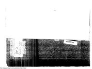
In 1927, Arkansas City on the Lower Mississippi River was affected by a break 60 miles upstream.<br />
U.S. Army Corps of Engineers File Photo<br />
During the previous 200 years, local governments had paid an estimated $292<br />
million in lower Mississippi flood protection works. Now in a single act, the Congress<br />
authorized expenditures of $325 million. 21 Reuss stated that “probably no other water<br />
project involved as great a percentage of the federal budget at the time of its authorization<br />
as did Mississippi Valley flood control.” 22<br />
<strong>The</strong> <strong>Flood</strong> Control Act of 1936. Early in 1936, the New England region suffered from its<br />
worst flood in at least 300 years. That same year, paralyzing floods occurred in the upper<br />
Ohio River basin, taking 184 lives and causing about $200 million in property damage.<br />
In the wake of the devastation, a flood relief bill already drawn up was expanded into a<br />
bill to establish a national policy of river development for flood control. 23<br />
<strong>The</strong> Great Depression of the 1930s established the historical context that led to<br />
the <strong>Flood</strong> Control Act of 1936. 24 This economic catastrophe created an urgent need for<br />
work relief projects but communities and states—already in financial straits—found it<br />
impossible to undertake such projects themselves. Consequently, Congress and the<br />
21 Clark, p. 78.<br />
22 Reuss, Designing the Bayous: <strong>The</strong> Control of Water in the Atchafalaya Basin, 1800-1995. (Alexandria, VA: Office of History, U.S. Army Corps of<br />
Engineers, 1998), p. 121.<br />
23 Moore and Moore, p. 12.<br />
24 P.L. 74-738.
<strong>The</strong> Early 20th Century: A Growing Federal Interest 11<br />
President authorized some, though hardly all, otherwise marginal flood control projects in<br />
order to provide jobs. <strong>The</strong> act provided for constructing some 250 projects using work<br />
relief moneys. It appropriated $310 million to initiate construction and $10 million to<br />
carry out numerous examinations and surveys. 25 <strong>The</strong> act’s Declaration of Policy stated<br />
that:<br />
it is hereby recognized that destructive floods upon the rivers of the<br />
United States, upsetting orderly processes and causing loss of life and<br />
property, including the erosion of lands, and in impairing and obstructing<br />
navigation, highways, railroads, and other channels of commerce<br />
between the States, constitute a menace to national welfare; that it is the<br />
sense of Congress that flood control on navigable waters or their<br />
tributaries is a proper activity of the Federal Government in cooperation<br />
with States, their political subdivisions, and localities thereof; that<br />
investigations and improvements of rivers and other waterways,<br />
including watersheds thereof, for flood-control purposes are in the<br />
interest of the general welfare; that the Federal Government should<br />
improve or participate in the improvement of navigable waters or their<br />
tributaries, including watersheds thereof, for flood-control purposes if the<br />
benefits to whomsoever they may accrue are in excess of the estimated<br />
costs, and if the lives and social security of people are otherwise<br />
adversely affected. 26 (emphasis added)<br />
<strong>The</strong> <strong>Flood</strong> Control Act of 1936 set up a two-pronged attack on the problem of<br />
reducing flood damages. On one side, the Department of Agriculture would develop<br />
plans to reduce runoff and retain more rainfall where it fell. On the other, the Corps<br />
would develop engineering plans for downstream projects. In theory, the plan required<br />
cooperation between the two agencies but included no mechanism to ensure coordination.<br />
In reality, the major work fell to the Corps.<br />
FEDERAL GOVERNMENT ASSUMES LARGER ROLE<br />
Record floods in the Ohio River basin in 1937 helped to sharpen federal policy<br />
enunciated by the 1936 act. Twenty-two states were affected, 244 lives were lost, and<br />
$31 million in relief expenditures were required. As a consequence, Congress enacted<br />
the <strong>Flood</strong> Control Act of 1938. This act authorized the construction of a large number of<br />
basin-wide flood control plans prepared under the authority of the 1936 Act. Cost-sharing<br />
provisions were also changed, providing for federal assumption of the entire cost of both<br />
reservoir and channel modification projects. <strong>The</strong> <strong>Flood</strong> Control Act of 1941 further<br />
modified the 1938 provision by making channel modifications subject to cost sharing.<br />
25 Moore and Moore, p. 13.<br />
26 Arnold, Appendix A.
12<br />
<strong>The</strong> Nation’s <strong>Responses</strong> to <strong>Flood</strong> <strong>Disasters</strong>: A <strong>Historical</strong> <strong>Account</strong><br />
<strong>The</strong>se policies did not change significantly until after a 1966 report from a Bureau of the<br />
Budget Task Force on Federal <strong>Flood</strong> Control Policy (see Chapter 3, “Bureau of the<br />
Budget Task Force”) recommended a unified national program for managing flood<br />
losses.<br />
In 1954, federal involvement in flood control was again broadened when<br />
Congress enacted the Watershed and <strong>Flood</strong> Prevention Act, 27 which authorized flood<br />
protection structures in upstream watersheds (defined as smaller than 250,000 acres).<br />
This act authorized the U.S. Department of Agriculture’s (USDA) Soil Conservation<br />
Service (SCS) (now the Natural Resources Conservation Service (NRCS)) to participate<br />
in comprehensive watershed management projects in cooperation with states and their<br />
subdivisions. It remains the authority for the USDA’s federally-assisted watershed<br />
projects.<br />
Between 1936 and 1952, during the height of building activity, Congress spent<br />
more than $11 billion for flood control projects that were built primarily to store<br />
floodwaters. This massive construction program subsequently prevented substantial flood<br />
damages. Initially, Congress tended to think in terms of single-purpose flood control<br />
projects but later adopted the important concept of comprehensive and coordinated<br />
development of the resources of the nation’s major river basins.<br />
In a retrospective view of the nation’s responses to flood disasters, Adler 28 states<br />
that the mission-oriented flood control laws of the early 20th century, were due, in part,<br />
to the prevailing view that we could build our way out of almost any problem, with<br />
engineers revered in American society then as only rock stars and sports heroes are today.<br />
Many still believe technology can be used to control nature, 29 although engineers no<br />
longer enjoy such reverence in our society.<br />
27 P.L. 83-566<br />
28 Adler, Robert W., “Addressing Barriers to Watershed Protection,” Environmental Law, 25(1995), p. 1013.<br />
29 See Dennis S. Mileti, Disaster by Design: A Reassessment of Natural Hazards in the United States. (Washington, DC: National Academy Press, 1999).
3<br />
THE 1930S TO THE 1960S:<br />
BROADENING SOLUTIONS TO THE<br />
NATION’S FLOOD PROBLEMS<br />
<strong>The</strong> nation now moved closer to a balanced<br />
approach to flood hazards.<br />
CALLS FOR A BROADER APPROACH<br />
Even as federal involvement in controlling floods through structural works<br />
increased, calls came for a more comprehensive approach to the nation’s flood problems<br />
due to some disturbing trends that had developed by the mid-1950s. Both the potential<br />
nationwide damage from flooding and the cost of protection were rising. America’s<br />
rapidly increasing urban population lay at the heart of the problem. <strong>The</strong> national flood<br />
damage potential was increasing faster than it could be controlled under existing flood<br />
protection construction programs. With this in mind, many pointed out the fallacy of<br />
relying entirely on measures to redirect the paths of flood waters, citing lessons learned<br />
from the “levees only” policy adopted some 75 years earlier for the lower Mississippi<br />
River Valley. Others saw wise land use management practices within floodprone areas as<br />
a neglected alternative to construction programs.<br />
EVOLVING VIEWS ON HUMAN ADJUSTMENT TO FLOODS: HARLAN<br />
H. BARROWS AND GILBERT F. WHITE<br />
<strong>The</strong>se cries of concern as to how we, as a nation, use our floodplains, did not<br />
originate in the 20th century. A report issued in the early 1850s, at the direction of the<br />
Congress, insisted the flood problem in the Mississippi River delta was growing because<br />
more cultivation was taking place in the floodplain. 30 W J McGee, in his 1891 article<br />
30 Ellet, 1853.
14<br />
<strong>The</strong> Nation’s <strong>Responses</strong> to <strong>Flood</strong> <strong>Disasters</strong>: A <strong>Historical</strong> <strong>Account</strong><br />
“<strong>The</strong> <strong>Flood</strong>plains of Rivers,” published in Forum, XI, stated that “as population has<br />
increased, men have not only failed to devise means for suppressing or for escaping this<br />
evil [flood], but have with singular short-sightedness, rushed into its chosen paths.” 31<br />
Harlan H. Barrows. In a report on the evolution of federal flood control policy, Moore<br />
and Moore state that the concepts that would eventually alter national approaches to flood<br />
problems probably began in the 1920s with the work of Harlan H. Barrows. 32 Barrows, a<br />
professor of Geography at the University of Chicago and a member of the Public Works<br />
Administration’s Mississippi Valley Committee (which would later become the Water<br />
Resources Committee) had the widest possible view of the geography and espoused a<br />
need for interdisciplinary research. He inspired his students to look at the world in a<br />
similar fashion.<br />
As one of two non-engineers on the Roosevelt administration’s 12-member<br />
Water Resources Committee (WRC) in the late 1930s, Barrows had ample opportunities<br />
to promote his belief that good planning required linking land and water use. He<br />
expressed his views in a report 33 prepared by the WRC for the President in 1938. With<br />
one notable exception, all sections of the drainage report reflected the engineering<br />
orientation of most of its authors and generally endorsed structural solutions to water<br />
problems. <strong>The</strong> exception was the section submitted by the Ohio-Lower Mississippi<br />
Regulation Subcommittee, which Barrows chaired. <strong>The</strong> report stated “if it would cost<br />
more to build reservoir storage than to prevent floodplain encroachment, all relevant<br />
factors considered, the latter procedure would appear to be the best solution.” Reuss 34<br />
described this section of the report as containing some remarkable language. Reuss goes<br />
on to state that:<br />
for the first time, an official government document recommended<br />
something other than building dams, floodwalls, and levees to protect life<br />
and property. Barrows’ subcommittee (which included the Chief of<br />
Engineers) recommended the consideration of zoning laws and<br />
relocation. It warned that flood control reservoirs simply promoted the<br />
occupation of previously flood-prone lands, and this inevitably produced<br />
new demands for protection. <strong>The</strong> WRC’s receptivity to the<br />
subcommittee report must have encouraged Barrows. <strong>The</strong> full<br />
committee explicitly noted that most of the subcommittee<br />
recommendations applied equally to other basins and were ‘essential<br />
elements in a sound national flood-control policy.’ Barrows was not<br />
content to publish his views in the drainage report. He looked for a<br />
definite change in policy. When President Roosevelt forwarded to the<br />
31 McGee, W. J., “<strong>The</strong> <strong>Flood</strong>plains of Rivers,” Forum, XI(1891), p. 221.<br />
32 Moore and Moore, p. 35.<br />
33 Water Resources Committee, Drainage Basin Problems and Program, (National Resources Committee, 1938).<br />
34 Reuss, “Coping With Uncertainty: Social Scientists, Engineers, and Federal Water Resources Planning,” Natural Resources Journal, 32(Winter 1992), p.<br />
119.
<strong>The</strong> 1930s to the 1960s: Broadening Solutions to the Nation’s <strong>Flood</strong> Problems 15<br />
WRC in January 1938, a Corps of Engineers document calling for the<br />
construction of 82 reservoirs in the Ohio and Mississippi River basins,<br />
Barrow wrote Abel Wolman, who headed the WRC, that further studies<br />
were needed. <strong>The</strong>n he noted ‘the practicability of avoiding flood<br />
damages by zoning valley bottoms and by other remedial measures with<br />
respect to the occupation and use of flood plains has not been sufficiently<br />
explored.’ Wolman personally took Barrows’ concerns to the President<br />
in April 1938. Repeating Barrows’ message, Wolman emphasized to the<br />
attentive President that more studies were necessary.<br />
<strong>The</strong> need for more studies temporarily ended<br />
further construction proposals.<br />
Gilbert F. White. Among those who studied under<br />
Barrows was a bright, young aspiring geographer named<br />
Gilbert F. White. In 1934, having completed all the<br />
requirements for his doctorate except a dissertation,<br />
White went to work for Barrows in Washington, DC and<br />
stayed eight years in government service. His work for<br />
Barrows decisively influenced White. While on the<br />
staff of the Mississippi Valley Committee and of the<br />
Water Resources and Land Resources committees,<br />
White probed deeply into the issues of floodplain<br />
occupancy. Like others in the Roosevelt administration,<br />
he concluded that many current problems (floods, dust<br />
bowl, etc.) were the inevitable result of human<br />
modification of natural conditions. In 1936, in what<br />
would become a broad thesis, White asked if land use<br />
planning were not an effective alternative as a method of<br />
reducing flood damage.<br />
GILBERT WHITE<br />
Natural Hazards Center File<br />
Photo<br />
At a national conference on planning in 1938, White suggested that federal funds<br />
for constructing flood control dams in California should not be authorized unless the state<br />
enacted legislation to control any further encroachments upon floodplains. Word of those<br />
views reached the California delegation. Shortly thereafter, the appropriate Congressional<br />
committee was directed to investigate the youthful staff member of the National<br />
Resources Planning Board 35 who was promoting “un-American” ideas. White survived<br />
the congressional hearing, and the dams were authorized without any such conditions. 36<br />
35 <strong>The</strong> National Resources Planning Board was created by President Roosevelt in 1934 to serve as an advisory body to the Administration on resource planning<br />
within the federal government.<br />
36 White, Gilbert F., Looking <strong>To</strong>ward the Horizon: Prospects for <strong>Flood</strong>plain Managers, (Association of State <strong>Flood</strong>plain Managers Annual Conference, Little<br />
Rock, AK, 1997).
16<br />
<strong>The</strong> Nation’s <strong>Responses</strong> to <strong>Flood</strong> <strong>Disasters</strong>: A <strong>Historical</strong> <strong>Account</strong><br />
White penned his Doctor of Philosophy dissertation, entitled Human Adjustment<br />
to <strong>Flood</strong>s, 37 in 1942. He based the document on his own views and experiences, his<br />
knowledge of the history of the government programs with which he had been involved,<br />
and the evidence and ideas surrounding floodplain management that surfaced within the<br />
Water Resources Committee. In it, he characterized the prevailing national policy as<br />
“essentially one of protecting the occupants of floodplains against floods, of aiding them<br />
when they suffer flood losses, and of encouraging more intensive use of floodplains.” 38<br />
He instead advocated “adjusting human occupancy to the floodplain environment so as to<br />
utilize most effectively the natural resources of the floodplain, and at the same time, of<br />
applying feasible and practicable measure for minimizing the detrimental impacts of<br />
floods.” 39<br />
Many were convinced that his concepts offered a real alternative to existing flood<br />
control practices. Among those were Harvard professor Arthur Maass who, in his 1951<br />
book Muddy Waters, 40 presented White’s concepts to a broader audience. In 1955, two<br />
noted hydrologists, William G. Hoyt and Walter B. Langbein, also endorsed White’s<br />
concepts in their book <strong>Flood</strong>s. <strong>The</strong> authors traced the evolution of public flood control<br />
policies, laid out current problems, and suggested that changes were needed. “Our<br />
present policy towards floods hinges essentially on water control,” they said. “It seems<br />
imperative to have, in addition to a policy of control, a comprehensive national policy of<br />
flood management.” 41 Gilbert F. White later characterized their work as the first to<br />
coherently pull together the scientific information about floods, an effort respected by<br />
scientific groups. It is widely accepted that Gilbert F. White’s seminal study stimulated<br />
the interest and set the course for the emergence and evolution, in ensuing decades, of<br />
broader approaches to flood problems.<br />
LAND USE PLANNING: A. J. GRAY, JIM GODDARD, AND THE TVA<br />
EXPERIMENT<br />
<strong>The</strong> Tennessee Valley Authority (TVA) was the first federal agency to broadly<br />
apply alternative approaches to control flood damage, choosing to add land use planning<br />
methods to the popular structural measures already used to control the paths of<br />
floodwaters. Congress created the TVA in 1933 as a government corporation armed with<br />
power to plan, build, and operate multipurpose water resource development projects<br />
within the 40,000 square mile Tennessee River basin. 42 Having basically completed its<br />
initial mission of bringing about the maximum degree of flood control feasible along the<br />
37 White, Human Adjustment to <strong>Flood</strong>s, A Geographic Approach to the <strong>Flood</strong> Problem in the United States, (University of Chicago, Department of Geography,<br />
1942).<br />
38 White, p. 32.<br />
39 White, p. 2.<br />
40 Maass, Arthur, Muddy Waters, <strong>The</strong> Army Engineers and the Nation’s Rivers. (Boston, MA: Harvard University Press, 1951).<br />
41 Hoyt, William and Walter Langbein, <strong>Flood</strong>s, (Princeton, NJ: Princeton University Press, 1955), pp. 91-113.<br />
42 President Roosevelt proposed extension of the TVA concept to other basins such as the Arkansas, White, and Red, but Congress was never willing to extend<br />
such authority or duplicate it.
<strong>The</strong> 1930s to the 1960s: Broadening Solutions to the Nation’s <strong>Flood</strong> Problems 17<br />
Tennessee River and its major tributaries, TVA turned its attention to the many areas of<br />
the basin that received little or no flood protection from its floodwater detention reservoir<br />
system.<br />
Instrumental was the 1950 internal report Major<br />
<strong>Flood</strong> Problems in the Tennessee River Basin. 43 This<br />
report noted that many communities had flood problems but<br />
because of insufficient development in floodprone areas,<br />
flood control projects could not be justified. <strong>The</strong> only<br />
remedy proposed was that TVA establish a flood warning<br />
system throughout the basin to warn people living in flood<br />
plains of impending disasters. As Chairman of the TVA<br />
Board, Gordon Clapp reacted to the report by saying, “what<br />
should TVA do, wait for development of the flood plains so<br />
that a flood control project could be justified?” 44 He<br />
recommended that the report be circulated to other TVA<br />
staff, particularly the Division of Regional Studies, to get<br />
other reactions and possible alternative approaches to the<br />
problem.<br />
Aldred. J. “Flash” Gray directed the Regional<br />
Studies staff. Gray knew of White’s earlier writings<br />
concerning alternative approaches to the resolution of flood<br />
problems. As a fellow geographer, he understood those<br />
concepts. He, and other TVA staff, would take White’s<br />
ideas and make them an operational program.<br />
JIM GODDARD<br />
ASFPM File Photo<br />
Gray viewed flood damage prevention planning as only being successful if it was<br />
part of comprehensive community planning. <strong>The</strong> problem, as he viewed it, was lack of<br />
land use planning and not a flood warning issue. After its review of the report, the<br />
Regional Studies staff proposed an entirely different approach to the problem. <strong>The</strong> staff<br />
started with the proposition that the problem related primarily to the control of land use<br />
and development in areas subject to flooding and that the state and local planning staffs<br />
must have a key role in any regional or local effort to minimize flood hazards. <strong>The</strong>y<br />
proposed that the new approach be tried in Tennessee, which had a strong state planning<br />
agency under the leadership of Harold Miller, as well as a strong program of local<br />
planning assistance. Under this approach, TVA and the state staffs would join in a<br />
technical appraisal of the possible application of flood data to planning programs. <strong>The</strong><br />
joint appraisal would include research into the types and forms of flood information<br />
needed by state and local planning programs and how such data might be applied to<br />
community planning, land use controls, and capital improvement programs. According<br />
43 Interview with A. J. Gray, 1 April 1994; In the interview, Gray gave me a copy of a draft document he had prepared about early TVA involvement in<br />
addressing flood problems. His report was never published and was a rough working draft.<br />
44 From an unpublished draft report by A. J. Gray.
18<br />
<strong>The</strong> Nation’s <strong>Responses</strong> to <strong>Flood</strong> <strong>Disasters</strong>: A <strong>Historical</strong> <strong>Account</strong><br />
to Gray, sometime during its early work in this area, TVA coined the term “floodplain<br />
management.”<br />
TVA was well positioned to carry out its role. In its earlier water resource<br />
development activities, TVA had gathered data on historic floods and investigated the<br />
potential magnitude of future floods within the basin. <strong>The</strong> agency, therefore, had the<br />
database and engineering capability to define the flood problems at any location in the<br />
Tennessee River basin. TVA also had the breadth of staff⎯engineers, economists, city<br />
planners⎯that could put this new planning concept into operation. <strong>The</strong> agency had also<br />
carefully developed a good working relationship with state and local governments and<br />
organizations.<br />
Because of its primary role as a data gathering body, the Regional Studies staff<br />
could not handle the technical issues involved in defining local flood problems. Jim<br />
Goddard, a TVA engineer, was selected to help lead the ongoing investigations. Goddard<br />
was instrumental in designing the two-section reports that would provide an<br />
understanding of the nature and magnitude of flood problems in specific communities or<br />
areas and that would be used at the local planning level. <strong>The</strong> report’s first section<br />
provided an analysis of the history of floods in the community, information on the size of<br />
floods that could reasonably be expected in the future, and maps showing the areas<br />
covered by these floods. <strong>The</strong> second section indicated the size of the floodway needed to<br />
pass floods downstream, defined the types of uses that might be permitted in such areas,<br />
and delineated the flood fringe area beyond the floodway where further development<br />
could be permitted, subject to appropriate adjustment to the flood risk. 45<br />
In 1953, TVA embarked on a pioneer cooperative program to tackle local flood<br />
problems. TVA, in cooperation with each of the Tennessee River watershed states,<br />
prepared an initial list of 150 communities with significant, known flood problems and<br />
agreed upon an order for undertaking factual flood hazard information studies.<br />
Communities having the most urgent need could request a study and report on their flood<br />
problems from the TVA, which funded the entire process.<br />
This offer of free flood hazard information did not meet with universal<br />
acceptance. <strong>The</strong>re were those communities that, for various reasons, did not want their<br />
flood problems publicized. <strong>The</strong>re were others that did not want the federal or state<br />
governments “meddling” in local affairs. Many communities were not interested in the<br />
data until after the occurrence of a new flood event in their locality. Some made the<br />
request because the state planner who assisted them recommended they do so. A few<br />
asked for the study as a routine action: they applied for any program which was free of<br />
charge. 46<br />
45 Ibid.; <strong>The</strong> concepts of the floodway and flood fringe as part of floodplain regulations were also originated by TVA.<br />
46 <strong>Flood</strong>plain Management: <strong>The</strong> TVA Experience, (Knoxville, TN: Tennessee Valley Authority, December 1983), p. 16.
<strong>The</strong> 1930s to the 1960s: Broadening Solutions to the Nation’s <strong>Flood</strong> Problems 19<br />
<strong>The</strong> flood hazard information developed by TVA for the early reports included<br />
data on historic floods and a future hypothetical flood termed the “maximum flood of<br />
reasonable regional expectancy.” This hypothetical flood measure led to numerous<br />
problems for its potential use in local land use planning. <strong>The</strong>se problems included its<br />
unwieldy name and its unlikely occurrence. On the other hand, TVA was hesitant to<br />
develop a lesser flood measure since this might imply that it was recommending a lesser<br />
planning standard. <strong>The</strong> strong difference of opinion among TVA engineers and others<br />
over the development of a hypothetical flood suitable for land use planning purposes was<br />
a considerable problem that significantly retarded the early progress of TVA’s floodplain<br />
management assistance program.<br />
<strong>To</strong> solve this impasse, two hypothetical floods were computed: the “maximum<br />
probable” and the “regional.” At that time, the TVA used the maximum probable flood<br />
to design flood control works. <strong>The</strong> maximum probable flood’s computed size was<br />
equivalent to the Corps’ “standard project flood” and was generally larger than the<br />
TVA’s flood of reasonable regional expectancy. Determining the regional flood size<br />
involved defining a flood comparable in magnitude to the largest known floods on similar<br />
streams within 60 to 100 miles of the stream reach under study. <strong>The</strong> regional flood for<br />
most streams studied was significantly smaller than the flood of reasonable regional<br />
expectancy or maximum probable flood and rapidly became the standard for floodplain<br />
regulations within the basin. TVA engineers thought it was large enough to use in<br />
planning, and state planners felt it was fair and reasonable since it was based on actual<br />
flood occurrences in the vicinity of the studied streams. <strong>The</strong>refore, local officials and<br />
citizen members of the planning commission, who would ultimately be called upon to<br />
enforce the regulations, rapidly embraced it. <strong>The</strong> basic data in the TVA flood hazard<br />
information reports would not change substantially until the mid-1970s when the “100year,”<br />
and sometimes the “500-year,” flood profiles and flooded area outlines were<br />
included, generally in response to the requirements of the National <strong>Flood</strong> Insurance<br />
Program (NFIP). 47<br />
Goddard and his staff were primarily responsible for preparing local flood<br />
studies, while Gray and his staff were responsible for working with state and local<br />
planners to adjust the land use in areas subject to flooding. Demonstrations in a few<br />
Tennessee communities, such as Athens, Lewisburg and Pulaski, were an immediate<br />
success instigating the program’s rapid spread to communities throughout the basin. By<br />
1965, TVA had prepared 92 floodplain information reports covering 112 communities.<br />
Forty-three had officially adopted floodplain regulations in their zoning ordinances or<br />
subdivision regulations or both. 48<br />
Goddard and Gray applied their leadership and energy by first working with state<br />
and local governments in the Tennessee River watershed encouraging a full range of<br />
47 Ibid., p. 17.<br />
48 Annual Report for Fiscal Year 1965, (Knoxville, TN: Tennessee Valley Authority, Division of Water Control Planning, 1965).
20<br />
<strong>The</strong> Nation’s <strong>Responses</strong> to <strong>Flood</strong> <strong>Disasters</strong>: A <strong>Historical</strong> <strong>Account</strong><br />
policies and actions for ensuring wise use of floodprone lands and later in sharing the<br />
TVA experience nationally. TVA files contain dozens of papers advancing the concepts<br />
and application of floodplain management principles and practices that they and their<br />
staffs presented at regional and national conferences in the 1950s and 1960s. Goddard, a<br />
man of great energy, unrelenting dedication, and strong-will, was particularly active in<br />
this endeavor. His personality was well suited to being in the limelight. Gray was more<br />
reserved, but equally effective.<br />
Goddard sought permission to reproduce and distribute every document he<br />
discovered on the subject during this period. Through this process, more than 200<br />
documents were reprinted and distributed throughout the nation. Under his direction,<br />
TVA supported a series of pioneering, nationally significant academic studies, such the<br />
first comprehensive floodproofing study by John R. Sheaffer in 1960 as part of a<br />
University of Chicago Geography Department dissertation, 49 in the field of floodplain<br />
management. Goddard’s seemingly inexhaustive activity continued into his later work<br />
with the Corps in the mid-1960s and for several decades thereafter.<br />
After only a few years of experience, TVA was convinced that this floodplain<br />
management assistance program had real merit and was suitable for national application.<br />
TVA transmitted a report to Congress in 1959 proposing a program to reduce the national<br />
flood damage potential. 50 In the Letter of Transmittal, the TVA stated that it “believes<br />
that local communities have the responsibility to guide their growth so that their future<br />
development will be kept out of the path of floodwaters. With the States and<br />
communities of the Tennessee Valley, TVA has developed a means of putting this<br />
proposition into action.” <strong>The</strong> report spelled out past uses of TVA’s flood reports. At<br />
Lewisburg, Tennessee, flood data were used to prevent development of two proposed<br />
subdivisions in areas subject to frequent flooding. If finished, the development would<br />
have been flooded the following year. Officials in Chattanooga, Cleveland, Dayton, and<br />
Spring City, Tennessee. used the flood data in locating public buildings and facilities.<br />
Lacking local land use regulations, Maggie, North Carolina, used the data to plan<br />
development. Knoxville and Shelbyville, Tennessee, reduced flood damage by using the<br />
flood information in planning urban renewal projects.<br />
<strong>The</strong> report’s transmittal letter went on to state “this experimental program…is<br />
saving lives and property in the area while diminishing the future demands on the nation<br />
for flood-relief and flood-control expenditures. We believe the same results can be<br />
accomplished by adapting this experience to other areas throughout the United States.<br />
<strong>The</strong> pace of river control development in relation to the even greater rate of urban<br />
encroachment makes it urgent that this broader concept be made a part of our national<br />
flood control policy.” An appendix to the report presented a detailed plan for flood<br />
49 Sheaffer, John R., <strong>Flood</strong> Proofing: An Element in a <strong>Flood</strong> Damage Reduction Program, (University of Chicago, Department of Geography, Research Paper<br />
No. 65, 1960).<br />
50 U.S. Senate Committee on Public Works, A Program for Reducing the National <strong>Flood</strong> Damage Potential, 86th Cong., 1st sess., 31, Aug. 1959.
<strong>The</strong> 1930s to the 1960s: Broadening Solutions to the Nation’s <strong>Flood</strong> Problems 21<br />
damage reduction at Lewisburg, Tennessee. This plan was likely intended as an example<br />
of the TVA and state-assisted planning effort carried out at the local level and as an<br />
illustration of the level of floodplain management assistance envisioned in the TVA<br />
proposal for reducing the national flood damage potential.<br />
<strong>Flood</strong>plain management formally entered the federal agenda when TVA<br />
transmitted their 1959 report on reducing national flood damage. It could not have come<br />
at a better time. Due to an increasing urban population, potential damage and protections<br />
costs from floods were rising faster than could be controlled under existing flood<br />
protection construction programs. On average, between 1900 and 1948, the United States<br />
experienced floods causing $50 million or more in damages about once every six years.<br />
Between 1940 and 1960, despite the fact floods did not increase in magnitude or<br />
frequency, the $50 million total was exceeded about every two years. 51 With this in<br />
mind, studies and programs on wise land use management practices within floodprone<br />
areas began to gain acceptance.<br />
THE UNIVERSITY OF CHICAGO STUDIES<br />
Gilbert F. White returned to University of Chicago in 1955 as a member of the<br />
Geography Department after serving nine years as president of Haverford College. Upon<br />
his return, he turned to his previous research interest on floodplain occupance. 52 White<br />
thought it would be a good idea to find out what had been happening to the nation’s<br />
floodplains since enactment of the 1936 <strong>Flood</strong> Control Act. This idea, with the support<br />
of Resources for the Future, started a series of research activities on floodplain occupancy<br />
and its implications.<br />
A 1958 study by White and others entitled Changes in Urban Occupance of<br />
<strong>Flood</strong> Plain 53 revealed what had been happening during the last two decades. <strong>The</strong> study’s<br />
findings were discussed in a special workshop attended by representatives from a number<br />
of federal agencies, including the Corps. With land use pressures and few incentives to<br />
stay out of the hazard areas, floodplain occupancy was increasing⎯even in urban areas<br />
where population was declining. Federal programs, principally highway construction,<br />
urban renewal, and the construction of flood protection works, accelerated growth in<br />
flood hazard areas. Federal incentives were creating a new perception that if a serious<br />
flood hazard developed, the federal government would somehow deal with it. Ignoring<br />
the possibility of a flood disaster, individuals and public facilities were moving to and<br />
building in the floodplain thus contributing to the rising level of flood damage with each<br />
passing year.<br />
51 Moore and Moore, p. 37.<br />
52 Reuss, Martin, Water Resources People and Issues, Interview with Gilbert F. White (Office of History, U.S. Army Corps of Engineers, Ft. Belvoir, VA,<br />
January 1993), p. 34.<br />
53 White, et. al, Changes in Urban Occupance of <strong>Flood</strong> Plains, (University of Chicago, Department of Geography, Research Paper No. 57, November 1958).
22<br />
<strong>The</strong> Nation’s <strong>Responses</strong> to <strong>Flood</strong> <strong>Disasters</strong>: A <strong>Historical</strong> <strong>Account</strong><br />
One of the main topics identified by workshop attendees was the role of<br />
floodplain regulations in bringing about changes. However, more research was needed to<br />
fully understand the issue. <strong>The</strong> University wanted to include views from engineers in the<br />
Corps, the key water resources agency. <strong>To</strong> assist, Francis C. Murphy, an engineering<br />
planner in the flood control field, was chosen to come to Chicago and work with the<br />
Geography Department. His 1958 study Regulating <strong>Flood</strong> Plain Development. 54 stated<br />
that no more than eight communities had enacted floodplain zoning before 1955 and<br />
listed the 49 that had ordinances in 1958. According to Murphy, provisions concerning<br />
development in floodprone areas started to appear in floodplain regulations after World<br />
War II. He was not able to find or compile a list of cities utilizing subdivision regulations<br />
to regulate development in floodplains but stated that “their number is certainly far<br />
greater than the number of cities which have adopted flood-plain provisions in their<br />
zoning ordinances.” 55 <strong>To</strong> convince others of the need for more regulations, he argued<br />
that regulating development on the floodplain was a necessary and practicable way to<br />
reduce the drain of both floods and protective measures on the national economy. He<br />
pointed out that governments were reluctant to enact land use management practices<br />
because they had no flood maps or other data that indicated the extent and character of<br />
local flooding. As a first step, he recommended programs to assist communities in<br />
obtaining comprehensive flood risk reports.<br />
Collectively, these and other cited studies provided valuable information for<br />
policy makers regarding what had happened in the nation’s floodplains during the<br />
preceding three decades. <strong>The</strong>se University of Chicago research studies were<br />
revolutionary because they introduced ideas about: 56<br />
• the role of perception in looking at alternative methods of dealing with flood<br />
losses; 57<br />
• the decision making processes surrounding floodplain land use; 58<br />
• how industrial groups respond to flood hazards; 59 and<br />
• the differences between agricultural approaches and urban approaches in<br />
addressing flood hazards. 60<br />
54 Murphy, Francis C., Regulating <strong>Flood</strong>plain Development, (University of Chicago, Department of Geography, Research Paper No. 56, November 1958).<br />
55 Murphy, p. 87.<br />
56 Interview with Gilbert F. White, 20 July 1994.<br />
57 Kates, Robert W., Hazard and Choice Perception in <strong>Flood</strong>plain Management, (University of Chicago, Department of Geography, Research Paper No. 78,<br />
1962).<br />
58 White, Choice of Adjustment to <strong>Flood</strong>s, (University of Chicago, Department of Geography, Research Paper No. 93, 1964).<br />
59 Kates, Robert W., Industrial <strong>Flood</strong> Losses: Damage Estimation in the Lehigh Valley, (University of Chicago, Department of Geography, Research Paper No.<br />
98, 1965).<br />
60 Burton, Ian, Types of Agricultural Occupance of <strong>Flood</strong> Plains in the United States, (University of Chicago, Department of Geography, Research Paper No.<br />
75, 1962).
<strong>The</strong> 1930s to the 1960s: Broadening Solutions to the Nation’s <strong>Flood</strong> Problems 23<br />
THE FIRST URBAN FLOODPLAIN MAPPING STUDY<br />
During this same time, the Northeastern Illinois Metropolitan Planning<br />
Commission, created in the 1950s to plan growth in the Chicago metro area,<br />
demonstrated what could be done in a region when a metropolitan area works in<br />
conjunction with a regional land use planning group. A committee, co-chaired by White,<br />
arranged to have the region’s floodplains mapped and helped develop a floodplain<br />
management program. This was the first time a metropolitan area in the United States<br />
was so mapped. <strong>The</strong> Cook County Forest Preserve District, the nation’s largest, supplied<br />
financial support when they learned that mapping would make it easier to acquire land in<br />
hazardous areas that could advance the Preserve’s goals. Fresh from preparing a floodhazard<br />
map for <strong>To</strong>peka, Kansas, the U.S. Geological Survey (USGS) provided technical<br />
support for the mapping. This venture affected subsequent USGS mapping efforts by<br />
drawing the agency into this type of activity. White characterized the work of the<br />
Commission and District as a pioneering effort in floodplain mapping and in<br />
demonstrating that floodprone lands could be used for multiple purposes that excluded<br />
residential and commercial development. 61<br />
REGULATING FLOODPLAINS: AN IDEA WHOSE TIME HAD COME<br />
<strong>The</strong> 1960 census and subsequent changes in congressional districts and<br />
representation resulted, for the first time in the nation’s history, in a majority of members<br />
in the House of Representatives from urban areas. This brought about changes in<br />
programs and methods to address national problems. Urban problems received more<br />
attention and resources. Water resource development projects, including flood control,<br />
received less Congressional support. During this time, a growing national environmental<br />
movement became better organized, more vocal, and more influential in the need to<br />
protect and preserve natural resources. Its impact culminated in the adoption of the<br />
National Environmental Policy Act (NEPA) at the end of the decade and the creation of<br />
the U.S. Environmental Protection Agency (EPA).<br />
National demographic changes, including a more affluent and mobile population,<br />
led to greater coastal development that placed more people and property in the paths of<br />
coastal storms. A growing recognition of the rising cost of annual flood losses resulted as<br />
a consequence of several major hurricanes and riverine flood events that occurred around<br />
this time.<br />
<strong>The</strong> support that the 1958 White and Murphy studies received, the growing loss<br />
of property and cost of flood damage, and other developments, suggested that regulating<br />
floodplain land use was an idea whose time had come. This idea was endorsed by the<br />
Council of State Governments during a two-day conference on floodplain regulation and<br />
61 White, 20 June 1994.
24<br />
<strong>The</strong> Nation’s <strong>Responses</strong> to <strong>Flood</strong> <strong>Disasters</strong>: A <strong>Historical</strong> <strong>Account</strong><br />
flood insurance held December 1958 in Chicago, one month after White and Murphy<br />
published their studies. Delegates recommended that one federal agency be directed by<br />
Congress to cooperate with other federal agencies and state governments to prepare<br />
reports providing basic data on flood magnitude and frequency for flood risk areas. In<br />
addition, a number of states began to study local floodplain zoning programs. In April<br />
1959, flood problems were discussed at the Southeastern Water Resources Conference in<br />
Atlanta. Here, Goddard presented the experiences of the TVA to an attentive audience.<br />
Resources for the Future held a roundtable in May where discussion focused on the<br />
recently published White and Murphy studies.<br />
A number of people were interested in new ideas to address the nation’s flood<br />
problems. Views were exchanged in conferences that began to address the relationships<br />
among flood control project construction, a flood insurance program, and floodplain<br />
management. White’s 1964 study Choice of Adjustment to <strong>Flood</strong>s, 62 based on a field<br />
study in LaFollette, Tennessee, critiqued existing methods and practices and addressed<br />
alternative means of dealing with flood problems by occupants, communities, and federal<br />
agencies. His study aided the ongoing discussions and debates concerning the paths that<br />
should be taken and the ways of canvassing the whole range of alternatives for achieving<br />
desirable land use.<br />
THE CORPS’ EXPANDING ROLE IN BROADER APPROACHES<br />
By the late 1950s, Murphy and others had pointed to the lack of basic flood risk<br />
information as a major impediment for communities to consider and carry out regulation<br />
of floodplain development. Prudently anticipating a demand for basic floodplain<br />
information in the future, the Corps prepared draft legislation in 1958 providing for the<br />
systematic collection and dissemination of flood data as a new Corps’ mission. <strong>The</strong> next<br />
series of major floods would activate interest in a national flood insurance program, the<br />
Corps reasoned, and efforts to have some government agency provide the data to serve<br />
both an insurance program and the needs of communities for floodplain regulation would<br />
follow. This was a task the Corps felt it could do. If the agency did not step forward and<br />
volunteer to assume this function, other federal agencies would initiate programs and<br />
preclude a Corps’ role, 63 such as the TVA proved with their initial 1954 and ensuing<br />
community reports.<br />
<strong>The</strong> report of the Senate Select Committee on National Water Resources, 64<br />
published in January 1961, became the vehicle through which the concepts of floodplain<br />
management were officially recommended. <strong>The</strong> report called for major efforts in five<br />
specific categories. Among these was a recommendation that the federal government<br />
62 White, Research Paper No. 93.<br />
63 Moore and Moore, pp. 50-51.<br />
64 Moore and Moore, p. 52.
<strong>The</strong> 1930s to the 1960s: Broadening Solutions to the Nation’s <strong>Flood</strong> Problems 25<br />
delineate flood hazard areas and encourage enactment of land use regulations for the<br />
floodplain. Following up on earlier preparatory work by the Corps, the Congress, in the<br />
<strong>Flood</strong> Control Act of 1960, had already granted authorization for the Corps to compile<br />
and disseminate information on floods and flood damages at the request of a state or<br />
responsible local agency. In response to this Congressional authorization, the Corps<br />
could now carry out expanded floodplain management services such as supplying<br />
communities with flood data, advising on the use of floodplains and local planning, and<br />
preparing local floodplain information studies if asked by the state or locality. <strong>To</strong> carry<br />
out their mandate, the Corps formally established a <strong>Flood</strong>plain Information Services<br />
Program. In preparing local flood studies and providing floodplain information, the<br />
Corps borrowed substantially from the earlier efforts of TVA and the work of Goddard<br />
and White. Between 1962 and 1967, program appropriations averaged around $1 million<br />
annually, rising to around $5 million annually by the end of the decade. 65<br />
With a national program now in place for identifying local flood hazard areas,<br />
there was a need to establish uniform procedures for agencies to use in defining flood<br />
hazards. <strong>The</strong> Corps, with Goddard as its spokesman, chaired a work group of<br />
representatives from 26 federal agencies. 66 In July 1967, the group adopted a draft of<br />
Proposed <strong>Flood</strong> Hazard Evaluation Guidelines for Federal Executive Agencies. This<br />
brief document dealt with methodologies and standards to be used in developing<br />
information about flood hazards, including delineation of the floodplain, elevations that<br />
would be reached by floods of various magnitudes, flood velocities, and the probability<br />
of floods of various magnitudes. <strong>The</strong> 1 percent annual chance flood 67 (referred to as 100year<br />
flood throughout the rest of this document because it is the commonly used,<br />
although inaccurate, term) emerged as a measurement to balance avoiding inordinate<br />
flood losses with avoiding excessive regulation of floodplain development. <strong>The</strong><br />
Guidelines were transmitted to the Bureau of the Budget, which tasked the Water<br />
Resources Council (WRC) (see Chapter 4, “Water Resources Council”) to carry out a<br />
more detailed review, revise where appropriate, and issue the Guidelines. In 1969, the<br />
WRC published revised Guidelines to be reviewed through experimental use by federal<br />
agencies, states, and consultants. 68 <strong>The</strong> revised guidelines defined the floodway as that<br />
portion of the floodplain needed to accommodate passage of the 1 percent annual chance<br />
flood without increasing the level of the flood by more than a “significant amount” (or a<br />
rise of one foot). 69 After comments were received on their use, the guidelines were<br />
further revised and published by the WRC as <strong>Flood</strong> Hazard Evaluation Guidelines for<br />
Federal Executive Agencies in May 1972.<br />
Besides setting up extensive federal guidelines, the Corps published the first<br />
major nationwide inventory of urban places with flood problems in 1967. Some 5,200<br />
65 Ibid., p. 118.<br />
66 Ibid., p. 101.<br />
67 A flood that has a 1 percent chance of being equaled or exceeded in any given year.<br />
68 Proposed <strong>Flood</strong> Hazard Evaluation Guidelines for Federal Executive Agencies, (Water Resources Council, Washington, DC, September 1969).<br />
69 Moore and Moore, p. 102.
26<br />
<strong>The</strong> Nation’s <strong>Responses</strong> to <strong>Flood</strong> <strong>Disasters</strong>: A <strong>Historical</strong> <strong>Account</strong><br />
localities made the list. <strong>The</strong> following year, the Corps authorized the creation of a<br />
<strong>Flood</strong>plain Management Services (FPMS) Branch in the Planning Division of the Office<br />
of Chief of Engineers. George Phippen, a geographer with considerable experience in<br />
water resource planning, was appointed branch chief.<br />
THE U.S. GEOLOGICAL SURVEY’S ROLE<br />
<strong>Historical</strong>ly, the USGS has been actively involved in flood issues and problems.<br />
<strong>Flood</strong> data are documented in a multitude of USGS observations, reports, and<br />
publications. Starting in the mid-1950s, the agency played an important role in<br />
developing procedures still used for estimating flood risk at a particular site.<br />
<strong>The</strong> USGS was also involved in early flood inundation mapping efforts at the<br />
national level by helping to initiate the change from reporting only elevations and<br />
discharges of floods to publishing more interpretative information, such as areas covered<br />
by floods of selected frequencies. For instance, in reporting data on the floods of 1959 in<br />
Ohio, the USGS adopted for the first time, flood-inundation maps as another means of<br />
depicting flood information. Publishing flood-inundation maps delineating boundaries of<br />
inundated areas, providing water surface profiles, and showing flood-frequency relations<br />
became a standard means of reporting about specific floods. 70<br />
In 1954, USGS employee Walter Langbein designed a report format consisting of<br />
a map with pertinent text in the margins. This report became Hydrologic Investigations<br />
Atlas No. 1 (HA-1). <strong>The</strong> successful format was repeated when HA-14 “<strong>Flood</strong>s at<br />
<strong>To</strong>peka, Kansas” was published in 1959, the first of a series of flood atlases for that area.<br />
A second flood atlas, HA-39, “<strong>Flood</strong>s near Chicago Heights, Illinois,” followed in 1960.<br />
<strong>The</strong> third flood atlas published in 1961, HA-41, “<strong>Flood</strong>s at Boulder, Colorado,”<br />
summarized results of a special study of Boulder Creek at Boulder, Colorado, in which<br />
areas inundated by floods of several frequencies were constructed synthetically from past<br />
records and physical surveys of the flood plain.<br />
Interest in the flood maps grew, and cooperative programs with the USGS to map<br />
metropolitan areas rapidly increased in the early 1960s. Following the 1959 flood, the<br />
Ohio Legislature appropriated funds to finance a cooperative agreement with the USGS<br />
to prepare flood atlases for the 12 cities that had suffered the most severe flooding. After<br />
HA-39 was published in 1960, the Northeastern Illinois Metropolitan Planning<br />
Commission entered into an agreement to cooperatively finance a flood-inundation<br />
mapping project for six counties in northeastern Illinois, involving the preparation of<br />
flood atlases for 43 7.5-minute quadrangles. <strong>The</strong> project was later expanded, and 31<br />
additional atlases were completed by 1973. By the end of 1966, USGS had prepared 69<br />
flood atlases at sites in 17 states.<br />
70 Hudson, H. H. and J. S. Cragwell, Jr., A History of the Water Resources Division, U.S. Geological Survey, (vol. VI, 1996).
<strong>The</strong> 1930s to the 1960s: Broadening Solutions to the Nation’s <strong>Flood</strong> Problems 27<br />
THE SOIL CONSERVATION SERVICE PREPARES LOCAL FLOOD<br />
STUDIES<br />
Section 6 of the Watershed Protection and <strong>Flood</strong> Prevention Act of 1954<br />
provided the legislative authority for the SCS to prepare local flood hazard studies.<br />
However, the agency only began preparing the studies after a Bureau of the Budget Task<br />
Force on Federal <strong>Flood</strong> Control Policy (see below, “Bureau of the Budget Task Force”)<br />
recommended it in 1966. By the end of the decade, the SCS had resources to prepare<br />
flood hazard information studies and had technical assistance to offer local officials. 71<br />
Thus, the SCS joined the TVA, the Corps, and the USGS in these efforts to<br />
define flood dangers. In addition, the National Weather Service and the Delaware and<br />
Susquehanna River Basin Commissions prepared a small number of studies in the 1960s<br />
and 1970s. <strong>Flood</strong>plain management measures could now be put into practice.<br />
Engineering techniques were available to produce maps showing areas inundated by<br />
floods of various magnitudes and to define a floodway, along with the provision of other<br />
needed flood data.<br />
SEVERAL STATES LEAD THE WAY IN FLOODPLAIN MANAGEMENT<br />
Murphy reported in 1958 that only seven states (Connecticut, Indiana, Iowa,<br />
Massachusetts, New Jersey, Pennsylvania, and Washington) had enacted and were<br />
enforcing state floodplain management regulations, principally for narrow channel<br />
encroachment areas. Six of these programs were adopted in response to catastrophic<br />
floods. Based on his evaluation of the regulations, he concluded “that they are not in<br />
major conflict with existing developments nor unduly restrictive to new developments.” 72<br />
However, by the late 1960s, a number of states had statutes regulating broader<br />
flood hazard areas: 73<br />
• A 1962 Washington state statute provided that the state establish flood control zones<br />
when data were available for that purpose. Any activity to construct, reconstruct, or<br />
modify any structure or works affecting flood waters within any established zone<br />
required a state permit.<br />
• A 1965 California state code encouraged “local levels of government to plan land use<br />
regulations to accomplish floodplain management and to provide state assistance and<br />
guidance as appropriate.” 74<br />
71 Buie, Eugene C., A History of Water Resource Activities of the United States Department of Agriculture, (U.S. Department of Agriculture, Soil<br />
Conservation Service, 1979).<br />
72 Murphy, p. 16.<br />
73 Regulation of <strong>Flood</strong> Hazard Areas <strong>To</strong> Reduce <strong>Flood</strong> Losses, (U.S. Water Resources Council, vol. 1, Parts I-IV, 1971), pp. 60, 127-175.<br />
74 Ibid., p. 171.
28<br />
TOM LEE<br />
Wisconsin DNR File<br />
Photo<br />
<strong>The</strong> Nation’s <strong>Responses</strong> to <strong>Flood</strong> <strong>Disasters</strong>: A <strong>Historical</strong> <strong>Account</strong><br />
• A 1966 New Jersey act authorized a state agency to delineate and mark flood hazard<br />
areas, to identify reasonable and proper use of these areas according to the relative<br />
risk, and to develop and disseminate other floodplain information.<br />
• A 1967 Nebraska state act established floodway encroachment lines of a 100-year<br />
frequency flood along watercourses by the state, when sufficient data had been<br />
acquired for this purpose. If an affected locality did not then adopt sufficient land<br />
use regulations within these areas, the state’s floodway would be enforced.<br />
• A 1966 comprehensive act enacted by Wisconsin’s state<br />
legislature provided for the adoption of a reasonable and<br />
effective floodplain zoning ordinance by every county,<br />
city, and village before January 1, 1968. If they failed to<br />
do so, the state could adopt an ordinance applicable to the<br />
locality. Regardless of the method of adoption, the<br />
locality was required to administer and enforce the<br />
ordinance. <strong>To</strong>m Lee started as Wisconsin’s first<br />
floodplain management administrator in 1967, modeling<br />
Wisconsin’s state-assisted floodplain management<br />
program after the Iowa program he had started three years<br />
earlier. During his tenure in Wisconsin, he introduced<br />
approaches and techniques that demonstrated successful<br />
floodplain management principles. Lee later emerged as a<br />
state-level national leader by showing how flood<br />
protection could be incorporated into community<br />
ordinances. He succumbed to cancer in 1976, at the<br />
height of his professional career.<br />
• By 1969, Michigan, Minnesota, and Vermont mandated regulation of flood hazard<br />
areas. A Michigan statute regulated the subdivision of land to include the control of<br />
residential building development within floodplain areas. Minnesota required that<br />
whenever sufficient data were available, local units of government were to prepare<br />
and adopt floodplain management ordinances that met state standards. Vermont<br />
regulated the permitted use, type of construction, and height of floor levels within<br />
areas designated by the state as subject to periodic flooding.<br />
By the end of the decade, a number of states had acquired sufficient experience<br />
and expertise that some officials, such as <strong>To</strong>m Lee, served as consultants to emerging<br />
federal floodplain management programs. Papers based on state experiences in<br />
floodplain management also appeared regularly in national publications.
<strong>The</strong> 1930s to the 1960s: Broadening Solutions to the Nation’s <strong>Flood</strong> Problems 29<br />
BUREAU OF THE BUDGET TASK FORCE ON FEDERAL FLOOD<br />
CONTROL POLICY<br />
<strong>The</strong> most significant step toward a more unified federal policy for managing the<br />
nation’s floodplains came in 1965 when the Bureau of the Budget Task Force on Federal<br />
<strong>Flood</strong> Control Policy was established. Concerns about rising costs of federal flood<br />
control, climbing flood losses and increasing windfall profits from land development in<br />
newly protected floodplains hastened the formation of the Task Force. <strong>The</strong> Bureau of the<br />
Budget requested Gilbert F. White to prepare a report on the matter. He countered with a<br />
proposal to chair a committee composed chiefly of representatives from the federal water<br />
resources agencies that would address a number of issues being raised in connection with<br />
the above concerns. <strong>The</strong> Bureau agreed to the proposal, and White immediately enlisted<br />
Goddard. <strong>The</strong> two men handpicked the remainder of the task force, including Richard<br />
Hertzler from the Department of the Army, John Krutilla of Resources for the Future,<br />
Walter Langbein of the USGS, and Harry Steele from the Department of Agriculture. In<br />
addition to bringing together knowledgeable and capable people who knew how to get<br />
things done in government, they also identified the best mechanisms to change thinking<br />
within various federal agencies.<br />
<strong>The</strong> Task Force published its report—House Document 465, A Unified National<br />
Program for Managing <strong>Flood</strong> Losses—in 1966. 75 In short, the report called for an<br />
integrated flood-loss management program involving federal, state, and local<br />
governments and the private sector. <strong>The</strong> report also:<br />
1. cited numerous problems, such as mounting flood losses, inadvertent encouragement<br />
of floodplain encroachments, increasing damage potential under existing policies,<br />
and the inability of current programs to prevent catastrophes<br />
2. advocated a broader perspective on flood control within the context of making wise<br />
use of floodplains<br />
3. included recommendations for improving basic knowledge about flood hazards,<br />
coordinating planning of new developments on floodplains with regulations to<br />
minimize flood-loss potential, and providing technical assistance to managers of<br />
floodplain property<br />
4. spelled out a cautionary approach toward a national program for flood insurance and<br />
adjusting federal flood control policy to sound criteria and changing needs, and<br />
5. suggested that if initial policy were not carefully tested, it might be counterproductive.<br />
75 Task Force on Federal <strong>Flood</strong> Control Policy, A Unified National Program for Managing <strong>Flood</strong> Losses, (House Doc. 465, 89th Cong., 2d sess., 1966).
30<br />
<strong>The</strong> Nation’s <strong>Responses</strong> to <strong>Flood</strong> <strong>Disasters</strong>: A <strong>Historical</strong> <strong>Account</strong><br />
Two major developments came out of the Task Force’s work. First, President<br />
Johnson, in transmitting the report in same year, issued Executive Order 11296,<br />
Evaluation of <strong>Flood</strong> Hazard in Locating Federally Owned or Financed Buildings, Roads,<br />
and Other Facilities, and in Disposing of Federal Lands and Properties. This order<br />
mandated, for the very first time, that federal agencies incorporate flood planning<br />
formally into their programs. Executive agencies were to evaluate flood hazards when<br />
planning construction of new federal buildings, structures, roads, or other facilities and to<br />
apply flood-proofing measures whenever practical and economically feasible. Agencies<br />
responsible for administering federal grant, loan, or mortgage insurance programs were to<br />
evaluate flood hazards in order to minimize potential flood damage. <strong>The</strong> Corps would<br />
prepare all flood hazard information reports except those within the Tennessee River<br />
basin where the TVA would conduct the studies. <strong>The</strong> Corps obtained authorization to<br />
spend up to $7 million per year to prepare reports. 76<br />
Second, the Task Force’s work aided in creating the National <strong>Flood</strong> Insurance<br />
Program (NFIP) in 1968. 77 <strong>The</strong> first investigation into a national flood insurance<br />
program occurred in 1951 following massive flooding in Kansas and Missouri that<br />
caused more than $870 million in damage. As a result of these losses, the federal<br />
government initiated a study to determine the feasibility of a flood insurance program. A<br />
study financed by the insurance industry generally did not favor such a program, and in<br />
short time interest in the subject diminished. Interest was revived after a series of<br />
hurricanes and flooding in the Northeast in 1955 and in the far-Western states in 1955<br />
and 1956, resulting in damages exceeding $500 million. As a result, Congress enacted<br />
the Federal <strong>Flood</strong> Insurance Act of 1956. 78 However, no workable program that satisfied<br />
Congress could be devised, and the legislation was never implemented.<br />
A sequence of hurricane-induced disasters in the early 1960s again revived<br />
interest in providing some form of insurance. <strong>The</strong> program that finally emerged utilized<br />
the recommendations of the Bureau of the Budget Task Force and an U.S. Department of<br />
Housing and Urban Development (HUD) task force, which was convened at about the<br />
same time as the Bureau’s and chaired by Marion Clawson of Resources for the Future.<br />
Congress created the NFIP in 1968 and George Bernstein was appointed as the first<br />
administrator. Bernstein, however, did not follow the Bureau of the Budget Task Force’s<br />
strong advice to carefully experiment with premiums and regulatory policy in sample<br />
basins before setting up a national program. Instead, he established a national program<br />
without the benefit of experience, believing that Congress intended full-scale<br />
implementation.<br />
76 P.L. 89-789, <strong>Flood</strong> Control Act of 1966.<br />
77 Congress established a National Crop Insurance Program in 1938, employing the principle of insurance in order to lessen the cost, both financial and human,<br />
of future crop disasters. Some thought a similar program could be established to reduce flood damage and losses.<br />
78 P.L. 84-1016.
<strong>The</strong> 1930s to the 1960s: Broadening Solutions to the Nation’s <strong>Flood</strong> Problems 31<br />
Thus, the Bureau of the Budget Task Force’s work, published as House<br />
Document 465, helped redirect federal involvement from structural control to a more<br />
comprehensive floodplain management approach. Subsequent assessments would<br />
generously in evaluate the Task Force’s contributions. William Donovan, later chief of<br />
the Corps floodplain management services program, called it the “Magna Carta of<br />
contemporary nonstructural floodplain management planning…[it] provided the<br />
impetus…toward a unified floodplain management program.”<br />
MOVING CLOSER TO A BALANCED APPROACH<br />
In the three decades since the <strong>Flood</strong> Control Act of 1936, the nation had relied<br />
almost entirely on engineering solutions to solve its flood problems, yet overall flood<br />
losses were not reduced. Despite federal expenditures of $12 billion, annual losses<br />
increased to an estimated $1 billion in 1958 and to $2 billion by 1972. In most cases,<br />
engineering had substantially reduced flood losses where they were built, but people<br />
continued to move into unprotected areas.<br />
By the late 1960s, though, the pace of federal flood control projects began to<br />
slow mainly because of difficulties justifying the projects’ economic and environmental<br />
aspects and new legislation limiting development. At this time, projects with the highest<br />
economic potential had already been built while rising interest rates added to new project<br />
costs. Executive branch actions and congressional legislation reduced development in<br />
floodprone areas.<br />
On the eve of establishing the NFIP (1968) and passing of NEPA (1969)⎯two<br />
major legislative acts that significantly impacted floodplain management⎯the nation<br />
moved closer to a balanced approach to flood hazards. Later, White summarized why it<br />
had taken so long. 79 Agencies, he said, had been reluctant to consider alternatives<br />
because they were charged with carrying out particular programs. Intramural quarrels like<br />
the upstream/downstream controversy over authority for planning for flood control in<br />
mainstream and in tributaries delayed interagency cooperation. Few nonstructural<br />
precedents existed for flood control. Planners found it easier to manipulate a single<br />
engineering tool than several more intricate measures. Because much federal policy had<br />
been enacted after floods, the emotional context of a disaster often worked against<br />
consideration of alternatives. At all times, contractors and local engineers strongly<br />
supported construction measures, as did members of Congress, who translated<br />
construction projects into votes.<br />
79 Moore and Moore, p. 71.
4<br />
THE 1970S AND 1980S: THE FLOOD<br />
INSURANCE ERA<br />
<strong>The</strong> NFIP would ultimately have a profound impact in two<br />
important areas; first, by accelerating the identification of<br />
floodprone areas on maps, and, second, in providing<br />
incentives for state and local units of government to enact<br />
measures to regulate development in these identified areas.<br />
A NATIONAL FLOOD INSURANCE PROGRAM<br />
On August 1, 1968, Congress established the NFIP in enacting the Housing and<br />
Urban Development Act of 1968. 80 Other provisions of the act provided for urban<br />
property protection and reinsurance, and assured the availability of insurance for property<br />
located in the District of Columbia. According to Frank Thomas, a former NFIP official,<br />
the program came into existence as a result of political compromises. Some urban<br />
interests wanted relief from property losses caused by recent urban riots in a number of<br />
major cities. Some rural interests wanted flood insurance to indemnify property owners<br />
from their losses. Without including urban property protection and reinsurance<br />
provisions in the act, the NFIP would not have been established at that time. 81 In a<br />
retrospective view, the NFIP grew into a major national program, and the other<br />
provisions of the act never gained importance. Thomas characterized the NFIP as an<br />
accident that occurred from political tradeoffs and that survives by every flood disaster. 82<br />
<strong>The</strong> act created the Federal Insurance Administration (FIA) within HUD to<br />
oversee the program. A number of individuals, including Gilbert F. White, advocated<br />
proceeding with the NFIP on an experimental pilot basis because of the needed<br />
commitments identifying flood hazard areas, setting insurance rates, and providing<br />
technical advice to states and communities on floodplain management matters. <strong>The</strong>ir<br />
80 P.L. 90-448.<br />
81 Personal interview with Frank Thomas, 13 October 1999.<br />
82 Ibid.
34<br />
<strong>The</strong> Nation’s <strong>Responses</strong> to <strong>Flood</strong> <strong>Disasters</strong>: A <strong>Historical</strong> <strong>Account</strong><br />
advice fell on deaf ears. <strong>The</strong> first administrator, George Bernstein, convinced that<br />
Congress wanted a national program established promptly, blanketed the nation with this<br />
new program. 83<br />
Congress established the NFIP as a “quid-pro-quo” program. Through it, relief<br />
from the impacts of flood damages in the form of federally-backed flood insurance<br />
became available to participating communities contingent on flood loss reduction<br />
measures embodied in state and local floodplain management regulations. Occupants of<br />
existing structures in floodprone areas would benefit from subsidized 84 flood insurance<br />
premiums, but new floodplain occupants would have to pay actuarially-based premiums.<br />
Those already living in the floodplain likely did not understand the flood risk involved in<br />
their locational decisions, but future occupants would through information provided by<br />
the NFIP. <strong>The</strong> program would be strictly voluntary in terms of community participation<br />
and individual purchase of insurance. As history would reveal, the NFIP would<br />
ultimately have a profound impact in two important areas: first, by accelerating the<br />
identification of floodprone areas on maps, and; second, in providing incentives for state<br />
and local units of government to enact measures to regulate development in these<br />
identified areas.<br />
Passage of the National <strong>Flood</strong> Insurance Act (Title XIII of the Housing and<br />
Urban Development Act of 1968) marked an important change in federal flood control<br />
policy. Adler, in his article Addressing Barriers to Watershed Protection, 85 stated that in<br />
theory it represented a quantum shift in policy. Primary responsibility for managing the<br />
floodplains still remained with local government, but now development was to occur<br />
consistent with the flood risk. <strong>The</strong> act was to return the cost for location decisions back<br />
to the landowner and to account for the total cost in any decision regarding occupancy or<br />
use of flood hazard areas, thereby shifting the burden from the taxpayer.<br />
<strong>The</strong> FIA managers came from the insurance industry and established an<br />
actuarially sound program. Insurance views and considerations drove many of the early<br />
program measures, such as initial determinations of flood hazard areas. A number of<br />
federal agencies resented the program because it impinged upon traditional program<br />
areas. 86 In addition, countless communities were not ready to accept the program’s<br />
requirement for floodplain management.<br />
Congress tasked the FIA to carry out studies to determine local flood hazard<br />
areas within which flood insurance provisions and appropriate land use regulations would<br />
be applied. <strong>The</strong> FIA adopted the 1 percent annual chance as a minimum national<br />
standard for floodplain management, based upon a recommendation of a special review<br />
committee of national experts that met at the University of Chicago in December 1968.<br />
83 Reuss, Water Resources People and Issues, p. 55.<br />
84 Subsidized in the form of payment from other policyholders.<br />
85 Adler, Robert W., “Addressing Barriers to Watershed Protection,” Environmental Law, 25(1995), p. 1034.<br />
86 Thomas interview, 13 October 1999.
<strong>The</strong> 1970s and 1980s: <strong>The</strong> <strong>Flood</strong> Insurance Era 35<br />
But, the Federal Insurance Administrator did not have the capability to conduct studies<br />
in-house to determine local flood hazard areas. As a result, it became impossible to<br />
rapidly map these areas to meet the NFIP needs. Also, the actuarially sound rates for<br />
flood insurance coverage could not be quickly established, restricting the rate at which<br />
communities entered the program. A community could not join the NFIP until a study<br />
had been completed and actuarial rates established. <strong>The</strong> first communities that joined<br />
became eligible using USGS and the Corps data and studies.<br />
Because of the eligibility difficulties, only two communities had entered the<br />
program—Metairie, Louisiana, and Fairbanks, Alaska—when Hurricane Camille struck<br />
the Gulf Coast in 1969. After the hurricane, Congress amended the National <strong>Flood</strong><br />
Insurance Act of 1968 87 to provide an emergency program through which property<br />
owners in participating localities could obtain flood insurance coverage on existing<br />
structures at federally subsidized rates, even though the required studies and rate maps<br />
would not be completed for some time. Communities could enter the NFIP by agreeing<br />
to adopt minimum land use and control measures for new construction in floodprone<br />
areas. By 1973, the emergency provision had attracted more than 3,000 communities.<br />
Despite this record, it became apparent that a truly “national” flood insurance<br />
program would not be achieved on a strictly voluntary basis, whereby localities could<br />
choose to join or not join and individuals could choose or not choose to purchase<br />
insurance coverage. Few incentives or requirements existed. Some form of penalty had<br />
to be applied to non-participating communities and their citizens to get participation.<br />
After a series of flood disasters struck the nation in 1972, Congress again amended the<br />
National <strong>Flood</strong> Insurance Act of 1968 in 1973 88 to strengthen incentives for local<br />
participation. <strong>The</strong> <strong>Flood</strong> Disaster Protection Act of 1973 reaffirmed the use of the 1<br />
percent annual chance flood and contained two major provisions. First, it prohibited<br />
federal agencies from providing assistance for acquisition or construction purposes in the<br />
designated floodplains of a community unless the community participated in the NFIP.<br />
<strong>The</strong> provisions applied not only to direct federal financial assistance, but also included<br />
financial institutions regulated or insured by the federal government, thereby covering<br />
virtually all types of financial assistance. Second, if a community participated, federal<br />
agencies and federally regulated or insured lenders required flood insurance as a<br />
condition of grants and loans. Later amendments 89 in 1977 permitted federally regulated<br />
or insured lenders to make conventional loans in floodprone areas of non-participating<br />
communities. All in all, the 1973 congressional statute greatly accelerated the entry of<br />
floodprone communities into the NFIP.<br />
87 P.L. 91-152.<br />
88 P. L. 93-234.<br />
89 P. L. 95-128.
36<br />
National floodplain mapping begins<br />
<strong>The</strong> Nation’s <strong>Responses</strong> to <strong>Flood</strong> <strong>Disasters</strong>: A <strong>Historical</strong> <strong>Account</strong><br />
From the beginning, inadequate funding, limited capabilities of federal agencies<br />
that traditionally mapped floodplains, and the sheer enormity of trying to identify the<br />
nation’s floodplains on a sound scientific and credible basis greatly hindered FIA’s<br />
ability to carry out studies and keep pace with community enrollment. <strong>The</strong> FIA had<br />
initially relied upon its small in-house staff to utilize base maps provided by communities<br />
desiring to participate in the program. <strong>The</strong>se were augmented with flood data generated<br />
by other federal agencies, including the Corps, the TVA, the SCS, the National Weather<br />
Service, and the USGS. As FIA identified more and more floodprone communities, 90<br />
program participation increased making it clear that the scope of the mapping task far<br />
exceeded staff capabilities. In order to keep up with demand, the FIA selected three<br />
private engineering firms to: 1) identify communities for which flood data existed, 2)<br />
prepare <strong>Flood</strong> Hazard Boundary Maps (FHBM) showing the approximate boundaries of<br />
areas subject to flooding during a 1 percent annual chance flood, and 3) identify<br />
communities without flood information so another federal agency could study and<br />
generate floodprone data.<br />
<strong>The</strong> interim boundary maps were intended to provide data for some degree of<br />
floodplain regulation until detailed studies could be completed. <strong>The</strong> approximate<br />
floodplain limits were outlined on USGS topographic maps, which included floodplain<br />
information from past Corps and TVA studies. At first, floodprone areas on the FHBM<br />
were shown as rectilinear or blocked shaded areas that followed easily identifiable land<br />
features such as streets or roads. This practice made the maps easier for lenders,<br />
insurance agents, and other lay persons to interpret. But it also resulted in an artificial<br />
representation of true flood boundaries, which followed land contours and were<br />
curvilinear. Rectilinear flood boundaries were used in all NFIP mapping until the <strong>Flood</strong><br />
Disaster Protection Act of 1973 was passed. At this point, the maps needed to be very<br />
accurate because the act required mandatory purchase of flood insurance in a number of<br />
situations. <strong>To</strong> rectify the situation, some 10,000 FHBM were revised from rectilinear to<br />
curvilinear flood boundaries. 91<br />
For many communities, regulating with the topographic map data became<br />
difficult because of inaccurate, easily refutable technical data; inadequate flood maps;<br />
delays in getting data and maps; and difficulties in obtaining corrections. Because of<br />
staff limitations, about 200 full-time equivalent employees, NFIP could not provide<br />
adequate technical assistance or monitor the needs of some 17,000 communities.<br />
By mid-1976, appropriations for studies had approached $100 million annually.<br />
In that fiscal year, more than 2,300 flood insurance studies were initiated, equaling the<br />
90 Original estimates were that about 5,000 floodprone communities existed nationwide, based on a previous Corps study. As knowledge of local flood-hazard<br />
areas increased, it was subsequently determined that more than 20,000 communities were floodprone.<br />
91 <strong>The</strong> National <strong>Flood</strong> Insurance Program: Chronology of Significant Events, (FEMA, unpublished document provided by Michael F. Robinson in 1998).
<strong>The</strong> 1970s and 1980s: <strong>The</strong> <strong>Flood</strong> Insurance Era 37<br />
total number started in the five previous years. By the end of 1976, comprehensive<br />
revisions to the NFIP minimum floodplain management requirements and procedures had<br />
been carried out, based on a number of years of program experience. 92<br />
During the same time, community and individual participation in the flood<br />
insurance program rose as fast as spending for floodplain studies. Participation in the<br />
NFIP increased from approximately 3,000 in 1973 to approximately 15,000 by the end of<br />
1977. <strong>The</strong> number of flood insurance policies in force enjoyed a similar level of growth,<br />
increasing from 300,000 to 1.2 million during the same period. <strong>To</strong>tal loss coverage<br />
exceeded $37 billion.<br />
For all of the problems encountered, the NFIP grew at a rapid pace between its<br />
inception in 1968 and 1978 when the initial identification of floodprone communities was<br />
essentially completed. More than 19,000 FHBM had been produced to aid regulation of<br />
national floodplains.<br />
Land use regulations<br />
Even though mapping the nation’s floodplains through cost-effective study<br />
approaches became a daunting challenge, land use regulations posed another hurdle. In<br />
the early 1970s, many communities in the United States had not adopted comprehensive<br />
plans, zoning ordinances, or building codes. In some states, rural communities did not<br />
have the authority to adopt the regulations necessary to join the NFIP. <strong>The</strong>se states had<br />
to amend their statutes to enable communities to join. For many communities, the NFIP<br />
became their first experience with regulating land use or building codes.<br />
By the 1980s, more and more communities became accustomed to and began<br />
implementing more fully their responsibilities under the NFIP. By the start of the 1990s,<br />
the nation saw a shift in the value system of its citizens, particularly towards conservation<br />
land ethics. More recognition and acceptance of the need for compromises emerged,<br />
such as in floodplain development and use, that respected the needs and interests of the<br />
entire community. 93 Robinson contended that “one of the lasting contributions of the<br />
NFIP is that it did break the ice for land use regulation and building codes in many areas<br />
of the country.” 94<br />
Government establishes FEMA and buyout programs<br />
In June 1978, President Carter established the Federal Emergency Management<br />
Agency (FEMA) as an independent agency within the Executive Branch to coordinate<br />
federal hazard mitigation efforts and to consolidate the programs of five agencies with<br />
disaster related responsibilities into a single agency. <strong>The</strong> effective date of the<br />
92 Ibid.<br />
93 Thomas interview, 13 October 1999.<br />
94 Robinson, Michael F., Federal Emergency Management Agency, personal communication, 19 January 2000.
38<br />
<strong>The</strong> Nation’s <strong>Responses</strong> to <strong>Flood</strong> <strong>Disasters</strong>: A <strong>Historical</strong> <strong>Account</strong><br />
reorganization was April 1, 1979. At that time, the NFIP transferred from HUD, where it<br />
had been since 1968, to the new FEMA.<br />
President Carter’s 1978 Water Policy Initiatives included funding of the NFIP<br />
Section 1362 program that spent $35 million in over 100 communities to purchase more<br />
than 1,000 repetitively damaged properties. Before being superceded by buyout<br />
programs after the 1993 Midwest flood, the Section 1362 program provided valuable<br />
experience in applying this mitigation approach.<br />
State and local assistance<br />
State floodplain management capability to assist communities to interpret and<br />
utilize flood insurance study data and to enact and enforce required floodplain<br />
management measures did not exist in most states. Funding, first provided in 1979 under<br />
FEMA’s State Assistance Program, aided in developing this capability. Later, in the<br />
1980s, this program transitioned into a Community Assistance Program to focus state<br />
floodplain technical assistance and encourage local program development and<br />
enforcement of NFIP requirements. <strong>The</strong> assistance program worked, and by the early<br />
1980s, community participation exceeded 16,500.<br />
From around 3,000 communities in 1980 to around 8,000 communities in 1984 95<br />
had received flood insurance studies from the FIA and had entered the flood insurance<br />
program’s Regular Program phase, with development regulations in identified floodhazard<br />
areas that at least met the minimum floodplain management requirements set forth<br />
by FIA. More than 8,000 communities still participated in the Emergency Program,<br />
employing a minimal form of land use regulation based on best available data until more<br />
studies could be completed.<br />
<strong>The</strong> Coastal Barrier Resources Act and continued deregulation<br />
<strong>The</strong> Coastal Barrier Resources Act (CBRA), 96 adopted in 1982, prohibited new<br />
federal expenditures (including the issuance of federal flood insurance and the provision<br />
of most disaster assistance) in designated units of undeveloped coastal barrier islands off<br />
the Atlantic and Gulf coasts on and after October 1, 1983. Congress added more land<br />
units to the system in 1990.<br />
According to FEMA official Michael F. Robinson, CBRA reflected the politics<br />
of the time. Much of the environmental community believed that flood insurance and<br />
other federal programs encouraged development of barrier islands and other sensitive<br />
areas. <strong>The</strong>y also realized that further federal involvement in regulation was not likely to<br />
happen under the Reagan administration. If anything, regulatory programs at that time<br />
were in jeopardy. CBRA became an attempt to marry environmental protection and<br />
95 Ibid.<br />
96 P. L. 97-348.
<strong>The</strong> 1970s and 1980s: <strong>The</strong> <strong>Flood</strong> Insurance Era 39<br />
conservative principles with federal spending reductions in a way that would be<br />
acceptable to the full range of the political spectrum. By taking away all federal financial<br />
assistance, development would be slowed and cost savings and environmental protection<br />
achieved without actually regulating floodplain development. In other words, people<br />
could develop property at their own risk. <strong>The</strong> idea did not work well, and the antiregulation<br />
fervor of the early Reagan administration died down. 97<br />
In 1983, the Vice President’s Task Force on Regulatory Relief, the Grace<br />
Commission, and the President’s Commission on Housing scrutinized both Executive<br />
Order 11988–<strong>Flood</strong>plain Management and the concept of the 100-year frequency flood<br />
used for floodplain delineation and as the minimum regulatory flood level in local<br />
ordinances. Generally, the concerns expressed by the Reagan administration were the<br />
cost, but not the benefits, of compliance with the Executive Order and impacts on<br />
affordability of housing. 98 FEMA reviewed these measures and its NFIP regulations<br />
under the direction of the Office of Management and Budget (OMB). <strong>The</strong> final report<br />
concluded that all should be retained.<br />
Insurance: Privatizing policies and reducing premiums<br />
Insurance policies during the 1970s were issued through private sector insurance<br />
companies but were centralized in the FIA. In 1983, the FIA initiated the Write Your<br />
Own (WYO) Program, a re-involvement of private sector insurance companies.<br />
Participating insurance companies could and did begin selling NFIP policies under their<br />
own company names, even though the FIA still assumed financial risk. In 1985, the<br />
NFIP became self-supporting, with policy premiums paying for claims, mapping,<br />
personnel, and administrative costs. <strong>The</strong> self-supporting program, then, on average,<br />
collected enough in premiums to pay all claims and program operating expenses that<br />
would be expected based on claims experience. Since that time, the program has<br />
remained self-supporting even though it has borrowed from the Federal Treasury (with<br />
repayment and interest) on a few occasions when large numbers of flood insurance<br />
claims depleted NFIP resources.<br />
In 1990, FEMA implemented a Community Rating System that allowed for flood<br />
insurance premium reductions for those communities participating in other designated<br />
flood loss activities. It was designed to reward communities that were doing more than<br />
the minimum to protect their citizens from flood losses and to encourage other<br />
communities to initiate new flood protection activities. At the end of 1999, some 900<br />
communities participated in this special program, representing 65 percent of the total<br />
flood insurance policies in the nation. About 90 percent had achieved a Class 9 or a<br />
Class 8 rating, resulting in premium reductions of 5 and 10 percent, respectively. Two<br />
97 Robinson, 19 January 2000.<br />
98 Ibid.
40<br />
<strong>The</strong> Nation’s <strong>Responses</strong> to <strong>Flood</strong> <strong>Disasters</strong>: A <strong>Historical</strong> <strong>Account</strong><br />
communities nationwide had achieved a Class 5 rating, resulting in a 25 percent reduction<br />
in premiums. 99<br />
New programs, technology, and information bolster community<br />
participation<br />
By the mid-1980s, studies had been carried out to determine cost-effective<br />
measures to convert participating communities in the Emergency Program with lowgrowth<br />
potential to the Regular Program without incurring the time and cost for a detailed<br />
flood insurance study. This process allowed several thousand communities to be<br />
identified and converted utilizing less detailed floodplain information. Also during this<br />
period, FEMA produced its first digital flood insurance maps to allow more efficient<br />
changes to the maps in the future and their incorporation into other digital geographic<br />
information systems.<br />
<strong>The</strong> FEMA experience demonstrated that preparing maps for floodplain<br />
management and flood insurance rate purposes was a dynamic process. <strong>The</strong>re was a<br />
constant need for periodic map revisions because of factors such as community and<br />
watershed land use changes that affect flood risk, utilization of better data and analysis<br />
procedures, and corrections of past mapping errors.<br />
<strong>To</strong> meet its program purposes, FEMA had mapped over 100 million acres of<br />
flood hazard areas nationwide by the end of the 1990s and had designated some six<br />
million acres of floodways along 40,000 stream and river miles. <strong>The</strong> total federal costs<br />
for these studies approximated $1.3 billion. 100<br />
In carrying out its program missions, FEMA, and its predecessor, prepared or<br />
funded scores of manuals, reports, and studies on just about every subject pertaining to<br />
flood insurance and floodplain management. Some occurred as more experience was<br />
gained in implementing the programs. <strong>The</strong>se materials provided needed information,<br />
guidance, explanation, and consistency in interpreting and applying program policies on<br />
mandatory requirements for flood insurance (as a condition for many loans and for<br />
federal assistance) and adoption of local floodplain management measures. FEMA’s<br />
programs advanced state-of-the-art practices, particularly in floodproofing and<br />
retrofitting. This, in turn, led to innovations in building practices. Riverine flood events<br />
and coastal storms tested a number of buildings constructed to NFIP floodplain<br />
management requirements. <strong>The</strong>y performed well during these events, demonstrating the<br />
effectiveness of the requirements in reducing flood damages.<br />
<strong>The</strong> 30-year-old NFIP is another story. During its existence, many have asked<br />
for an assessment of the program’s effects on land use and vulnerability of communities<br />
99 Data from Federal Emergency Management Agency web site on the Internet, (http://www.fema.gov; Prevention/Mitigation, Community Rating System,<br />
January 2000).<br />
100 Buckley, Mike, Federal Emergency Management Agency, personal correspondence, 20 December 1999.
<strong>The</strong> 1970s and 1980s: <strong>The</strong> <strong>Flood</strong> Insurance Era 41<br />
around the country. According to Gilbert F. White, “we do not have a sense of what has<br />
happened on the land, locally, as a result of this program.” 101 In 1997, FEMA funded a<br />
literature review to try to answer questions about the program’s effectiveness by<br />
assessing two central concerns: 1) the relationship between floodplain development and<br />
insurance availability, and 2) the quality of enforcing floodplain management<br />
requirements at the local level. <strong>The</strong> review examined three dozen published studies or<br />
reports that had addressed the first concern. <strong>The</strong> well-prepared report, published in 1999,<br />
stated that “none of the studies offered irrefutable evidence that the availability of flood<br />
insurance is a primary factor in floodplain development today. Neither does the<br />
empirical evidence lend itself to the opposite conclusion.” 102 Noting that “it is there, in<br />
the day-to-day decisions by local officials, that the [NFIP] either succeeds or fails to<br />
accomplish its statutory mandate” and that “a number of tools and oversight systems have<br />
been devised to monitor, support and evaluate the quality of community enforcement,”<br />
the report offered no conclusions regarding the second concern.<br />
<strong>The</strong> program has also suffered its share of legal battles. Beginning in the 1970s, a<br />
number of court cases challenged the NFIP program and floodplain regulations adopted<br />
by a participating community. <strong>The</strong> courts consistently held that no “takings” of property<br />
occurred when proper legal process had been carried out in the implementation of NFIP<br />
adoption and enforcement actions.<br />
By the end of 1999, there were more than 4.2 million flood insurance policies in<br />
effect, with total insurance coverage of over $510 billion dollars. <strong>The</strong> five states with the<br />
most policies were Florida, Texas, California, New Jersey, and Louisiana, which all have<br />
extensive coastal areas. Except for Social Security, flood insurance represented the<br />
largest potential demand on the Federal Treasury. Since 1969, loss and loss adjustment<br />
expenses to policyholders have totaled $10.1 billion. 103<br />
With more than 19,000 of some 22,000 identified floodprone communities<br />
participating in the flood insurance program, it has had a profound effect on floodplain<br />
management activities during the past quarter century. However, as revealed later, it fell<br />
short of achieving its objective of shifting a fair burden of flood losses from the taxpayer<br />
to the individual property owner.<br />
THE WATER RESOURCES COUNCIL<br />
Congress created the U.S. Water Resources Council (WRC), an independent<br />
agency composed of the secretaries of six federal agencies with water resource<br />
management responsibilities, as part of the Water Resources Planning Act of 1965. 104<br />
Charged with a number of water resource planning and coordination responsibilities, it<br />
101 White, 1997.<br />
102 Evatt, Dixie Shipp, National <strong>Flood</strong> Insurance Program: Issues Assessment, A Report to the Federal Insurance Administration, 31 January 1999.<br />
103 Data from Federal Emergency Management Agency web site on the Internet, (http://www. fema.gov/nfip/qkf1199.htm, January 2000).<br />
104 P. L 89-80.
42<br />
<strong>The</strong> Nation’s <strong>Responses</strong> to <strong>Flood</strong> <strong>Disasters</strong>: A <strong>Historical</strong> <strong>Account</strong><br />
also undertook numerous activities that became important in addressing flood-related<br />
issues. 105<br />
<strong>The</strong> Bureau of the Budget assigned responsibility to the WRC to follow-up on<br />
the 1966 House Document 465 recommendations. 106 <strong>The</strong> WRC also became<br />
instrumental in preparing Executive Order 11296, which was issued in 1966. As cited<br />
earlier, the WRC also revised and distributed the <strong>Flood</strong> Hazard Evaluation Guidelines<br />
for Federal Executive Agencies in 1969 (see Chapter 3, “<strong>The</strong> Corps’ Expanding Role”).<br />
Through its hydrology committee, the Council began work in 1966 on determining the<br />
best methods of flood frequency analysis. It published the committee’s efforts in 1967 as<br />
Bulletin No. 15, A Uniform Technique for Determining <strong>Flood</strong> Flow Frequencies. <strong>The</strong><br />
WRC adopted the techniques presented in the bulletin for use in all federal planning<br />
involving water and related land resources, and recommended their use by state and local<br />
government and private organizations. Efforts to improve the recommended<br />
methodologies continued, and in 1976, the WRC published an extension and update as<br />
Bulletin 17, Guidelines for Determining <strong>Flood</strong> Flow Frequency. A second revision,<br />
published in 1981 as Bulletin 17B, 107 is the guide used by practically every government<br />
agency conducting flood frequency studies.<br />
JON KUSLER<br />
ASFPM File Photo<br />
In 1968, the WRC contracted the University of<br />
Wisconsin’s Center for Resource Policy Studies to<br />
prepare a study on using regulations to guide<br />
adjustment of individual land uses to meet flood<br />
threats and avoid flood damages. Jon Kusler and Doug<br />
Yanggen, the principal investigators, were attorneys<br />
on the Center’s faculty. Kusler, a person of<br />
noteworthy ability and energy, had worked<br />
cooperatively with <strong>To</strong>m Lee, Wisconsin Department<br />
of Natural Resources, on a number of projects while at<br />
the university. <strong>The</strong> WRC published the first volume<br />
of the report Regulation of <strong>Flood</strong> Hazard Areas to<br />
Reduce <strong>Flood</strong> Losses in 1971. 108 <strong>The</strong> report explored<br />
selected issues in the regulation of private and public<br />
land uses to reduce flood losses and presented valuable<br />
draft statutes and local ordinances for regulation of land uses in riverine and coastal flood<br />
hazard areas that a number of states and localities subsequently used. <strong>The</strong> WRC<br />
published the second volume in 1972, with Kusler as the principal author. 109 This<br />
volume explored in more detail techniques of regulating subdivision of lands in flood<br />
105 <strong>Flood</strong>plain Management in the United States: An Assessment Report, (Federal Emergency Management Agency, Washington, DC, 1992), pp. 7-2 to 7-4.<br />
106 See "Bureau of the Budget Task Force on Federal <strong>Flood</strong> Control Policy" in Chapter 3 of this report for more on House Document 465.<br />
107 Guidelines for Determining <strong>Flood</strong> Flow Frequency (Bulletin 17B of the Hydrology Committee, U.S. Water Resources Council, 1981).<br />
108 Regulation of <strong>Flood</strong> Hazard Areas to Reduce <strong>Flood</strong> Losses, (vol. One, Parts I-IV, U.S. Water Resources Council, 1971).<br />
109 Ibid., (vol. Two, Parts V-VI, 1972).
<strong>The</strong> 1970s and 1980s: <strong>The</strong> <strong>Flood</strong> Insurance Era 43<br />
hazard areas and regulating coastal flood hazard areas. Like the first volume, it contained<br />
draft regulations, dealing with subdivision regulations and regulation of coastal flood<br />
hazard areas. A number of states and localities also used the draft regulations.<br />
An interagency work group developed Guidelines for Implementing Executive<br />
Order 11988 – <strong>Flood</strong>plain Management, issued by the WRC in February 1978. <strong>The</strong><br />
report was designed to assist federal agencies in the preparing regulations and procedures<br />
for implementing the order. Utilizing an eight-step decision-making process, the<br />
document spelled out ways governmental agencies were to avoid supporting, directly or<br />
indirectly, floodplain development whenever a practicable alternative existed. <strong>The</strong> report<br />
also:<br />
• adopted the 1 percent annual chance flood (also referred to as the “Base <strong>Flood</strong>” by<br />
the NFIP) as the minimum level of flooding to be used by a community in its<br />
floodplain regulations,<br />
• defined the regulatory floodway as the river channel or watercourse and adjacent land<br />
areas to be reserved in an unconfined and unobstructed manner in order to allow the<br />
discharge of the base flood, and<br />
• adopted the one-foot criterion as the permissible limit of increase in the water surface<br />
elevation of the 1 percent annual chance flood.<br />
Fifty-five federal agencies came under the purview of the Executive Order. <strong>The</strong><br />
WRC, the Council on Environmental Quality, and the FIA oversaw implementation.<br />
Most agencies adopted implementing measures within a few years, but a few took more<br />
than a decade, citing internal conflicts with other mandates.<br />
Around 1980, the WRC contracted with Kusler to prepare a report to update and<br />
supplement the two earlier volumes on Regulation of <strong>Flood</strong> Hazard Areas to Reduce<br />
<strong>Flood</strong> Losses. <strong>The</strong> report emphasized the lessons drawn from the floodplain management<br />
experiences of the 1970s and included new directions for the 1980s. It focused on state<br />
and local programs, including innovations that could exemplify effective future floodloss<br />
reduction. <strong>The</strong> work used surveys of state and local regulations and court decisions<br />
from the previous decade to document progress and identify problems. It included a<br />
number of state statutes and case study profiles for some 150 communities with<br />
innovative floodplain management programs. One chapter even addressed the use of<br />
natural resource systems as effective hazard mitigation measures. <strong>The</strong> Natural Hazards<br />
Research and Applications Information Center at the University of Colorado, Boulder,<br />
published, in two special publications, 110 the main report’s appendices documenting the<br />
survey of state and local floodplain management programs. <strong>The</strong> third volume of<br />
Regulation of <strong>Flood</strong> Hazard Areas to Reduce <strong>Flood</strong> Losses was prepared at the time of<br />
110 Bloomgren, Patricia A., Strengthening State <strong>Flood</strong>plain Management, (Natural Hazards Research and Applications Information Center, Special Publication<br />
3, 1982); Kusler, Jon A., Innovation in Local <strong>Flood</strong>plain Management, A Summary of Community Experience, (Natural Hazards Research and Applications<br />
Information Center, Special Publication 4, 1982).
44<br />
<strong>The</strong> Nation’s <strong>Responses</strong> to <strong>Flood</strong> <strong>Disasters</strong>: A <strong>Historical</strong> <strong>Account</strong><br />
WRC’s demise. Frank Thomas, the council’s acting director, arranged for the TVA to<br />
complete the study and publish the report, which the TVA did in 1982. 111 <strong>The</strong>se three<br />
volumes greatly advanced the understanding and application of land use regulations in<br />
flood-hazard areas as a principal tool in reducing vulnerability to flood risk.<br />
Funding for the council ceased in September 1982, but the council was never<br />
officially dissolved. During its 16-year existence, the WRC had done much to foster<br />
interagency approaches to floodplain management, as evidenced by the above record. Its<br />
work in obtaining consensus for a Unified National Program for <strong>Flood</strong>plain Management<br />
(see following section) and creating the Federal Interagency <strong>Flood</strong>plain Management<br />
Task Force (see section on task force below) were particularly noteworthy. Both would<br />
continue long after the demise of the council.<br />
TOWARDS A UNIFIED NATIONAL PROGRAM FOR FLOODPLAIN<br />
MANAGEMENT<br />
In creating the NFIP in 1968, Congress stated in Section 1302C of the act that<br />
“the objectives of a flood insurance program should be integrally related to a unified<br />
national program for floodplain management and directed that…the President should<br />
transmit to Congress for its consideration any further proposals for such a unified<br />
program.” <strong>The</strong> Bureau of the Budget assigned responsibility to prepare such a proposal<br />
for Congress to the Water Resources Council (WRC). From 1970 to 1975, the WRC<br />
prepared a number of draft reports, but none proved satisfactory to reviewers. 112<br />
In mid-1975, the WRC invited Frank Thomas, a geography professor at Georgia<br />
State University and formerly at Southern Illinois University, to accept a one-year<br />
appointment to the council staff to, among other duties, prepare a satisfactory report.<br />
Thomas’ background in economic and social well-being studies pertaining to water<br />
resources made him well suited for the task. He directed the efforts of a special work<br />
group that prepared and issued a report on a unified national program for floodplain<br />
management in 1976. 113 At the end of his appointment, Warren Fairchild, the Director of<br />
the WRC, asked him to remain with the council permanently. He accepted the offer and<br />
became the leading spokesperson for a unified national program for floodplain<br />
management during the ensuing 20 years. He first served as chair of an interagency<br />
floodplain management task force in the WRC and later in FEMA when the unified<br />
national program was transferred to that agency. At FEMA, he became the leading<br />
advocate and manager for the floodplain management component of the NFIP.<br />
<strong>The</strong> 1976 unified national program report provided what it called “a conceptual<br />
framework of general and working principles” and set forth management “strategies” and<br />
111 Kusler, Jon A., Regulation of <strong>Flood</strong> Hazard Areas to Reduce <strong>Flood</strong> Losses, (Prepared for the U.S. Water Resources Council, 1982).<br />
112 Thomas interview, 13 October 1999.<br />
113 A Unified National Program for <strong>Flood</strong>plain Management, (U.S. Water Resources Council, July 1976).
<strong>The</strong> 1970s and 1980s: <strong>The</strong> <strong>Flood</strong> Insurance Era 45<br />
implementing “tools” to guide federal, state, and local<br />
decision-makers in implementing A Unified National<br />
Program for <strong>Flood</strong>plain Management. Several<br />
executive-level actions quickly outdated this<br />
document, including floodplain management policy<br />
articulated in President Jimmy Carter’s 1977<br />
environmental message, Executive Order 11988 on<br />
<strong>Flood</strong>plain Management, Executive Order 11990<br />
Protection of Wetlands, and in the President’s 1978<br />
Water Policy Initiatives. An interagency task force<br />
updated and refined the 1976 report in a document<br />
submitted to the President in 1979. 114<br />
<strong>The</strong> interagency task force further submitted<br />
an updated proposal to President Ronald Reagan in<br />
1986, 115 noting that the previous report had again<br />
become dated by the relative success and changes in<br />
federal programs and by the strengthening of<br />
floodplain management capability at the state and local<br />
levels. <strong>The</strong> 1986 report, which built on earlier reports<br />
and subsequent legislation, directives, and activities,<br />
set forth two broad goals for floodplain management:<br />
1) to reduce loss of life and property from flooding,<br />
and 2) to reduce loss of natural and beneficial resources from unwise land use. <strong>The</strong><br />
document addressed two seemingly disparate issues when it brought together the<br />
concerns of mounting flood losses with the increasing interest in maintaining important<br />
natural functions of floodplains and wetlands.<br />
<strong>The</strong> updated Unified National Program for <strong>Flood</strong>plain Management report<br />
presented four primary strategies to achieve the two floodplain management goals: 1)<br />
Modify susceptibility to flood damage and disruption, 2) Modify flooding, 3) Modify the<br />
impact of flooding on individuals and the community, and 4) Restore and preserve the<br />
natural and cultural resources of floodplains. <strong>The</strong> report identified specific tools that<br />
could be employed under each strategy and describes them in detail.<br />
THE FEDERAL INTERAGENCY FLOODPLAIN MANAGEMENT TASK<br />
FORCE<br />
Upon assignment of the Unified National Program for <strong>Flood</strong>plain Management to<br />
the Water Resources Council, the council found it had to bring the agencies together on a<br />
114 A Unified National Program for <strong>Flood</strong>plain Management, (U.S. Water Resources Council, September 1979).<br />
115 A Unified National Program for <strong>Flood</strong>plain Management, (Federal Emergency Management Agency, March 1986).<br />
FRANK THOMAS<br />
FEMA File Photo
46<br />
<strong>The</strong> Nation’s <strong>Responses</strong> to <strong>Flood</strong> <strong>Disasters</strong>: A <strong>Historical</strong> <strong>Account</strong><br />
regular basis to carry the program responsibilities. This led to the creation of a floodplain<br />
management technical committee. <strong>The</strong> council abolished all its technical committees<br />
around 1976 in an internal reorganization, and the Federal Interagency <strong>Flood</strong>plain<br />
Management Task Force succeeded the floodplain management technical committee. 116<br />
<strong>The</strong> task force consisted principally of representatives from the departments of<br />
Agriculture, Army, Commerce, Energy, HUD, Interior, and Transportation; the EPA; the<br />
TVA; and FEMA. <strong>The</strong> group met regularly (about every six weeks with work groups<br />
meeting various other times) during the Frank Thomas “administration,” which spanned<br />
several decades in two agencies. <strong>The</strong> task force provided continuity of communication<br />
between member agencies on floodplain management issues. <strong>The</strong> process was extremely<br />
valuable because the same agency representatives met and worked together over a long<br />
period of time. 117 This built trust and understanding among the members, provided a<br />
forum for airing interagency issues, and helped agencies avoid duplicating studies and<br />
investigations. 118<br />
<strong>The</strong> task force was not just a closed group of federal representatives. State<br />
representatives, through the Association of State <strong>Flood</strong>plain Managers (ASFPM),<br />
attended as observers. <strong>The</strong> task force also established working coalitions with<br />
professional organizations, including invitations to attend meetings and share agendas.<br />
<strong>The</strong> task force became a vehicle for carrying out specific projects that worked<br />
towards a Unified National Program for <strong>Flood</strong>plain Management. In addition to<br />
preparing program reports in 1976, 1979, 1986, and 1994, the task force undertook or<br />
sponsored a number of other important initiatives and studies. 119 (See Appendix 2 for a<br />
list of other reports.)<br />
FLOODPLAIN MANAGEMENT ACTIVITIES OF OTHER FEDERAL<br />
AGENCIES<br />
A number of federal agencies with programs that traditionally supported<br />
floodplain loss reduction measures remained active. Some activities kept with agency<br />
missions while others supported NFIP’s floodplain mapping needs.<br />
<strong>The</strong> Army Corps of Engineers<br />
Technical services. <strong>The</strong> NFIP initiative created problems in sorting out agency<br />
responsibilities between the Corps and the FIA. <strong>The</strong> FIA proposed that the Corps assume<br />
116 Thomas interview, 13 October 1999.<br />
117 Principal agency representatives were: Frank Thomas and Ross MacKay, Federal Emergency Management Agency; Jerry Peterson and Bob Plott U.S. Army<br />
Corps of Engineers; Jeanne Melanson, U.S. Environmental Protection Agency; Don Von Wolffradt, Soil Conservation Service; Billy Colson, U.S.<br />
Geological Survey; Phil Thompson, Department of Transportation; Terry Martin, Department of Interior; Truman Goins, Housing and Urban Development;<br />
and Jim Wright, Tennessee Valley Authority.<br />
118 Thomas interview, 13 October 1999.<br />
119 <strong>Flood</strong>plain Management in the United States: An Assessment Report, (Federal Interagency <strong>Flood</strong>plain Management Task Force, 1992).
<strong>The</strong> 1970s and 1980s: <strong>The</strong> <strong>Flood</strong> Insurance Era 47<br />
responsibility for all the technical study functions under the NFIP, freeing itself to<br />
provide program management services and guidance to communities. <strong>The</strong> Corps<br />
concluded that this function required a large number of additional personnel, which the<br />
OMB would not approve. <strong>The</strong>n too, the Corps was not comfortable with the idea of<br />
merely rendering technical support to the FIA. In the end, both the FIA and the Corps<br />
generated technical reports. <strong>The</strong> Corps’ <strong>Flood</strong>plain Management Services Branch also<br />
assisted in other ways, including conducting studies on the effects of wave regeneration<br />
in coastal flooding to assess the probabilities of damage, alluvial fan flooding, and<br />
tsunami propagation problems. 120<br />
In fiscal year 1971, the OMB compared the budget requests of the Corps and the<br />
FIA, and because of duplicating services, suggested phasing out the Corps’ floodplain<br />
information studies program, one part of the Corps’ <strong>Flood</strong>plain Management Services<br />
Program. In short order, the Corps was struggling with OMB to save its program. Two<br />
years later, in its 1973 report Water Policies for the Future, the National Water<br />
Commission recommended increased funding for the Corps’ <strong>Flood</strong>plain Management<br />
Services Program. Following that report, OMB approved more than $10 million for<br />
fiscal year 1974 and comparable sums in following years to fund the Corps’ floodplain<br />
management programs.<br />
Beginning in 1976, the Corps again came under pressure from OMB to phase out<br />
its floodplain information studies because of similar studies being carried out by FIA. As<br />
this work came to a close in 1978, the Corps had completed some 1,800 <strong>Flood</strong>plain<br />
Information Reports covering 3,500 communities. More than 1,600 communities had<br />
adopted floodplain regulations based on the Corps’ studies and 300 more were<br />
developing regulations. By 1980, the Corps’ role had changed from conducting its own<br />
studies to carrying out flood insurance studies for the FIA under interagency agreements.<br />
By that time, the Corps had over 2,200 interagency studies underway. 121<br />
By the end of the century, the Corps had, since the early 1960s, provided an<br />
estimated million instances of technical services and planning assistance to communities<br />
and states, in addition to having published the above cited floodplain information studies.<br />
This assistance was provided through 1) the <strong>Flood</strong>plain Management Services Program,<br />
which offered a range of technical services and planning guidance to support local flood<br />
damage reduction measures and 2) the Planning Assistance to States Program, which<br />
provided, on a cost-share basis, assistance in developing comprehensive plans.<br />
<strong>Flood</strong> control projects. Starting in the 1970s, the Corps developed and implemented a<br />
number of flood control projects that did not involve major engineering works to contain<br />
and/or direct floodwaters. Working with local interests that desired this approach, the<br />
Corps carried out projects in the upper Charles River Basin in Massachusetts and the<br />
Indian Bend Wash Greenbelt in the Phoenix, Arizona, metropolitan area. Other projects<br />
120 Moore and Moore, p. 119.<br />
121 Ibid., p. 120.
48<br />
<strong>The</strong> Nation’s <strong>Responses</strong> to <strong>Flood</strong> <strong>Disasters</strong>: A <strong>Historical</strong> <strong>Account</strong><br />
involving permanent floodplain evacuation and relocation occurred in Prairie du Chien,<br />
Wisconsin, and Baytown, Texas.<br />
Reports and documents. <strong>The</strong> Corps also prepared several notable reports and documents<br />
including Guidelines for Reducing <strong>Flood</strong> Damages 122 and <strong>Flood</strong>-Proofing Regulations. 123<br />
Since its initial distribution in 1972, state and local officials have requested more than<br />
100,000 copies of the latter document. An ad-hoc committee of Corps officials involved<br />
in various flood-proofing studies has met since 1978 to coordinate activities and share<br />
information. A formal National <strong>Flood</strong> Proofing Committee was formed in 1985 and has<br />
done exemplary work on advancing the application of flood-proofing techniques,<br />
resulting in a number of additional studies and reports. Among these are <strong>Flood</strong> Proofing<br />
– How to Evaluate Your Options (1993), Local <strong>Flood</strong> Proofing Programs (1994),<br />
revisions to <strong>Flood</strong>-Proofing Regulations (1995), and <strong>Flood</strong> Proofing Techniques,<br />
Programs and References (1996).<br />
How many communities adopted regulations before the advent of the NFIP and<br />
how many more adopted measures because of the Corps technical assistance and<br />
planning guidance programs are unknown, but the numbers are probably substantial.<br />
During the first decade of the NFIP, the Corps played a substantial role on a national<br />
level in developing floodplain information reports and providing the planning and<br />
technical assistance required for communities to adopt sound and workable floodplain<br />
management regulations.<br />
Tennessee Valley Authority<br />
Studies and reports. By 1974, well before the NFIP affected the identification of<br />
floodprone areas and before the adoption of local floodplain management measures, the<br />
TVA had prepared 130 floodplain information reports for 153 communities. Ninety-one<br />
communities had officially adopted floodplain regulations in zoning ordinances or<br />
subdivision regulations or both. 124<br />
Like the Corps, TVA had by this time started to curtail its publication of flood<br />
hazard information reports in favor of FIA flood insurance studies. <strong>The</strong> TVA<br />
subsequently prepared several hundred flood insurance studies involving Tennessee<br />
River basin communities for the FIA. At this point, the FIA notified communities that<br />
received TVA flood insurance studies that they had to adopt and enforce land use<br />
regulations that, at a minimum, met the standards of the NFIP. When the Tennessee<br />
River basin communities compared the NFIP national regulatory standard (the 100-year<br />
flood) with the TVA “regional flood,” the basis of most local floodplain regulations, they<br />
realized that in virtually all cases the 100-year flood was a lower standard. In practically<br />
122 Guidelines for Reducing <strong>Flood</strong> Damages, (U.S. Army Corps of Engineers, May, 1967).<br />
123 <strong>Flood</strong>-Proofing Regulations, (U.S. Army, Office of the Chief of Engineers, June 1972; Revised by the Corps’ National <strong>Flood</strong> Proofing Committee, 31 March<br />
1992).<br />
124 Tennessee Valley Authority Annual Report, Fiscal Year 1974, (Division of Water Control Planning).
<strong>The</strong> 1970s and 1980s: <strong>The</strong> <strong>Flood</strong> Insurance Era 49<br />
all instances, local officials opted for the lower standard and amended their existing<br />
regulations accordingly, despite the advice of TVA staff to stick with a standard that<br />
more accurately reflected regional flood risk. As a consequence, only a few communities<br />
in the TVA area retained a regulatory standard larger than the 100-year flood.<br />
In 1980, TVA again prepared floodplain information reports in response to<br />
requests from state and local officials who were not satisfied with the pace of flood<br />
insurance studies. <strong>The</strong> TVA studies included areas never before studied and where<br />
changes in the floodplain and/or watershed had rendered existing data obsolete. <strong>The</strong><br />
reports included information on the “100- and 500-year” floods so they could be used for<br />
the NFIP. Utilizing its own resources, TVA produced several dozen reports during the<br />
1980s.<br />
Technical assistance. Three decades of working with Tennessee valley communities<br />
taught TVA that local awareness of flood hazards and the willingness to take action<br />
generally depended on the level of assistance provided to local planners and decisionmakers.<br />
Experience showed that, without adequate assistance, the most sophisticated<br />
technical information available failed to stimulate local action. <strong>The</strong> turnover of appointed<br />
and elected officials necessitated continued follow up contacts with local government and<br />
ongoing technical assistance in the administration of local regulations.<br />
TVA staff engineers, versed in hydraulics, hydrology, flood damage reduction<br />
techniques, community planning, and land use regulations worked with local<br />
communities as technical advisors, assisting them in their efforts to adopt and administer<br />
floodplain regulations. This assistance changed over time from providing encouragement<br />
and support in enacting such measures to helping communities to understand and apply<br />
data provided through the NFIP to local regulations. Staff engineers also supplied flood<br />
hazard information for specific locations to a variety of governmental and private users to<br />
serve many purposes. On an average, the TVA provided about 400 instances of technical<br />
assistance and 400 site-specific flood hazard evaluations annually.<br />
In 1983, Gilbert F. White told S. David Freeman, Chairman of the TVA Board of<br />
Directors, that many who might benefit from the agency’s example had insufficient<br />
information about the TVA’s approach to working with state and local officials in<br />
floodplain management. <strong>To</strong> fulfill this need, the staff prepared a report on TVA’s 30year<br />
floodplain management program. 125<br />
Evaluation procedures. A few years later, the TVA’s floodplain management program<br />
staff decided that the agency’s nearly 35-year record of floodplain management<br />
assistance lent itself to both subjective and quantitative analysis regarding its<br />
effectiveness in flood damage prevention. <strong>The</strong> TVA sought assistance in carrying out<br />
such an evaluation from the Natural Hazards Research and Applications Information<br />
Center (Natural Hazards Center) at the University of Colorado, Boulder. <strong>The</strong> Natural<br />
125 <strong>Flood</strong>plain Management: <strong>The</strong> TVA Experience, (Tennessee Valley Authority, 1983).
50<br />
<strong>The</strong> Nation’s <strong>Responses</strong> to <strong>Flood</strong> <strong>Disasters</strong>: A <strong>Historical</strong> <strong>Account</strong><br />
Hazards Center formed an advisory group of recognized national experts in floodplain<br />
management, developed the initial evaluation procedures, and conducted a pilot test in<br />
several TVA area communities. Program staff surveyed 18 communities using the new<br />
evaluation procedures, and TVA published the results of the limited study in 1986. 126<br />
<strong>The</strong> evaluation procedures drew considerable interest from other federal<br />
agencies, and in 1984, the Federal Interagency <strong>Flood</strong>plain Management Task Force<br />
sponsored a seminar in Washington to evaluate the effectiveness of floodplain<br />
management techniques and community programs. Jon Kusler chaired the seminar, which<br />
many federal and state agency employees attended. <strong>The</strong> Natural Hazards Center<br />
published the seminar’s proceedings in 1985. 127 <strong>The</strong> TVA also prepared a report<br />
documenting how others could use the evaluation procedures to judge community<br />
floodplain management programs by measuring various elements of local programs. <strong>The</strong><br />
TVA staff envisioned that the community evaluation process could also be used to<br />
directly or indirectly evaluate the effectiveness of federal, state, and regional floodplain<br />
management assistance efforts. 128<br />
Evacuation and relocation projects. During the early 1980s, TVA actively worked with<br />
a number of communities in planning and implementing a variety of flood damage<br />
reduction programs. Following record floods in southwest Virginia in 1977, TVA<br />
provided technical and financial assistance to four communities in carrying out floodplain<br />
evacuation and relocation projects. In total, local officials acquired several hundred<br />
properties and the land became public ownership, often as linear parks along streams.<br />
TVA carried out similar projects in other areas, all involving voluntary relocations. TVA<br />
prepared a number of reports describing the projects. <strong>The</strong> agency’s experience in<br />
floodplain evacuation and relocation drew considerable interest from other federal<br />
agencies, particularly FEMA, which benefited from what it learned in providing later<br />
assistance for evacuation-relocation projects nationally.<br />
Throughout the 1970s and 1980s, TVA continued its leadership role in floodplain<br />
management by conducting or actively participating in a number of nationally important<br />
projects and studies. As described later, this pioneering program would be terminated<br />
through agency “redirection” by the mid-1990s.<br />
Soil Conservation Service<br />
Studies and technical assistance. By the early 1970s, the SCS had started to prepare<br />
local flood hazard studies. <strong>The</strong>se studies, carried out as cooperative efforts with state and<br />
local governments, contained data equivalent to the FIA flood insurance studies. <strong>To</strong><br />
ensure that the technical data presented in the reports were understood and used by the<br />
126 Boggs, D. Lee III, Determining the Effectiveness of Efforts to Reduce <strong>Flood</strong> Losses: <strong>The</strong> TVA Experience, (Tennessee Valley Authority, 1986).<br />
127 Natural Hazards Research and Applications Information Center, Evaluating the Effectiveness of <strong>Flood</strong>plain Management Programs and Techniques, Special<br />
Publication 10, 1985.<br />
128 Boggs, A Guide to Evaluate a Community’s <strong>Flood</strong>plain Management Program, (Tennessee Valley Authority, 1985).
<strong>The</strong> 1970s and 1980s: <strong>The</strong> <strong>Flood</strong> Insurance Era 51<br />
responsible local government, SCS staff provided technical assistance. By the end of<br />
1977, 123 study reports were completed in 28 states and 77 studies were underway.<br />
<strong>The</strong>se 200 studies covered 360 communities. 129 Under its program, the SCS prepared<br />
flood hazard maps for nearly 600 rural communities and provided numerous instances of<br />
floodplain management assistance.<br />
In April 1973, the FIA requested the SCS to quickly conduct two major<br />
nationwide studies because the SCS was identified as the only federal agency with a<br />
technical delivery system that could meet the demands of these studies. <strong>The</strong> first study<br />
ran from June to September 1973 and involved compiling a list of all floodprone<br />
communities in the nation on a county-by-county basis. <strong>The</strong> SCS, using every one of<br />
their field offices, collected information on more than 13,500 floodprone communities.<br />
<strong>The</strong> second effort, which finished in October 1973, focused on obtaining copies of<br />
community maps for the 13,500 floodprone communities.<br />
<strong>The</strong> SCS joined many other federal agencies in carrying out reimbursable studies<br />
for the FIA. Starting in 1969 with its first detailed flood insurance study, the SCS<br />
completed, or had in progress, 349 detailed flood insurance studies by 1977, the last year<br />
data were available. 130<br />
U.S. Geological Survey<br />
<strong>The</strong> USGS greatly aided the FIA’s initial floodprone area mapping efforts<br />
initiated to rapidly inform individuals and communities of the general extent of flooding.<br />
<strong>The</strong> agency began outlining approximate floodplain boundaries on USGS topographic<br />
maps in 1968. Initial efforts focused on defining flood limits in populated areas having<br />
significant flood hazards and urgently needing flood information. In 1970, the FIA<br />
altered the scope of the mapping program to just outlining the 100-year flood areas. A<br />
second mapping phase, implemented during fiscal year 1973, expanded aerial coverage to<br />
include areas subject to future development. <strong>To</strong> guide this phase, the USGS published a<br />
report to assist its Water Resources Division offices in preparing floodprone area maps<br />
and pamphlets. 131 <strong>The</strong> mapping effort, completed in the late 1970s, provided floodprone<br />
area delineation on nearly half (15,000) of the 33,000 7.5 minute topographic<br />
quadrangles available for the 50 states and Puerto Rico. 132<br />
In fiscal year 1983, the USGS agreed to assist the FIA in its continuing mapping<br />
efforts by preparing detailed flood insurance studies, restudies, and limited detailed<br />
studies (carried out where comprehensive studies could not be justified). This assistance<br />
129 Buie, Eugene C., A History of United States Department of Agriculture Water Resource Activities, (Soil Conservation Service, USDA, September 1979), p.<br />
80.<br />
130 Ibid., pp. 81-82.<br />
131 Edelen, George W., Jr., National Program for Managing <strong>Flood</strong> Losses: Guidelines for Preparation, Transmittal, and Distribution of <strong>Flood</strong>-Prone Area Maps<br />
and Pamphlets, (U.S. Geological Survey, Open File, 1973).<br />
132 U. S. Geological Survey, Washington, DC, Internal communication provided by Bill Kirby, 26 October 1999, in personal correspondence with the author.
52<br />
<strong>The</strong> Nation’s <strong>Responses</strong> to <strong>Flood</strong> <strong>Disasters</strong>: A <strong>Historical</strong> <strong>Account</strong><br />
continued through at least fiscal year 1987, the last year for which information was<br />
available. 133<br />
<strong>The</strong> USGS maintained a network of nearly 7,000 stream gages nationally. <strong>The</strong>se<br />
gages provided the actual stream flow history from past floods; data which is critical in<br />
predicting future flood events when mapping flood hazard areas.<br />
National Weather Service<br />
<strong>The</strong> National Weather Service (NWS) used USGS stream gage data, combined<br />
with predicted rainfall and/or snowmelt to forecast flood stages and provide flood<br />
forecasts and warnings to communities and citizens. <strong>The</strong> NWS also tracked the paths of<br />
hurricanes and other coastal storms and issued forecasts and warnings. <strong>The</strong>se warnings<br />
often resulted in population evacuations from threatened areas and, in some instances, the<br />
relocation of damageable property from harm. Despite large increases in population<br />
living in or near riverine and coastal flood hazard areas, the number of deaths due to<br />
flooding essentially remained constant over the last half of the century. This was due to<br />
greatly improved warnings from the NWS as a result of both technology and process.<br />
U.S. Environmental Protection Agency<br />
Representatives of the EPA’s Office of Wetland Protection provided the Federal<br />
Interagency <strong>Flood</strong>plain Management Task Force with an increased understanding of the<br />
importance of natural resources and the functions that floodplains provide. <strong>The</strong> wetland<br />
protection office sponsored or actively participated in a number of workshops throughout<br />
the country on this subject. EPA’s other contributions include<br />
• supporting adoption of a second floodplain management goal, preserving and<br />
restoring the natural resources and functions of floodplains, in the 1994 report on A<br />
Unified National Program for <strong>Flood</strong>plain Management,<br />
• preparing a well-constructed guide for local officials on protecting floodplain<br />
resources, 134 and<br />
• promoting river restoration and integrating floodplain and wetland management<br />
programs in conjunction with the ASFPM and the Association of State Wetland<br />
Managers.<br />
133 Ibid.<br />
134 Federal Interagency <strong>Flood</strong>plain Management Task Force, Protecting <strong>Flood</strong>plain Resources: A Guidebook for Communities (Smardon and Felleman, FEMA<br />
publication 268, 1996).
<strong>The</strong> 1970s and 1980s: <strong>The</strong> <strong>Flood</strong> Insurance Era 53<br />
THE ASSOCIATION OF STATE FLOODPLAIN MANAGERS<br />
In the late 1950s, water resources officials from some dozen Midwest states<br />
(Ohio to the Dakotas) started meeting annually to discuss common concerns with<br />
flooding, including flood control, hydrology, mapping, and other water resource issues.<br />
<strong>The</strong>se conferences opened channels of communication among the states for airing<br />
interstate issues. Working together over a period that spanned several decades, the<br />
officials developed an understanding and respect of each other's positions on how to<br />
address flood problems, problems that often extended beyond state boundaries and<br />
among numerous federal agencies. This experience set the table for the subsequent<br />
formation of a national association, and annual conferences, of state floodplain managers<br />
that ultimately replaced the annual Midwestern States Water Resources and <strong>Flood</strong><br />
Control Conferences. A number of these officials played lead roles in creating the<br />
ASFPM.<br />
<strong>The</strong> ASFPM evolved from a number of issues related to the NFIP. <strong>The</strong> principal<br />
issues consisted of identifying flood-hazard areas and adopting local floodplain<br />
regulation. Of the federal Region V states—Illinois, Indiana, Michigan, Minnesota,<br />
Ohio, and Wisconsin—five had statutory authority that affected the preparation of flood<br />
insurance studies. Several had active floodplain management programs that pre-dated the<br />
NFIP.<br />
By the mid-1970s, the states had trouble fulfilling the needs of the accelerated<br />
flood insurance study program because they could not complete their study reviews in a<br />
timely manner. FIA officials held a meeting with the Region V states in Chicago in<br />
November 1976 to discuss coordination problems and other NFIP issues. At this<br />
meeting, the states decided to meet the following year during the regional FIA meeting.<br />
Concerned with delays in issuing flood insurance study reports, the FIA, in<br />
August 1977, decided to circumvent the state review and approval process that occurred<br />
prior to sending the studies to local governments for use in local floodplain management<br />
programs. <strong>The</strong> states in Region V objected to this unilateral policy and indicated that<br />
studies without state approval would not be used for regulation in the state. In October<br />
1977, the FIA met with the Region V state coordinators in Chicago. 135 As a result of this<br />
meeting, the FIA revised the study policy and addressed other issues. <strong>The</strong> states’ success<br />
in reversing this policy change solidified their cause and pushed them to form an<br />
association that eventually evolved into the ASFPM, an organization that acts on their<br />
collective behalf.<br />
135 Attendees at the 1977 meeting between the FIA and the Region V state coordinators included French Wetmore, Brent McMahon, Larry Sanders, Chuck<br />
Morris and Frank Rupp from Illinois; Gordon Lance and Bill Trakimas from Indiana; Jim Boulton and Dan Morgan from Michigan; Pat Bloomgren and Jim<br />
Wright from Minnesota; Peter Finke from Ohio; and Larry Larson, Terry Hampton, and <strong>To</strong>m Muellner from Wisconsin.
54<br />
<strong>The</strong> Nation’s <strong>Responses</strong> to <strong>Flood</strong> <strong>Disasters</strong>: A <strong>Historical</strong> <strong>Account</strong><br />
Most of the new group’s activities from 1976 to 1978 involved attending the<br />
FIA’s annual meeting in Chicago to meet with FIA officials during the day and hold their<br />
own meetings at night. <strong>The</strong>se meetings provided opportunities for the states to talk<br />
among themselves about the problems of implementing their programs and coordinating<br />
federal programs with state and local programs. Following those meetings, ASFPM’s<br />
chair would send a letter to the FIA outlining the Association’s concerns on a number of<br />
topical issues. Gordon Lance served as the first chair in 1977 followed by Patricia<br />
Bloomgren in 1978. <strong>The</strong> Association held its first annual meeting in St. Paul, Minnesota,<br />
in April 1979. Bloomgren invited other states to the meeting to discuss problems and<br />
issues related to the NFIP. Representatives from about fifteen states attended. 136 In<br />
1979, the association members elected Larry Larson as chair, and in June of that year,<br />
Gloria Jimenez, FIA’s administrator, invited the states to the first joint FIA/States<br />
meeting in Washington. Discussions occurred during the formal sessions and at great<br />
length throughout the evening.<br />
During that time, the Association moved its attention from reacting to NFIP<br />
efforts to reaching out to other states. Each year from 1979 attendance at the annual<br />
meeting grew as more states participated. <strong>The</strong> 1980 meeting in New Orleans was the first<br />
held outside the Midwest. At that point, the ASFPM truly became national in its focus.<br />
By many accounts, 1982 was the Association’s watershed year. <strong>The</strong> annual<br />
conference held in Madison resulted in the first technical program for training<br />
participants rather than a program reacting to federal issues. <strong>The</strong> program was developed<br />
by Jon Kusler and Larry Larson. That year also saw the creation of the first state<br />
association in Arizona which became the first ASFPM Chapter in 1984.<br />
Since 1982, this all-volunteer organization has continually expanded in two<br />
important areas: federal relations and service to members. <strong>The</strong> ASFPM established a<br />
formal Washington presence by funding either a person or an organization to monitor<br />
developments and provide representation at important meetings. Encouraged with<br />
funding support from the FIA, the Association began a quarterly newsletter that became<br />
the voice of local and state floodplain managers with all pertinent federal agencies,<br />
especially policy offices such as the Water Resources Council and <strong>The</strong> White House<br />
Office of Domestic Policy. As it matured, the Association added a constitution,<br />
membership dues, a Board of Directors, standing committees, a budget, and a logo. It<br />
became an official tax exempt, non-profit organization in 1988. State programs grew,<br />
too, particularly after FIA's State Assistance Program, which sprouted from seeds planted<br />
by Association members, began in 1980.<br />
<strong>The</strong> Association advanced during the 1980s as the office became more<br />
professional, as relationships developed with federal agencies, and as members worked<br />
more and more with other national organizations, including the Council of State<br />
136 Larson, Larry A., Association of State <strong>Flood</strong>plain Managers: History of Activities, (Association of State <strong>Flood</strong>plain Managers, Inc., September 1990).
<strong>The</strong> 1970s and 1980s: <strong>The</strong> <strong>Flood</strong> Insurance Era 55<br />
Governments, the National Governors Association, the National Emergency Management<br />
Association, the National Wildlife Federation, and the Association of State Wetland<br />
Managers. <strong>The</strong> ASFPM’s work with these organizations dealt with common issues such<br />
as floodplain management, dam safety, disaster assistance, wetlands protection, coastal<br />
zone and multi-objective management, and by the 1990s, with watershed management<br />
and river restoration.<br />
<strong>The</strong> Association was a major force in federal legislation to enact and implement<br />
flood mitigation programs such as the 1988 changes to the Disaster Relief Act and the<br />
1994 Reform of the NFIP.<br />
FLOODPLAIN MANAGEMENT 1980S: STATE AND LOCAL<br />
PROGRAMS<br />
In his 1982 document prepared for the Water Resources Council, 137 Kusler<br />
reported state and local floodplain management experiences from the 1970s. During the<br />
1980s, the ASFPM published information about state and local floodplain management<br />
programs in its 1985 annual report and in its report <strong>Flood</strong>plain Management 1989: State<br />
and Local Programs.<br />
ASFPM’s 1985 state activity survey<br />
In the first report, the ASFPM published activity summaries of 28 states, as<br />
reported by regional representatives, in its 1985 annual report. 138 <strong>The</strong> states reported a<br />
number of activities carried out by initiatives and resources independent of the NFIP. For<br />
example:<br />
• Maryland’s Comprehensive <strong>Flood</strong> Management Grant Program funded 14 watershed<br />
studies to identify floodprone areas and to investigate mitigation opportunities.<br />
Beneficial projects were eligible for up to 50 percent funding from the grant program.<br />
Since 1980, nearly $7.7 million in state funds had been used to acquire floodplain<br />
properties.<br />
• Pennsylvania funded three professional and one clerical positions to provide<br />
technical assistance to local municipalities.<br />
• Illinois adopted state regulations for development in the designated floodway portion<br />
of the regulatory floodplain and revised a handbook for local officials charged with<br />
carrying out floodplain management measures.<br />
• Indiana prepared a similar handbook for local floodplain management officials,<br />
regulated floodway development, and state-funded four staff.<br />
137 Kusler, Regulation of <strong>Flood</strong> Hazard Areas.<br />
138 Annual Report of the Association of State <strong>Flood</strong>plain Managers, Inc., (Association of State <strong>Flood</strong>plain Managers, Inc., 1985).
56<br />
<strong>The</strong> Nation’s <strong>Responses</strong> to <strong>Flood</strong> <strong>Disasters</strong>: A <strong>Historical</strong> <strong>Account</strong><br />
• Michigan’s state-funded program included state approval for some types of<br />
development in floodplain areas.<br />
• Minnesota amended its floodplain management act in 1973 (prior to the NFIP<br />
amendments that same year) to require floodprone communities to participate in the<br />
NFIP. <strong>The</strong> state’s action accelerated community entries into the program, which<br />
resulted in early completion of their flood insurance studies. <strong>The</strong> state had more<br />
restrictive floodplain management standards than the NFIP and had the Corps’<br />
<strong>Flood</strong>-proofing Regulations document adopted into the state building code.<br />
• Wisconsin also had more restrictive floodplain management standards than the NFIP.<br />
A large staff of 15 employees in one central office and six district offices assisted<br />
communities with implementing these standards. Considerable resources were<br />
devoted to determining the degree of community compliance.<br />
• Louisiana founded a <strong>Flood</strong>plain Management Association in 1984 that consisted of<br />
local permit officials, local elected officials, state agencies, planning agencies, and<br />
private consultants involved in floodplain management activities.<br />
• Iowa started regulating floodplain development in 1957. It had a state-level permit<br />
system in the mid-1980s but delegated some permit programs to communities that<br />
had received flood insurance studies. <strong>The</strong> state maintained oversight authority over<br />
communities and provided technical assistance to them.<br />
• Nebraska established a state permit program for floodplain development and statefunded<br />
staff.<br />
• <strong>The</strong> Arizona <strong>Flood</strong>plain Management Association had a large membership. <strong>The</strong> state<br />
staff developed a floodplain management handbook for local officials.<br />
• California had a state floodplain management association.<br />
• Washington’s <strong>Flood</strong> Control Assistance <strong>Account</strong> Program, authorized by the 1984<br />
state legislature, provided up to 50 percent state funding to assist local flood control<br />
projects. <strong>The</strong> state also had a regulation permit program in designated flood hazard<br />
areas.<br />
In addition, a large number of other activities had been carried out in the states<br />
during the early 1980s under FEMA’s State Assistance and subsequent Community<br />
Assistance Programs, created to provide financial support to states for NFIP-related<br />
floodplain management activities. <strong>The</strong> information in the 1985 annual report represented<br />
only slightly more than half the states and was not compiled through a formal survey.<br />
<strong>The</strong>refore, the document may greatly underreport the degree of state activity in floodplain<br />
management.
<strong>The</strong> 1970s and 1980s: <strong>The</strong> <strong>Flood</strong> Insurance Era 57<br />
ASFPM’s 1989 state activity survey<br />
<strong>The</strong> second report summarized ASFPM’s first formal survey of state and local<br />
programs completed in 1989. 139 <strong>The</strong> organization developed the survey and mailed it to<br />
the NFIP coordinator in each state and the District of Columbia. All coordinators<br />
completed and returned the forms. Using this type of standardized reporting form made<br />
it possible to summarize state floodplain management activities at the end of the 1980s.<br />
As in 1985, a state’s activities varied according to the state’s participation in<br />
various FEMA-funded assistance programs, the financial status of state government and<br />
the regional economy, the types of flooding common to the area, the political situation,<br />
and the prevalent attitudes toward regulation and resource preservation. Some<br />
generalizations can be made about the state’s activities.<br />
Coordinated NFIP activities. Almost all states coordinated NFIP activities (distributed<br />
maps, reviewed flood insurance studies, and provided technical assistance to localities);<br />
conducted some kind of information and education program; and monitored the safety of<br />
dams and other control structures. Between the Kusler study in the early 1980s to the<br />
1989 survey, the number of states that undertook activities in support of the NFIP<br />
dramatically increased. Several states regulated, or required localities to regulate,<br />
floodplain areas to standards stricter than those of the NFIP. More than half also<br />
regulated wetlands and had other floodplain resource protection programs. About half<br />
the states did some floodplain mapping on their own, collected data for flood warning<br />
systems or operated such a system, and provided disaster assistance to local governments<br />
and businesses.<br />
Types of activities. According to the published report, the activities funded by FEMA<br />
had the most state participation. Fewer states engaged in the most expensive activities<br />
and activities requiring the most technical expertise. <strong>The</strong> report noted that the collected<br />
data might not reflect total state activities because of the perspective and position of the<br />
survey respondents. It further noted that, in many cases, a lack of coordination among<br />
the agencies within a state made obtaining comprehensive data on state programs<br />
difficult. 140 This could happen because a number of agencies—emergency preparedness<br />
and response, natural resources, environmental protection, structural flood protection<br />
measures, planning, and economic development—may have been responsible for various<br />
aspects of flood hazard management. In general, state involvement in floodplain<br />
management during the 1980s increased over that of the 1970s.<br />
Minnesota, South Carolina, and Wisconsin were among those that reported<br />
changes in state activities since the 1985 survey. In 1987, the Minnesota legislature<br />
established a <strong>Flood</strong> Hazard Mitigation Grant Assistance Program that provided a 50<br />
percent state/50 percent local, cost-share grant program for flood damage reduction<br />
139 <strong>Flood</strong>plain Management 1989: State and Local Programs, (Association of State <strong>Flood</strong>plain Managers, Inc., 1989).<br />
140 Ibid., p. 43.
58<br />
<strong>The</strong> Nation’s <strong>Responses</strong> to <strong>Flood</strong> <strong>Disasters</strong>: A <strong>Historical</strong> <strong>Account</strong><br />
activities. During the first two years of the program, $2.3 million was available for 30<br />
approved projects. In 1988, the South Carolina legislature acted to restrict new<br />
development along erosion-prone beachfronts. In Wisconsin, a Governor’s Executive<br />
Order directed every state agencies to ensure that all construction, funding, and<br />
permitting actions consider flood hazard standards. State administrative rules, applicable<br />
to local floodplain regulations, were also strengthened.<br />
Local activities. Because it was not possible to survey all the nation’s floodprone<br />
localities in the 1989 ASFPM study, the states provided information about local<br />
programs. <strong>The</strong> ASFPM requested information about typical local floodplain<br />
management activities in the states even though it recognized the difficulty of<br />
determining a community with a typical floodplain management program. Seventeen<br />
states provided information about local activities.<br />
Local programs tended to vary most dramatically according to the size of the<br />
community. Small communities generally lacked technical expertise, operated with parttime<br />
personnel, and had only limited resources. Small, especially rural, communities and<br />
in particular those in certain parts of the country tended to resist planning and regulation.<br />
Larger towns and urban areas almost always accepted and provided for such measures as<br />
an effective strategy for accommodating their populations and maintaining a certain<br />
quality of life.<br />
<strong>The</strong> reported approaches of local communities to flood hazard reduction varied<br />
from state to state. Some states had statutes mandating localities to regulate in certain<br />
ways, to certain standards, and take other flood loss reduction measures. Other states left<br />
the decisions more fully in local hands. This had a significant effect on community<br />
action. Unless the flood hazard was extremely serious, small communities generally<br />
regulated to NFIP or minimum state floodplain management standards. A 1980 study 141<br />
concluded that for most sizeable localities, flooding was simply not a salient concern<br />
compared to other problems faced by local officials.<br />
In an overview of state and local programs in effect at the end of the 1980s, the<br />
ASFPM survey report stated that “in the information about local and state programs, the<br />
NFIP minimum criteria and other ‘federal requirements’ are mentioned repeatedly. It is<br />
clear that federal standards are compelling state and local governments to take certain<br />
measures to cope with flood hazards. In some cases, the state and/or local activity would<br />
not even be taking place if not for the fact that it is required by the federal government; in<br />
other instances, complying with the federal requirement is the first step that sets the state<br />
or locality off on its own tailored effort.” 142 Without question, by the end of this decade,<br />
requirements imposed on states and localities to receive certain federal benefits to prepare<br />
141 French, S. P., and R. J. Burby, Managing <strong>Flood</strong> Hazard Areas: <strong>The</strong> State of Practice, (University of North Carolina at Chapel Hill, 1980).<br />
142 <strong>Flood</strong>plain Management 1989, p. 44.
<strong>The</strong> 1970s and 1980s: <strong>The</strong> <strong>Flood</strong> Insurance Era 59<br />
for, deal with, or recover from the consequences of flood disasters had “institutionalized”<br />
many floodplain management approaches.<br />
THE NATURAL HAZARDS RESEARCH AND APPLICATIONS<br />
INFORMATION CENTER<br />
<strong>The</strong> Natural Hazards Center at the University of Colorado, Boulder, is a national<br />
clearinghouse for research data on the social, economic, political, and behavioral aspects<br />
of natural disasters and related technological risks. In other words, the center collects and<br />
shares information on how society prepares for, responds to, recovers from, and mitigates<br />
disasters.<br />
<strong>The</strong> concept of the Natural Hazards Center originated from a research project<br />
carried out in the early 1970s by a group of scholars at the University of Colorado. 143<br />
<strong>The</strong> project involved an extensive analysis of the state of natural hazards research in the<br />
United States. It was initiated to determine the reasons why, despite tremendous<br />
governmental expenditure on hazard reduction programs, economic losses from disasters<br />
continued to rise. <strong>The</strong> researchers examined most natural disasters and made a list of<br />
recommendations for constructive research and better hazards management. One of the<br />
recommendations was to develop a system for making research findings available to<br />
public officials and agencies so they were better prepared to take action necessary to<br />
reduce vulnerability to disasters. This recommendation included the specific suggestion<br />
to create a clearinghouse service to facilitate rapid and wide circulation of information<br />
among the producers and users of research on natural hazards.<br />
In 1975, Gilbert F. White, one of the principal authors of the study, founded the<br />
Natural Hazards Center at the University of Colorado, Boulder. Though based in<br />
Colorado, the center is national in scope. A consortium of federal agencies and the<br />
Institute for Business and Home Safety fund the Center, which has a core staff of seven<br />
and graduate students who act as research assistants. Many of the students obtain<br />
professional careers in natural hazards management.<br />
Operations and services<br />
<strong>The</strong> main goal of the center is to strengthen communication among the<br />
researchers, individuals, organizations, and agencies that are concerned with individual<br />
and public actions to reduce damages from disasters. Over the years, the Center has<br />
carried out this work in three major operational areas: information dissemination,<br />
information services, and an annual workshop. It also has a modest research program.<br />
143 White, Gilbert F. and J. Eugene Haas, Assessment of Research on Natural Hazards, (Cambridge: MIT Press, 1975). This study followed an international<br />
study of natural hazards sponsored by the International Geographical Union and published by Oxford University Press in 1974.
60<br />
<strong>The</strong> Nation’s <strong>Responses</strong> to <strong>Flood</strong> <strong>Disasters</strong>: A <strong>Historical</strong> <strong>Account</strong><br />
Information dissemination. <strong>The</strong> information dissemination program has three distinct<br />
areas: 1) publishing and distributing a bimonthly newsletter, the Natural Hazards<br />
Observer; 2) publishing monographs, working papers, bibliographies, and other special<br />
reports; and 3) maintaining Internet activities, including an electronic newsletter and an<br />
extensive Web site.<br />
Information services. <strong>The</strong> Center’s information services program maintains a large<br />
natural hazards library and responds to information requests. <strong>The</strong> library has more than<br />
17,000 books, articles, reports, journals, and other documents that comprise perhaps the<br />
most extensive library on the social, economic, and behavioral aspects of natural disasters<br />
in the country. <strong>The</strong> holdings, about one-third of which are annotated, are catalogued in<br />
HAZBIB, a computerized, bibliographic database. HazLit, the web-based version, is<br />
available for online searching.<br />
Annual workshop. <strong>The</strong> Center convenes a workshop each summer in Boulder, Colorado,<br />
to strengthen the link between the research and the applications communities by bringing<br />
the groups together to establish contacts and share hazard-related problems and ideas for<br />
solutions. <strong>The</strong> workshop is unlike most conferences in that it brings together people from<br />
different disciplines, organizations, and thought. This diversity promotes interchange<br />
among disciplines and different levels of organizations. <strong>The</strong> workshop is structured<br />
specifically to provide the opportunity for people to learn how their work impacts others<br />
and vise versa.<br />
Research and cooperative programs. <strong>The</strong> Center’s small research projects focus on<br />
floods. At the TVA’s request, the Center evaluated the agency’s floodplain management<br />
program in the mid-1980s. Literature surveys on hydrology, socioeconomic factors, and<br />
historical trends of floods were conducted for the Scientific Assessment and Strategy<br />
Team led by the USGS after the 1993 Midwest flood. <strong>The</strong> Center completed research<br />
assessing long-term resiliency of the Red River of the North basin for the International<br />
Joint Commission. 144 <strong>The</strong> nation’s floodplain management community also has strong<br />
connections with the Center. ASFPM’s executive director serves on the Center’s national<br />
advisory committee. <strong>The</strong> Center also operates a specialized “<strong>Flood</strong>plain Management<br />
Resource Center,” under contract to the ASFPM, and publishes the ASFPM’s annual<br />
conference proceedings as part of its special publication series.<br />
<strong>To</strong> many involved in various aspects of flood hazard research and applications,<br />
the Center has been a very valuable, central resource. <strong>The</strong> breadth of knowledge<br />
available and the invaluable information programs on natural hazards are not found<br />
elsewhere in government, the private sector, or academia.<br />
144 Myers, Mary Fran, Natural Hazards Research and Applications Information Center, Boulder, Colorado, personal correspondence 13 October 1998.
5<br />
A GROWING INTEREST IN THE<br />
ENVIRONMENT<br />
During the 1970s, a widespread recognition of the value<br />
of natural resources developed. Many started to believe<br />
that the natural and beneficial resources and functions<br />
of floodplains, wetlands, and coastal barrier islands<br />
must be restored and preserved.<br />
THE CONSERVATION MOVEMENT AND ITS PROGRAMS<br />
At the end of the 19th century, the notion of conservation was a mere whisper in<br />
the popular consciousness. Although there were a number of prominent naturalists, their<br />
voices had little effect. Fewer than 500 buffalo, which once had numbered as high as 60<br />
million, remained in the nation. <strong>The</strong> passenger pigeon, a species once numbering in the<br />
billions, would be extinct in less than 15 years. <strong>The</strong> dawn of the 20th century marked the<br />
beginning of a new ethic, starting with an act of Congress to save birds whose feathers<br />
were decorating women’s hats. 145 During the next ten decades, the idea of conservation<br />
grew from a whisper to a roar. <strong>The</strong> 20th century brought momentous changes to our<br />
nation’s attitudes, environmental laws, and understanding of the natural world. “<strong>The</strong><br />
history of America,” wrote President Kennedy in 1963, “has been the story of Americans<br />
seizing, using, squandering and belatedly protecting their natural heritage.” 146<br />
Many of our nation’s most biologically productive, environmentally sensitive,<br />
and culturally important areas are found in floodplains. Because of the physical nature of<br />
floodplains, many enlightened observers saw the benefits of integrating environmental<br />
protection measures with existing flood loss reduction strategies.<br />
A number of single-purpose federal laws and programs were established to<br />
protect various natural resources, such as national parks and forests, wildlife habitat, and<br />
145 Lacey Act of 1900 that prohibited the shipment from one state to another of birds and other animals killed in violation of state laws.<br />
146 “How Conservation Grew From A Whisper to a Roar,” National Wildlife, Vol. 38, No. 1, December/January 2000. p. 23.
62<br />
<strong>The</strong> Nation’s <strong>Responses</strong> to <strong>Flood</strong> <strong>Disasters</strong>: A <strong>Historical</strong> <strong>Account</strong><br />
open space for conservation and recreation. However, the natural resources of<br />
floodplains and other natural systems were not formally recognized and incorporated in<br />
the federal decision-making process until passage of the NEPA in 1969. This act<br />
declared environmental quality as a national goal and established a procedure to assess<br />
the environmental impact of proposed federal projects and programs that could<br />
significantly affect the environment. It required federal agencies to develop<br />
implementation procedures and assign staff for this purpose. Thus, it laid the legislative<br />
and administrative foundation for evaluating environmental resources associated with<br />
river corridors and coastal zones.<br />
Other programs subsequently aided these initial environmental efforts, including<br />
creating the EPA’s Office of Wetlands Protection and the National Park Service’s Rivers,<br />
Trails and Conservation Assistance Program.<br />
<strong>The</strong> primary missions of the Office of Wetlands Protection focus on nonregulatory<br />
initiatives and protecting the nation’s wetlands in response to continuing loss<br />
and degradation. Through this program, EPA regional offices provide technical assistance<br />
on how to maintain and/or restore the natural functions and beneficial resources of<br />
riverine and coastal floodplains. This assistance includes identifying the natural<br />
resources, describing their benefits, explaining impacts from proposed development or<br />
use, and suggesting preventative or mitigating actions and techniques.<br />
<strong>The</strong> Park Service designed its Rivers, Trails and Conservation Assistance<br />
Program to assist other governmental agencies, private groups, and landowners to prepare<br />
plans to protect river corridors. <strong>The</strong> program’s technical assistance focuses on<br />
prioritizing various interests, promoting more comprehensive and objective decisionmaking,<br />
and avoiding conflicts among competing uses of an area. Technical assistance<br />
usually consists of statewide river assessments and river corridor plans that can be<br />
initiated by a government agency or a private group, such as a land trust or a watershed<br />
organization. This process provides a positive way for landowners and government<br />
interests to help shape the future of important river corridor areas<br />
OTHER LEGISLATIVE AND EXECUTIVE ACTIONS<br />
Congress emphasized protection and enhancement of environmental quality in<br />
other legislation enacted in the two decades following NEPA, including: the Wild and<br />
Scenic Rivers Act of 1968, the Coastal Zone Management Act of 1972, the Endangered<br />
Species Act of 1973, the Clean Water Acts of 1972 and 1977, the Coastal Barrier<br />
Resources Act of 1982, and the Water Quality Act of 1987.<br />
One significant legal tool that garnered protection for wetlands was Section 404<br />
of the Clean Water Act of 1972. <strong>The</strong> section supplemented the existing Corps’<br />
permitting program for activities in navigable waters, pursuant to section 10 of the Rivers<br />
and Harbors Act of 1899. It required permits for the discharge of dredged or fill materials
A Growing Interest in the Environment 63<br />
into all “waters of the United States.” Later court decisions interpreted this to include<br />
most of the nation’s wetlands making Section 404 an important wetland protection<br />
measure.<br />
Congress authorized federal projects containing major “non-structural” features<br />
in the Water Resources Development Act of 1974. 147 Section 73 of the act directed all<br />
federal agencies to consider nonstructural alternatives when reviewing any project<br />
involving flood protection and to pay at least 80 percent of the cost of nonstructural flood<br />
control measures. For the first time, there would be a more equitable consideration of<br />
flood damage reduction alternatives at the federal, state, and local levels.<br />
During the 1970s, a widespread recognition of the value of natural resources<br />
developed. Many started to believe that the natural and beneficial resources and<br />
functions of floodplains, wetlands, and coastal barrier islands must be restored and<br />
preserved. Implementation of legislation protecting and enhancing environmental quality<br />
helped set the stage for two important executive orders that affected floodplain<br />
development and use. Executive Order 11988—<strong>Flood</strong>plain Management and Executive<br />
Order 11990—Protection of Wetlands were issued by President Carter in 1977 as part of<br />
a comprehensive environmental message. <strong>The</strong> two orders united the heretofore separate<br />
goals of reducing flood losses and reducing environmental harm by recognizing the<br />
important resources and functions of relatively undisturbed floodplains and wetlands.<br />
<strong>The</strong>y were also closely related and similar in structure, and the federal government’s<br />
implementation of both orders highlighted their relationship. Because most inland<br />
wetlands are located within riverine floodplains, the orders often covered the same areas.<br />
Experience in implementation strongly suggested the need for integrated management of<br />
wetlands and floodplains within river corridors.<br />
INCREASING AWARENESS OF FLOODPLAIN NATURAL<br />
RESOURCES AND FUNCTIONS<br />
Jon Kusler 148 became very involved in early efforts to coordinate floodplain<br />
management and wetland protection measures. Because of the interrelation of non-tidal<br />
wetlands with riverine floodplains, wetland managers, floodplain managers, and other<br />
natural resource managers discovered that program goals often overlapped and that they<br />
shared many interests and needs. Kusler led a series of eight floodplain and wetland<br />
seminars conducted by the U.S. Water Resources Council (WRC) during 1978 to 1979.<br />
<strong>The</strong> seminars dealt with problems, issues, and opportunities in joint management<br />
approaches.<br />
147 P.L. 93-251.<br />
148 John Kusler was an attorney at the University of Wisconsin’s Center for Resource Policy Studies and was influential in promoting flood loss reduction<br />
through floodplain regulations. See <strong>The</strong> Water Resources Council section of Chapter 4 for more details.
64<br />
<strong>The</strong> Nation’s <strong>Responses</strong> to <strong>Flood</strong> <strong>Disasters</strong>: A <strong>Historical</strong> <strong>Account</strong><br />
Building on Kusler’s earlier work and leadership, the Federal Interagency<br />
<strong>Flood</strong>plain Management Task Force conducted a number of regional and national<br />
workshops from 1987 to 1992. <strong>The</strong>se workshops focused on the natural resources and<br />
functions of floodplains, multi-objective planning, and the various regulatory and<br />
protection techniques commonly employed. <strong>The</strong> well-attended workshops attracted<br />
considerable interest from local, state and federal officials.<br />
Kusler’s work on integrating floodplain and wetland management approaches<br />
continued during the last two decades of the 1900s. He was instrumental in forming the<br />
Association of State Wetland Managers in 1982 and has served as its executive director<br />
since that time. <strong>The</strong> Association seeks to strengthen state, federal, and local wetlands<br />
programs by facilitating and improving cooperation among these governmental entities,<br />
and by integrating public, private, and academic efforts to achieve wetland protection and<br />
management goals. It has carried out many cooperative activities with those in the<br />
floodplain management community.<br />
All the previous work promoting the importance and integration of natural<br />
resources in floodplain management efforts set the stage for latter advancements. Over<br />
the past few decades, better methodologies have developed to identify and quantify the<br />
natural resources in relatively undisturbed floodplains, the beneficial functions they<br />
perform, and how these benefits can be impaired or even lost. This greater understanding<br />
of floodplain function led to other important milestones including:<br />
• <strong>The</strong> 1994 document, A Unified National Program for <strong>Flood</strong>plain Management,<br />
groups floodplain resources into three categories—water, biologic, and societal—and<br />
lists the natural functions they provide.<br />
• In 1994, the Federal Interagency <strong>Flood</strong>plain Management Task Force, with funding<br />
from the EPA and the Corps, commissioned a guidebook for community officials and<br />
other interested parties to aid in developing local programs to protect and restore<br />
important floodplain resources and functions. Protecting <strong>Flood</strong>plain Resources: A<br />
Guide for Communities provides information on flood hazard mitigation methods to<br />
preserve the integrity of floodplain natural systems. 149<br />
• A section of the National <strong>Flood</strong> Insurance Reform Act of 1994 150 established a<br />
federal interagency Task Force on Natural and Beneficial Functions of the <strong>Flood</strong>plain<br />
comprised of a number of nationally recognized experts who can identify floodplain<br />
functions and develop recommendations. <strong>The</strong> task force convened in 1996 to<br />
identify the natural and beneficial functions of the floodplain that reduce floodrelated<br />
losses, and develop recommendations on how to reduce flood losses by<br />
protecting these functions. <strong>The</strong> group’s report is expected in 2000 or shortly after.<br />
149 Federal Interagency <strong>Flood</strong>plain Management Task Force, Protecting <strong>Flood</strong>plain Resources.<br />
150 P. L. 103-325.
A Growing Interest in the Environment 65<br />
• A 1998 report by the National Wildlife Federation focused on efforts to restore<br />
floodplains through voluntary buyouts and relocations of homes and other structures<br />
from high-risk flood areas. 151 It included sections on the history of buyout programs<br />
in the United States and the 1993 Midwest flood.<br />
This increasing awareness of natural resources and functions is tempered by the<br />
absence of sufficient nationwide data to accurately measure the success or failure of<br />
current management approaches devoted to resource protection and restoration. <strong>The</strong><br />
inability to provide for a quantifiable measurement has hindered needed policy changes,<br />
incorporation of natural resource protection into floodplain management decisionmaking,<br />
and a share of limited fiscal resources.<br />
151 Higher Ground: A Report on Voluntary Property Buyouts in the Nation’s <strong>Flood</strong>plains, (National Wildlife Federation, 1998).
6<br />
THE 1990S: DISASTER ASSISTANCE<br />
PREVAILS<br />
<strong>The</strong> flood control construction program of the 1930s-<br />
1950s era seemed to be replaced by an equally massive<br />
federal relief and recovery assistance program for flood<br />
disasters in the 1990s.<br />
A GROWING FEDERAL ROLE IN DISASTER RESPONSE AND<br />
RECOVERY<br />
Federal disaster relief for victims of natural disasters dates from an 1815 act “for<br />
the relief of inhabitants of the late county of New Madrid, in the Missouri territory, who<br />
suffered from earthquakes.” Congress authorized that the federal government could<br />
exchange plots of land up to 160 acres with owners of land damaged by the<br />
earthquakes. 152 Respecting flood events, Congress subsequently enacted relief bills from<br />
time to time for victims of specific disasters.<br />
In 1933, in response to a major California earthquake, and contrary to past<br />
traditions, Congress enacted legislation that provided direct assistance to private citizens<br />
suffering disaster damage by issuing federal loans through the Reconstruction Finance<br />
Corporation. <strong>The</strong> legislation was adopted only after a lengthy debate about whether<br />
Congress should establish the precedent of expanding federal disaster relief to include<br />
aiding individuals in rebuilding their homes and businesses. In enacting the legislation,<br />
Congress realized in principle that, in the event of a natural disaster, the federal<br />
government should provide the necessary services to rehabilitate devastated communities<br />
when private and local interests were unable to perform those services. <strong>The</strong> following<br />
year, in response to several intervening disasters that befell communities in disparate<br />
152 Mitler, Elliot, A Fiscal Responsibility Analysis of a National Earthquake Insurance Program, (<strong>The</strong> Earthquake Project of the National Committee on<br />
Property Insurance, 1992).
68<br />
<strong>The</strong> Nation’s <strong>Responses</strong> to <strong>Flood</strong> <strong>Disasters</strong>: A <strong>Historical</strong> <strong>Account</strong><br />
parts of the country, Congress enacted legislation that made loans available to victims of<br />
all natural disasters, including floods.<br />
Congress established the foundation of a national natural disaster relief program<br />
in 1950. 153 Instead of enacting relief bills for victims of specific disasters, Congress<br />
enacted legislation to provide “an orderly and continuous means of assistance by the<br />
Federal Government to the States and local governments in carrying out their<br />
responsibilities to alleviate suffering and damage resulting from major disasters.” <strong>The</strong><br />
legislation authorized the President to determine what constituted a major disaster, and<br />
after making this declaration, to direct federal agencies to provide aid to the victims.<br />
This law formally took notice of the fact that natural disaster relief was a local<br />
responsibility, but some disasters would be of such severity that relief and rehabilitation<br />
would be beyond the financial capabilities of state and local governments. State<br />
governments had to formally request the President to declare a major disaster. If granted,<br />
the federal government would then provide disaster assistance “to supplement the efforts<br />
and available resources of States and local governments in alleviating the disaster.” 154<br />
Following the 1964 “Good Friday” earthquake in Alaska, Congress ushered in<br />
the direct subsidy or grant as a federal disaster relief policy. One year later, following<br />
Hurricane Betsy, which struck southern Florida and the Mississippi River delta, Congress<br />
enacted further legislation that permitted the forgiveness of loans for the reconstruction of<br />
homes, small businesses, and farms damaged by natural disasters. Since then, some form<br />
of grant provision has been included in virtually every subsequent disaster relief act.<br />
<strong>The</strong> Disaster Relief Act of 1974 consolidated and reorganized disaster assistance<br />
provided by federal agencies. Initially, HUD coordinated disaster relief but coordination<br />
transferred to FEMA when the agency was created in 1979.<br />
Post-disaster recovery assistance aids mitigation. In 1980, the OMB directed that “all<br />
Federal programs that provide construction funds and long-term recovery assistance must<br />
use common flood disaster planning and post-flood recovery procedures.” 155 In response,<br />
twelve federal agencies signed an interagency agreement to provide technical assistance<br />
to states and communities for nonstructural, flood damage reduction measures in flood<br />
recovery efforts. <strong>The</strong> agencies formed an Interagency <strong>Flood</strong> Hazard Mitigation Task<br />
Force charged with carrying out the agreement. <strong>The</strong> task force representatives were to<br />
ensure that personnel from their agencies were available to participate on post-disaster,<br />
interagency hazard mitigation teams. <strong>The</strong>y were also to review agency programs and<br />
policies to identify and remove obstacles to implementing flood hazard mitigation<br />
measures recommended by the interagency teams.<br />
153 Disaster Relief Act of 1950, P.L. 81-875.<br />
154 Mitler, p. 19.<br />
155 “Nonstructural <strong>Flood</strong> Protection Measures and <strong>Flood</strong> Disaster Recovery” (memorandum, Office of Management and Budget, July 1980).
<strong>The</strong> 1990s: Disaster Assistance Prevails 69<br />
Subsequent disasters saw deployment of interagency teams to investigate<br />
opportunities to employ nonstructural, flood damage reduction measures and to rapidly<br />
issue recommendations before recovery and reconstruction had advanced to the point that<br />
such alternatives could not be considered. A number of problems arose, including<br />
assigning personnel in a timely manner, quickly identifying and agreeing on viable<br />
recovery measures, swiftly preparing an interagency report on recommended measures,<br />
and obtaining agency support and funding for the measures. In concept, the need and<br />
goals of the agreement were sound. In reality, it enjoyed a few successes, but never<br />
approached its potential.<br />
Because the reports were seldom finished in the timeframe envisioned, they did<br />
not become useful in the recovery process. Several steps were taken to correct this<br />
problem. During the 1990s, FEMA appointed a Deputy Federal Coordinating Officer for<br />
Mitigation to raise the profile of mitigation at the Disaster Field Office (DFO).<br />
Developing early implementation strategies at the DFO expedited the mitigation process.<br />
Another approach established Presidential Long Term Recovery Task Forces (e.g., 1997<br />
Red River floods). <strong>The</strong>se task forces operated at a higher administrative level and<br />
became much more visible (At times, President Clinton was personally involved.).<br />
Recovery and mitigation became increasingly integrated and in some disasters became<br />
one and the same. Increasing available mitigation funding drove the entire process. 156<br />
<strong>The</strong> Robert T. Stafford Disaster Relief and Emergency Assistance Amendments<br />
of 1988 significantly changed existing disaster relief programs in an attempt to increase<br />
post-disaster mitigation measures and reduce vulnerability to damages from future<br />
disasters. It stressed hazard mitigation, including 1) funding to acquire destroyed or<br />
damaged properties and not for rebuilding in flood hazard areas, 2) rebuilding in nonhazardous<br />
areas, and 3) reducing exposure to flood risk in reconstruction.<br />
After the 1993 Midwest flood, Congress enacted the Hazard Mitigation and<br />
Relocation Assistance Act of 1993 to increase federal support for relocating floodprone<br />
properties and to significantly increase the amount of mitigation funds available after a<br />
disaster, from 10 percent of a portion of the disaster costs to 15 percent of all federal<br />
disaster costs. <strong>The</strong> act also clarified acceptable conditions for the purchase of damaged<br />
homes and businesses, required the complete removal of the structures, and dictated that<br />
the purchased land be dedicated “in perpetuity for a use that is compatible with open<br />
space, recreational, or wetlands management practices.” An estimated 20,000 structures<br />
have been acquired and removed through this program.<br />
<strong>The</strong>se and other mitigation measures occurred because of the significant, newly<br />
available funds for flood mitigation. By around the mid-1990s, funding reached several<br />
hundred million dollars per year. In addition, several hundred million dollars of<br />
156 Robinson, 19 January, 2000.
70<br />
<strong>The</strong> Nation’s <strong>Responses</strong> to <strong>Flood</strong> <strong>Disasters</strong>: A <strong>Historical</strong> <strong>Account</strong><br />
supplemental appropriations occurred during the end of that decade. This made<br />
mitigation a major player in post-disaster activities. 157<br />
THE NATIONAL ASSESSMENT<br />
One of the recommendations in the 1986 Unified National Program for<br />
<strong>Flood</strong>plain Management report was to “provide evaluation of floodplain management<br />
activities with periodic reporting to the public and to the Congress on progress toward<br />
implementation of a unified national program for floodplain management.” 158 <strong>To</strong> follow<br />
up on this recommendation, the Federal Interagency <strong>Flood</strong>plain Management Task Force<br />
in 1987 initiated an assessment of the nation’s program for floodplain management, the<br />
first comprehensive study, assessment, or statement on managing the nation’s floodplains<br />
since House Document 465 was issued in 1966. <strong>The</strong> national assessment provided a<br />
comparative basis for justifying program budgets and evaluating, over time, the<br />
effectiveness of various tools, policies, and program planning efforts for floodplain<br />
management.<br />
Because of the TVA long history of floodplain management experience,<br />
expertise, and leadership, the task force requested that TVA manage the interagency<br />
effort, including contracting of professional services. TVA’s James Wright served as<br />
project manager.<br />
<strong>The</strong> task force contracted Larry R. Johnston Associates to prepare the<br />
assessment. In carrying out the assessment, the contractor sought the judgments and<br />
views of many professional individuals and groups actively involved with or affected by<br />
floodplain management activities, reviewed the published literature, and collected all<br />
relevant and available data. <strong>The</strong> task force assembled a special National Review<br />
Committee, chaired by Gilbert F. White and comprised of prominent floodplain and<br />
natural resource management professionals, to evaluate the effectiveness of floodplain<br />
management. <strong>The</strong> committee’s report to the task force significantly aided in carrying out<br />
the assessment. 159<br />
Larry Johnston, principal author of the assessment, died suddenly in late 1990<br />
when the report was nearly completed. At the time of his death, Johnston was viewed as<br />
one of the few true experts on floodplain management because of his breadth of<br />
knowledge of national issues. Had he lived, he would have undoubtedly remained an<br />
invaluable contributor in a number of important ways.<br />
<strong>The</strong> task force subsequently contracted with Geoffrey Steadman, an associate of<br />
Johnston, and with the Natural Hazards Center to complete the assessment, which<br />
157 Ibid.<br />
158 A Unified National Program for <strong>Flood</strong>plain Management, 1986, p. I-7; For more, see “<strong>To</strong>wards a Unified National Program for <strong>Flood</strong>plain Management” in<br />
Chapter 4.<br />
159 Action Agenda for Managing the Nation’s <strong>Flood</strong>plains, (National Review Committee, 17 October 1989).
<strong>The</strong> 1990s: Disaster Assistance Prevails 71<br />
included preparing the Summary Report and an Executive Summary. <strong>The</strong> two<br />
summaries were principally prepared by Jacquelyn L. Monday, who was under contract<br />
with the Natural Hazards Center. Johnston’s untimely death delayed completion of the<br />
assessment by about a year.<br />
<strong>The</strong> task force published its two-volume <strong>Flood</strong>plain Management in the United<br />
States: An Assessment Report 160 in 1992. Some of the key findings were:<br />
• Individual Risk Awareness. Although substantial progress has been made in<br />
increasing institutional awareness of flood risk, individual awareness falls far short of<br />
what is needed, resulting in unwise use and development of flood hazard area.<br />
• Migration to Water. People are attracted to riverine and coastal environments for a<br />
variety of reasons, usually unrelated to economic necessity. In recent decades, the<br />
annual growth rate in these areas has greatly exceeded the nation as a whole. This<br />
has exposed property and people to unnecessary risk. However, because of<br />
technological advances in flood warning and response, flood-related deaths are not<br />
increasing on a per-capita basis.<br />
• <strong>Flood</strong>plain Losses. Despite attempts to cope with the problem, the large-scale<br />
development and modification of riverine and coastal floodplains has resulted in<br />
increasing damages and loss of floodplain resources.<br />
• Short-term Economic Returns. In many instances, private interests develop land to<br />
maximize economic return without regard to long-term economic and natural<br />
resource losses. This increases public expenditures for relief, recovery, and<br />
corrective actions.<br />
• Enhanced Knowledge and Technology. Institutions and individuals that deal with<br />
floodplain problems must have a broad range of information, a variety of<br />
technologies to deal with emerging problems, and standards to which they can refer<br />
for guidance. Research has enhanced our knowledge and provided new and better<br />
tools to deal with physical, biological, and social processes.<br />
• National <strong>Flood</strong> Protection Standard. Because of avoidance of high-hazard areas<br />
(such as riverine floodways) and changes in construction practices, most new<br />
floodplain developments have improved flood protection. However, controls over<br />
development within the regulatory floodplain, defined by the limits of the 1-percent<br />
annual chance flood event, have concentrated developments just beyond these limits<br />
or levels. Protection from the effects of greater, less frequent flooding is still needed<br />
in those places where such flooding will cause unacceptable or catastrophic damages.<br />
160 <strong>Flood</strong>plain Management in the United States: An Assessment Report, Volume 1, Summary Report, and Volume 2, Full Report, (Prepared for the Federal<br />
Interagency <strong>Flood</strong>plain Management Task Force, 1992), Chapter 15.
72<br />
<strong>The</strong> Nation’s <strong>Responses</strong> to <strong>Flood</strong> <strong>Disasters</strong>: A <strong>Historical</strong> <strong>Account</strong><br />
• Limited Governmental Capabilities. Some states and most communities lack the full<br />
resources necessary to bring about comprehensive local action to mitigate flood<br />
problems without federal support. Local governments invariably misjudge their<br />
ability to deal with severe flood events. However, they are necessary partners to any<br />
successful solution.<br />
• Need for Interdisciplinary Approaches. Consideration of plans to solve flood<br />
problems should encompass the entire hydrologic unit and be part of a broader water<br />
resources management program. A lack of familiarity with all the available<br />
techniques biases the investigation and selection of solutions for specific flood<br />
problems. Training in a variety of disciplines is needed in devising and carrying out<br />
mitigation strategies.<br />
• Application of Measures. Nationwide mapping of floodplain areas has resulted in<br />
detailed studies of most developed floodplain areas. A variety of strategies have<br />
been used 1) to restore and preserve the natural and cultural resources of floodplains<br />
and 2) to reduce economic losses by modifying susceptibility to flood damage and<br />
disruption, flooding, and impacts of flooding on individuals and the community.<br />
Although there are some notable exceptions, measures implemented at the local level<br />
typically involve only floodplain regulations (to meet the requirements of the NFIP<br />
and, in some instances, more restrictive state programs) and the purchase of<br />
individual flood insurance. Storage or control of floodwaters is still the preferred<br />
political approach at the local level.<br />
• Effectiveness of Mitigation Measures. Structural flood control measures have been<br />
effective in reducing economic losses to floodplain occupants. <strong>The</strong> application of<br />
additional structural measures is viewed as limited because of economic and<br />
environmental considerations. Land use regulations required by some federal<br />
programs and implemented by state and local governments have reduced the rate of<br />
floodplain development but have not arrested it. Compliance with regulatory<br />
controls is a significant problem. New technologies and techniques associated with<br />
risk assessment, forecasting, warning, and construction practices have substantially<br />
improved the application and effectiveness of these activities. A national flood<br />
insurance program has not realized its full potential because less than one-fifth of<br />
floodplain residents have purchased and maintained policy coverage.<br />
• Role of Disaster Assistance. Liberal federal assistance in post-flood relief and<br />
recovery has reinforced expectations of government aid if and when flood disasters<br />
occur. This mindset has resulted in limited mitigation planning and actions by<br />
communities and individuals.<br />
• National Goals and Resources. Despite great strides, the United States still lacks a<br />
truly unified national program for floodplain management. Ambiguity in national<br />
goals has hindered the effective employment of limited financial and human<br />
resources.
<strong>The</strong> 1990s: Disaster Assistance Prevails 73<br />
THE 1994 UNIFIED NATIONAL PROGRAM FOR FLOODPLAIN<br />
MANAGEMENT<br />
<strong>The</strong> Federal Interagency <strong>Flood</strong>plain Management Task Force developed further<br />
proposals for A Unified National Program for <strong>Flood</strong>plain Management report in 1993 to<br />
reflect a number of trends affecting floodplain management and to include the findings<br />
and conclusions of the 1992 national assessment. <strong>The</strong> task force essentially completed its<br />
work before the 1993 Midwest flood, but the report was not published until 1994. 161<br />
<strong>The</strong> task force identified several floodplain management issues that needed direct<br />
attention and development. First, intensified public concern for environmental protection<br />
made the resource protection aspects of floodplain management not only more attractive<br />
to decision-makers, but also practically essential to a successful program or project.<br />
Second, a set of achievable national goals to ensure “wise” use of the nation’s floodplains<br />
also should be developed. Such goals would provide both a sense of direction and the<br />
means to measure progress or lack of it. Agencies at all levels of government and the<br />
private sector could work, each within its own role, towards these goals.<br />
<strong>The</strong> report set out intermediate- and long-term goals to enable the nation to use<br />
its floodplains more wisely. <strong>The</strong>se goals were based in part on the opportunities<br />
identified in the national assessment and in other documents and forums and on a number<br />
of national and global trends. <strong>The</strong> task force prepared its report prior to, and independent<br />
of, the subsequent report of the Administration’s <strong>Flood</strong>plain Management Review<br />
Committee. <strong>The</strong> task force’s report recommended four broad goals for a Unified<br />
National Program: 1) Formalize a national goal-setting and monitoring system; 2) Reduce<br />
by at least half the risks to life and property and the risks to the natural resources of the<br />
Nation’s floodplains; 3) Develop and implement a process to encourage positive attitudes<br />
toward flood-plain management, and 4) Establish in-house floodplain management<br />
capability nationwide.<br />
<strong>The</strong> report also identified objectives necessary to achieve each goal and set target<br />
dates for completing them. <strong>The</strong> phasing of goals and objectives set an “action agenda”<br />
and facilitated feasible estimates of progress. <strong>The</strong> President received the task force’s<br />
report in 1994 and transmitted it to Congress on March 6, 1995.<br />
This document represented just one of the many reports prepared and activities<br />
carried out by the task force over nearly two decades to promote a unified national<br />
program for floodplain management. Much of the success of the task force could be<br />
attributed to the continuity of its agency representatives. Many served together for more<br />
than a decade, gaining considerable knowledge of the programs and activities of the other<br />
agencies, developing professional respect for each other, and learning to work effectively<br />
together in a common mission.<br />
161 A Unified National Program for <strong>Flood</strong>plain Management, (Federal Interagency <strong>Flood</strong>plain Management Task Force, 1994).
74<br />
<strong>The</strong> Nation’s <strong>Responses</strong> to <strong>Flood</strong> <strong>Disasters</strong>: A <strong>Historical</strong> <strong>Account</strong><br />
By the end of 1995, most of the agency representatives on the task force had<br />
retired from federal service, including Frank Thomas who had provided sound leadership<br />
and direction. Thus, the task force lacked continuity and follow-up mechanisms for its<br />
recent work, including the recommendations from the 1994 report. In an effort to<br />
consider and implement the recommendations, FEMA convened a group of about 40<br />
nationally recognized experts at the ASFPM’s’ annual conference in Little Rock,<br />
Arkansas, in May 1997. FEMA prepared a report on the forum, 162 but no action has been<br />
taken on the 1994 recommendations. In addition to problems of continuity in leadership,<br />
the Unified National Program for <strong>Flood</strong>plain Management has traditionally suffered from<br />
lack of high-level attention from presidential administrations. No entity exists to act<br />
upon the report’s recommendations and those of the national assessment.<br />
THE GREAT FLOOD OF 1993<br />
<strong>The</strong> 1993 flood in the upper Mississippi and lower Missouri River basins from<br />
mid-June through early August provided sobering evidence that the nation had yet to<br />
reach an accommodation between Nature’s periodic need to occupy her floodplains and<br />
their present human occupancy and use. <strong>The</strong> flood reached record levels at many<br />
locations within these basins. Various sources attempted to assign recurrence intervals<br />
(e.g., a “500-year” flood) to the flood, but they were subject to considerable error because<br />
of the complex and widespread nature of this event, the short historic data record upon<br />
which to base an analysis, changing observation methods, and the difficulty of assigning<br />
flow rates and elevations to past historic events. Although labeled by various media as<br />
the “flood of the century,” the 1927 flood on the lower Mississippi (see Chapter 2, “A<br />
Period of <strong>Flood</strong>s and Acts”), was the greatest flood disaster in our nation’s history in<br />
terms of overall human suffering and misery. A comprehensive evaluation of the 1993<br />
flood is contained in a book published in 1996. 163 Table 1 compares the two floods.<br />
No source prepared a final account of the costs/losses from the flood. In remarks<br />
delivered several years after the flood, Gerry Galloway stated “the flood is over. No one<br />
now cares.” 164<br />
162 Report on the Forum on the Unified National Program for <strong>Flood</strong>plain Management Goals, (Federal Interagency <strong>Flood</strong>plain Management Task Force, 1997).<br />
163 Changnon, Stanley A., ed., <strong>The</strong> Great <strong>Flood</strong> of 1993: Causes, Impacts and <strong>Responses</strong>, (Boulder, CO: Westview Press, 1996).<br />
164 Galloway, Gerald E., National <strong>Flood</strong> Policy, Progress Since the 1993 <strong>Flood</strong>s, (paper delivered at the Association of State <strong>Flood</strong>plain Managers Annual<br />
Conference, San Diego, CA, 1996).
<strong>The</strong> 1990s: Disaster Assistance Prevails 75<br />
Table 1. Comparison of the 1927 and 1993 <strong>Flood</strong>s on the Mississippi River 165<br />
Conditions 1927 flood 1993 flood (Estimates)<br />
Area flooded, millions of acres 12.8 20.1<br />
Property damage, billions of dollars 12.3 166<br />
12.7<br />
Number of deaths 246 52<br />
Buildings damaged 137,000 70,000<br />
Number of people made homeless 700,000 74,000<br />
ISSUES ARISING FROM THE GREAT FLOOD OF 1993<br />
Changes in national policies dealing with flood losses have largely been event<br />
driven. <strong>The</strong> 1993 flood resulted in some policy changes. Changes continue to evolve as<br />
flood disasters continue. Four broad issues, which may be viewed as a microcosm of any<br />
major flood event, were examined, discussed and debated by politicians, officials, media,<br />
and some in the public in the aftermath of this major flood. <strong>The</strong> issues were: 1) whether<br />
to repair or reconstruct the hundreds of damaged flood control levees (or other structural<br />
protective measures in other flood instances) and who would pay for permitted repairs, 2)<br />
whether to permit repair or rebuilding of thousands of substantially damaged structures so<br />
they could again be inhabited, 3) whether to commit community planning and financial<br />
assistance to develop alternative mitigation strategies to the typical repair/rebuild<br />
scenario, and 4) whether to use the experience of risk insurance as a mitigation tool.<br />
Levees<br />
By some counts, more than 8,000 miles of levees of various descriptions existed<br />
in the Upper Mississippi River basin. 167 Many became part of the public “experience” of<br />
the 1993 flood. <strong>The</strong> news media widely reported massive and heroic local flood fighting<br />
efforts—and some subsequent spectacular failures—principally through construction of<br />
emergency levees or the reinforcement and/or raising of existing levees.<br />
Approximately 1,600 levees (of which 1,400 were nonfederal) were damaged<br />
enough to require some form of rehabilitation or repair. Fewer than 500 of these levees<br />
165 Changnon, p. 253.<br />
166 Adjusted to 1993 dollars, $0.65 billion in 1927 dollars.<br />
167 Sharing the Challenge: <strong>Flood</strong>plain Management Into the 21st Century, (Report of the Interagency <strong>Flood</strong>plain Management Review Committee, Executive<br />
Office of the President, 1994), p. 42.
76<br />
<strong>The</strong> Nation’s <strong>Responses</strong> to <strong>Flood</strong> <strong>Disasters</strong>: A <strong>Historical</strong> <strong>Account</strong><br />
came under the Corps’ emergency flood control repair program 168 . Eligibility for<br />
inclusion in the Corps program required: that a levee be a primary one providing an<br />
adequate amount of protection, that the levee be sponsored by a public entity, that the<br />
levee’s sponsor maintain the levee to a standard established by the Corps, and that the<br />
cost of any levee repair be shared 20 percent by the local sponsor and 80 percent by the<br />
federal government.<br />
<strong>The</strong> levee repair/reconstruction debate involved a number of significant land use<br />
issues. Some of the most productive farmland in the nation was flooded, and in some<br />
instances, heavily damaged by deposition of sand and other sediment or by erosion from<br />
water flow over the land. Several questions were posed. What were the potential<br />
opportunities and possible future uses of land no longer suitable for agricultural<br />
purposes? If flood protection were not available for agriculturally suitable land, would<br />
farmers (and lenders) be willing to take the risk in continuing to farm? Should flood risk<br />
of highly productive farm land be considered a cost of doing business to be borne by the<br />
individual? Many contended past practices (particularly subsidies) resulted in land uses<br />
that were not sustainable, and as a matter of public policy, only sustainable uses should<br />
be allowed or supported. Thus, strong support emerged for restoring lost or impaired<br />
wetlands that could serve as natural flood storage areas, provide distinctive habitat,<br />
improve water quality, and conserve other important and beneficial natural resources.<br />
Many felt that both agricultural and conservation goals could be accommodated while<br />
restoring or improving the natural flood conveyance and storage functions of floodplain<br />
lands.<br />
Those involved in the permitting and/or funding reconstruction or repair of the<br />
levees had difficulty striking a balance between the need to restore flood protection<br />
quickly and the need for long-term planning for alternative flood protection that<br />
incorporated broader concerns, such as protecting the natural floodplain environment.<br />
<strong>The</strong> challenge was to not develop short-term “fixes” that foreclosed more comprehensive<br />
long-term solutions. Myers and White suggested a variety of ways to buy time, such as<br />
providing interim insurance protection rather than rapid levee repair. 169<br />
<strong>To</strong> study the whole levee issue and to facilitate the search for appropriate<br />
alternatives, the OMB issued guidance in late August 1993 that established an<br />
unprecedented review procedure to assess strategies for levee reconstruction. Comprised<br />
of representatives from five federal agencies, state and local governments, and other<br />
interested organizations, participants considered alternatives to levee repair that would<br />
provide flood control benefits and natural resource protection. <strong>The</strong> review committee<br />
affected decisions not to rebuild a few levees, but its overall impact was not felt until<br />
later in other post-flood recovery situations such as occurred in California in 1995. 170<br />
168 P.L. 84-99.<br />
169 Myers, Mary Fran and Gilbert F. White, “<strong>The</strong> Challenge of the Mississippi <strong>Flood</strong>,” Environment, 35(December 1993), p. 32.<br />
170 Zwickl, Kenneth, U.S. Army Corps of Engineers, Washington, DC, personal correspondence, 8 December 1999.
<strong>The</strong> 1990s: Disaster Assistance Prevails 77<br />
<strong>Flood</strong>ing on the Mississippi River inundated Grafton, Illinois in 1993.<br />
Photo by Paul Osman, Springfield, IL.<br />
Given the gravity of Midwest flood situation, and because less than 15 percent of<br />
the nonfederal levees that were damaged qualified for repair consideration under the<br />
Corps’ emergency flood control repair program, the Administration and Congress<br />
provided supplemental funding for levee repair. <strong>To</strong> receive this federal funding, levee<br />
districts or sponsors had to join the Corps’ program. About three dozen districts or<br />
sponsors took this action. 171 Under the authority of Public Law 84-99, the Corps<br />
rehabilitated the 115 levees already eligible under its program and another 241 nonfederal<br />
levees utilizing supplemental funding. In total, levee repairs cost $230 million. 172<br />
Rapid land use recovery from the 1993 flood was, in some instances, dramatic.<br />
In 1994 most farmers throughout the Midwest reaped the benefits of the best soybean and<br />
corn crops in history. Missouri, hard hit by flooding, had a stunning agricultural<br />
recovery. Although officials had predicted a bad year because sand deposits from<br />
flooding had ruined floodplain fields, farmers removed the sand over the winter, leveled<br />
the land, and planted crops on all but 27,000 sand-buried acres.<br />
171 Zwickl, Personal correspondence, 29 November 1994.<br />
172 Zwickl, Personal correspondence, 17 December 1999.
78<br />
Substantially damaged buildings<br />
<strong>The</strong> Nation’s <strong>Responses</strong> to <strong>Flood</strong> <strong>Disasters</strong>: A <strong>Historical</strong> <strong>Account</strong><br />
<strong>The</strong> extent of the area inundated by floodwaters affected an estimated 149,000<br />
households, although estimates vary widely. Whole communities were flooded. <strong>The</strong><br />
depth and duration of flooding and other factors resulted in substantial damage to several<br />
thousand residences and other structures. As a result several other questions arose.<br />
Should such structures be acquired and relocated or demolished? Should those located in<br />
certain areas (e.g., floodways) be permitted to be repaired or rebuilt? Do farmhouses and<br />
other buildings have to be located in floodprone areas in order to sustain agricultural use<br />
of floodplain lands?<br />
Where repair or rebuilding was permitted, local codes of communities<br />
participating in the NFIP required structures damaged beyond 50 percent of their value to<br />
be rebuilt in compliance with certain minimum standards. <strong>The</strong>se standards required that<br />
the lowest floor must be at or above the level of a 1 percent chance flood. This<br />
requirement was intended to reduce future exposure to flood risk through elevating the<br />
structure in place or relocating it outside the regulatory floodplain. Following a flood,<br />
this often presented an overwhelming economic burden on those who needed to replace<br />
or repair their property.<br />
Because of the widespread nature of the flood and the large number of properties<br />
affected, it was difficult to document what happened to the substantially damaged<br />
structures. No reliable data was gathered, although such information would have been<br />
useful to policy makers. Thousands of structures were elevated, acquired, or relocated<br />
using flood recovery funds. Others, undoubtedly, were brought into compliance with<br />
local codes using owner funds. Still others (perhaps most not using recovery funds) were<br />
reoccupied, circumventing local codes that likely were not rigorously enforced. And<br />
finally, a number of structures were just abandoned.<br />
Alternative mitigation measures<br />
Many individuals and communities affected by the Great <strong>Flood</strong> of 1993 had<br />
never before had to deal with floods and their consequences. Because of their lack of<br />
experience, they did not know what to do then and in the post-flood recovery phase.<br />
<strong>The</strong>re, however, seemed to be a consensus that rebuilding or restoring to pre-flood<br />
conditions was not an acceptable policy position.<br />
Federal funds for the disaster response and recovery effort were earmarked for<br />
about three dozen programs administered by various agencies. <strong>The</strong> Administration<br />
established buyouts of flood-damaged properties as the first priority for Midwest flood<br />
mitigation funds. According to FEMA data, 9140 properties in 140 communities were<br />
elevated, acquired, or relocated under the Hazard Mitigation Grant Program. 173 Projects<br />
173 Soong, Mable, FEMA, personal correspondence, 24 February 2000.
<strong>The</strong> 1990s: Disaster Assistance Prevails 79<br />
ranged in size from elevations of one or two homes in a neighborhood to whole<br />
communities relocating to new locations (Valmeyer and Grafton, IL, and Rhineland and<br />
Pattonsburg, MO). This initiative represented a turning point in flood recovery policy: it<br />
was the first time that buyouts had been attempted on such a large scale.<br />
Many viewed buyouts as an appropriate governmental response to the 1993<br />
flood, and future floods like it. Thousands of structures were acquired in a number of<br />
subsequent disasters during the 1990s. Under the right circumstances, buyouts not only<br />
reduce flood damages and protect people and property, but also achieve other objectives,<br />
such as improving the quality of affordable housing, increasing recreational opportunities<br />
and wildlife values, and resulting in general betterment of the community.<br />
Insurance as a mitigation tool<br />
In enacting the Federal Crop Insurance Act (Public Law. 75-430) in 1938, the<br />
National <strong>Flood</strong> Insurance Act (Public Law. 90-448) in 1968, and subsequent acts, the<br />
Congress recognized disaster insurance to be a more fiscally prudent public policy than<br />
relief and other forms of federal assistance. Despite a number of important successes,<br />
such as identifying hazard areas and increasing controls over inappropriate floodplain<br />
land use, neither the crop insurance nor flood insurance programs have come close to<br />
meeting the congressional intent of transferring the cost of floodplain occupancy and use<br />
from the taxpayer to the individual. <strong>The</strong> Federal Crop Insurance Corporation estimated<br />
that slightly more than 50 percent of the insurable crop acres in the states affected by the<br />
1993 flood were insured against losses.<br />
<strong>The</strong> <strong>Flood</strong>plain Management Review Committee noted that although policy<br />
holders filed 16,167 flood insurance claims, FEMA approved 89,734 applications for the<br />
Disaster Housing Program and 38,423 applications for Individual and Family Grants.<br />
<strong>The</strong> Small Business Administration approved 20,285 loans for individuals and<br />
businesses. 174<br />
Admittedly, many of the applications, or loan approvals, were for persons outside<br />
of identified flood hazard areas or for renters who do not normally purchase flood<br />
insurance. Still the numbers were disturbing. In the counties and communities affected,<br />
it was estimated that only 10 to 20 percent of insurable properties had flood insurance<br />
coverage. 175 Similar statistics exist for other flood disasters since the Midwest disaster.<br />
<strong>Flood</strong> insurance claims payments totaled $297 million—a very small percentage of the<br />
$3.1 billion federal response and recovery costs and loans for the flood. 176 <strong>The</strong> flood<br />
insurance problems led to amendments to the NFIP and the Federal Crop Insurance<br />
Program.<br />
174. Sharing the Challenge, p. 131.<br />
175 Ibid.<br />
176 Ibid., pp. 22, 27.
80<br />
POST-FLOOD ACTIVITIES AND STUDIES<br />
<strong>The</strong> Nation’s <strong>Responses</strong> to <strong>Flood</strong> <strong>Disasters</strong>: A <strong>Historical</strong> <strong>Account</strong><br />
Report of the Administration’s Interagency <strong>Flood</strong>plain Management Review<br />
Committee<br />
In January 1994, the Executive Office of the President assigned a broad mandate<br />
to the federal Interagency <strong>Flood</strong>plain Management Review Committee led by the U.S.<br />
Army’s Brigadier General Gerald E. Galloway. Part of the Committee’s mission<br />
involved delineating the major causes and consequences of the 1993 Midwest flooding<br />
and evaluating the performance of existing floodplain management and related watershed<br />
management programs. <strong>The</strong> final report was based on the group’s research and<br />
interactions with federal, state, and local officials; businesses; special interest groups; and<br />
individuals inside and outside the Mississippi River basin. 177 Taken with the assessment<br />
of the nation’s program for floodplain management, 178 and the revised proposals for a<br />
unified national program for floodplain management, 179 the committee’s report provided<br />
an opportunity for “a blueprint for change” in the nation’s programs and policies<br />
affecting its coastal and riverine floodplains. Some of the more salient statements in the<br />
report included:<br />
• <strong>The</strong> goals for floodplain management are clear. <strong>The</strong> means to carry out effective<br />
floodplain management exist today but need improving and refocusing.<br />
Responsibility and accountability for accomplishing floodplain management needs to<br />
be shared among all levels of government and with citizens of the nation.<br />
• Full disaster support for those in the floodplain should be contingent on their<br />
participation in self-help mitigation programs such as flood insurance. But, only a<br />
small percent of those eligible purchase flood insurance. Measures that internalize<br />
risks reduce the moral hazard associated with full government support.<br />
• State and local governments must have a fiscal stake in floodplain management.<br />
Without this stake, few incentives exist for them to be fully involved in floodplain<br />
management.<br />
• People and property remain at risk throughout the nation. Many of those at risk<br />
neither fully understand the nature and the potential consequences of that risk nor<br />
share fully in the fiscal implications of bearing that risk.<br />
• <strong>The</strong> lessons of the flood of 1993 are clear. <strong>The</strong> nation should not carry the burden of<br />
massive federal flood disaster relief costs that current policies generate each time a<br />
major flood occurs.<br />
177 Sharing the Challenge.<br />
178 <strong>Flood</strong>plain Management in the United States: An Assessment Report, 1992.<br />
179 A Unified National Program for <strong>Flood</strong>plain Management, 1994.
<strong>The</strong> 1990s: Disaster Assistance Prevails 81<br />
• <strong>The</strong> dominant federal role in funding flood damage reduction and recovery activities<br />
limits the incentive for many state and local governments, businesses, and private<br />
citizens to share responsibility for making wise decisions concerning floodplain<br />
activity.<br />
• Increased state involvement will require greater state technical capabilities in<br />
floodplain management. Few incentives exist, however, for the state to build this<br />
expertise.<br />
• <strong>The</strong> federal government should not undertake actions that lower the incentive for<br />
those in the floodplain to avoid risk because they know the federal government will<br />
pay compensation for damages resulting from the risk.<br />
• During the 1993 flood, environmental easement and land acquisition programs<br />
became tools in assisting recovery and in removing people from long-term flood<br />
vulnerability. In addition to meeting the needs of disaster relief victims, these<br />
programs can be effective in achieving the nation’s environmental goals.<br />
Other recommendations. <strong>The</strong> committee also recommended changes in federal policies,<br />
programs, and activities that, in its view, would most effectively achieve risk reduction,<br />
economic efficiency, and governmental enhancement in the floodplain and related<br />
watersheds. <strong>The</strong> 89 recommendations in “a blueprint for the future” included a number of<br />
significant suggestions. First, to ensure a long-term, nationwide approach to floodplain<br />
management, the committee proposed legislation to develop and fund a national<br />
floodplain management program with principal responsibility and accountability at the<br />
state level. Second, it supported revitalizing the federal Water Resources Council to<br />
coordinate and direct federal activities for water management. Third, it proposed limited<br />
restoration of some river basin commissions for basin-wide planning and issuing a<br />
Presidential Executive Order requiring federal agencies to follow floodplain management<br />
principles in the execution of their programs. <strong>The</strong> report was well received by the<br />
Administration.<br />
Action on the Administration’s report. Shortly after issuing the report in mid-1994, the<br />
Administration’s <strong>Flood</strong>plain Management Task Force established two multi-agency work<br />
groups within the OMB to determine how to implement the report’s recommendations.<br />
<strong>The</strong> work groups met over three years to address “high priority” recommendations,<br />
including: 1) drafting a national floodplain management act to submit to Congress, 2)<br />
revising the <strong>Flood</strong>plain Management Executive Order, 3) developing common procedures<br />
for federal buyout programs of flood-damaged properties, and 4) revitalizing the Water<br />
Resources Council to increase federal coordination.<br />
Interest in other initiatives and loss of OMB staff that directed the work groups<br />
resulted in diminished administrative support to take any formal action on the report.
82<br />
<strong>The</strong> Nation’s <strong>Responses</strong> to <strong>Flood</strong> <strong>Disasters</strong>: A <strong>Historical</strong> <strong>Account</strong><br />
However, federal agencies, states, and local governments in response to flood events in<br />
other parts of the nation subsequently adopted a number of its recommendations. 180<br />
Amendments to the NFIP<br />
<strong>The</strong> Congress had, for several years prior to the 1993 flood, considered changes<br />
to the NFIP. <strong>The</strong>se changes would have, in all likelihood, been made, but probably<br />
received renewed attention because of the flood. <strong>The</strong> Riegle Community Development<br />
and Regulatory Improvement Act of 1994 (Public Law 103-325), otherwise known as the<br />
“National <strong>Flood</strong> Insurance Reform Act of 1994,” contain the changes.<br />
<strong>The</strong> legislation was intended to improve compliance with the mandatory<br />
requirements of the program involving those individuals who have mortgaged homes or<br />
businesses in flood hazard areas but have not purchased or maintained flood insurance<br />
coverage. It created a supplementary mitigation insurance program to provide expanded<br />
coverage to rebuild repetitive and substantial loss properties to current building code<br />
standards. It also created mitigation assistance grants for activities that were technically<br />
feasible and cost-beneficial. <strong>The</strong> legislation also prohibited the non-waiver of flood<br />
insurance purchase requirements of recipients of federal disaster assistance to repair or<br />
rebuild structures damaged by floods. It decreed that agricultural structures were no<br />
longer eligible for federal disaster assistance and prohibited such assistance to anyone if<br />
the previous recipient had let a flood insurance policy lapse. As the historical record<br />
indicates, these provisions can be easily waived by future post-flood response and<br />
recovery legislation.<br />
Amendments to the Federal Crop Insurance Program<br />
On October 13, 1994, the Congress enacted legislation to reform the Federal<br />
Crop Insurance Program (Public Law 103-354). As a condition for receiving support<br />
payments for 1995 and subsequent crops, or for obtaining a direct loan or loan guarantee,<br />
a producer had to obtain catastrophic risk protection insurance coverage. 181 Designed to<br />
provide producers a financial “safety net” against the risk of major crop loss, the<br />
insurance guaranteed payment for at least 50 percent of the producer’s average yield.<br />
Higher levels of insurance protection were available under the program. <strong>The</strong> U.S.<br />
Department of Agriculture subsidized the premiums for additional coverage to encourage<br />
participation by farmers and ranchers.<br />
Congressional Directed Assessment of 1993 <strong>Flood</strong>ed Areas<br />
<strong>The</strong>re were a number of calls for a broader review of post-flood recovery<br />
alternatives. One looked at the entire upper Mississippi and lower Missouri watershed.<br />
180 Galloway, Gerald E., “What’s Happened in <strong>Flood</strong>plain Management Since the ’93 Mississippi <strong>Flood</strong>?,” Natural Hazards Observer, XXII (May 1998), p. 2.<br />
181 Hammond, M., U.S. Department of Agriculture, Washington, D.C., personal correspondence, 2 December 1994.
<strong>The</strong> 1990s: Disaster Assistance Prevails 83<br />
<strong>The</strong> ensuing public discussions generated congressional authorization and appropriations<br />
for the Corps to conduct comprehensive, system-wide studies to evaluate the floodplain<br />
management needs in the areas that were flooded in 1993. <strong>The</strong> assessment began in<br />
January 1994 and took 18 months.<br />
<strong>The</strong> report compared impacts with the costs of implementing a wide array of<br />
alternative policies, programs, and structural and nonstructural measures by assuming<br />
that those steps had been taken at the time of the 1993 floods. 182 It explored three<br />
scenarios involving changes in flood insurance, state and local floodplain regulation,<br />
flood hazard mitigation and disaster assistance, wetland restoration, and agricultural<br />
support policies. Among its findings, the Corps determined that 1) structural flood<br />
protection prevented significant damage, 2) restored floodplain wetlands little affected<br />
floods the magnitude of those in 1993, and 3) increased reliance on flood insurance better<br />
assured appropriate responsibility for flood damage. Although the OMB took no formal<br />
action on the study, subsequent studies exploited it and it likely stimulated various<br />
subsequent floodplain management measures.<br />
Congressional task forces<br />
<strong>The</strong> Emergency Supplemental Appropriations Act of 1994, cited earlier,<br />
provided for the establishment of a Bipartisan Task Force on Funding Disaster Relief.<br />
Both the House and Senate subsequently established task forces to look for more<br />
effective ways to confront natural disasters and mitigate their impacts on the federal<br />
budget. A report by the task force, issued in 1995, 183 concluded that Congress needed to<br />
improve financial preparedness for catastrophic events. <strong>The</strong> report noted that between<br />
fiscal years 1977 and 1993, the federal government spent $64 billion in direct disaster<br />
relief and $55 billion indirectly through low-cost loans. In addition, the federal<br />
government spent nearly $10 billion through the Federal Crop Insurance Program. <strong>The</strong><br />
report also spoke of the need for more responsibility by those living in the floodplain.<br />
Congress took no action on the task force report, likely because of diminished interest in<br />
the subject after the 1993 Midwest flood.<br />
FLOODPLAIN MANAGEMENT 1990S: STATE AND LOCAL<br />
PROGRAMS<br />
A series of surveys, carried out every 3 to 5 years provide important information<br />
on state and local floodplain management programs. <strong>The</strong> first study, by Jon Kusler for a<br />
Water Resources Council (WRC) study 184 in the early 1980s, focused on innovations in<br />
state and local floodplain management programs that could serve as examples for<br />
182 <strong>Flood</strong>plain Management Assessment of the Upper Mississippi River and Lower Missouri Rivers and Tributaries, (U.S. Army Corps of Engineers, 1995), 439<br />
pp.<br />
183 Federal Disaster Assistance, Report of the Senate Task Force on Funding Disaster Assistance, U.S. Senate Doc. No. 104-4, 15 March 1995, Executive<br />
Summary.<br />
184 Regulation of <strong>Flood</strong> Hazard Areas, 1982.
84<br />
<strong>The</strong> Nation’s <strong>Responses</strong> to <strong>Flood</strong> <strong>Disasters</strong>: A <strong>Historical</strong> <strong>Account</strong><br />
effective flood loss reduction in the future. His study report included a number of state<br />
statutes and case study profiles for some 150 communities. Subsequent studies by the<br />
ASFPM started in 1985 185 with a second survey of state and local programs in 1989 186<br />
(see Chapter 4, “<strong>Flood</strong>plain Management 1980s: State and Local Programs”).<br />
ASFPM’s 1992 state activity survey<br />
<strong>The</strong> 1992 ASFPM survey, 187 like the 1989 survey, consisted principally of<br />
information from a questionnaire mailed to the state NFIP coordinators. In the 1992<br />
report, the Association described changes in state activities since Kusler’s 1981 survey.<br />
Results showed an increase in state activities and state participants. <strong>The</strong> biggest change<br />
occurred in restoring and preserving natural resources in floodplains. Previous surveys<br />
gathered little information about these kinds of state and local programs, partly because<br />
of a perception that there was little activity to report and partly because such activities<br />
only started being considered an integral part of floodplain management toward the end<br />
of the 1980s. <strong>The</strong> 1992 survey discovered that a sizable number of states participated in<br />
activities to restore and preserve the natural and cultural resources of floodplains and that<br />
many of them identified the environmental benefits of floodplain management programs<br />
as the key to obtaining wide public support.<br />
<strong>The</strong> states’ growth was obvious in other areas, too. By 1992, at least 12 states<br />
had some form of floodplain management standards that exceeded federal requirements.<br />
States also demonstrated increased capability to undertake a variety of activities in<br />
support of the NFIP. State budgets for floodplain management increased from $4 million<br />
in 1981 to $14 million in 1991, a significant increase even when inflation was taken into<br />
account. Comparisons of the number of staff “specifically dedicated” to floodplain<br />
management between the two decades was not possible because of different personnel<br />
descriptions. However, the 1992 survey reported that 39 states had more than 175 fulltime<br />
equivalent personnel.<br />
Local actions to reduce flood damages and to restore and preserve the natural<br />
resources of floodplains also increased. State floodplain management agencies identified<br />
improved public awareness as the single most visible trend in floodplain management.<br />
About a dozen states noted the increased attention given to flood hazards by the public.<br />
A number of states identified increased public awareness of environmental resources of<br />
all kinds, including floodplains. <strong>The</strong> 1992 study highlighted the public’s tendency to<br />
endorse environmental protection and the benefits of that endorsement to floodplain<br />
management.<br />
185 Annual Report of the Association of State <strong>Flood</strong>plain Managers, 1985.<br />
186 <strong>Flood</strong>plain Management 1989: State and Local Programs, Association of State <strong>Flood</strong>plain Managers, Inc.<br />
187 <strong>Flood</strong>plain Management 1992: State and Local Programs, Association of State <strong>Flood</strong>plain Managers, Inc.
<strong>The</strong> 1990s: Disaster Assistance Prevails 85<br />
<strong>The</strong> study also noted the increased capability of local officials to manage their<br />
floodplain programs along with the growing acceptance of the need to regulate land use.<br />
A number of states reported a tremendous increase in local requests for technical<br />
assistance in understanding and applying technical studies in carrying out local floodplain<br />
management programs. But the apparent trend was not universal, tempered by strong<br />
property rights movements in various parts of the nation.<br />
ASFPM’s 1995 state activity survey<br />
<strong>The</strong> latest ASFPM survey of state and local programs was conducted in 1995 and<br />
was also based on information from a questionnaire mailed to the state NFIP<br />
coordinators. 188 <strong>The</strong> report described a number of disturbing trends since 1992 that<br />
reversed some of the continuous advances since the late 1960s. State floodplain<br />
management programs faced challenges in budget, organization, and authority that<br />
threatened their ability to be full, active partners with the federal government and local<br />
communities in reducing flood losses. <strong>The</strong> report noted that this was particularly<br />
alarming considering the number of flood disasters in the nation during the previous three<br />
years. <strong>The</strong> Association’s report concluded that erosion of state capability appeared to<br />
result from one or a combination of the following initiatives:<br />
• Legislative dilution. Property rights advocates and other special interest groups were<br />
getting proposals introduced in some state legislatures that would relax or eliminate<br />
state regulations designed to reduce flood losses. <strong>The</strong>se sorts of regulations, by<br />
necessity, restrict locational decisions or development standards.<br />
• Budgetary restrictions. Some state floodplain management programs were being<br />
constrained or reduced in effectiveness by the loss of funding. <strong>The</strong> net effect was an<br />
inability to enforce regulations and/or assist local governments.<br />
• Organizational dissection. State agencies with regulatory functions were being<br />
reorganized or, in some cases, eliminated. This action scattered regulatory authority,<br />
technical personnel, and funding among several agencies. <strong>The</strong> result, again, was loss<br />
of capability to ensure sound land use decisions and an inability to help local<br />
governments reduce flood risks.<br />
<strong>The</strong> report noted that the impetus for these changes probably laid in the desire to<br />
reduce the size of government, cut back on the cost of government operations, or reduce<br />
government regulation that citizens believed impinged on their property rights. <strong>The</strong><br />
report went on to state that “left unchecked, this trend of failing to address hazards will<br />
mortgage our children’s economic well being by guaranteeing the escalation of future<br />
disaster costs. <strong>The</strong> next triennial report will reveal whether this trend has continued or<br />
abated.” 189 <strong>The</strong> 1995 survey was conducted around the period of a conservative political<br />
188 <strong>Flood</strong>plain Management 1995: State and Local Programs, Association of State <strong>Flood</strong>plain Managers, Inc.<br />
189 Ibid., Foreword.
86<br />
<strong>The</strong> Nation’s <strong>Responses</strong> to <strong>Flood</strong> <strong>Disasters</strong>: A <strong>Historical</strong> <strong>Account</strong><br />
trend to cut budgets at all levels and to make government smaller and less intrusive in<br />
daily lives, as manifested in a change in the political leadership of the Congress. <strong>The</strong><br />
Association has not been able to obtain adequate funding support to undertake a survey of<br />
state and local programs since 1995 to determine whether “this trend has continued or<br />
abated.”<br />
However, the ASFPM report also noted in its summary of local programs that, in<br />
general, floodplain management at the state and local levels appeared to be progressing,<br />
although not as quickly as expected given the high visibility of flooding issues from 1992<br />
to 1995. In response to the extensive survey, 18 states reported that floodplain<br />
management within their jurisdictions had grown steadily stronger during the decade, six<br />
states reported that it had stayed about the same, and six reported that it was weaker now<br />
than at the end of the previous decade. <strong>The</strong> remaining 10 states that responded indicated<br />
mixed changes.<br />
<strong>The</strong> 1995 report highlighted two somewhat contradictory, yet discernable and<br />
diverging, streams of change. On the one hand, states reported more floodplain<br />
management activities than ever before, including numerous examples of successful and<br />
effective work. On the other hand, the fundamental components of state-level programs<br />
did not seem as robust as in prior years. State floodplain management budgets<br />
(unadjusted for inflation) were down 12 percent from their 1992 levels, reported as “a<br />
disturbing statistic in itself.” <strong>The</strong> legal authority under which programs operated had<br />
been weakened in some state legislatures and challenged both there and in the courts.<br />
More than one-fifth of the state floodplain management programs had been reorganized<br />
in the past few years and more were anticipated. More instances of these kinds of<br />
fundamental changes⎯to the detriment of floodplain management⎯occurred during the<br />
1992-1995 period than in previous periods. <strong>The</strong> Association concluded that “this was a<br />
troubling finding, because without strong financial, legal, and operational foundations,<br />
effective state and local floodplain management is doomed. It is possible that the tighter<br />
budgets are simply a short-term fluctuation, and that it is just a coincidence that the<br />
number and extent of state-level reorganizations and other apparent threats are occurring<br />
at the same time. In any case, these potential shifts in the status of state and local<br />
floodplain management will need careful scrutiny over the next three years so that<br />
potential threats to effective programs can be detected and defused. <strong>The</strong> next state and<br />
local programs report should shed further light on their meaning and impacts.”<br />
Of note during the 1990s were a number of state efforts. Virginia completed <strong>The</strong><br />
<strong>Flood</strong>plain Management Plan for the Commonwealth of Virginia. <strong>The</strong> plan, considered<br />
the only one of its kind in the nation, provided a comprehensive assessment of the state’s<br />
flood problems, alternative approaches to reducing flood damages, and solutions<br />
involving local, state, and federal entities. A number of states, including Maine,<br />
Michigan, Ohio, and Wisconsin, developed floodplain management handbooks to assist<br />
local officials in carrying out their responsibilities. At the sub-state level, two regional<br />
agencies, the Northeastern Illinois Planning Commission (Chicago, Illinois, area) and the
<strong>The</strong> 1990s: Disaster Assistance Prevails 87<br />
Urban Drainage and <strong>Flood</strong> Control District (Denver, Colorado, area), were also<br />
noteworthy in assisting local jurisdictions in floodplain management endeavors.<br />
THE ASFPM: A NATIONAL VOICE<br />
<strong>The</strong> ASFPM was instrumental in heightening interest to reform the NFIP in the<br />
early 1990s. Over a six-year period, Congress frequently requested assistance from the<br />
Association in preparing legislation that resulted in passage of the NFIP Reform Act of<br />
1994. Rebecca Quinn led the Association in these efforts, working with Washington<br />
liaisons Martha Braddock, Merrie Inderfurth, and others. 190<br />
PROMOTERS OF THE FORMATION OF A NATIONAL ASSOCIATION:<br />
Jim Goddard, Larry Larson, French Wetmore, Jon Kusler, Gilbert White<br />
ASFPM File Photo<br />
Congressional interest in ASFPM policies also led to new federal programs and<br />
closer relations between the Association and federal agencies. <strong>The</strong> Association<br />
influenced aspects of flood insurance to address repetitive losses, post-disaster mitigation<br />
funding, the Community Rating System, and a national council on mapping standards.<br />
At the end of the 1990s, Association representatives sat on a number of national<br />
committees and work groups involving mapping, hydrology, mitigation, insurance, dam<br />
safety, coastal issues, stream gaging, and information systems issues.<br />
Members services. <strong>The</strong> Association's member’s services had also grown significantly.<br />
From four newsletters a year in 1982, ASFPM’s publications by the 1990s included<br />
190 Larson, ASFPM History and Accomplishments, (Association of State <strong>Flood</strong>plain Managers, Inc., Nov. 1999).
88<br />
<strong>The</strong> Nation’s <strong>Responses</strong> to <strong>Flood</strong> <strong>Disasters</strong>: A <strong>Historical</strong> <strong>Account</strong><br />
twelve newsletters each year, an annual National Directory of <strong>Flood</strong>plain Managers, a<br />
periodic comprehensive status report on state and local floodplain management in the<br />
nation, annual conference proceedings, and numerous topical and technical reports.<br />
<strong>The</strong>se and more than 700 other publications were cataloged and housed in the National<br />
<strong>Flood</strong>plain Management Resource Center at the University of Colorado. <strong>The</strong> Association<br />
established an Executive Office in Madison, Wisconsin, in 1996. <strong>The</strong> staff of three<br />
continued to rely heavily on the volunteer efforts of members to accomplish numerous<br />
Association activities.<br />
<strong>The</strong> ASFPM annual conference attracted around 500-600 participants who came<br />
for training, technical and policy updates, and invaluable networking with fellow<br />
professionals. <strong>The</strong> Association also produced a number of other conferences on special<br />
topics, such as community mitigation planning and implementation, arid regions<br />
flooding, coastal flooding, multi-objective management, stormwater management, river<br />
restoration, and floodproofing applications.<br />
Other membership services included awards to recognize programs and persons<br />
who have done outstanding work in flood hazard management, a graduate fellowship<br />
program funded by FEMA for pursuing advanced degree and research in floodplain<br />
management, and the <strong>Flood</strong> Hazard Fellowship Fund which provides small monetary<br />
awards to pursue special projects.<br />
Other activities. <strong>The</strong> ASFPM established a foundation in 1997 to “attract funds that<br />
support, through education, training and public awareness, projects and programs that<br />
will lead to the wise management of our nation’s floodplains.” Foundation donations<br />
helped develop the national professional certification program and a specialized flood<br />
property acquisitions conference. <strong>The</strong> Board of Trustees was composed of a diverse<br />
group of professionals uniquely positioned to assist the foundation in fundraising.<br />
A Certified <strong>Flood</strong>plain Manager (CFM) Program, initiated in 1999, grew out of<br />
member interest. <strong>The</strong> ASFPM’s Professional Development Committee, chaired by John<br />
Ivey, and a 10-member Certification Board of Regents developed the program with initial<br />
support from federal partners (FEMA, USDA’s NRCS, the Corps, and the National<br />
Oceanic and Atmospheric Administration’s Coastal Services Center). <strong>The</strong> program<br />
aimed to advance the knowledge of floodplain managers, enhance the profession of<br />
floodplain management, and provide a common basis for understanding floods and flood<br />
losses. Certification involves an exam to test knowledge of the applicant and a continuing<br />
education credit requirement to maintain certification.<br />
In order to broaden public awareness and provide a stronger unified voice for<br />
local communities, the Association supported the creation of state floodplain<br />
management associations and encouraged their chapter membership in ASFPM. As of<br />
1999, 12 states enjoyed chapter membership (Arizona, Arkansas, Colorado, Indiana,<br />
Illinois, Louisiana, Michigan, North Carolina, New Mexico, Oklahoma, South Carolina,
<strong>The</strong> 1990s: Disaster Assistance Prevails 89<br />
and Texas). A number of other states formed associations, with many working toward<br />
chapter status.<br />
<strong>The</strong> Association maintained a web site (http://www.floods.org) that details<br />
activities, conference information, goals and actions of its 14 policy committees, key<br />
policy papers, and other matters of interest to members and those concerned about flood<br />
loss prevention in the nation.<br />
THE PRIVATE SECTOR AND ACADEMIC INQUIRY<br />
<strong>The</strong> private sector is often overlooked when assessing who is involved in<br />
preserving and restoring the natural functions and resources of relatively undisturbed<br />
floodplain lands. Many historical preservation societies actively preserve sensitive areas<br />
since many of the nation’s earliest settlements were located along rivers and contain<br />
valuable archeological and historical sites. Conservation organizations, such as the<br />
Sierra Club, the Izaak Walton League, and the National Wildlife Federation are involved<br />
in a myriad of activities relating to land use and resource conservation. <strong>The</strong> latter<br />
organization prepared a report in 1998 191 describing efforts to restore floodplains through<br />
voluntary buyouts of property in high-risk areas. Nonprofit organizations, such as <strong>The</strong><br />
Nature Conservancy (which also has an extensive database on local natural resources)<br />
and the National Audubon Society, acquire and preserve sensitive natural areas<br />
throughout the United States. Much of the land targeted is wetland or has some water<br />
access, including floodplains.<br />
Land trusts operate at the municipal, regional, or state level. <strong>The</strong>se organizations<br />
preserve land for its natural, recreational, scenic, historical, or productive value. <strong>The</strong>ir<br />
numbers have increased tenfold over the past three decades. <strong>The</strong> Trust for Public Land, a<br />
national land trust, assisted in the acquisition of critical areas. Foundations provide<br />
financial support for projects or programs they deem worthwhile and within their area of<br />
interest. <strong>The</strong> Compton Foundation has supported a number of studies that provided<br />
valuable information for floodplain management application. <strong>The</strong> H. John Heinz III<br />
Center for Science, Economics, and the Environment, with help from an expert panel,<br />
conducted a two-year study to help develop new strategies to identify and reduce<br />
weather-related hazards costs associated with rapidly increasing coastal development<br />
activities. <strong>The</strong> panel’s 1999 report <strong>The</strong> Hidden Costs of Coastal Hazards 192 presented the<br />
study’s findings and offered the first in-depth study that considers the costs of coastal<br />
hazards to natural resources, social institutions, business, and the built environment.<br />
Academic inquiry has greatly contributed to our present knowledge of the forces<br />
and factors contributing to the occupancy and use of the nation’s riverine and coastal<br />
191 Higher Ground: A Report on Voluntary Property Buyouts in the Nation’s <strong>Flood</strong>plains, (National Wildlife Federation, 1998).<br />
192 <strong>The</strong> Hidden Costs of Coastal Hazards: Implications for Risk Assessment and Mitigation, (<strong>The</strong> H. John Heinz Center for Science, Economics and the<br />
Environment, 1999).
90<br />
<strong>The</strong> Nation’s <strong>Responses</strong> to <strong>Flood</strong> <strong>Disasters</strong>: A <strong>Historical</strong> <strong>Account</strong><br />
floodplains. Gilbert F. White (see Chapter 3, “<strong>The</strong> University of Chicago Studies”) and<br />
others during several decades have made significant contributions through their research<br />
efforts. Among those, who collectively published studies that number in the dozens, are<br />
Raymond J. Burby at the University of North Carolina at Chapel Hill and the University<br />
of New Orleans, Rutherford H. Platt at the University of Massachusetts at Amherst,<br />
Howard C. Kunreuther at the University of Pennsylvania, Eve Gruntfest at the University<br />
of Colorado at Colorado Springs, and Dennis S. Mileti and Mary Fran Myers at the<br />
University of Colorado at Boulder.<br />
OTHER ACTIVITIES AND STUDIES<br />
<strong>The</strong> demise of TVA’s floodplain management program<br />
It became rather ironic that the Tennessee Valley Authority (TVA), which<br />
pioneered many applications in the first regional demonstration of floodplain principles<br />
and practices in the early 1950s, essentially terminated its program by the mid-1990s.<br />
TVA refocused its resources on stewardship activities, targeting its flood risk reduction<br />
efforts towards public lands and projects in its care and to the floodplains along the rivers<br />
regulated by TVA dams. 193 <strong>The</strong> seven states in the region and the several hundred<br />
floodprone communities that had benefited from TVA’s technical and planning<br />
assistance, had to turn to other agencies for the help they needed. At the end of the<br />
decade, TVA no longer received Congressional appropriations for its resources<br />
management programs and relied instead on the proceeds from selling power to utility<br />
companies to fund those programs.<br />
Multi-hazards management<br />
From time to time the nation has had to deal with simultaneous hazards in postrecovery<br />
efforts. A number of federal agencies have shown interest in integrating flood<br />
loss reduction strategies and measures with those for other natural hazards such as land<br />
subsidence, earthquakes, dam failures, and hurricanes and other high winds.<br />
As evidence, FEMA developed a National Mitigation Strategy and began<br />
“Project Impact” in the late 1990s to foster multi-hazard mitigation. (<strong>The</strong>re is now a<br />
fairly well established consensus that the disaster cycle of preparedness, response, and<br />
recovery must include the fourth component of mitigation.) Such a strategy offers<br />
innovative approaches for combining funds and coordinating activities with the private<br />
sector and citizens. Under this strategy, both the federal government and the private<br />
sector provide leadership, coordination, and research support, including financial<br />
incentives to communities, businesses, and individuals for mitigation activities. <strong>The</strong><br />
193 Miller, Barbara A., et. al, unpublished paper.
<strong>The</strong> 1990s: Disaster Assistance Prevails 91<br />
project emphasizes building safer communities now while utilizing safe building<br />
practices in recovery measures and implementing wiser land use decisions after a<br />
disaster.<br />
Publication of the International Building Code and the International Residential<br />
Code in 2000, resulted, for the first time, in a national model building code that was<br />
compliant with the provisions of the NFIP. In addition, the codes are substantially<br />
equivalent to the requirements of the National Earthquake Hazard Reduction Program<br />
Recommended Provisions (1997), and the state-of-the-art wind load provisions of<br />
American Society of Civil Engineers 7-98, Minimum Design Loads for Buildings and<br />
Other Structures. <strong>The</strong> International Residential Code represented the first time that wind,<br />
flood, and seismic loads were comprehensively addressed in a model for one- and twofamily<br />
dwellings. Communities that adopt and enforce the international codes will have<br />
improved disaster resistance. <strong>The</strong>y also benefit from having NFIP technical provisions<br />
contained within the code and from having the option of using the code in lieu of a<br />
separate floodplain ordinance to achieve compliance with NFIP provisions. 194<br />
A reassessment of natural hazards in the United States<br />
Some 20 years after publication of the first Assessment of Research on Natural<br />
Hazards 195 a number of hazard researchers, led by Dennis Mileti of the University of<br />
Colorado at Boulder, conducted a follow-up study to reassess the state of natural hazards<br />
knowledge in the United States. <strong>The</strong> researchers began the “Second U.S. Assessment of<br />
Research and Applications for Natural Hazards” in 1992 and involved more than 120<br />
experts during the following years. <strong>The</strong> study report <strong>Disasters</strong> by Design: A<br />
Reassessment of Natural Hazards in the United States 196 was published in 1999.<br />
Participants published other “spin-off” reports. Among many conclusions, researchers<br />
found that: 1) one of the central problems in coping with disasters is the belief that<br />
technology can be used to control nature, 2) most strategies for coping with hazards fail<br />
to take into account the complexity and changing nature of hazards, and 3) losses from<br />
hazards result from shortsighted and narrow concepts of the relationship of humans to the<br />
natural environment. <strong>To</strong> redress these shortcomings, the researchers recommended that<br />
the United States shift to a policy of “sustainable hazard mitigation.” This concept links<br />
wise management of natural resources with local economic and social resiliency.<br />
This study added to the wealth of knowledge gathered during the 1990s and<br />
supplemented other reports such as <strong>Flood</strong>plain Management in the United States: An<br />
Assessment Report 197 and the Report of the Administration’s Interagency <strong>Flood</strong>plain<br />
194 Robinson, 19 January 2000.<br />
195 White and Haas, 1975.<br />
196 Mileti, Dennis S., <strong>Disasters</strong> by Design: A Reassessment of Natural Hazards in the United States, (Joseph Henry Press, National Academy of Science, 1999).<br />
197 <strong>Flood</strong>plai n Management in the United States: An Assessment Report, 1992.
92<br />
<strong>The</strong> Nation’s <strong>Responses</strong> to <strong>Flood</strong> <strong>Disasters</strong>: A <strong>Historical</strong> <strong>Account</strong><br />
Management Review Committee. 198 Its content and findings have the potential to alter<br />
our thinking about hazards.<br />
<strong>The</strong> International Decade for Natural Disaster Reduction<br />
A United Nations resolution in December 1989 designated the 1990s as the<br />
International Decade for Natural Disaster Reduction. Its objective was to reduce, through<br />
concerted international action, especially in developing countries, loss of life, property<br />
damage, and social and economic disruption caused by natural hazards.<br />
<strong>The</strong> U.S. Committee for the Decade coordinated national activities and supported<br />
a series of scientific studies of the occurrence of natural hazards around the world. It was<br />
expected that, during the Decade, average annual losses from all of the world’s disasters<br />
would be reduced by about one-half. This obviously did not happen. <strong>The</strong> Decade<br />
achieved little, if anything, of substance in the United States. Few in the floodplain<br />
management community were even aware of it.<br />
DISASTER ASSISTANCE IN THE 1990S<br />
Disaster relief policies and programs are fluid and are subject to public sentiment<br />
for the disaster “victims,” often strong political pressure “to do something,” and resultant<br />
legislative changes—often more liberalized assistance through federal grants. <strong>The</strong><br />
number of major disaster declarations almost doubled since the 1980s, from an average of<br />
24 a year to an average of 46 a year in the 1990s. 199 In response, Congress approved an<br />
average of $3.7 billion a year in supplemental disaster aid in the 1990s compared to less<br />
than $1 billion a year in the 1980s, a boon to people in disaster-prone areas. 200 Nine of<br />
the top ten major flood and hurricane disasters, ranked by FEMA costs, occurred during<br />
the 1990s. 201<br />
<strong>The</strong> flood control construction program of the 1930s-1950s era seemed to be<br />
replaced by an equally massive federal relief and recovery assistance program for flood<br />
disasters in the 1990s. <strong>The</strong> end of the 1990s saw increased national support for public<br />
relief for those who suffer in and after floods 202 as illustrated by the fact that 85 percent<br />
of all applications for federal declarations were granted. FEMA became a highly<br />
efficient “disaster response and relief” organization. <strong>The</strong> President promoted FEMA’s<br />
Director to Cabinet status in 1996.<br />
A 1999 study by Rutherford Platt and others traced the historical evolution of the<br />
federal role in disaster assistance during the past century and analyzed disaster<br />
198 Sharing the Challenge, 1994.<br />
199 Data from FEMA.gov web site on the Internet, (http://www.fema.gov; Library, FEMA Facts, January 2000).<br />
200 Allen, Scott, “Storm brewing over disaster relief,” <strong>The</strong> Boston Globe, 20 September 1999, p. 1.<br />
201 Data from FEMA.gov web site on the Internet, (http://www.fema.gov; Library, FEMA Facts, January 2000).<br />
202 White, 1997.
<strong>The</strong> 1990s: Disaster Assistance Prevails 93<br />
declarations and federal assistance provided under the Stafford Act 203 since 1988. Titled<br />
<strong>Disasters</strong> and Democracy: <strong>The</strong> Politics of Extreme Natural Events, 204 it attempted to<br />
answer some questions that have plagued officials: Does “federalizing” the costs of<br />
disasters help lighten the overall burden of disasters or is it making the matter worse?<br />
Does it remove incentives for individuals and localities to protect themselves? Are people<br />
more likely to invest in hazardously located property if they believe the federal<br />
government will bail them out?<br />
Platt believes that politics distort the process of disaster aid as local politicians<br />
highballed initial damage estimates in hope of receiving federal aid. If the President<br />
doesn’t declare a disaster necessary for federal aid, Platt states, governors apply public<br />
pressure and accuse the President of “playing games” with disaster victims. Having no<br />
problem with declarations for major disasters such as those that struck the Midwest,<br />
Florida, and North Carolina in the 1990s, Platt contends there were also “a lot of smallend<br />
disasters that are being declared willy-nilly.” 205<br />
Has disaster assistance now become an “entitlement” as some would contend?<br />
Did major disasters become more frequent in the 1990s or has eligibility for federal<br />
disaster assistance been significantly liberalized?<br />
203 P.L. 93-288, Robert T. Stafford Disaster Relief and Emergency Assistance Act of 1988.<br />
204 Platt, Rutherford H., et al, <strong>Disasters</strong> and Democracy: <strong>The</strong> Politics of Extreme Natural Events, (Covelo, CA: Island Press, 1999).<br />
205 <strong>The</strong> Boston Globe, Sept. 20, 1999.
7<br />
POSTSCRIPT<br />
Over the last 30 years the nation has learned that effective<br />
floodplain management can reduce vulnerability to<br />
damages and create a balance among natural and human<br />
uses of floodplains and their related watersheds to meet<br />
both social and environmental goals. <strong>The</strong> nation,<br />
however, has not taken full advantage of this knowledge.<br />
<strong>The</strong> United States simply has lacked the focus and the<br />
incentive to engage itself seriously in floodplain<br />
management.<br />
Sharing the Challenge: <strong>Flood</strong>plain Management Into the 21 st Century<br />
What assessments can be made of the nation’s responses to flood disasters during<br />
the 20th century, particularly during the last three decades after creation of the NFIP, a<br />
watermark event? Judged by the record, the response has been mixed. More than 19,000<br />
communities adopted some form of regulation over development in identified floodhazard<br />
areas. Awareness of floodplain functions and resources, and of their importance<br />
and value, greatly increased. <strong>Flood</strong>plain management became “institutionalized.”<br />
Average annual flood losses continued to increase, tracking a similar finding at midcentury<br />
after a massive effort of flood control starting in the 1930s. Congress did not<br />
assign authority or give responsibility to address the nation’s flood problems and causes<br />
to a single agency nor did it provide a coordinated approach to federal efforts to reduce<br />
flood losses and protect floodplain natural functions. Instead, present approaches involve<br />
many laws, executive orders and directives, administrative regulations, agency policies<br />
and programs, and interagency actions. <strong>The</strong> federal response during the 1990s generally<br />
involved liberalized programs of disaster assistance.<br />
<strong>The</strong>re have been other judgments. <strong>The</strong> Interagency <strong>Flood</strong>plain Management<br />
Review Committee noted in its 1994 report that “over the last 30 years the nation has<br />
learned that effective floodplain management can reduce vulnerability to damages and<br />
create a balance among natural and human uses of floodplains and their related
96<br />
<strong>The</strong> Nation’s <strong>Responses</strong> to <strong>Flood</strong> <strong>Disasters</strong>: A <strong>Historical</strong> <strong>Account</strong><br />
watersheds to meet both social and environmental goals. <strong>The</strong> nation, however, has not<br />
taken full advantage of this knowledge. <strong>The</strong> United States simply has lacked the focus<br />
and the incentive to engage itself seriously in floodplain management.” 206<br />
<strong>The</strong> committee expressed a concern that disaster-specific changes in federal/nonfederal<br />
cost-share percentages for FEMA disaster assistance programs may have an<br />
adverse effect on floodplain management. (<strong>The</strong> original 75/25 federal/non-federal costshare<br />
was adjusted to 90/10 for Hurricane Andrew, the Midwest flood, and the<br />
Northridge earthquake.) It cautions that these cost-share changes have two potentially<br />
significant consequences. First, they set up an expectation of similar treatment in<br />
subsequent disasters and increase political pressure to provide a lower non-federal share.<br />
This perpetuates the dominant federal role in recovery and increases federal costs, a<br />
situation that the committee suggests, throughout its report, should be reversed. Second,<br />
they argue that these changes may defeat the fundamental purpose behind cost-sharing,<br />
which is to increase the amount of local involvement, responsibility, and accountability.<br />
<strong>The</strong>y go on to point out that by lessening the non-federal investment, state and local<br />
governments have less at stake and, therefore, may have a lower incentive to develop and<br />
adopt sound floodplain management policies and practices.<br />
Other calls for changes in the way the nation responded to flood disasters and<br />
managed its floodplains were frequently found on the editorial pages of major<br />
newspapers. USA <strong>To</strong>day printed many opinions on this subject during the 1993 Midwest<br />
flood, which kept the flood and its consequences in the public eye for nearly eight<br />
months. In an attempt to shape public opinion, the newspaper continued its attack on<br />
policy in the aftermath of massive federal assistance that followed a number of<br />
subsequent disasters.<br />
On a more positive note, the Federal Interagency <strong>Flood</strong>plain Management Task<br />
Force’s 1994 report on A Unified National Program for <strong>Flood</strong>plain Management<br />
observed “in the past 25 years since Congress first called for a unified national program<br />
to reduce flood losses, the Nation has made great progress in recognizing the wide range<br />
of human and natural resources that are at risk in floodprone areas; accepting<br />
nonstructural mitigation measures as cost-effective components of floodplain<br />
management efforts; assessing the status of floodplain management in the United States<br />
and using those evaluations as a foundation for improvement of management approaches<br />
and measures; and achieving experience with and acceptance of mitigation as a principal<br />
means of reducing losses.” 207 (emphasis added)<br />
206 Sharing the Challenge, 1994, p. v.<br />
207 A Unified National Program for <strong>Flood</strong>plain Management, 1994, Foreword.
Postscript 97<br />
<strong>The</strong> ASFPM also observed that a host of positive changes occurred, particularly<br />
during the latter part of the 1990s, and many more were on the brink of happening. 208 It<br />
noted that many aspects of floodplain management changed quickly, including<br />
• national understanding of “mitigation” and its many non-structural approaches, such<br />
as acquisition of over 20,000 structures during the past five years of the 1990s;<br />
• acceptance of mitigation in the emergency management profession—the absence of<br />
insistence on rebuilding after a disaster to restore conditions exactly as they were;<br />
• attention to the problem of repetitively damaged properties<br />
• the awareness that national floodplain regulations are not adequate to create<br />
sustainable communities;<br />
• acceptance that mitigation works most effectively if based on locally developed<br />
plans; and<br />
• broad recognition by federal agencies and Congress that the key to reducing flood<br />
losses rests in effective local approaches through creating incentives for local<br />
officials (which the ASFPM believed is not yet known how to do).<br />
Regarding federal assistance, the Association found strong public support to stop<br />
providing aid to help those who knowingly live in flood risk areas. <strong>The</strong> group believes<br />
the erosion of cost-share support occurred because of heightened media coverage of longlasting<br />
events.<br />
What does the future hold for the field of floodplain management? In developing<br />
proposals for a unified national program 209 and carrying out an assessment of the nation’s<br />
floodplain management activity, 210 the Federal Interagency <strong>Flood</strong>plain Management Task<br />
Force identified future directions for floodplain management. In its 1994 report, the<br />
Interagency <strong>Flood</strong>plain Management Review Committee 211 also provided a blueprint for<br />
change in managing the nation’s floodplains through sharing of responsibility among<br />
federal, state, tribal and local governments, businesses, and citizens. Both the task force<br />
and review committee studies identified a number of attitudes, conditions, and situations<br />
that hamper any truly meaningful changes in policies and programs, particularly at the<br />
federal level.<br />
<strong>The</strong> conjunction, in the last three decades of the 1900s, of flood events and<br />
rethinking public policies regarding natural disasters promised the best opportunity for<br />
meaningful policy alterations since resulting changes from the 1966 Task Force on<br />
Federal <strong>Flood</strong> Control Policy. In its report, the <strong>Flood</strong>plain Management Review<br />
208 Larson, Association of State <strong>Flood</strong>plain Managers, Madison, WI, personal communication, 13 January 2000.<br />
209 A Unified National Program for <strong>Flood</strong>plain Management, 1994.<br />
210 <strong>Flood</strong>plain Management in the United States: An Assessment Report, 1992.<br />
211 Sharing the Challenge, 1994.
98<br />
<strong>The</strong> Nation’s <strong>Responses</strong> to <strong>Flood</strong> <strong>Disasters</strong>: A <strong>Historical</strong> <strong>Account</strong><br />
Committee noted that “the time is ripe for serious attention to be paid to how this nation<br />
responds to the threat of floods.” 212<br />
<strong>The</strong> Federal Interagency <strong>Flood</strong>plain Task Force stated “the floods and severe<br />
storms of the last few years have been a sobering reminder of work yet to be done to<br />
further reduce the vulnerability of residents of the United States to extreme natural<br />
events, and to more closely safeguard the valuable natural resources and functions that<br />
are found within the Nation’s floodplains. <strong>The</strong> Nation is entering a new era in hazards<br />
and emergency management⎯one in which a comprehensive multi-hazard,<br />
multidisciplinary approach, with stronger emphasis on mitigation, and use of<br />
technological tools like geographic information systems, will play leading roles.” 213<br />
With the wide differences in points of view towards the issues that exist today, it<br />
is doubtful that any resolutions will emerge easily. Most likely any significant changes in<br />
federal policy will be based on compromise. Given the extent of federal outlays for<br />
disaster assistance during the 1990s, the final outcome may be driven by constraints<br />
imposed by the federal budget. Nevertheless, many observers believe a change in<br />
national policies and the public response to living and investing in floodprone areas is<br />
necessary. 214<br />
212 Ibid.<br />
213 A Unified National Program for <strong>Flood</strong>plain Management, 1994, Foreword.<br />
214 Kitch, H. E., “Limiting the impact of future floods,” USA <strong>To</strong>day, July 1994, vol. 123(2590), p. 39.
APPENDIX A: ABOUT THE AUTHOR<br />
James M. Wright has always had a strong interest in history. He combined this<br />
interest, his earlier inquiry into the origins of floodplain management in the United<br />
States, and his own knowledge and involvement in this field of endeavor in developing<br />
this historical account.<br />
Wright is a licensed professional engineer in three states. He holds an<br />
undergraduate degree in civil engineering and a Master of Science degree in water<br />
resources engineering, with additional post-graduate study in water resources. Since<br />
1980, he has been a member of the adjunct faculty at the University of Tennessee,<br />
teaching graduate-level floodplain management courses.<br />
Upon graduating from Virginia Tech in 1960, he was employed as a water<br />
resources engineer with the TVA in Knoxville, Tennessee, and was principally involved<br />
in studies examining local flood damage prevention planning. In 1968, he became an<br />
assistant to <strong>To</strong>m Lee, helping to carry out Wisconsin’s recently established floodplain<br />
management program. He left in 1970 to develop and administer Minnesota’s state<br />
program. In 1978, he returned to TVA where he later became manager of its floodplain<br />
management program. He left the agency in 1994 to pursue other career interests.<br />
During his three decades of federal and state service, he has served on numerous<br />
national task forces, panels, and technical committees established to develop policies and<br />
procedures for managing floodplains to reduce economic losses and losses of natural and<br />
beneficial resources. He has authored several dozen papers in this field, including<br />
numerous invited papers and has prepared a number of works for publication in<br />
magazines, reports, and books.<br />
He has received several national awards for his work in dealing with the nation’s<br />
flood problems. Since his retirement from federal service, he has served, on occasion, as<br />
a Disaster Assistance Reservist with FEMA in a number of roles. He is currently an<br />
associate with the <strong>Flood</strong>plain Management Group in Knoxville, providing specialized<br />
services to state and federal agencies and national organizations.
APPENDIX B: SELECT<br />
PUBLICATIONS, FEDERAL<br />
INTERAGENCY FLOODPLAIN<br />
MANAGEMENT TASK FORCE<br />
• <strong>Flood</strong>plain Management Guidelines for Implementing E.O. 11988 (1978)<br />
• Nonstructural <strong>Flood</strong>plain Management Study: Overview (White 1978)<br />
• <strong>Flood</strong>plain Acquisition: Issues and Options in Strengthening Federal Policy (Kusler,<br />
1978)<br />
• Improved Formulation and Evaluation of Nonstructural Elements for Water Resources<br />
Plans in <strong>Flood</strong> Hazard Areas (Shabman, 1979)<br />
• Options to Improve Federal Nonstructural <strong>Responses</strong> to <strong>Flood</strong> (Platt, 1979)<br />
• Economic Aspects of Wildlife Habitat and Wetlands (Midwest Research Institute, 1979)<br />
• Emerging Issues in Wetland/<strong>Flood</strong>plain Management – Supporting Materials for a<br />
Report of a Technical Seminar (Kusler, 1979)<br />
• Emerging Issues in Wetland/<strong>Flood</strong>plain Management – Summary Report of a Technical<br />
Seminar Series (Kusler, 1979)<br />
• Sources of Wetlands/<strong>Flood</strong>plain Research Information (1980)<br />
• Workshop Report on Bottomland Hardwood Wetlands (National Wetlands Technical<br />
Council, 1980)<br />
• Nonstructural Measures in <strong>Flood</strong> Damage Reduction Activities (Galloway, 1980)<br />
• <strong>The</strong> Influence of Regulations and Practices on the Implementation of Nonstructural<br />
<strong>Flood</strong> Plain Plans (CME Associates, Inc., 1980)<br />
• An Assessment of Storm Surge Modeling (Hydrology Committee, 1980)<br />
• State and Local Acquisition of <strong>Flood</strong>plains and Wetlands (Field Associates, 1981)<br />
• Analysis of Methodologies Used for the Assessment of Wetland Values (U.S.<br />
Waterways Experiment Station, 1981)<br />
• <strong>Flood</strong>plain Management Handbook (Owen, 1981)<br />
• Cooperative <strong>Flood</strong> Loss Reduction: A Technical Manual for Communities and Industry<br />
(Owen, 1981)<br />
• Estimating Peak Flow Frequencies for Natural Ungaged Watersheds (A Proposed<br />
National Test) (Hydrology Committee, 1981)
• Evaluating the Effectiveness of <strong>Flood</strong>plain Management Techniques and Community<br />
Programs (1985)<br />
• Further Advice on Executive Order 11988, <strong>Flood</strong>plain Management (1987)<br />
• <strong>Flood</strong>plain Management in the United States: An Assessment Report (L. R. Johnston<br />
Associates, 1992)<br />
• Protecting <strong>Flood</strong>plain Resources: A Guidebook for Communities (Smardon, Felleman,<br />
1996)<br />
• Addressing Your Community’s <strong>Flood</strong> Problems: A Guide for Elected Officials (Wright,<br />
Monday, 1996)
GLOSSARY<br />
ASFPM, “the Association” Association of State <strong>Flood</strong>plain Managers, Inc.<br />
the Corps U.S. Army Corps of Engineers<br />
EPA U.S. Environmental Protection Agency<br />
FEMA Federal Emergency Management Agency<br />
FIA Federal Insurance Administration<br />
FHBM <strong>Flood</strong> Hazard Boundary Maps<br />
HUD U.S. Department of Housing and Urban Development<br />
Natural Hazards Center <strong>The</strong> Natural Hazards Research and Applications<br />
Information Center<br />
NEPA National Environmental Policy Act<br />
NFIP National <strong>Flood</strong> Insurance Program<br />
NWS National Weather Service<br />
NRCS Natural Resources Conservation Service<br />
OMB Office of Management and Budget<br />
SCS Soil Conservation Service (now called the Natural<br />
Resources Conservation Service)<br />
TVA Tennessee Valley Authority<br />
USDA U.S. Department of Agriculture<br />
USGS U.S. Geological Survey<br />
100-year flood A common but inaccurate term widely used during the<br />
1900s to describe the 1 percent chance flood.<br />
1 percent chance flood A flood that has a 1 percent chance of being equaled or<br />
exceeded in any given year. Referred to as 100-year<br />
flood throughout this document because the 100-year<br />
flood is the common, although inaccurate, term used<br />
historically to describe this type of flood event.
April 2000<br />
Association of State <strong>Flood</strong>plain Managers<br />
2809 Fish Hatchery Road, Suite 204, Madison, WI 53713<br />
Tel. (608) 274-0123 • Fax (608) 274-0696<br />
Website: www.floods.org • Email: asfpm@floods.org