

The Geology of Knaresborough Gorge - NERC Open Research ...
The Geology of Knaresborough Gorge - NERC Open Research ...
The Geology of Knaresborough Gorge - NERC Open Research ...

You also want an ePaper? Increase the reach of your titles
YUMPU automatically turns print PDFs into web optimized ePapers that Google loves.
OR/08/044; Version 1 Last modified: 2008/05/30 10:56<br />
2 Geological Setting<br />
2.1 TOPOGRAPHY AND GLACIAL MORPHOLOGY<br />
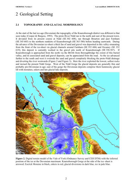
At the start <strong>of</strong> the last ice-age (Devensian) the topography <strong>of</strong> the <strong>Knaresborough</strong> district was different to that<br />
seen today (Cooper & Burgess, 1993). <strong>The</strong> proto River Nidd ran to the north and east <strong>of</strong> the present town.<br />
It deviated from its present course at Nidd (SE 302 608), ran through Brearton and past Farnham<br />
(SE 345 605) to the northern outskirts <strong>of</strong> <strong>Knaresborough</strong> (SE 363 580) before heading eastwards. During<br />
the advance <strong>of</strong> the Devensian ice-sheet a thick fan <strong>of</strong> sand and gravel was deposited in this valley emanating<br />
from the front <strong>of</strong> the ice-sheet via glacial channels around Farnham (SE 352 606) and Occaney (SE 352<br />
619); this deposit is currently worked in the gravel pits north <strong>of</strong> <strong>Knaresborough</strong> (SE 356 587). If<br />
<strong>Knaresborough</strong> is approached from the north via the B6166 from Boroughbridge the extent <strong>of</strong> this buried<br />
valley, and its associated sand and gravel deposits, can be appreciated from the road. As the ice advanced<br />
further to the south and west it overrode the sand and gravel completely blocking the proto-Nidd drainage<br />
and diverting the river westwards (Figure 2 and Figure 3). Here the river exploited the lowest, s<strong>of</strong>test rocks<br />
and incised the present Nidd <strong>Gorge</strong>. West <strong>of</strong> the Nidd <strong>Gorge</strong> the glacial deposits are generally thin and<br />
probably pre-Devensian in age; east <strong>of</strong> the gorge the Devensian deposits comprise thick hummocky glacial<br />
till with moraines, eskers and late glacial lake deposits.<br />
Figure 2. Digital terrain model <strong>of</strong> the Vale <strong>of</strong> York (Ordnance Survey and CEH DTM) with the inferred<br />
position <strong>of</strong> the ice at the Devensian maximum. <strong>Knaresborough</strong> <strong>Gorge</strong> at the side <strong>of</strong> the ice–sheet is<br />
arrowed. Escrick Moraine in black, eskers in red, glacial diversions in dark blue, ice in pale blue.<br />
2


