

The Geology of Knaresborough Gorge - NERC Open Research ...
The Geology of Knaresborough Gorge - NERC Open Research ...
The Geology of Knaresborough Gorge - NERC Open Research ...

You also want an ePaper? Increase the reach of your titles
YUMPU automatically turns print PDFs into web optimized ePapers that Google loves.
Denys Smith Memorial Trip: <strong>The</strong><br />
<strong>Geology</strong> <strong>of</strong> <strong>Knaresborough</strong> <strong>Gorge</strong><br />
- YGS 1st June 2008<br />
<strong>Geology</strong> Programme<br />
<strong>Open</strong> Report OR/08/044
<strong>The</strong> National Grid and other<br />
Ordnance Survey data are used<br />
with the permission <strong>of</strong> the<br />
Controller <strong>of</strong> Her Majesty’s<br />
Stationery Office.<br />
Licence No: 100017897/ 2008.<br />
Keywords <strong>Knaresborough</strong>,<br />
Permian, Cadeby Formation,<br />
dolomite, Carboniferous,<br />
unconformity.<br />
National Grid Reference<br />
SW corner 434313,455375<br />
NE corner 436412,457629<br />
Map<br />
Sheet 62, 1:50 000 scale,<br />
Harrogate<br />
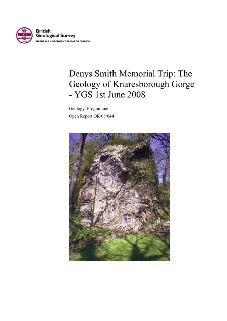
Front cover <strong>Knaresborough</strong>. (SE<br />
351 564) Chapel <strong>of</strong> Our Lady <strong>of</strong><br />
the Crag hewn from the Cadeby<br />
Formation, Sprotbrough Member<br />
dolomite <strong>of</strong> large-scale (5-18 m.<br />
sets) <strong>of</strong> cross-bedded oolite.<br />
Bibliographical reference<br />
COOPER, A.H.. 2008. Denys<br />
Smith Memorial Trip: <strong>The</strong><br />
<strong>Geology</strong> <strong>of</strong> <strong>Knaresborough</strong><br />
<strong>Gorge</strong> – YGS 1 st June 2008.<br />
British Geological Survey <strong>Open</strong><br />
Report, OR/08/044. 18pp.<br />
Copyright in materials derived<br />
from the British Geological<br />
Survey’s work is owned by the<br />
Natural Environment <strong>Research</strong><br />
Council (<strong>NERC</strong>) and/or the<br />
authority that commissioned the<br />
work. You may not copy or adapt<br />
this publication without first<br />
obtaining permission. Contact the<br />
BGS Intellectual Property Rights<br />
Section, British Geological<br />
Survey, Keyworth,<br />
e-mail ipr@bgs.ac.uk. You may<br />
quote extracts <strong>of</strong> a reasonable<br />
length without prior permission,<br />
provided a full acknowledgement<br />
is given <strong>of</strong> the source <strong>of</strong> the<br />
extract.<br />
Maps and diagrams in this report<br />
use topography based on<br />
Ordnance Survey mapping.<br />
© <strong>NERC</strong> 2008. All rights reserved<br />
BRITISH GEOLOGICAL SURVEY<br />
GEOLOGY PROGRAMME<br />
OPEN REPORT OR/08/044<br />
Denys Smith Memorial Trip: <strong>The</strong><br />
<strong>Geology</strong> <strong>of</strong> <strong>Knaresborough</strong> <strong>Gorge</strong><br />
- YGS 1st June 2008<br />
A H Cooper<br />
Keyworth, Nottingham British Geological Survey 2008
BRITISH GEOLOGICAL SURVEY<br />
<strong>The</strong> full range <strong>of</strong> our publications is available from BGS shops at<br />
Nottingham, Edinburgh, London and Cardiff (Welsh publications<br />
only) see contact details below or shop online at<br />
www.geologyshop.com<br />
<strong>The</strong> London Information Office also maintains a reference<br />
collection <strong>of</strong> BGS publications, including maps, for consultation.<br />
We publish an annual catalogue <strong>of</strong> our maps and other<br />
publications; this catalogue is available online or from any <strong>of</strong> the<br />
BGS shops.<br />
<strong>The</strong> British Geological Survey carries out the geological survey <strong>of</strong><br />
Great Britain and Northern Ireland (the latter as an agency<br />
service for the government <strong>of</strong> Northern Ireland), and <strong>of</strong> the<br />
surrounding continental shelf, as well as basic research projects.<br />
It also undertakes programmes <strong>of</strong> technical aid in geology in<br />
developing countries.<br />
<strong>The</strong> British Geological Survey is a component body <strong>of</strong> the Natural<br />
Environment <strong>Research</strong> Council.<br />
British Geological Survey <strong>of</strong>fices<br />
BGS Central Enquiries Desk<br />
Tel 0115 936 3143 Fax 0115 936 3276<br />
email enquiries@bgs.ac.uk<br />
Kingsley Dunham Centre, Keyworth, Nottingham NG12 5GG<br />
Tel 0115 936 3241 Fax 0115 936 3488<br />
email sales@bgs.ac.uk<br />
Murchison House, West Mains Road, Edinburgh EH9 3LA<br />
Tel 0131 667 1000 Fax 0131 668 2683<br />
email scotsales@bgs.ac.uk<br />
London Information Office at the Natural History Museum<br />
(Earth Galleries), Exhibition Road, South Kensington, London<br />
SW7 2DE<br />
Tel 020 7589 4090 Fax 020 7584 8270<br />
Tel 020 7942 5344/45 email bgslondon@bgs.ac.uk<br />
Columbus House, Greenmeadow Springs, Tongwynlais,<br />
Cardiff CF15 7NE<br />
Tel 029 2052 1962 Fax 029 2052 1963<br />
Forde House, Park Five Business Centre, Harrier Way,<br />
Sowton EX2 7HU<br />
Tel 01392 445271 Fax 01392 445371<br />
Maclean Building, Crowmarsh Gifford, Wallingford<br />
OX10 8BB<br />
Tel 01491 838800 Fax 01491 692345<br />
Geological Survey <strong>of</strong> Northern Ireland, Colby House,<br />
Stranmillis Court, Belfast BT9 5BF<br />
Tel 028 9038 8462 Fax 028 9038 8461<br />
www.bgs.ac.uk/gsni/<br />
Parent Body<br />
Natural Environment <strong>Research</strong> Council, Polaris House,<br />
North Star Avenue, Swindon SN2 1EU<br />
Tel 01793 411500 Fax 01793 411501<br />
www.nerc.ac.uk<br />
Website www.bgs.ac.uk<br />
Shop online at www.geologyshop.com
OR/08/044; Version 1 Last modified: 2008/05/30 10:56<br />
Foreword<br />
This field guide is presented as a memorial to Dr Denys Smith formerly <strong>of</strong> the British Geological<br />
Survey (BGS). It is based on the Yorkshire Geological Society field guide by Cooper (1994 &<br />
2006) with additions from the Harrogate Memoir (Cooper & Burgess, 1993).<br />
Contents<br />
Foreword.............................................................................................. i<br />
Contents................................................................................................ i<br />
Summary............................................................................................ iii<br />
1 Denys B. Smith, 1929-2007– Permian Geologist .......................1<br />
2 Geological Setting.........................................................................2<br />
2.1 Topography and glacial morphology....................................2<br />
2.2 Bedrock <strong>Geology</strong> <strong>of</strong> the <strong>Knaresborough</strong> area ......................4<br />
3 Excursion Details..........................................................................5<br />
References ..........................................................................................11<br />
i
OR/08/044; Version 1 Last modified: 2008/05/30 10:56<br />
FIGURES<br />
Figure 1 Denys Smith leading a field trip and demonstrating collapse breccia formation due to<br />
evaporite dissolution at Marsden Bay, Co Durham in 1984 to mark his retirement from the<br />
British Geological Survey. .................................................................................................... 1<br />
Figure 2. Digital terrain model <strong>of</strong> the Vale <strong>of</strong> York (Ordnance Survey and CEH DTM) with the<br />
inferred position <strong>of</strong> the ice at the Devensian maximum. <strong>Knaresborough</strong> <strong>Gorge</strong> at the side <strong>of</strong><br />
the ice–sheet is arrowed. Escrick Moraine in black, eskers in red, glacial diversions in dark<br />
blue, ice in pale blue.............................................................................................................. 2<br />
Figure 3. <strong>The</strong> glacial geology <strong>of</strong> <strong>Knaresborough</strong> <strong>Gorge</strong> at the Devensian glacial maximum, from<br />
Cooper and Burgess 1993, Figure 26. ................................................................................... 3<br />
Figure 4. Extract from British Geological Survey 1:50,000 scale geological map 62 (Harrogate –<br />
Solid & Drift) showing the geology <strong>of</strong> the <strong>Knaresborough</strong> <strong>Gorge</strong> area................................ 5<br />
Figure 5. Geological map <strong>of</strong> <strong>Knaresborough</strong> <strong>Gorge</strong> and cross-section through the Carboniferous<br />
and Permian sequence. Showing the Cadeby Formation oolite bank thinning to the west (it<br />
also thins to the north and south). <strong>The</strong> Cadeby Formation is overlapped by the Edlington<br />
Formation and the Brotherton Formation which rest unconformably on the upstanding<br />
Carboniferous strata <strong>of</strong> the Harrogate Anticline. <strong>The</strong> localities visited are numbered; those<br />
numbered 14, 15 and 16 will only be visited if there is time. ............................................... 6<br />
Figure 6. Abbey Crags, <strong>Knaresborough</strong>. <strong>The</strong> Carboniferous Permian unconformity at Abbey<br />
Crags, <strong>Knaresborough</strong>. Large-scale cross-bedded oolitic limestones <strong>of</strong> the Cadeby Formation<br />
– Sprotbrough Member (Lower Magnesian Limestone - Upper Subdivision) rest<br />
unconformably upon a buried hill <strong>of</strong> slightly reddened Upper Plompton Grit (Namurian).. 8<br />
Figure 7. SW <strong>of</strong> Grimbald Bridge, <strong>Knaresborough</strong>. Saint Robert's Cave, <strong>Knaresborough</strong>. <strong>The</strong><br />
cave believed to be the ancient dwelling place <strong>of</strong> St. Robert has been cut into the crossbedded<br />
and shelly, oolitic dolomites <strong>of</strong> the Cadeby Formation. <strong>The</strong> steps and foundations<br />
belong to another dwelling built in front <strong>of</strong> the cave. ........................................................... 9<br />
Figure 8. Generalised isopachyte map for the Cadeby Formation in the Harrogate district (Figure<br />
13 from Cooper and Burgess, 1993)...................................................................................... 10<br />
TABLES<br />
Table 1. <strong>The</strong> Permian sequence in the <strong>Knaresborough</strong> area ........................................................ 4<br />
Table 2. Chemistry <strong>of</strong> mineral water from the Dropping Well, <strong>Knaresborough</strong>; composition in<br />
mg/l. Date 1896 (recalculated from Fox-Strangways, 1908; partly after Edmunds et al.,<br />
1969)...................................................................................................................................... 7<br />
ii
OR/08/044; Version 1 Last modified: 2008/05/30 10:56<br />
Summary<br />
This guide is dedicated to Dr Denys Smith, expert on the Permian rocks <strong>of</strong> Britain and Europe.<br />
<strong>The</strong> field excursion illustrates the Permian and Quaternary geology <strong>of</strong> <strong>Knaresborough</strong> <strong>Gorge</strong>.<br />
<strong>The</strong> <strong>Gorge</strong> is a marginal glacial feature cut at the edge <strong>of</strong> the Devensian Ice sheet during the last<br />
Ice-Age. <strong>The</strong> River Nidd has cut down through the Permian and Carboniferous sequence. <strong>The</strong><br />
Permo-Carboniferous unconformity is exposed revealing a buried relief <strong>of</strong> low hills. <strong>The</strong><br />
Permian Cadeby Formation dolomites above the unconformity show massive subaqueous dune<br />
bedding and traces <strong>of</strong> ooids indicative <strong>of</strong> formation in a Bahamas Banks environment. Tufa-rich<br />
spring activity on the west side <strong>of</strong> the gorge has resulted in the formation <strong>of</strong> a large tufa screen<br />
with a small cave behind where it has partly collapsed; this is Mother Shipton’s Cave.<br />
iii
OR/08/044; Version 1 Last modified: 2008/05/30 10:56<br />
1 Denys B. Smith, 1929-2007– Permian Geologist<br />
For more than four decades Dr Denys Smith and Permian geology were synonymous. His name<br />
graces more than 60 eminent publications about Permian geology and he chaired important<br />
working groups on the Permian rocks. His enthusiasm for geology and the Permian in particular<br />
were illustrated by his roles as both president <strong>of</strong> the Leeds Geological Association and later as<br />
president <strong>of</strong> the Yorkshire Geological Society. His presidency <strong>of</strong> the YGS culminated with his<br />
presidential address on “<strong>The</strong> Late Permian palaeogeography <strong>of</strong> north-east England (Smith, 1986)<br />
this and later books drew together his vast knowledge <strong>of</strong> the Permian rocks and the Zechstein<br />
deposits in particular. His merit in the British Geological Survey was rewarded by his senior post<br />
and his geological <strong>of</strong> maps and memoirs will be consulted for centuries to come. Denys enthused<br />
students and staff who worked alongside him. John Kaldi (now a pr<strong>of</strong>essor in Australia) did his<br />
PhD jointly supervised by Denys on the sedimentology <strong>of</strong> the Permian rocks, concentrating on<br />
<strong>Knaresborough</strong> <strong>Gorge</strong>; this trip examines some <strong>of</strong> the exposures he studied. As leader <strong>of</strong> this trip<br />
it was my privilege to have worked under Denys when he was in charge <strong>of</strong> the British Geological<br />
Survey <strong>of</strong>fice in Newcastle. He presented me with copies <strong>of</strong> the majority <strong>of</strong> his papers and I<br />
consult them constantly. My understanding <strong>of</strong> the Permian rocks and the interpretation <strong>of</strong> much<br />
<strong>of</strong> the <strong>Knaresborough</strong> district would not have been possible without his considerable help. His<br />
publications are his lasting memorial.<br />
Figure 1 Denys Smith leading a field trip and demonstrating collapse breccia formation<br />
due to evaporite dissolution at Marsden Bay, Co Durham in 1984 to mark his retirement<br />
from the British Geological Survey.<br />
1
OR/08/044; Version 1 Last modified: 2008/05/30 10:56<br />
2 Geological Setting<br />
2.1 TOPOGRAPHY AND GLACIAL MORPHOLOGY<br />
At the start <strong>of</strong> the last ice-age (Devensian) the topography <strong>of</strong> the <strong>Knaresborough</strong> district was different to that<br />
seen today (Cooper & Burgess, 1993). <strong>The</strong> proto River Nidd ran to the north and east <strong>of</strong> the present town.<br />
It deviated from its present course at Nidd (SE 302 608), ran through Brearton and past Farnham<br />
(SE 345 605) to the northern outskirts <strong>of</strong> <strong>Knaresborough</strong> (SE 363 580) before heading eastwards. During<br />
the advance <strong>of</strong> the Devensian ice-sheet a thick fan <strong>of</strong> sand and gravel was deposited in this valley emanating<br />
from the front <strong>of</strong> the ice-sheet via glacial channels around Farnham (SE 352 606) and Occaney (SE 352<br />
619); this deposit is currently worked in the gravel pits north <strong>of</strong> <strong>Knaresborough</strong> (SE 356 587). If<br />
<strong>Knaresborough</strong> is approached from the north via the B6166 from Boroughbridge the extent <strong>of</strong> this buried<br />
valley, and its associated sand and gravel deposits, can be appreciated from the road. As the ice advanced<br />
further to the south and west it overrode the sand and gravel completely blocking the proto-Nidd drainage<br />
and diverting the river westwards (Figure 2 and Figure 3). Here the river exploited the lowest, s<strong>of</strong>test rocks<br />
and incised the present Nidd <strong>Gorge</strong>. West <strong>of</strong> the Nidd <strong>Gorge</strong> the glacial deposits are generally thin and<br />
probably pre-Devensian in age; east <strong>of</strong> the gorge the Devensian deposits comprise thick hummocky glacial<br />
till with moraines, eskers and late glacial lake deposits.<br />
Figure 2. Digital terrain model <strong>of</strong> the Vale <strong>of</strong> York (Ordnance Survey and CEH DTM) with the inferred<br />
position <strong>of</strong> the ice at the Devensian maximum. <strong>Knaresborough</strong> <strong>Gorge</strong> at the side <strong>of</strong> the ice–sheet is<br />
arrowed. Escrick Moraine in black, eskers in red, glacial diversions in dark blue, ice in pale blue.<br />
2
OR/08/044; Version 1 Last modified: 2008/05/30 10:56<br />
Figure 3. <strong>The</strong> glacial geology <strong>of</strong> <strong>Knaresborough</strong> <strong>Gorge</strong> at the Devensian glacial maximum, from Cooper<br />
and Burgess 1993, Figure 26.<br />
3
OR/08/044; Version 1 Last modified: 2008/05/30 10:56<br />
2.2 BEDROCK GEOLOGY OF THE KNARESBOROUGH AREA<br />
<strong>The</strong> solid rocks exposed in <strong>Knaresborough</strong> <strong>Gorge</strong> are <strong>of</strong> Carboniferous (Namurian) and Upper Permian age<br />
(Cooper & Burgess, 1993). Here the Permian strata overlap onto and submerge a surface <strong>of</strong> irregular relief<br />
eroded in the underlying Carboniferous sandstones and shales. <strong>The</strong> exposed Carboniferous sequence<br />
extends upwards from the Lower Follifoot Grit to the Lower Plompton Grit. At the northern end <strong>of</strong><br />
<strong>Knaresborough</strong> the Carboniferous rocks are folded around the nose <strong>of</strong> the Harrogate Anticline and dip at up<br />
to 27 degrees to the east and south-east (Figure 4). This anticline was formed during the Hercynian<br />
Orogeny prior to the Upper Permian deposition.<br />
<strong>The</strong> overlying Permian strata (Table 1) dip gently eastwards and rest unconformably on the Carboniferous<br />
rocks (cross-section in Figure 5). <strong>The</strong> lowest Permian rocks seen here are the Cadeby Formation (formerly<br />
Lower Magnesian Limestone). This formation is over 40m thick and subdivided into two members the<br />
lower one is the Wetherby Member (formerly Lower Subdivision) and the upper one the Sprotbrough<br />
Member (formerly Upper Subdivision). <strong>The</strong> Cadeby Formation (Sprotbrough Member) forms the ridge on<br />
which <strong>Knaresborough</strong> is built. <strong>The</strong> ridge consists largely <strong>of</strong> cross-bedded oolites and is capped by a small<br />
outlier <strong>of</strong> Edlington Formation (formerly Middle Marl). <strong>The</strong> <strong>Knaresborough</strong> ridge appears to be a primary<br />
depositional feature, for the limestone thins away from it in all directions and depositional dips (Kaldi,<br />
1980; giving the palaeocurrent information on Figure 5) mimic the form <strong>of</strong> the ridge. <strong>The</strong> thinning <strong>of</strong> the<br />
formation is best illustrated north-west <strong>of</strong> the town centre, near Conyngham Hall, where it thins to 1-3m <strong>of</strong><br />
even-bedded, sandy dolomite; the westward thinning is illustrated by the cross-section in Figure 5. <strong>The</strong><br />
overlying Edlington Formation comprises red-brown calcareous mudstone with some gypsum and is<br />
generally poorly exposed. It overlaps the Cadeby Formation both northwards and westwards to rest directly<br />
on the Carboniferous rocks. <strong>The</strong> Edlington Formation is in turn overlapped by the Brotherton Formation<br />
(formerly Upper Magnesian Limestone), a sequence <strong>of</strong> dolomitic limestone 5-15m thick, which rests<br />
directly on Carboniferous rocks at Scriven (SE 345 585) and Rudfarlington (SE 342 543).<br />
Formation and<br />
Members<br />
Old Name Main Lithology Local<br />
thickness<br />
(metres)<br />
Roxby Formation Upper Marl Mudstone with gypsum 10-15<br />
Brotherton Formation Upper Magnesian Limestone Dolomitic limestone 5-15<br />
Edlington Formation Middle Marl Calcareous mudstone with<br />
gypsum<br />
Cadeby Formation:<br />
Sprotbrough Mem.<br />
Wetherby Mem.<br />
Lower Magnesian Limestone:<br />
Upper Subdivision<br />
Lower Subdivision<br />
Table 1. <strong>The</strong> Permian sequence in the <strong>Knaresborough</strong> area<br />
4<br />
0-20<br />
Dolomite 0-40
OR/08/044; Version 1 Last modified: 2008/05/30 10:56<br />
Figure 4. Extract from British Geological Survey 1:50,000 scale geological map 62 (Harrogate – Solid &<br />
Drift) showing the geology <strong>of</strong> the <strong>Knaresborough</strong> <strong>Gorge</strong> area.<br />
3 Excursion Details<br />
Starting point. Riverside Car Park (SE 347 567)<br />
Location 1. (SE 348 569) From the car park and head northwards on the east side <strong>of</strong> the Nidd. Below the<br />
Castle the cliff section near the Weir, seen earlier from the opposite bank <strong>of</strong> the river exposes the<br />
unconformity at the base <strong>of</strong> the Cadeby Formation. <strong>The</strong> face is vertical about 27m high and not accessible.<br />
At road level 2-3m <strong>of</strong> weathered Addlethorpe Grit is exposed with a fossilised tree-trunk present below an<br />
overhang about 1 m above ground level. <strong>The</strong> remaining 27m <strong>of</strong> the cliff comprises a basal zone 6-7m thick<br />
<strong>of</strong> reddish-buff sandy dolomite overlain by about 17m <strong>of</strong> dolomite in large-scale cross-bedded units<br />
representing subaqueous dunes.<br />
Location 2. (SE 349 569). An energetic walk up the cliff path, just north <strong>of</strong> locality 1 to <strong>Knaresborough</strong><br />
Castle affords an opportunity to examine the Cadeby Formation at close hand and to visit the Castle. <strong>The</strong><br />
castle was originally Norman though all traces <strong>of</strong> that period have now disappeared; from 1371 it was a<br />
stronghold <strong>of</strong> the Duchy <strong>of</strong> Lancaster and used as a barracks. From the castle viewpoint the form <strong>of</strong> the<br />
<strong>Knaresborough</strong> <strong>Gorge</strong> glacial diversion channel can be appreciated; return to the riverside walk<br />
Location 3. (SE 3475 5685). Enter `Old Mother Shiptons' park (payment required) and proceed along the<br />
Long Walk to the Weir (SE 3475 5685); here Carboniferous sandstone (Addlethorpe Grit) is present in the<br />
river, and the sub-Permian unconformity is visible in the cliffs below the Walk. About 12 m <strong>of</strong> dolomite are<br />
exposed, overlain by red siltstones <strong>of</strong> the Edlington Formation with some slipped deposits <strong>of</strong> till. On the<br />
opposite bank <strong>of</strong> the river the Addlethorpe Grit and overlying Cadeby Formation form a sheer cliff, the<br />
unconformity at the base <strong>of</strong> the Permian sequence is clearly visible.<br />
5
OR/08/044; Version 1 Last modified: 2008/05/30 10:56<br />
Figure 5. Geological map <strong>of</strong> <strong>Knaresborough</strong> <strong>Gorge</strong> and cross-section through the Carboniferous and<br />
Permian sequence. Showing the Cadeby Formation oolite bank thinning to the west (it also thins to the<br />
north and south). <strong>The</strong> Cadeby Formation is overlapped by the Edlington Formation and the Brotherton<br />
Formation which rest unconformably on the upstanding Carboniferous strata <strong>of</strong> the Harrogate Anticline.<br />
<strong>The</strong> localities visited are numbered; those numbered 14, 15 and 16 will only be visited if there is time.<br />
Location 4. (SE 348 565). Proceed southwards to the Dropping Well. Here there are several magnificent<br />
tufa screens produced by the carbonate- and sulphate-rich waters <strong>of</strong> the spring. <strong>The</strong> Dropping Well spring<br />
emanates from the dolomite <strong>of</strong> the Cadeby Formation, but includes dissolved sulphates (Table 2) derived<br />
6
OR/08/044; Version 1 Last modified: 2008/05/30 10:56<br />
from the gypsum <strong>of</strong> the overlying Edlington Formation. <strong>The</strong> carbonate is readily deposited from the water<br />
forming the Dropping Well screens and petrifying objects placed in its path. `Mother Shipton's Cave' just<br />
north <strong>of</strong> the Dropping Well is situated below an ancient tufa screen. Near this well tradition says that the<br />
notorious sibyl <strong>of</strong> the North, Mother Shipton, was born in the year 1488. Leave `Old Mother Shipton's' by<br />
the exit at Low Bridge, cross to the east side <strong>of</strong> the river and walk south about 50m.<br />
Na<br />
mg/l<br />
15.5<br />
K 3.5<br />
Ca 633.2<br />
Mg 49.1<br />
HCO, 223.6<br />
SO, 1572.1<br />
Cl 27.1<br />
Sr 4.6<br />
Si 4.9<br />
Fe 1.1<br />
Mn 0.6<br />
Total determined mineralisation 2535.5<br />
Table 2. Chemistry <strong>of</strong> mineral water from the Dropping Well, <strong>Knaresborough</strong>; composition in mg/l.<br />
Date 1896 (recalculated from Fox-Strangways, 1908; partly after Edmunds et al., 1969).<br />
Location 5. (SE 351 565) At the entrance to Bunker's Hill Quarry (Caravan Park) massive, cross-bedded<br />
oolites <strong>of</strong> the Cadeby Formation are exposed in the cliff along to the `House in the rock' and the `Chapel <strong>of</strong><br />
Our Lady <strong>of</strong> the Crag', these may be visited upon payment <strong>of</strong> an entrance fee. <strong>The</strong> chapel was formerly<br />
known as St Robert's Chapel after the monk who built it (see Locality 9 for further details). To visit the<br />
rock faces in Bunker's Hill Quarry (SE 3515 5655) the caravan site owners must be asked for permission.<br />
Near the `Chapel <strong>of</strong> Our Lady <strong>of</strong> the Crag' the cliffs show rows <strong>of</strong> post holes from the ro<strong>of</strong>s <strong>of</strong> houses<br />
occupied by weavers up to about 1840. Hereabouts the rock faces show sections <strong>of</strong> oolitic dolomite which<br />
occurs in massive cross-bedded units with sets up to 18 m high; these belong to the Sprotbrough Member <strong>of</strong><br />
the Cadeby Formation. <strong>The</strong>se units represent massive sub-aqueous oolite sand waves. <strong>The</strong>re is a general<br />
westward thinning <strong>of</strong> the sequence from here to Callcut (see cross-section in Figure 5).<br />
Location 6. (SE 355 539). Proceed southwards along the road to the south end <strong>of</strong> the garden <strong>of</strong> the last<br />
house (Amtree House) on the east <strong>of</strong> the road. Please keep out <strong>of</strong> the garden which is private. Here,<br />
looking up at the rock face to the east, the unconformity between the massive sand-wave facies <strong>of</strong> the<br />
Cadeby Formation and the underlying Upper Plompton Grit is exposed. <strong>The</strong> sandstone is reddened and<br />
takes the form <strong>of</strong> a rounded buried hill with an exposed relief <strong>of</strong> 8m and a width <strong>of</strong> 32m (Figure 6). <strong>The</strong><br />
overlying Cadeby Formation covers the buried hill with subconcentric drapes <strong>of</strong> beds 0.1-0.15m thick. On<br />
the flanks <strong>of</strong> the buried hill the they pass laterally into large-scale cross-bedding on a scale <strong>of</strong> 1-10m. <strong>The</strong><br />
Cadeby Formation here comprises fine-grained crystalline to granular dolomite with sporadic poorly<br />
preserved ooliths.<br />
7
OR/08/044; Version 1 Last modified: 2008/05/30 10:56<br />
Figure 6. Abbey Crags, <strong>Knaresborough</strong>. <strong>The</strong> Carboniferous Permian unconformity at Abbey Crags,<br />
<strong>Knaresborough</strong>. Large-scale cross-bedded oolitic limestones <strong>of</strong> the Cadeby Formation – Sprotbrough<br />
Member (Lower Magnesian Limestone - Upper Subdivision) rest unconformably upon a buried hill <strong>of</strong><br />
slightly reddened Upper Plompton Grit (Namurian).<br />
Location 7. (SE 357 557). Continue southwards to the car turning point. North-east <strong>of</strong> here the<br />
unconformity at the base <strong>of</strong> the Cadeby Formation dips down into a buried valley, but reappears in the<br />
quarry east <strong>of</strong> the road. Here 3.6m <strong>of</strong> Carboniferous sandstone (Upper Plompton Grit) is present beneath<br />
13.5m <strong>of</strong> Cadeby Formation. <strong>The</strong> sandstone is very coarse to granule-grained, feldspathic, with quartz<br />
pebbles, and occurs in very thick cross-bedded units; the rock is reddened and weathered. At the base <strong>of</strong> the<br />
overlying limestone there is a thin impersistent bed (0-0.1m) <strong>of</strong> yellow, very coarse-grained sandstone with<br />
a dolomitic cement; it is not apparent whether this is part <strong>of</strong> the Carboniferous sequence, re-cemented with<br />
dolomite, or a very sandy bed at the base <strong>of</strong> the Permian. <strong>The</strong> overlying thin, medium and thick beds<br />
comprise dolomite with quartz grains in the lowest 0.5m or so.<br />
Location 8. (SE 357 557). About 60m south-east <strong>of</strong> Locality 7 the same unconformity rises to the top <strong>of</strong><br />
the old quarry in the private grounds east <strong>of</strong> the road. <strong>The</strong> section now exposes 10.5m <strong>of</strong> Carboniferous<br />
sandstone overlain by 4m <strong>of</strong> dolomite. This shows that locally the relief on the unconformity is a least 8m<br />
Location 9. (SE 361 570). Continue along the riverside road to the NNE for about 500m where St Robert's<br />
Cave (Figure 7) is situated in the river bank below the road; entry is made through a gap in the wall and a<br />
flight <strong>of</strong> steps. This cave was the former abode <strong>of</strong> the pious monk Robert Flower <strong>of</strong> York from Fountains<br />
Abbey, AD 1160-1218. He took refuge in the cave and turned another cave into St Robert's Chapel<br />
(Locality 5). <strong>The</strong> cave also gained notoriety as the scene in 1745 <strong>of</strong> the murder <strong>of</strong> Daniel Clark for which<br />
crime Eugene Aram, a scholar <strong>of</strong> considerable ability, was hanged at York in 1759. At St Robert's Cave<br />
thin sub-horizontal beds <strong>of</strong> cross-bedded, oolitic dolomite are exposed with a channel structure to the south<br />
<strong>of</strong> the cave entrance. <strong>The</strong>se beds are sparsely fossiliferous and probably represent the Wetherby Member<br />
(lower subdivision) <strong>of</strong> the Cadeby Formation. <strong>The</strong> member must, however, wedge out rapidly southwards<br />
8
OR/08/044; Version 1 Last modified: 2008/05/30 10:56<br />
because it is not present at Grimbald Crag (Locality 10, SE 361 558) only 300 m to the south. From St<br />
Robert's Cave proceed northwards along the road, cross the River Nidd by the Wetherby Road, and head<br />
southwards on the riverside footpath to Grimbald Crag.<br />
Figure 7. SW <strong>of</strong> Grimbald Bridge, <strong>Knaresborough</strong>. Saint Robert's Cave, <strong>Knaresborough</strong>. <strong>The</strong> cave<br />
believed to be the ancient dwelling place <strong>of</strong> St. Robert has been cut into the cross-bedded and shelly,<br />
oolitic dolomites <strong>of</strong> the Cadeby Formation. <strong>The</strong> steps and foundations belong to another dwelling built in<br />
front <strong>of</strong> the cave.<br />
Location 10. (SE 361 558). Grimbald Crag exposes a sequence similar to that found at Abbey Crags and<br />
reveals another hill in the pre-Permian topography. About 16 m <strong>of</strong> massive, cross-bedded dolomite rest<br />
unconformably on reddened Lower Plompton Grit with one footpath running along the unconformity. <strong>The</strong><br />
unconformity was formerly exposed overlain by about 2m <strong>of</strong> evenly bedded dolomitic limestone; then by<br />
massive cross-bedded units typical <strong>of</strong> the area (Dr Denys Smith, pers comm.). <strong>The</strong> unconformity is now<br />
obscured, but the lowest Permian beds seen contain abundant derived quartz grains. South <strong>of</strong> Grimbald<br />
Crag a fault, down-throwing to the south, brings the Brotherton Formation limestone outcrop against that <strong>of</strong><br />
the Lower Plompton Grit.<br />
Location 11. (SE 3567 5552). <strong>The</strong> Brotherton Formation limestone is best seen at the top <strong>of</strong> the bank west<br />
<strong>of</strong> Birkham Wood (SE 3567 5552). This exposure comprises 1.5m <strong>of</strong> white and pale grey, thin-bedded,<br />
porcellanous, dolomitic limestones which contains fossils. <strong>The</strong>se include small tube-like algal threads <strong>of</strong><br />
Calcinema permiana (King) Podemski which commonly occur in drifts and other concentrations, plus the<br />
bivalves Schizodus obscurus (J. Sowerby) and Liebea.<br />
Location 12. (SE356 556). 100m north <strong>of</strong> locality 11 the Grimbald Crag Fault crosses the River Nidd<br />
opposite the Priory and is marked by a prolific spring. At this locality the Brotherton Formation limestone<br />
and Roxby Formation (formerly called the Upper Marl) are thrown against the Cadeby Formation, the fault<br />
scarp forming a prominent feature which can be traced to the west.<br />
9
OR/08/044; Version 1 Last modified: 2008/05/30 10:56<br />
Location 13. (SE 352 560) North <strong>of</strong> the Grimbald Crag Fault Calcutt Cricket Ground occupies a quarry<br />
excavated in the Sprotbrough Member <strong>of</strong> the Cadeby Formation. East <strong>of</strong> the quarry the Lower Plompton<br />
Grit is exposed in the river bed while to the south and north the Edlington Formation overlies the dolomite<br />
<strong>of</strong> the Cadeby Formation. East <strong>of</strong> the Nidd, beneath <strong>Knaresborough</strong>, the Cadeby Formation is thick and its<br />
top rises to 75 m O.D., but at Calcutt it is thin and the top only rises to 53 m. As the regional dip <strong>of</strong> the<br />
Permian rocks is to the east, the westward thinning <strong>of</strong> the Cadeby Formation at this point is clearly<br />
illustrated (see Figure 8 and cross-section in Figure 5). Proceed along the riverside path to Low Bridge,<br />
Figure 8. Generalised isopachyte map for the Cadeby Formation in the Harrogate district (Figure 13 from<br />
Cooper and Burgess, 1993).<br />
Additional localities included in the YGS trip (Cooper, 1994):<br />
Location 14. (SE 3425 5742). Continue upstream past the High Bridge to Conyngham Hall Farm,where the<br />
track crosses the river again. Fifty metres to the east, in the wooded area below Conyngham Hall, the<br />
attenuated Cadeby Formation (only 1.2m thick) is seen resting on weathered purple-brown Carboniferous<br />
siltstones, and overlain by the Edlington Formation. <strong>The</strong> exposed Edlington Formation comprises 2.6m <strong>of</strong><br />
red-brown mudstone and sandstone; it includes sandy and micaceous detritus derived from Carboniferous<br />
sandstones similar to those exposed 100 m to the east, where the Edlington Formation rests directly on<br />
Carboniferous strata. <strong>The</strong> N-S cross-section through here is similar to the E-W cross-section shown in<br />
Figure 5.<br />
10
OR/08/044; Version 1 Last modified: 2008/05/30 10:56<br />
Location 15. (SE 342 575) Near Conyngham Hall Farm the Upper Follifoot Grit crosses the river, forming<br />
the foundations <strong>of</strong> the bridge. <strong>The</strong> sandstone dips to the east at 27 degrees and comprises some 7m <strong>of</strong> fine<br />
to medium-grained sandstone with subordinate siltstone partings and a thick bed <strong>of</strong> siliceous ganister with<br />
rootlets near the middle <strong>of</strong> the unit. <strong>The</strong> Carboniferous rocks here, and at locality 16, dip steeply eastwards<br />
around the nose <strong>of</strong> the Harrogate Anticline. <strong>The</strong> resistant sandstone units form small escarpments projecting<br />
above the general level <strong>of</strong> the sub-Permian unconformity, and the basal Permian sedimentary rocks are<br />
banked against them.<br />
Location 16. (SE 3413 5722) Follow the river southwards to Foolish Wood where in an old quarry the<br />
Upper Follifoot Grit dips south-west at 27 degrees. At the back <strong>of</strong> the quarry, sub-horizontal dolomite,<br />
0.5 m thick, <strong>of</strong> the Cadeby Formation rests with a basal conglomerate <strong>of</strong> local material on an irregular<br />
sandstone surface, and is overlain by red siltstone. <strong>The</strong> sandstone apparently formed a ridge on the sea-floor<br />
prior to the deposition <strong>of</strong> the Cadeby Formation. Only a few metres to the north <strong>of</strong> the quarry, where the<br />
dolomite rests on siltstones underlying the Upper Follifoot Grit it thickens to 3 m, forming an escarpment<br />
from which large blocks have slipped down to the river bank.<br />
References<br />
Most <strong>of</strong> the references listed below are held in the Library <strong>of</strong> the British Geological Survey at Keyworth,<br />
Nottingham. Copies <strong>of</strong> the references may be purchased from the Library subject to the current copyright<br />
legislation.<br />
COOPER, A.H. 1994 and 2006. <strong>The</strong> Permian and Carboniferous rocks <strong>of</strong> <strong>Knaresborough</strong>. 124-132 in<br />
Scrutton, C. Yorkshire rocks and landscape. Yorkshire Geological Society, Ellenbank Press.<br />
COOPER, A H and BURGESS, I C. 1993. <strong>Geology</strong> <strong>of</strong> the country around Harrogate. Memoir <strong>of</strong> the British<br />
Geological Survey, Sheet 62 (England and Wales).<br />
EDWARDS, W M, TAYLOR, B J, and DOWNING, R A. 1969. Mineral and thermal waters in the<br />
United Kingdom. Proceedings <strong>of</strong> the XXXII International Geological Congress, Vol. 18, 139-158.<br />
FOX-STRANGWAYS, C. 1908. <strong>The</strong> geology <strong>of</strong> the country north and east <strong>of</strong> Harrogate (2nd edition).<br />
Memoir <strong>of</strong> the Geological Survey, Sheet 62 (England and Wales). 100pp.<br />
KALDI, J G. 1980. Aspects <strong>of</strong> the sedimentology <strong>of</strong> the Lower Magnesian Limestone (Permian) <strong>of</strong> Eastern<br />
England. Unpublished PhD thesis, University <strong>of</strong> Cambridge.<br />
SMITH, D.B. 1989. <strong>The</strong> late Permian palaeogeography <strong>of</strong> north-east England. Proceedings <strong>of</strong> the Yorkshire<br />
Geological Society.Vol. 47, 285-312.<br />
11


