Emini
Emini
Emini

Create successful ePaper yourself
Turn your PDF publications into a flip-book with our unique Google optimized e-Paper software.
CHAPTER<br />
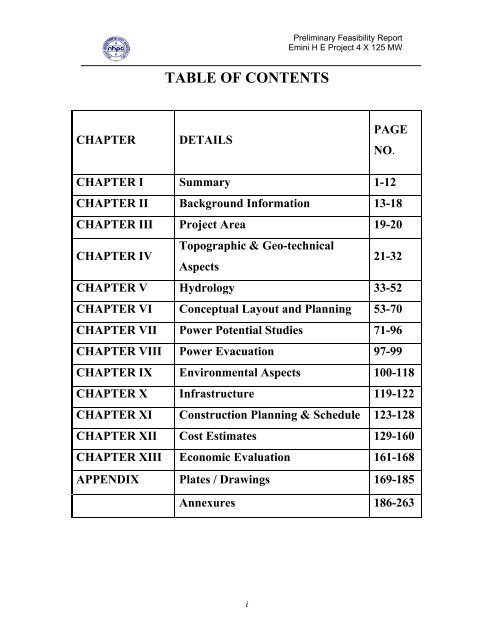
TABLE OF CONTENTS<br />
DETAILS<br />
i<br />
Preliminary Feasibility Report<br />
<strong>Emini</strong> H E Project 4 X 125 MW<br />
PAGE<br />
NO.<br />
CHAPTER I Summary 1-12<br />
CHAPTER II Background Information 13-18<br />
CHAPTER III Project Area 19-20<br />
CHAPTER IV<br />
Topographic & Geo-technical<br />
Aspects<br />
21-32<br />
CHAPTER V Hydrology 33-52<br />
CHAPTER VI Conceptual Layout and Planning 53-70<br />
CHAPTER VII Power Potential Studies 71-96<br />
CHAPTER VIII Power Evacuation 97-99<br />
CHAPTER IX Environmental Aspects 100-118<br />
CHAPTER X Infrastructure 119-122<br />
CHAPTER XI Construction Planning & Schedule 123-128<br />
CHAPTER XII Cost Estimates 129-160<br />
CHAPTER XIII Economic Evaluation 161-168<br />
APPENDIX Plates / Drawings 169-185<br />
Annexures 186-263
CHAPTER<br />
NO<br />
TABLE<br />
NO<br />
LIST OF TABLES<br />
ii<br />
Preliminary Feasibility Report<br />
<strong>Emini</strong> H E Project 4 X 125 MW<br />
TITLE PAGE<br />
NO<br />
II 2.1 Power Position of North Eastern<br />
Region<br />
16<br />
II 2.2 Power Position of All India 17<br />
V 5.1 Observed Temperature and<br />
Humidity at Hunli<br />
V 5.2 Observed Temperature and<br />
Humidity at Elopa<br />
V 5.3 Maximum Temperature at Anini 39<br />
V 5.4 Minimum Temperature at Anini 39<br />
V 5.5 Status of rain gauge data in<br />
Dibang Basin<br />
40<br />
V 5.6 Average Monthly Rainfall In Dibang<br />
Basin (mm)<br />
V 5.7 Rainfall Correction Factor 44<br />
V 5.8 Flood Computed by Various<br />
Methods<br />
49<br />
V 5.9 Average 10 daily discharge<br />
(Cumec) at Dam site<br />
VII 7.1 Discharge Data 76<br />
VII 7.2 90% Dependable Year Flow for<br />
Power Generation<br />
VII 7.3 Reservoir Operation Report 78<br />
VII 7.3A Availability of Units in 90%<br />
Dependable Year<br />
VII 7.4 Reservoir Operation Study 80<br />
37<br />
38<br />
43<br />
52<br />
77<br />
79
VII 7.5 Power Potential in 90%<br />
Dependable Year.<br />
iii<br />
Preliminary Feasibility Report<br />
<strong>Emini</strong> H E Project 4 X 125 MW<br />
VII 7.6-7.20 Reservoir Operation Study 82-96<br />
XIII 13.1 IDC Calculation at Present Day<br />
Cost<br />
XIII 13.2 Unit Cost of Energy at Bus Bar at<br />
Current Price Level<br />
81<br />
164<br />
165<br />
XIII 13.3 Energy Rate with Present Cost 166<br />
XIII 13.2A Unit Cost of Energy at Bus Bar at<br />
Current Price Level without Free<br />
Power to Home State<br />
XIII 13.3A Energy Rate with Present Cost<br />
without Free Power to Home State<br />
167<br />
168
Chapter<br />
No<br />
Plate<br />
No<br />
PLATES / DRAWINS<br />
iv<br />
Preliminary Feasibility Report<br />
<strong>Emini</strong> H E Project 4 X 125 MW<br />
Title Page No<br />
II 2.1 Vicinity Map 169<br />
II 2.2 Cascade Development in Mathun<br />
Basin<br />
IV 4.1 Geological Plan Of The Project<br />
Area<br />
IV 4.2 Tentative Geological Section<br />
V 5.1<br />
along Dam Axis<br />
Hydroelectric projects proposed<br />
in Dibang Valley<br />
V 5.2 Catchment Plan of <strong>Emini</strong> H.E<br />
Project<br />
170<br />
171<br />
172<br />
173<br />
174<br />
V 5.3 Area Capacity Curve 175<br />
VI 6.1 General Layout 176<br />
VI 6.2 General Layout of Longitudinal<br />
Section<br />
177<br />
VI 6.3 Layout Plan of Dam Area 178<br />
VI 6.4 Dam Upstream Elevation 179<br />
VI 6.5 Dam Cross Sections 180<br />
6.6 Water Conductor System<br />
Cross Section<br />
181<br />
VI 6.7 Layout Plan of Power House<br />
Area<br />
182<br />
VI 6.8 X Section of Power House 183<br />
VIII 8.1 Single Line Diagram 184<br />
VIII 8.2 Dibang Basin- Power Evacuation<br />
System<br />
184A<br />
XI 11.1 Construction Schedule 185
LIST OF ANNEXURE<br />
v<br />
Preliminary Feasibility Report<br />
<strong>Emini</strong> H E Project 4 X 125 MW<br />
CHAPTER ANNEXURE TITLE PAGE<br />
IV 4.1 Information received from<br />
Geological Survey of India on<br />
general geology of Project Area<br />
V 5.1 The observations received from<br />
CWC vide letter No 4/330/2003<br />
Hyd NE/336-37 dated<br />
21/10/2003 and reply of NHPC<br />
V 5.2 The observations received from<br />
CWC vide letter No 4/330/2003<br />
Hyd NE/357 dated 21/10/2003<br />
and reply of NHPC<br />
V 5.3 The observations received from<br />
CWC vide letter No 4/330/2003<br />
Hyd NE/56-57 dated 03/02/2004<br />
and reply of NHPC<br />
VI 6.1 Excerpts from CEA’s<br />
VI 6.2<br />
reassessment study report<br />
Record note of discussion with<br />
CEA regarding vetting of layout<br />
VI 6.3 Comments of CMDD<br />
Directorate, CWD and reply of<br />
NHPC<br />
VII 7.1 Summary Record of discussion<br />
with CEA regarding power<br />
potential studies.<br />
VII&VIII 8.1 Comments of SP&PA Division,<br />
CEA vide UO no 82/18/2003-<br />
SP&PA dated 23.10.03 and<br />
reply of NHPC.<br />
IX 9.1 Report from NRSA, Hyderabad<br />
on satellite remote sensing based<br />
inputs for initial environmental<br />
studies for Agoline H.E. project<br />
site<br />
NO<br />
186-193<br />
194-204<br />
205-210<br />
211-215<br />
216-218<br />
219-222<br />
223-226<br />
227-230<br />
231-246<br />
247-263
GLOSSARY<br />
CEA Central Electricity Authority<br />
D/S Downstream<br />
EL Elevation<br />
FRL Full Reservoir Level<br />
FSL Full Supply Level<br />
G & D Gauge & Discharge<br />
GSI Geological Survey of India<br />
Ha Hectare<br />
IDC Interest during Construction<br />
km Kilometre<br />
km 2<br />
Square kilometre<br />
KW Kilo Watt<br />
kwh Kilo Watt Hour<br />
LR Lower Reservoir<br />
LS Lump Sum<br />
A.P. Arunachal Pradesh<br />
M 3<br />
Cubic Metre<br />
M 3 /s Cubic Metre per second<br />
MDD Maximum Dry Density<br />
MDDL Minimum Draw Down Level<br />
mm Millimetre<br />
Mm 3<br />
Million cubic metre<br />
MSL Mean Sea Level<br />
MW Mega Watt<br />
MWL Maximum Water Level<br />
vi<br />
Preliminary Feasibility Report<br />
<strong>Emini</strong> H E Project 4 X 125 MW<br />
NHPC National Hydroelectric Power Corporation Ltd.<br />
o C Degree Celcious<br />
GREF General Reserve Engineering Force<br />
P.A.F Project Affected People<br />
U/S Upstream
vii<br />
Preliminary Feasibility Report<br />
<strong>Emini</strong> H E Project 4 X 125 MW<br />
I. Summary
viii<br />
Preliminary Feasibility Report<br />
<strong>Emini</strong> H E Project 4 X 125 MW<br />
II. Background<br />
Information
ix<br />
Preliminary Feasibility Report<br />
<strong>Emini</strong> H E Project 4 X 125 MW<br />
III. Project Area
x<br />
Preliminary Feasibility Report<br />
<strong>Emini</strong> H E Project 4 X 125 MW<br />
IV. Topographic &<br />
Geo-technical<br />
Aspect
xi<br />
Preliminary Feasibility Report<br />
<strong>Emini</strong> H E Project 4 X 125 MW<br />
V. Hydrology
xii<br />
Preliminary Feasibility Report<br />
<strong>Emini</strong> H E Project 4 X 125 MW<br />
VI. Conceptual<br />
Layout & Planning
xiii<br />
Preliminary Feasibility Report<br />
<strong>Emini</strong> H E Project 4 X 125 MW<br />
VII. Power Potential<br />
Studies
xiv<br />
Preliminary Feasibility Report<br />
<strong>Emini</strong> H E Project 4 X 125 MW<br />
VIII. Power<br />
Evacuation
xv<br />
Preliminary Feasibility Report<br />
<strong>Emini</strong> H E Project 4 X 125 MW<br />
IX. Environmental<br />
Aspects
xvi<br />
Preliminary Feasibility Report<br />
<strong>Emini</strong> H E Project 4 X 125 MW<br />
IX. Infrastructure
xvii<br />
Preliminary Feasibility Report<br />
<strong>Emini</strong> H E Project 4 X 125 MW<br />
XI. Construction<br />
Planning & Schedule
xviii<br />
Preliminary Feasibility Report<br />
<strong>Emini</strong> H E Project 4 X 125 MW<br />
XII. Cost Estimate
xix<br />
Preliminary Feasibility Report<br />
<strong>Emini</strong> H E Project 4 X 125 MW<br />
XIII. Economic<br />
Evaluation
1.1 INTRODUCTION<br />
CHAPTER - I<br />
SUMMARY<br />
1<br />
Preliminary Feasibility Report<br />
<strong>Emini</strong> HE Project 4 X 125 MW<br />
<strong>Emini</strong> H.E. Project is located in a remote area of Dibang valley<br />
district of Arunachal Pradesh. The project envisages utilisation of<br />
water of river Mathun or Adzon. Mathun is a tributary of Dri or<br />
Dibang river. Dibang river is the tributary of river Brahmaputra.<br />
To exploit hydro potential and to derive benefits of flood<br />
moderation, DPR of Dibang multipurpose project (3000 MW) is<br />
under preparation by Brahmaputra board in association with CWC/<br />
CEA . CEA has also identified ten number of schemes in Dibang<br />
basin in addition to Dibang Multi Purpose Project in their ranking<br />
studies. These ten additional projects in Dibang Basin (Arunachal<br />
Pradesh) are as a part of exercise for development of balance<br />
hydroelectric potential in the country and accorded priority for<br />
preparation of Preliminary Feasibility Report (PFR) so that these<br />
could be taken up for preparation of Detailed Project Report (DPR)<br />
and further development during the XI and XII Five Year Plans.<br />
The <strong>Emini</strong> project is one of the above ten schemes in Dibang basin.<br />
CEA’s reassessment study report envisaged construction of a<br />
diversion structure of a small height on the Mathun river at a site<br />
where the river bed level is +1200m and leading the water to a<br />
power house through a 6.5 km long channel. The scheme would<br />
utilise a gross head of 115 m and enable a firm power generation of<br />
39MW. With an optimum generating capacity 295MW, the scheme
2<br />
Preliminary Feasibility Report<br />
<strong>Emini</strong> HE Project 4 X 125 MW<br />
would enable energy generation of 1160 Gwh and 1333 Gwh<br />
respectively in 90% and 50% dependable years.<br />
Based on Topographical, Geological and Hydro meteorological<br />
studies of the area, a few modifications have been<br />
made in the layout of the project. The dam is proposed to<br />
be located downstream of confluence of Kanji rivulet with Mathun<br />
river at riverbed level of EL +1200 m. The power house is<br />
proposed with tail race bed level at EL+1118 m. Keeping in view<br />
of steep topography and river bend available, a Headrace tunnel of<br />
about 5 km in length has been proposed to be provided in place of<br />
the proposed open channel of 6.5 km length. Installed capacity of<br />
this project would be 500MW (4 X 125 MW) instead of 295 MW<br />
as indicated in reassessment studies of CEA.<br />
1.2 GENERAL PROJECT FEATURES<br />
The <strong>Emini</strong> HE Project envisages construction of: -<br />
> River diversion works comprising of one 12 m diameter<br />
horseshoe shaped diversion tunnel with u/s and d/s<br />
cofferdams.<br />
> 85 m high concrete gravity dam from deepest foundation level<br />
> To provide a gross storage of 47 Mcum at FRL of EL 1270 m<br />
and a gross storage of 34 Mcum at MDDL of EL 1260 m .<br />
> Spillway comprising of (a) low level orifice spillway - 5 nos<br />
of opening size 7 m X 10 m with crest elevation at EL 1230m<br />
and (b) crest type spillway - 2 nos of opening size 7.0 m X<br />
10.0m with crest elevation at EL 1260 m
3<br />
Preliminary Feasibility Report<br />
<strong>Emini</strong> HE Project 4 X 125 MW<br />
> 4 nos of Desilting chambers of length 350m (L) and size<br />
18 m (W)X 25 m (H) to remove silt particle of size 0.2mm<br />
and above.<br />
> 2 nos 5km long 8 m diameter horseshoe shaped headrace<br />
tunnel.<br />
> 2 nos 75 m high 25 m diameter surge shaft.<br />
> 2 nos 7.0 m diameter steel lined pressure shaft with vertical<br />
height 115 m.<br />
> An underground power house with an installation of 4 units of<br />
125 MW each having overall size 120 m (L) X 24 m (W) X<br />
45 m (H) .<br />
> 2 nos 8 m diameter horseshoe shaped tailrace tunnel to carry<br />
the power house release back to the river.<br />
1.3 SALIENT FEATURES<br />
1.3.1 LOCATION<br />
State : Arunachal Pradesh<br />
River : Adjon/ Mathun river<br />
Dam site : D/S of confluence of Kanji rivulet<br />
with Mathun river<br />
Nearest airport : Dibrugarh<br />
Nearest Railhead : Tinsukia<br />
1.3.2<br />
HYDROLOGY<br />
Catchment area : 2600sq.km.<br />
Location of catchment<br />
Latitude : 28 o 45'N, 29 o 30’N<br />
Longitude : 95 o 30'E, 96 o 10'E<br />
Average annual<br />
rainfall<br />
: 4023mm<br />
Formatted: Bullets and Numbering
4<br />
Preliminary Feasibility Report<br />
<strong>Emini</strong> HE Project 4 X 125 MW<br />
1.3.3 RESERVOIR<br />
Full reservoir level : 1270 m<br />
(FRL)<br />
Min.Draw Down Level 1260 m<br />
(MDDL)<br />
Gross storage<br />
-at FRL : 46.555 mcm<br />
-at MDDL :<br />
Area under<br />
34.060 mcm<br />
submergence at FRL : 166 ha<br />
1.3.4 DIVERSION TUNNEL<br />
Number : 1<br />
Size : 12 m<br />
Shape : Horse shoe<br />
Length : 700m<br />
Diversion discharge : 1600 cumec<br />
( assumed)<br />
U/s coffer dam : 25 m<br />
D/s coffer dam : 12 m<br />
1.3.5 DAM<br />
Type : Concrete Gravity<br />
Top elevation of dam : 1275 m<br />
Height of dam above : 85 m<br />
deepest foundation<br />
level<br />
Length of dam at top : 335 m<br />
River Bed level 1200 m<br />
1.3.6 SPILLWAY<br />
Design flood : 7000 Cumec<br />
Lower spillway<br />
Type : Orifice type<br />
Crest elevation : 1230m<br />
Number : 5<br />
Size of opening : 7 m x 10m
5<br />
Preliminary Feasibility Report<br />
<strong>Emini</strong> HE Project 4 X 125 MW<br />
Upper spillway<br />
Type : Crest type<br />
Crest elevation 1260 m<br />
Number : 2<br />
Size of opening : 7 m x 10 m<br />
Length of spillway : 105 m<br />
Energy dissipation<br />
:<br />
Ski jump with preformed<br />
plunge pool<br />
1.3.7 INTAKE<br />
Invert level : 1240 m<br />
Number : 2<br />
Size of gate opening : 7.9m x 9 m<br />
Trash rack : 19 x 20 m<br />
1.3.8 DESILTING CHAMBERS<br />
Number : 4<br />
Size : 18 m x 25 m<br />
Length : 350 m<br />
Design discharge : 135.6 each<br />
per chamber<br />
Particle size to be : 0.20 mm and above<br />
removed<br />
1.3.9 HEAD RACE TUNNEL<br />
Number : 2<br />
Size : 8 m<br />
Shape : Horse shoe<br />
Length : 5 km<br />
Design discharge<br />
per tunnel : 222cumec<br />
1.3.10 SURGE SHAFT<br />
Number : 2<br />
Size : 25 m dia<br />
Height 75 m<br />
1.3.11 PRESSURE SHAFT<br />
Number : 2<br />
Size : 7 m dia. steel lined<br />
Vertical height : 115 m
6<br />
Preliminary Feasibility Report<br />
<strong>Emini</strong> HE Project 4 X 125 MW<br />
1.3.12 POWER HOUSE<br />
Type : Underground<br />
Installed capacity : 500MW<br />
Number of units : 4 (125MW each)<br />
Power house cavern<br />
size<br />
: 120m(L)X24m(W)X45m(H)<br />
Type of turbine : Vertical Francis<br />
1.3.13 DRAFT TUBE GATE CUM TRANSFORMER CAVERN<br />
Cavern size 100m (L) X 20 m (W)X25m(H)<br />
Draft tube opening for : 11m X 5m with one 2 m wide<br />
each unit<br />
intermediate pier<br />
1.3.14 TAILRACE<br />
TUNNEL<br />
Number : 2<br />
Size : 8 m<br />
Shape : Horse shoe<br />
Length<br />
Design discharge per<br />
: 250 m<br />
tunnel<br />
:<br />
222 cumec<br />
River bed level 1118m<br />
Maximum TWL 1128 m<br />
1.3.15 POTHEAD YARD<br />
Size : 25m (W) X 60 m (L)<br />
1.3.16 POWER<br />
GENERATED<br />
Installed capacity : 500 MW<br />
Annual energy<br />
Generation in 90%<br />
dependable year : 1695.45 MU<br />
1.3.18 COST ESTIMATE & FINANCIAL ASPECT<br />
(Rs.Crores)<br />
Civil Works : 2246.39<br />
Electromechanical<br />
Works including<br />
: 492.82
transmission<br />
7<br />
Preliminary Feasibility Report<br />
<strong>Emini</strong> HE Project 4 X 125 MW<br />
Total (Hard Cost) : 2739.21<br />
Interest during<br />
construction<br />
: 327.99<br />
Grand total (including<br />
IDC)<br />
: 3067.20<br />
Tariff for first year<br />
With 12% free power<br />
to home state<br />
Without 12% free<br />
power to home state<br />
Levellised Tariff<br />
With 12% free power<br />
to home state<br />
Without 12% free<br />
power to home state<br />
1.4 STUDIES UNDERTAKEN<br />
:<br />
:<br />
:<br />
:<br />
Reconnaissance of the area for locating probable alternative<br />
sites of project component.<br />
Study of topoxraphic maps.<br />
Geological appraisal of the of the proposed project<br />
components.<br />
Study of regional geo-technical features / seimotectonic<br />
aspects.<br />
Power potential studies.<br />
Conceptual layout and project planning.<br />
3.99<br />
3.51<br />
3.24<br />
2.85
8<br />
Preliminary Feasibility Report<br />
<strong>Emini</strong> HE Project 4 X 125 MW<br />
Study of biotic environment, socio-economic environment<br />
for prediction of environmental impacts of the project.<br />
Water availability, design flood studies based on available<br />
meteorological/ hydrological data.<br />
Study of existing infrastructure.<br />
Cost benefit and Economic evaluation.<br />
1.5 RESULTS OF STUDIES AND INVESTIGATIONS: -<br />
1.5.1 GEOLOGY<br />
The Project area falls within the Diorite-Granodiorite-Granite<br />
complex of the Upper Dibang Valley. The granodiorite/diorite<br />
exposed in the area is medium to coarse grained, mesocratic,<br />
greenish-grey rock and consist of plagioclase, quartz, potash<br />
feldspar and several other mafic minerals (epidote, Biotite,<br />
amphibole, apatite, sphene, chlorite, etc.). Granodiorite grades into<br />
Granite with a gradual increase in quartz & K-feldspar content. It<br />
shows gneissocity in many areas. The rock is intruded by several<br />
quartz & pegmatite veins ranging in thickness from less than one<br />
meter to more than 10 meters.<br />
1.5.2 HYDROLOGY<br />
The river Mathun drains a catchment area of about 2600 sq.km. at<br />
the proposed dam site. The water availability for the project has<br />
been considered on the basis of 10-daily discharge series at Munli<br />
dam site for the period 1985-2001. The water availability at the<br />
<strong>Emini</strong> dam site has been derived from above data on the basis of<br />
catchment area proportion and applying an overall reduction factor
9<br />
Preliminary Feasibility Report<br />
<strong>Emini</strong> HE Project 4 X 125 MW<br />
of 15%. The computed inflow series worked out has been utilized<br />
for Power Potential Studies. The design flood has been assessed as<br />
7858 cumecs.<br />
1.5.3 POWER POTENTIAL STUDIES<br />
The computed inflow series for 16 years viz. 1985-86 to 2000-01<br />
has been considered in the assessment of a power benefits from the<br />
project. As per GOI notification for tariff the year 1994-95<br />
corresponds to 90% dependable year. An installation of 500 MW<br />
comprising 4 generating units of 125MW has been proposed. The<br />
energy availability from the project in a dependable and an average<br />
year has been summarized below :<br />
Particulars Dependable Year<br />
Annual Energy Generation<br />
Annual Energy Generation (GWh) 1695.45MU<br />
Annual Load Factor (%) 38.71%<br />
Generation during Lean Flow Season (Dec.-Feb.)<br />
Power Output (MWc) 118.19 MW<br />
Load Factor (%) 23.50%<br />
The design energy for tariff at 95% availability in a 90%<br />
dependable year has been worked out at 1695.45 GWh.<br />
A live storage of 12.50 mcum has been provided which would<br />
enable the station to operate as peaking station. The live storage is<br />
equivalent to 3917.19MWh which sufficient to operate the station<br />
for 7.8 hours.
1.5.4 POWER EVACUATION SYSTEM<br />
10<br />
Preliminary Feasibility Report<br />
<strong>Emini</strong> HE Project 4 X 125 MW<br />
The power generated from the project would be evacuated through<br />
220 kV, double circuit lines to a pooling station near Anini to feed<br />
into the Grid, which in turn connected, to National Grid.<br />
1.5.5 ENVIRONMENTAL ASPECT<br />
<strong>Emini</strong> H.E project is a run of the river scheme. The climate of the<br />
foot hills is tropical while in the mountains , temperature decreases<br />
rapidly with altitude. The total area required for the project is 1251<br />
ha and the area coming under submergence is about 166ha. The<br />
land use pattern of the submergence and catchment area has been<br />
studied by NRSA, Hyderabad using LISS-III +PAN merged<br />
satellite data. Project area has fairly good forest cover and serves as<br />
habitat for many faunal species. Some of the species found in the<br />
area are Terminalia myriocarpa , Duabanga grandiflora,<br />
Bischofolia javanica, Bombax ceiba, Dillenia indica,<br />
Largestroemia speciosa and Albizzia sp. All the projects<br />
components are beyond 7 kms from Dibang Wild Life Sanctuary.<br />
Agriculture is the main occupation of the people. No village is<br />
likely to be affected by construction of this project. However<br />
detailed socio-economic survey would be carried out to ascertain<br />
the population affected (if any). The impact of the proposed <strong>Emini</strong><br />
HE Project would be assessed in detail during environmental<br />
impact assessment studies.<br />
1.5.6 INFRASTRUCTURE<br />
Since the infrastructure development in the project area or its<br />
vicinity is not very encouraging, the project has to do meticulous<br />
planning for development of Infrastructure such as road
11<br />
Preliminary Feasibility Report<br />
<strong>Emini</strong> HE Project 4 X 125 MW<br />
communication network, residential/non-residential building,<br />
workshop, stores and explosive magazine, fueling station,<br />
construction power, telecommunication etc. required for the<br />
project.<br />
1.5.7 CONSTRUCTION SCHEDULE<br />
The Project has been planned to be constructed in 7.5 years<br />
including 1.5 years for infrastructure development during stage II<br />
activities.<br />
1.5.8 ESTIMATE OF THE COST<br />
The project is estimated to cost Rs. 3067.20 crores including IDC<br />
at June, 2003 price levels. The preliminary cost estimate of the<br />
project has been prepared as per guidelines of CEA/CWC. The<br />
break down of the cost estimates is given below :<br />
Civil works : Rs. 2246.39Crores<br />
Electro Mechanical Works<br />
including transmission : Rs. 492.82 Crores<br />
Total (Hard Cost) : Rs. 2739.21 Crores<br />
Interest During Construction : Rs 327.99 Crores<br />
Grand Total : Rs. 3067.20 Crores<br />
1.5.9 FINANCIAL ASPECT<br />
As indicated above, the <strong>Emini</strong> HE Project, with an estimated cost<br />
of Rs. 3067.20crores (including IDC of Rs. 327.99crores) and<br />
design energy of 1695.45 GWh in a 90% dependable year is<br />
proposed to be completed in a period of 7.5 years. The tariff has<br />
been worked out considering a debt-equity ratio of 70:30, 16%
12<br />
Preliminary Feasibility Report<br />
<strong>Emini</strong> HE Project 4 X 125 MW<br />
return on equity, annual interest rate on loan at 10% and 12% of<br />
energy as Free power to Home State available after losses. The<br />
tariff for first year and levellised tariff with free power to home<br />
state have been work out Rs. 3.99/kWh and Rs. 3.24/kWh<br />
respectively. The first year and levellised tarrif without free power<br />
to home state works out to be Rs. 3.51/KWh and Rs 2.85/KWh<br />
respectively.<br />
1.6 CONCLUSION<br />
<strong>Emini</strong> HE Project can be completed in 7.5 years (including 1.5<br />
years of stage II activities). The project would afford design energy<br />
of 1695.45 GWh in a 90% dependable year. The cost per MW<br />
installed capacity works out to Rs. 6.13 crores. The Preliminary<br />
Feasibility Report indicates that the scheme has the merit of<br />
consideration for taking up for Survey and Investigation and<br />
preparation of DPR.<br />
Deleted: 1.5 Cost and Financial<br />
Aspects<br />
<br />
The project is estimated to cost Rs<br />
2028.05 crore excluding IDC at<br />
June,2003 price level. The estimated<br />
IDC is as below.<br />
IDC with estimated present cost Rs<br />
215.12 crores.<br />
IDC with completed cost Rs<br />
235.96 crores.<br />
<br />
The levellised tariff of the project at<br />
present day cost and completion cost<br />
works out to be per Rs. 3.08 unit and Rs.<br />
3.51 per unit respectively at powerhouse<br />
bus bars.
CHAPTER-II<br />
BACKGROUND INFORMATION<br />
13<br />
Preliminary Feasibility Report<br />
<strong>Emini</strong> HE Project 4 X 125 MW<br />
2.1 GENERAL INFORMATION ABOUT THE AREA,<br />
RIVER/BASIN/SUB-BASIN.<br />
<strong>Emini</strong> HE project is located in a very remote area of Dibang valley<br />
District of Arunachal Pradesh (Refer Plate 2.1). The dam site is<br />
located at downstream of the confluence of Kanji rivulets with<br />
Mathun River near village Maron, which is below 9 km. point on<br />
Anini-Mipi road from Anini. Further 7 km road will be required to<br />
be constructed to reach the dam site. Cane bridges exist to cross to<br />
the right bank of the river. Villagers utilise it for going to the forest<br />
area and for cultivation purposes.<br />
Power house site is located on the right bank of Mathun River just<br />
upstream of confluence of Igu pani rivulet with Mathun River. The<br />
Power House site is approachable from 18 Km. point on Anini-<br />
Roing Road. About 10 kms roads is required to be constructed to<br />
reach the Power House location from 18 km point. Two bridges<br />
shall be required for crossing Dibang River and Igu pani Nallah.<br />
The main inhabitants of the area are Idu Mishmis and Adis. The<br />
hill areas and part of plains adjacent to the foothills are mainly<br />
occupied by Mishmis. Adis have migrated to the plains of the<br />
valley.
14<br />
Preliminary Feasibility Report<br />
<strong>Emini</strong> HE Project 4 X 125 MW<br />
About 42% of the people are literate. But majority of them depend<br />
mainly on Agriculture. The major agriculture crops are rice, millet,<br />
maize and wheat.<br />
<strong>Emini</strong> project is located on Mathun River, a major tributary of<br />
Dibang River. Mathun has a river length of about 80 km upto<br />
confluence with Dri and catchment area of 2600 sq km. at <strong>Emini</strong><br />
Dam. It originates from high ranges of Himalayas. Mathun River<br />
as it flows down meets Andra River from right and several<br />
nallahs/streams like Kanji, Imu etc. before finally meeting with Dri<br />
R from right. The gradient of the river is sufficiently steep and<br />
flows through narrow valleys. The entire catchment lies in Indian<br />
territory and are subjected to heavy rainfall. Cascade Development<br />
of Mathun Basin has been enclosed as Plate 2.2.<br />
Area falls partly within the climatic zone-I and partly in zone III.<br />
Climate in zone I is generally tropical monsoon Climate. Rainfall<br />
normally occurs during May to October in the monsoon period<br />
while the months of November to February are generally dry.<br />
Occasional rainfall occurs during April and May. The climate in<br />
Zone-II can be classified as “Mountain climate”.<br />
2.2 POWER SCENARIO & EXISTING INSTALLATION<br />
The power system in India has grown from small, isolated stations,<br />
serving limited consumers in and around large cities, into large<br />
regional Grids. The generating capacity installed in the country has<br />
already grown to 107643.70 MW by March 2003.<br />
At present Arunachal Pradesh Electricity Board has its own hydel<br />
generation of 32.52MW and diesel generation of 23.64 MW.
15<br />
Preliminary Feasibility Report<br />
<strong>Emini</strong> HE Project 4 X 125 MW<br />
Share of Arunachal Pradesh in Central Sector Power Generation is<br />
around 117.0 MW which includes gas based power projects.<br />
The objective of the system development is to evolve self-<br />
sufficient regional grid catering to the individual regional power<br />
demands. It is also aimed at achieving the maximum benefits from<br />
integrated operation, through a proper mix of thermal and hydro<br />
generation and ultimately to tie the five regional grids together to<br />
form a Strong National Power Grid, providing even greater<br />
reliability.<br />
2.3 NECESSITY OF THE PROJECT & RELATED<br />
ASPECT<br />
The power position in the North Eastern region and all India power<br />
supply position have been summarized in Table-2.1 and Table-2.2.<br />
The benefits from all schemes that have been cleared by CEA have<br />
been included.<br />
Even considering the co-ordinated operation of existing hydro,<br />
nuclear and thermal stations as well as benefits from ongoing<br />
projects and also from the scheme cleared by CEA and<br />
programmed for implementation in 10 th Plan, the regions are<br />
expected to face power deficit in 10 th five year plan. The regions<br />
will continue to remain in deficit in 11 th Five year plan also except<br />
in North-Eastern region as it is evident from Table-2.1 even if all<br />
the cleared projects till date are implemented. The surplus in<br />
North-Eastern region is planned to be exported to regions having<br />
deficit. However, country as a whole remains in deficit both in<br />
peak capacity and energy by the end of 11 th plan as shown in<br />
Table-2.2.
SPACE FOR TABLE 2.1<br />
16<br />
Preliminary Feasibility Report<br />
<strong>Emini</strong> HE Project 4 X 125 MW
SPACE FOR TABLE 2.2<br />
17<br />
Preliminary Feasibility Report<br />
<strong>Emini</strong> HE Project 4 X 125 MW
CHAPTER III<br />
PROJECT AREA<br />
18<br />
Preliminary Feasibility Report<br />
<strong>Emini</strong> HE Project 4 X 125 MW<br />
3.1 DESCRIPTION OF PROJECT INCLUDING RIVER<br />
SYSTEM<br />
<strong>Emini</strong> HE project is located in Dibang valley District of Arunachal<br />
Pradesh. The district headquarter is at Anini which is around 230<br />
kms from Roing, the district headquarter of Lower Dibang Valley<br />
District. Roing is at about 108 kms from Tinsukia, the nearest<br />
Railhead. The nearest Airport is at Dibrugarh about 50 kms from<br />
Tinsukia.<br />
The dam site is located at downstream of the confluence of Kanji<br />
rivulets with Mathun River near village Maron, which is below the<br />
9 km. point on Anini-Mipi road from Anini. From road head point<br />
to dam area, about 7 kms road will be required to be constructed on<br />
the left bank of Mathun river. There are two families in Maron<br />
village. They will be required to be shifted to other suitable<br />
location.<br />
The river bed level at dam site area is 1200m.<br />
Power house site is located on the right bank of Mathun River just<br />
upstream of confluence of Igu pani rivulet with Mathun River. The<br />
Power House site is approachable from 18 Km. point on Anini-<br />
Roing Road. About 10 kms roads is required to be constructed to<br />
reach the Power House location from 18 km point.
19<br />
Preliminary Feasibility Report<br />
<strong>Emini</strong> HE Project 4 X 125 MW<br />
<strong>Emini</strong> project is located on Mathun River, a major tributary of<br />
Dibang River. Mathun has a river length of about 80 km upto<br />
confluence with Dri River and catchment area of 2600 sq km. It<br />
originates from high ranges of Himalayas. Mathun River as it flows<br />
down meets Andra River from right and several nallahs/streams<br />
like Kanji, Imu etc. before finally meeting with Dri River from left.<br />
The gradient of the river is sufficiently steep and flows through<br />
narrow valleys. The entire catchment lies in Indian territory and are<br />
subjected to heavy rainfall.<br />
3.2 SOCIO ECONOMIC AND OTHER ASPECTS<br />
Dibang Valley District is almost entirely hilly and covered mostly<br />
by forests which is almost 52% of the total geographical area of the<br />
valley.<br />
The main inhabitants of the area are Idu Mishmi and Adis. The hill<br />
areas and part of plains adjacent to foothills are mainly occupied by<br />
Mishmis. Adis have migrated to plains of the valley. The Idus have<br />
a rich culture and believe” Nani-Intaya”, the almighty Goddess.<br />
They also believe in the existence of “Khinu”, an evil spirit whom<br />
they propitiate to cure various types of illness. Women are expert<br />
weavers of exquisite qualities and the men have reputation of<br />
producing beautiful cane and bamboo products. ‘Reh’ is the<br />
festival of Idus celebrated in the month of February and March.<br />
This is observed by individuals for well being as well as for social<br />
prominence.
20<br />
Preliminary Feasibility Report<br />
<strong>Emini</strong> HE Project 4 X 125 MW<br />
About 42% of the population is literate but majority of it depend<br />
mainly on Agriculture. About 83% of the households live below<br />
poverty line with annual income less than Rs.20000/-.<br />
Some socio-economic upliftment schemes are under<br />
implementation in the area by State Govt. Also after coming up of<br />
hydropower projects in any area, the people in that locality and<br />
around will experience an economic and social upliftment with<br />
enhanced opportunities in employment, area development.<br />
Socio economic and other aspects such as population, literacy,<br />
agriculture, horticulture & small scale industries, education,<br />
medical &public health, trend of socio-cultural and religious<br />
changes during the last decade have been discussed in detail in<br />
chapter IX i.e., Environmental Aspects.
CHAPTER- IV<br />
21<br />
Preliminary Feasibility Report<br />
<strong>Emini</strong> HE Project 4 X 125 MW<br />
TOPOGRAPHIC AND GEOTECHNICAL ASPECTS<br />
4.1 INTRODUCTION<br />
The geological studies were conducted for the preparation of the<br />
pre-feasibility report of <strong>Emini</strong> Hydroelectric Project. The regional<br />
geology was gathered from Geological Survey of India and the<br />
available publications including publications of Geological Society<br />
of India. Reconnaissance survey of the project area was conducted<br />
to study the surface geology. GSI report on general geology of the<br />
Project is placed as Annexure 4.1.<br />
4.2 REGIONAL GEOLOGY<br />
Arunachal Pradesh and its contiguous territories exhibit<br />
tectonically distinct geological domains occurring in intimate<br />
spatial association. In this part of the state two young mobile belts<br />
E-W Eastern Himalaya and N-S Indo-Maynmar mobile belts meet<br />
almost at right angles to each other. The original character of the<br />
junction has been overprinted by NW trending Mishmi Block,<br />
which now, forms the orographic linkage between the mobile belts.<br />
The <strong>Emini</strong> Hydroelectric Project falls in this Mishmi Block and is<br />
located on river Mathun in Dibang District of Arunachal Pradesh.<br />
The distinctive techno-geological provinces of this part of the<br />
Arunachal Pradesh Himalayas can be divided into following four<br />
segments having well-defined stratigraphy and structures with<br />
major tectonic features/lineaments separating each segment.
1. Eastern Himalayan Mobile Belt:<br />
22<br />
Preliminary Feasibility Report<br />
<strong>Emini</strong> HE Project 4 X 125 MW<br />
Rises abruptly from the Brahamputra plain & merges with Tibetan<br />
plateau in the north; covers about 350km of eastern most part of<br />
Himalaya, referred to as Arunachal Himalaya and extends from<br />
eastern Nepal in the west to the West Siang district of Arunachal<br />
Pradesh in the east terminating against N-W trending<br />
parametamorphites and diorite-granodiorite complex of Mishmi<br />
Block of Lohit / Dibang district of Arunachal Pradesh. As<br />
epitomized elsewhere in western sector of the Himalayan mobile<br />
belt, the Eastern Himalaya mobile belt also embodies a succession<br />
of northerly dipping thrust sheets that amuse almost the whole of<br />
Arunachal Pradesh. Deep erosion along these thrust contact brings<br />
about the four well known E-W trending physiographic units of the<br />
Eastern Himalaya namely Sub-Himalaya, Lesser Himalaya Higher<br />
Himalaya and Tethyan belt or Tibetan Himalaya. North of it lies<br />
zone of Indus-Tsangpo suture.<br />
2. Mishmi Block:<br />
The Himalaya at its eastern end gets terminated along the Tidding<br />
Suture and meets another chain of mountains – the Mishmi Hills,<br />
which are the part of Mishmi Block mobile belt. These mountain<br />
ranges, trending northwest-southeast, are said to be a continuation<br />
of the hill ranges of northern Mayanmar (Burma), but are also<br />
considered to be in continuation of the Laddakh ranges lying to the<br />
north of the Indus-Tsangpo Suture. These are made up of NW-SE<br />
trending diorite-granodiorite complex with a frontal (southeastern)<br />
belt of high grade schist and migmatites, and inner (northeastern)
23<br />
Preliminary Feasibility Report<br />
<strong>Emini</strong> HE Project 4 X 125 MW<br />
belt of low grade schist with crystalline limestone and serpentinite<br />
lenses of Mishmi block which are collectively referred to Mishmi<br />
Complex or Lohit Complex and exist in the northeastern and<br />
eastern corner of Arunachal Pradesh. The Mishmi Block abuts<br />
against the Naga-Patkai ranges of Arakan-Youma mountains to the<br />
south along another tectonic plane – the Mishmi Thrust. Important<br />
tectonic elements in this block are Mishmi thrust, Tidding suture,<br />
Lohit thrust and Po Chu fault.<br />
3. Indo- Myanmar (Burmese) Mobile Belt:<br />
The Patkoi-Naga-Manipur-Chin Hills-Arakan Yoma region forms<br />
a westerly convex arcuate belt in the eastern part of the Arunachal<br />
Pradesh, which is an eastern portion of the Indo-Myanmar<br />
(Burmese) mobile belt and is made up of Paleogene-Neogene<br />
sediments.<br />
4. Brahmputra plain:<br />
This is an ENE-WSW trending relatively narrow valley bounded<br />
by two young mountain belts to the north and southeast, Mishmi<br />
Block to the northeast and Meghalaya Plateau to the south. The<br />
valley is filled by thick alluvium with a few inselbergs of basement<br />
rocks from Tezpur westward. Almost flat lying Tertiary shelf<br />
sediments overlie the basement whose thickness increases from<br />
south to north towards Himalaya. A brief southwest to northeast<br />
lithotectonic/ lithostratigraphic succession compiled from various<br />
literatures such as Acharyya, 1980, Singh, & Malhotra 1983,<br />
Gopendra Kumar, 1997, Nandi, 2001 etc. is given hereunder:
Group/<br />
Formation<br />
Mishmi<br />
Massive<br />
Main Lithology<br />
Diorite-granodiorite<br />
24<br />
Preliminary Feasibility Report<br />
<strong>Emini</strong> HE Project 4 X 125 MW<br />
Medium to coarse grained<br />
diorite gneiss, hornblende<br />
granodiorite, coarse grained<br />
biotite leuco-granodiorite<br />
with hornblende schist,<br />
amphibolite, metadolerite,<br />
metanorite and minor<br />
xenoliths of high grade<br />
parametamorphic rocks and<br />
crystalline marble.<br />
-------------------------------------Lohit Thrust -----------------------------<br />
Tidding<br />
Group<br />
Pale green, fine to<br />
medium grained, low<br />
grade metamorphic<br />
rocks<br />
Chlorite-epidote schist,<br />
serpentinites, crystalline<br />
limestone, chorite-biotiteactinolite<br />
schist, probably<br />
derived from the basic<br />
volcanics and volcanogenitic<br />
rocks.<br />
-----------------------------------Tiding Suture-------------------------------<br />
Lohit<br />
Group<br />
Predominantly<br />
metamorphosed<br />
argillaceous &<br />
arenaceous rocks<br />
partly migmatised,<br />
minor crystalline<br />
limestone and<br />
garnetiferous<br />
amphibolite<br />
Mica schist<br />
Garnetiferous amphibolite<br />
Impure crystalline limestone<br />
Coarse grained garnetiferous<br />
kyanite-staurolite<br />
(sillimanite) schist<br />
Garnetiferous graphite-schist<br />
Feldspathic micac. Quartzite<br />
Augen & lit-par-lit gneiss<br />
with calcsilicate boudins<br />
Quartz-garnet-schist<br />
Quartz-sericite-schist
4.3 GEOMORPHOLOGY<br />
25<br />
Preliminary Feasibility Report<br />
<strong>Emini</strong> HE Project 4 X 125 MW<br />
The area is characterised by rugged hills with steep gorges and<br />
deep valleys through which Mathun river the main tributary of<br />
Dibang river flows. Mathun river joins the other rivulet named as<br />
Dri river just downstream of the proposed power house location of<br />
the <strong>Emini</strong> H. E. Project and thereafter the river is named as Dri or<br />
Dibang river. The main rivers draining the area are Mathun & Dri/<br />
Dibang. The drainage of this area is controlled mainly by structural<br />
features like joints, minor faults etc. The first order stream shows<br />
dendrite drainage pattern whereas second to higher order streams<br />
shows sub-parallel to trellis pattern. The mountain slopes are<br />
usually steep.<br />
4.4 GENERAL GEOLOGY OF THE PROJECT AREA<br />
The Project area forms a part of diorite granodiorite complex of<br />
Mishmi massive consisting of mainly granodiorite and diorite.<br />
Granodiorite which is present almost in entire project area is a<br />
medium to coarse grained, mesocratic greenish grey and consists of<br />
plagioclase, quartz, potash feldspar and other ferromagnesian<br />
minerals such as epidote, biotite, amphibole, apatite, sphene and<br />
chlorite. With gradual increase in quartz and K-feldspar content the<br />
granodiorite grades into granite also at places especially towards<br />
north. The diorite rock found in the area exhibits considerable<br />
variation in composition from highly mafic to felsic. At places rock<br />
exhibits strong gneissosity due to alignment of felsic and mafic<br />
minerals and hence expediently named as granodiorite
26<br />
Preliminary Feasibility Report<br />
<strong>Emini</strong> HE Project 4 X 125 MW<br />
gneiss/diorite gneiss/granite gneiss. At certain places mafic bands<br />
are also showing distinct layering. The gneissosity trends between<br />
065°N-245°N and 060°N-240°N in general and occasionally<br />
swerves to 020°-030°N-200°-210°N and dips northerly or<br />
southerly at moderate to high angles.<br />
4.5 STRUCTURE AND TECTONICS<br />
The rocks of the area have been subjected to extensive jointing. A<br />
number of joints sets are present. The following four sets of joints<br />
are recorded:<br />
010 0 -050 0 /75 0 -85 0 (Foliation)<br />
160 0 -180 0 /40 0 -50 0<br />
170 0 N-350 0 N/vertical or 060 0 -80 o /75-85 0 Prominent<br />
080 0 N-260 0 N/vertical or 350 0 -020 0 /70 0 -80 0<br />
Out of these four joint sets, two sets are vertical and nearly<br />
orthogonal to each other trending nearly N-S and E-W,<br />
respectively. The joint set trending 170 0 N-350 0 N i.e. almost N-S is<br />
very prominent. These two sets may be termed as the conjugate<br />
joints. The other two joint sets have an oblique relationship with<br />
each other. A number of other randomly such as 220 0 -240 0 /35 0 -<br />
60 0 oriented joints are also noted which are generally not very<br />
persistent.<br />
A number of quartz and pegmatite veins ranging in thickness from<br />
less than 1m to more than 10m are also noted cutting across the
27<br />
Preliminary Feasibility Report<br />
<strong>Emini</strong> HE Project 4 X 125 MW<br />
granodiorite/diorite rock mass. The pegmatites are composed of<br />
quartz, feldspar and mica and are mainly of zoned variety. Zoning<br />
is determined by symmetrical arrangement of quartz-feldspar rich<br />
rim with quartz rich core. Large porphyroblast of brown mica are<br />
common in quartz-feldspar rich parts.<br />
4.6 GEOTECHNICAL APPRAISAL OF THE PROJECT<br />
AREA<br />
The project envisages construction of 85m high concrete dam<br />
750m downstream of the confluence of Kanji rivulet with Mathun<br />
river near Maron village. The underground power house site is<br />
proposed on right bank of Mathun River just upstream of the<br />
confluence of Igu Pani rivulet near <strong>Emini</strong> village. A preliminary<br />
geological plan is prepared based on existing geological<br />
information and limited field traverses and is enclosed as Plate 4.1.<br />
However, due to the inaccessibility of the terrain, it was not<br />
possible to undertake geophysical investigations of the project site.<br />
The geological details w.r.t. major project component is as follows.<br />
4.6.1 DAM SITE<br />
The river valley is nearly U-shaped at the dam site . The right bank<br />
is steeper than the left bank’s gentler slope. The river bed level<br />
at the proposed dam site is about 1200m. The rock<br />
outcrop of granodiorite / granodiorite gneiss is available on the<br />
right bank right from the river water level upto +EL 1240m<br />
and from EL +1355m to EL +1400m. This outcrop extends<br />
further upstream for about 250-300 m. However, a deep<br />
weathering effect is anticipated as per observation of rock<br />
exposed in this area. The right bank is in general covered
28<br />
Preliminary Feasibility Report<br />
<strong>Emini</strong> HE Project 4 X 125 MW<br />
with 0.5m (or even more at places) thick humus layer at the top and<br />
rock is expected at shallow depth. The left bank is covered with<br />
slopewash/riverine/glacial material. The riverbed is filled with<br />
riverine deposits. The thickness of slopewash material/RBM<br />
deposit estimated to be about 7-15m. The bedrock is<br />
granodiorite/granodiorite gneiss, which in general is strong but<br />
jointed. The rock mass has 4 joint sets. The main foliation joints in<br />
the dam area trend almost across the river dipping towards<br />
upstream at 75 0 -85 0 . The deep weathering of the rock mass is<br />
observed at places in the area with a thickness ranging from 2m to<br />
5m. However, the depth of weathering and thickness of overburden<br />
deposits need to be ascertained through drill holes/drifts in the dam<br />
area during detailed investigation. The tentative geological section<br />
along the proposed dam axis is given in Plate 4.2.<br />
4.6.2 WATER CONDUCTOR SYSTEM:<br />
Two 5km long head race tunnels (HRT) are proposed on right bank<br />
of Mathun River. Through the alignment of HRT, medium strong<br />
to strong granodiorite-granitic gneiss is expected. The rock is<br />
closely to moderately foliated, medium strong to strong rock with<br />
number of joint sets all along the HRT alignment with sufficient<br />
lateral and vertical cover. In general, foliation along tunnel is<br />
expected to be almost across or slightly oblique to the tunnel<br />
alignment. The main foliation joints shows low to medium<br />
persistence and are generally quartz filled. Several quartz and<br />
pegmatite veins showing both concordant and discordant<br />
relationship with the host rock are also expected to be encountered<br />
during the tunnel excavation. In general HRT is expected to
29<br />
Preliminary Feasibility Report<br />
<strong>Emini</strong> HE Project 4 X 125 MW<br />
encounter the fair tunneling media except where basic and ultra<br />
basic bodies are weathered and may be water charged. Several such<br />
shear seams/fracture zones ranging in thickness between 0.5 to<br />
more than 5m are expected to intersect the HRT alignment. Almost<br />
similar geological conditions are expected for other appurtenant<br />
structures such as desilting chamber, pressure shaft, tail race tunnel<br />
etc of the water conductor system.<br />
4.6.3 POWER HOUSE AREA<br />
The Power House Complex is proposed to be underground in<br />
granodiorite granite gneiss rock. The location lies at the corner of<br />
the junction point of Igu Pani rivulet with the Mathun river. The<br />
area is relatively flat with moderate to gentle slope and is under the<br />
cover of overburden material mainly consisting of silty-clay layer<br />
(2-5 m thick) and slope wash material consisting mainly of semi-<br />
consolidated mass having boulder, cobble & pebble size, set in<br />
silty/clayey matrix. Below the overburden cover, the bed rock is<br />
slightly to moderately weathered, medium strong to strong,<br />
granodiorite/granitic gneiss and is closely to moderately foliated.<br />
Rock outcrops of granodiorite/granite gneiss are, however, partially<br />
exposed at river level just upstream of confluence of Mathun & Dri<br />
Rivers on right bank.<br />
The rock in this area is expected to be moderately foliated, slightly<br />
weathered, medium strong to strong granodiorite/granodiorite<br />
gneiss. Rock is traversed by several shear zones ranging in<br />
thickness from less than one meter to more than 5m.
30<br />
Preliminary Feasibility Report<br />
<strong>Emini</strong> HE Project 4 X 125 MW<br />
Just north of the confluence of Mathun and Dri rivers a SW-NE<br />
trending fault has been recognized by Geological Survey of India.<br />
This trend of the fault is almost parallel to the alignment of Dri<br />
river for some extent, then onwards it turns towards NE direction.<br />
The proposed location of underground power house seems to be<br />
sufficiently away from the said fault. This fault is dipping north or<br />
south is yet to be identified and hence requires detailed study in<br />
further investigations as it may have a considerable bearing on the<br />
underground power house.<br />
4.7 RESERVOIR AREA<br />
A Reservoir covering an area of 166ha up to FRL of 1270m will<br />
come up as a result of construction of 85m high concrete dam near<br />
Maron village on Mathun River. The valley is comparatively<br />
narrow at the dam site. Steep rock slopes (60 0 -75 0 ) are present on<br />
right bank. However, on left bank rock is available at higher<br />
elevation. The occurrences of several slides especially along steep<br />
slopes of adjoining nallahs and rivulets are noteworthy which will<br />
require further study during detailed study of the project. In general<br />
granodiorite/granitic gneiss rock is present in the reservoir area. In<br />
general reservoir falls within granodiorite/granodiorite gneiss bed<br />
rock and expected to render reservoir tightness. Nevertheless, no<br />
mining activity is reported in the area and no mineral of economic<br />
importance is found in the vicinity of the project area. Further<br />
confirmation in this respect will have to be obtained from the<br />
Directorate of Geology & Mining and Geological Survey of India.
4.8 SEISMOTECTONICS AND SEISMICITY<br />
31<br />
Preliminary Feasibility Report<br />
<strong>Emini</strong> HE Project 4 X 125 MW<br />
The area falls in seismic Zone–V as per Map of India showing<br />
seismic zoning (IS-1893 (Part I): 2002). The important structural<br />
elements of the area are Lohit Thrust, Tidding suture with<br />
dismembered ultramafic suite (which mark the boundary between<br />
low grade sediments of Himalayan Oroganic belt and moderately<br />
reworked metasedimentary belt) and Mishmi Thrust. These thrust<br />
systems trend NW-SE in contrast to NE-SE trend of Naga Fold<br />
Thrust Belt. Other important tectonic elements in the area are NW-<br />
SE trending fault system restricted to the Tibetan Domain Pochu<br />
Fault, which are active, and seismotectonic. Most of these faults<br />
have right lateral sense of movement. The Naga–Arakan–Yoma<br />
Arc another important tectonic feature is also located south of the<br />
area which is highly seismic.<br />
The magnitude class distribution pattern of earthquake events<br />
reveals preponderance of 4.0-4.9 magnitude events. Important<br />
earthquakes around the area include the Assam earthquake of 15 th<br />
August 1950 (Mb=8.0,Ms=8.6). The suitable seismic design<br />
parameter needs to got worked out while firming up the detailed<br />
design of the project components keeping in view the<br />
seismotectonic set up of the area and high incidence of seismicity<br />
in this and adjoining areas,<br />
4.9 CONSTRUCTION MATERIAL<br />
The river valley being narrow there are very few river shoal<br />
deposits present in the area which can be the source of construction
32<br />
Preliminary Feasibility Report<br />
<strong>Emini</strong> HE Project 4 X 125 MW<br />
material. Therefore major part of the construction material<br />
requirement have to be met through rock quarries which appears<br />
possible in the near by surrounding areas of the project.<br />
4.10 CONCLUSION<br />
The present studies are based on limited field traverses, as the area<br />
is mostly inaccessible. Hence, the following aspects need to be<br />
taken up during the feasibility studies.<br />
• General geological study of the area is required to be carried<br />
out in detail, since during the present course of studies most<br />
of the area was inaccessible and it could not be completed.<br />
Also, detailed geological mapping of the project components<br />
needs to be taken up besides carrying out subsurface<br />
investigations involving drilling/drifting to ascertain bed<br />
rock depth & its characteristics.<br />
• Availability of suitable construction material is required to<br />
be studied in detail.<br />
• The economic mineral deposits if any falls within the project<br />
area especially within the reservoir of the project will have<br />
to be affirmed from the Directorate of Geology & Mining<br />
and Geological Survey of India during detailed study.<br />
• The suitable seismic design parameter needs to get worked<br />
out while firming up the detailed design of the project.
5.1 GENERAL<br />
CHAPTER – V<br />
HYDROLOGY<br />
33<br />
Preliminary Feasibility Report<br />
<strong>Emini</strong> HE Project 4 X 125 MW<br />
<strong>Emini</strong> H.E.Project is a run of the river scheme, proposed on river<br />
Mathun, a tributary of Dibang River, opposite of Maron Village,<br />
d/s of confluence of Kanji rivulet with Mathun River. The project<br />
envisages construction of 85 m high dam above deepest foundation<br />
level on Mathun River with a gross storage capacity of 46.56<br />
M.cum at EL 1270 m. The submergence area at FRL is estimated<br />
as 166 Ha whereas the reservoir length is measured as around 7.1<br />
km.<br />
The hydrological investigations and analysis have been carried out<br />
with a view to:<br />
• Assess the availability of water for power generation by<br />
establishing a long-term series of average 10-daily<br />
discharges at the project site.<br />
• Estimate the spillway design flood.<br />
• Determine the capacity of the reservoir and the area of<br />
submergence at different levels including FRL and MDDL.<br />
5.2 RIVER SYSTEM & BASIN CHARACTERISTICS<br />
The Mathun River, also known as Adzon River, is one of the major<br />
tributary of Dibang River. It originates at an altitude of around
34<br />
Preliminary Feasibility Report<br />
<strong>Emini</strong> HE Project 4 X 125 MW<br />
5355 m. total length of river is around 80 km up to confluence<br />
with Dri River. Enzon River, Yangyap Chu, Chunbun N, Dini Pani,<br />
Ema N, Agu Nala, Indo Pani, Ipul Nala, Kanji, Imu, Andra, Chalu<br />
N are some of the important tributaries of Mathun river. The river<br />
forms the northern most drainage of Dibang river system.<br />
The river Dibang is one of the major tributaries of the Brahmaputra<br />
river system. The river cuts through deep gorges and difficult<br />
terrain in its upper reach through the great Himalayan range in<br />
Dibang valley district of Arunachal Pradesh and finally meets the<br />
river Lohit near Sadia in Assam. The total catchment area of<br />
Dibang up to its confluence with Lohit is 12,015 sq.km. The river<br />
has a total length of about 216 km from its origin to its confluence.<br />
The main tributaries in the upper reach of the river are - Emra,<br />
Tangon and Mathun. Small tributaries like Ahi, Epipani, Deopani,<br />
Ashupani, etc. meet the river in its lower reach. Dri and Mathun<br />
being almost equal in size, the catchments of the Dibang river is<br />
comparatively wider in its upper reach.<br />
The said project is in highly mountainous terrain where NE-SW<br />
trending Himalayan ranges meets with the Arakan Yoma range in<br />
this part of Arunachal Pradesh marked by highly dissected<br />
topography having precipitous hills and deep comparatively narrow<br />
valleys. In isolated portion open valleys and wide terraces are also<br />
noteworthy.
5.2.1 CATCHMENT AREA<br />
35<br />
Preliminary Feasibility Report<br />
<strong>Emini</strong> HE Project 4 X 125 MW<br />
The <strong>Emini</strong> basin lies between Longitude 95 o 30′ E to 96 o 10′E and<br />
Latitude 28 o 45’ N to 29 o 30’ N. The catchment area up to the<br />
proposed dam site is about 2600 sq.km. The proposed dam site lies<br />
at Longitude 95 o 52′16’’ E and Latitude 28 o 49′52’’ N. Equivalent<br />
slope of river near proposed dam site is estimated as around 1:60.<br />
Survey of India toposheets covering catchment area of <strong>Emini</strong><br />
H.E.Project are not available, therefore, the catchment plan has<br />
been prepared on the basis of Survey Of India, State map of<br />
Arunachal Pradesh, Assam, Manipur, Meghalaya, Mizoram,<br />
Nagaland and Tripura of scale 1:1,000,000. CEA has identified 10<br />
hydroelectric projects in Debang basin for preparation of pre-<br />
feasibility report. These projects are marked in the catchment plan<br />
of Debang basin as shown in Plate-5.1. The catchment plan of<br />
<strong>Emini</strong> basin is given in Plate-5.2.<br />
Further, due to non-availability of toposheets, it is not possible to<br />
estimate permanent snow cover. This snow cover has been<br />
estimated as 609 sq.km in Dibang basin, which is only 5.06% of<br />
total catchment area 12015 sq.km). Mathun river, being a tributary<br />
of Dibang River, will have very little possibility of significant<br />
snow cover, therefore, in the present study, rainfed area has been<br />
considered as equal to total catchment area.
36<br />
Preliminary Feasibility Report<br />
<strong>Emini</strong> HE Project 4 X 125 MW<br />
5.2.2 TEMPERATURE AND HUMIDITY<br />
The Dibang basin falls partly in climatic zone partly in Zone III<br />
and I. Zone I comprises of North and North Eastern part of India<br />
including Myanmar, Nepal, Bhutan, Bangladesh and part of<br />
Pakistan. Zone No.III comprises of China, Tibet and some part of<br />
North and North Eastern part of Arunachal Pradesh. Climate in<br />
Zone No.I is generally tropical monsoon climate. Rainfall<br />
generally occurs during May to October while the months of<br />
November to February are generally dry periods. The climatic<br />
Zone No.III can be classified as “Mountain Climate” because of<br />
atmospheric transparency isolation as mountains are stronger and<br />
richer in ultraviolet radiation than that at sea level. Mountain<br />
slopes exposed to the sun experience burning heat, while slopes in<br />
shadow may be quite cold.<br />
In general the temperature in the foothill region of the basin is very<br />
hot during summer with temperature rising up to 45°C and very<br />
cold in the places of high altitude with temperature dipping as low<br />
as 2°C. The meteorological observatory centre in the Dibang basin<br />
is located in Hunli and Elopa. Temperature and Relative humidity<br />
data are collected here since 1998. The monthly maximum and<br />
minimum temperature and humidity recorded since September’98<br />
to June’ 2000 are given in the Table 5.1 and 5.2 respectively.<br />
In addition to above, Maximum and Minimum temperature data is<br />
available at Anini near confluence of Mathun River with Dri River,<br />
for the period Dec 2000 to Aug 2003. The maximum temperature
37<br />
Preliminary Feasibility Report<br />
<strong>Emini</strong> HE Project 4 X 125 MW<br />
and minimum temperature observed at this station is 51°C and -<br />
3°C respectively. The monthly maximum and minimum<br />
temperature recorded since Jan 2001 to Aug 2003 are given in the<br />
Table 5.3 and 5.4 respectively.<br />
TABLE – 5.1<br />
OBSERVED TEMPERATURE AND HUMIDITY<br />
Month/Year Temperature<br />
Maximum<br />
( O C)<br />
DATA AT HUNLI<br />
Temperature<br />
Minimum<br />
( O C)<br />
Maximum<br />
Relative<br />
Humidity<br />
(%)<br />
Minimum<br />
Relative<br />
Humidity<br />
(%)<br />
September’98 26 10 92 81<br />
October 24 6 91 80<br />
November 19 4 90 76<br />
December 17 3 88 68<br />
January’99 16 2 88 66<br />
February 14 2 89 75<br />
March 18 7 89 75<br />
April 19 9 89 75<br />
May 25 12 91 89<br />
June 27 16 91 81<br />
July 30 17 92 74<br />
August 29 16 92 82<br />
September’99 27 11 91 61<br />
October 22 11 89 64<br />
November 16 8 88 52<br />
December 12 7 87 71<br />
January’2000 14 7 88 71<br />
February 19 8 89 49<br />
March 20 12 90 59<br />
April 33 14 92 34<br />
May 30 19 92 82<br />
June 31 18 92 78
TABLE – 5.2<br />
38<br />
Preliminary Feasibility Report<br />
<strong>Emini</strong> HE Project 4 X 125 MW<br />
OBSERVED TEMPERATURE AND HUMIDITY<br />
Month/Year Temperature<br />
Maximum<br />
( O C)<br />
DATA AT ELOPA<br />
Temperature<br />
Minimum<br />
( O C)<br />
Maximum<br />
Relative<br />
Humidity<br />
(%)<br />
Minimum<br />
Relative<br />
Humidity<br />
(%)<br />
June’98 92 76<br />
July 92 84<br />
August 92 92<br />
September 92 85<br />
October 93 83<br />
November 92 76<br />
December 92 65<br />
January’99 91 71<br />
February 30 19 92 41<br />
March 37 17 92 42<br />
April 32 17 91 44<br />
May 39 20 92 49<br />
June 39 22 92 52<br />
July 39 20 92 52<br />
August 37 22 92 70<br />
September’99 37 23 92 70<br />
October 36 20 92 61<br />
November 32 17 92 53<br />
December 28 13 89 19<br />
January’2000 26 13 91 20<br />
February 28 14 89 34<br />
March 35 16 85 51<br />
April 35 16 85 51<br />
May 37 21 92 53<br />
June 39 23 92 49<br />
July 31 18 92 48
TABLE – 5.3<br />
39<br />
Preliminary Feasibility Report<br />
<strong>Emini</strong> HE Project 4 X 125 MW<br />
MAXIMUM TEMPERATURE AT ANINI IN O C<br />
YEAR 2001 2002 2003 MAXIMUM<br />
JAN 16 16 18 18<br />
FEB 20 21 20 21<br />
MAR 21 25 23 25<br />
APR 26 28 22 28<br />
MAY 31 32 26 32<br />
JUN 32 34 40 40<br />
JUL 33 35 51 51<br />
AUG 37 33 32 37<br />
SEP 29 26 29<br />
OCT 27 25 27<br />
NOV 22 21 22<br />
DEC 18 18<br />
MAXIMUM 37 35 51 51<br />
TABLE – 5.4<br />
MINIMUM TEMPERATURE AT ANINI IN O C<br />
YEAR 2001 2002 2003 MINIMUM<br />
JAN -2 -3 0 -3<br />
FEB -1 -2 -1 -2<br />
MAR 6 2 3 2<br />
APR 7 7 9 7<br />
MAY 11 10 10 10<br />
JUN 9 16 14 9<br />
JUL 17 15 14 14<br />
AUG 10 16 18 10<br />
SEP 18 12 12<br />
OCT 10 6 6<br />
NOV 5 1 1<br />
DEC 0 0<br />
MINIMUM -2 -3 -1 -3
40<br />
Preliminary Feasibility Report<br />
<strong>Emini</strong> HE Project 4 X 125 MW<br />
5.2.3 PRECIPITATION CHARACTERISTICS<br />
There are 19 nos. of raingauge stations reported in the entire<br />
Dibang basin, out of which only 1 station has Self Recording<br />
Raingauge in addition to the Ordinary type. The Brahmaputra<br />
Boad maintains all R.G. stations. Although a few stations have<br />
data w.e.f. 1985-86, most of the stations have data only from 1997<br />
onwards. The reported status of raingauge data is given in the<br />
Table-5.5.<br />
Sl.<br />
No.<br />
TABLE – 5.5<br />
STATUS OF RAIN GAUGE DATA IN DIBANG BASIN<br />
Name of Data Availability<br />
Station From To<br />
1 Ahralin 6/98 2/01<br />
2 Jia Gaon 8/85 8/02<br />
3 Elopa 6/97 8/02<br />
4 Ipingu 4/98 2/01<br />
5 Anelih 8/97 8/02<br />
6 Dunli 9/97 8/02<br />
7 Mipiden 4/98 7/01<br />
8 Kronli 10/85 12/85<br />
9 Amarpur 11/85 9/87<br />
10 Anini 2/92 6/95 &1/00 to 6/02<br />
11 Angolin 9/85 4/86<br />
12 Tangon 2/86 4/86<br />
13 Epipani 10/85 2/91 & 94 to 96<br />
14 Chepakhowa 9/85 11/87 & 1/89 to<br />
7/96<br />
15 Etalin 8/97 7/01<br />
16 Roing 4/84 8/02<br />
17 Hunli 7/99 7/00<br />
18 Christian basti 6/98 7/99<br />
19 Nizamghat 6/98 3/00<br />
1 Hunli (SRRG) 10/98 5/00
41<br />
Preliminary Feasibility Report<br />
<strong>Emini</strong> HE Project 4 X 125 MW<br />
The rainfall in the basin is mainly influenced by the mountain<br />
system and occurs due to the South-West monsoon, which sets in<br />
by the 2 nd week of May and continues upto the middle of October.<br />
Major portion of the rainfall occurs during the period from June to<br />
August.<br />
Two distinct climatic conditions prevail over the entire Dibang<br />
Catchment. The Upper reach starts from the Indo-Tibet border upto<br />
Mayudia Hill range and the lower reach starts from Mayudia Hill<br />
range to the Confluence with Lohit. In the Upper catchment,<br />
rainfall is comparatively less and the region is very cool during<br />
winter and comfortable during summer. The lower part maintains<br />
tropical climate. Rainfall is very high and climate remains very<br />
humid.<br />
The rain gauge network in <strong>Emini</strong> basin is not as per standards.<br />
Only one rain gauge stations namely Mipidon is available in <strong>Emini</strong><br />
basin. The average annual rainfall in <strong>Emini</strong> basin is estimated as<br />
around 4023 mm.<br />
5.3 WATER AVAILABILITY STUDY<br />
Gauge and discharge data is not available anywhere in Mathun<br />
basin. Due to difficult condition of communication, accessibility<br />
and terrain, despite continuous efforts, much information about the<br />
discharge pattern in the Mathun basin could not be obtained. In the<br />
absence of much data and information, the following methodology
42<br />
Preliminary Feasibility Report<br />
<strong>Emini</strong> HE Project 4 X 125 MW<br />
may be adopted to obtain water availability series at proposed dam<br />
site:<br />
1. First option is to develop a rainfall-runoff relationship for the<br />
basin. However, discharge data is not available in the <strong>Emini</strong><br />
Basin, even for small concurrent period. Therefore, a rainfall<br />
runoff relationship established at Elopa by CWC for Dibang<br />
basin on the basis of rainfall data at 6 stations namely Dunli,<br />
Mipidon, Anelih, Elopa, Italin & Ipingo and observed<br />
discharges at Elopa for the period 1998-2001, for monsoon<br />
as well as non-monsoon period may be taken. The average<br />
monthly rainfall based on above 6 stations is placed as<br />
Table-5.6.<br />
Daily rainfall data at Mipidon is available for the period<br />
1998-2001. This rainfall data may be used to compute<br />
discharge in <strong>Emini</strong> basin using the rainfall-runoff<br />
relationship established at Elopa in Dibang Basin. However,<br />
this methodology could not be adopted due to lack of<br />
continuity in rainfall data at Mipidon. Further only one<br />
station i.e Mipidon cannot be considered as representative of<br />
entire <strong>Emini</strong> basin.
TABLE – 5.6<br />
43<br />
Preliminary Feasibility Report<br />
<strong>Emini</strong> HE Project 4 X 125 MW<br />
AVERAGE MONTHLY RAINFALL IN DIBANG BASIN<br />
Month Dunli<br />
(98-01)<br />
Anelih<br />
(98-01)<br />
(MM) 1998 TO 2001<br />
Elopa<br />
(98-01)<br />
Italin<br />
(98-01)<br />
Mipidon<br />
(98-01)<br />
Ipingo<br />
(98-01) Average<br />
JAN 157.03 113.28 46.43 107.60 19.67 119.40 93.90<br />
FEB 164.25 161.10 78.53 243.13 183.40 179.93 168.39<br />
MAR 205.95 203.23 201.36 374.88 163.40 122.20 211.84<br />
APR 406.18 401.08 385.31 609.85 411.47 419.60 438.92<br />
MAY 489.98 434.03 633.46 479.96 363.53 447.60 474.76<br />
JUN 855.82 843.90 850.25 779.45 757.33 1535.33 937.01<br />
JUL 791.00 822.75 1014.99 806.85 764.65 901.40 850.27<br />
AUG 707.00 868.89 681.29 789.15 737.02 889.93 778.88<br />
SEP 311.11 372.81 556.10 437.75 294.20 337.54 384.92<br />
OCT 260.28 313.79 264.40 252.23 259.90 310.33 276.82<br />
NOV 64.53 57.31 30.13 64.98 54.80 56.80 54.76<br />
DEC 34.88 22.56 27.80 32.83 13.90 29.30 26.88<br />
TOTAL 4448.014614.73 4770.05 4978.66 4023.27 5349.36 4697.35<br />
2. Second option is to transfer generated discharge series for<br />
the period 1985-2001 at Munli dam site on the basis of<br />
catchment proportion considering the two catchments as<br />
hydro-meteorologically homogeneous. Average annual yield<br />
for this assumption is worked out as 9199 Mcum,<br />
However as also mentioned previously that the rainfall in<br />
upper catchment is comparatively less than the lower
44<br />
Preliminary Feasibility Report<br />
<strong>Emini</strong> HE Project 4 X 125 MW<br />
catchment. Effect of rainfall variation should also be taken<br />
into account. Therefore in addition to catchment correction,<br />
a reduction factor of the order of 10-15% is thought off. A<br />
ratio of average rainfall in <strong>Emini</strong> Basin and Munli basin<br />
obtained to account for the same is shown in Table-5.7<br />
MONTH<br />
TABLE – 5.7<br />
RAINFALL CORRECTION FACTOR<br />
Average<br />
Rainfall In<br />
<strong>Emini</strong> Basin i.e<br />
Mipidon (mm)<br />
Average<br />
Rainfall In<br />
Munli<br />
Basin (mm)<br />
Rainfall<br />
Correction<br />
Factor<br />
JAN 19.7 93.90 0.21<br />
FEB 183.4 168.39 1.09<br />
MAR 163.4 211.84 0.77<br />
APR 411.5 438.92 0.94<br />
MAY 363.5 474.76 0.77<br />
JUN 757.3 937.01 0.81<br />
JUL 764.7 850.27 0.90<br />
AUG 737.0 778.88 0.95<br />
SEP 294.2 384.92 0.76<br />
OCT 259.9 276.82 0.94<br />
NOV 54.8 54.76 1.00<br />
DEC 13.9 26.88 0.52<br />
Applying this correction factor to the series obtained on catchment<br />
proportion based on monthly basis gives average annual yield 7862<br />
Mcum. The ratio of average annual yield with or without rainfall<br />
effect works out as 85.4%, which justifies previous assumption
45<br />
Preliminary Feasibility Report<br />
<strong>Emini</strong> HE Project 4 X 125 MW<br />
(reduction of 10-15%). As previously mentioned that Mipidon<br />
alone cannot be taken as representative of rainfall in entire<br />
catchment, therefore an overall reduction of 15% (almost equal to<br />
ratio of average annual yield with or without rainfall effect) may be<br />
applied to the discharge series obtained after considering catchment<br />
effect only.<br />
The average 10 daily flow series, so computed at proposed dam site<br />
has been placed as Annexure-5.1 Average annual yield of <strong>Emini</strong><br />
Basin at dam site of the proposed discharge series has been<br />
computed as 7819 Mcum.<br />
After establishing gauging station on Mathun River with proper<br />
raingauge network in <strong>Emini</strong> basin, detailed water availability study<br />
need be conducted in feasibility stage.<br />
5.4 RESERVOIR ELEVATION AREA CAPACITY<br />
CURVE<br />
The reservoir elevation-area-capacity curve at proposed dam site<br />
has been obtained on the basis of 1:50000 toposheets at 40 m<br />
contour interval. Area under various contours at 40 m interval has<br />
been measured from the elevation of 1200 m to 1320 m. The<br />
volume between any two elevations is calculated using the conical<br />
formula :<br />
V = (A1+A2+A1A2)*H/3
Where<br />
V = The volume between two contours<br />
H = Contour interval<br />
A1 = Area at level of first contour<br />
A2 = Area at level of second contour<br />
46<br />
Preliminary Feasibility Report<br />
<strong>Emini</strong> HE Project 4 X 125 MW<br />
The incremental volumes thus obtained are added to obtain<br />
cumulative volume. The reservoir elevation-area-capacity curve at<br />
proposed dam site site is given in Plate 5.3. This curve is subjected<br />
to modification after availability of reservoir cross-sections or<br />
1:15000 scale contour maps for the reservoir area.<br />
3.4 DESIGN FLOOD<br />
Design Flood for a project can be estimated by following<br />
approaches:<br />
(i) Deterministic approach using Unit Hydrograph<br />
technique.<br />
(ii) Statistical approach using Flood frequency analysis<br />
(iii) Empirical methods<br />
(i) Deterministic Approach Using Unit Hydrograph<br />
Technique<br />
Due to non-availability of G&D data, short term rainfall, hourly<br />
gauges etc, design storm values in the proposed catchment, rating<br />
curves and observed flood hydrographs could not be obtained for<br />
computing the Unit Hydrograph and Design Flood hydrograph.
47<br />
Preliminary Feasibility Report<br />
<strong>Emini</strong> HE Project 4 X 125 MW<br />
(ii) Statistical Approach Using Flood Frequency Analysis<br />
Due to non-availability of long term, consistent G&D data near the<br />
proposed scheme, flood frequency analysis could not be performed<br />
at the project site.<br />
(iii) Empirical Methods<br />
The following empirical relationships have been used to estimate<br />
the design flood peak:<br />
• Dicken’s Formula<br />
Q = CA 3/4<br />
Where,<br />
C = Dickens constant with value between 11-14 for North- Indian<br />
Hilly catchment. A value of 14 has been adopted in present study.<br />
A = Catchment area in sq.km<br />
Therefore<br />
Q = 14 x 2600 ¾<br />
= 5098 cumec<br />
• Kanwar Sain And Karpov's Regional Enveloping Curves<br />
For catchment area of 2600 sq.km, the peak flood is given as<br />
around 8000 cumec for northern and central Indian rivers in the<br />
above curve.<br />
• Fuller’s Formula<br />
Qmax = C.A 0.8 (1+0.8logT)*(1+2.66A -0.3 )<br />
Where,
48<br />
Preliminary Feasibility Report<br />
<strong>Emini</strong> HE Project 4 X 125 MW<br />
C = constant varying between 0.026 to 2.77 (2 adopted)<br />
Qmax = Maximum 24-h flood with a frequency of T years in<br />
cumec<br />
A = Catchment Area in sq.km<br />
1000 year Flood<br />
Q1000 =2 * 2600 0.8 (1+0.8log(1000))*(1+2.66*2600 -0.3 )<br />
= 4591 cumec<br />
• Ali Nawaz Jung Formula<br />
Q = C(0.386A) (0.925-1/14log0.386A)<br />
Where<br />
C = 49 to 60 (55 adopted)<br />
Q = 55* (0.386*2600) (0.925-1/14log(0.386*2600))<br />
= 7469 cumec<br />
• Transferring design flood at Munli dam site of Dibang Basin on<br />
the basis of Dickens formula. Design flood of 22809 cumec<br />
estimated at Munli dam site has been transferred to <strong>Emini</strong> dam site<br />
by conversion factor of 0.344. The computed design flood is 7858<br />
cumec at proposed dam site.<br />
A comparative study of flood peak computed from various<br />
methods is placed as Table-5.8. For pre-feasibility stage study, a<br />
design flood of 7000 cumec has been recommended at proposed<br />
dam site.
S.No<br />
.<br />
TABLE- 5.8<br />
49<br />
Preliminary Feasibility Report<br />
<strong>Emini</strong> HE Project 4 X 125 MW<br />
FLOOD COMPUTED BY VARIOUS METHODS<br />
Method Flood Peak (cumec)<br />
1 Dickens Formula 5098<br />
2 Kanwar Sain And Karpov's<br />
Regional Enveloping Curves<br />
8000<br />
3 Fuller’s Formula 4591<br />
4 Ali Nawaz Jung Formula 7469<br />
5 Computation from Design<br />
Flood at Munli Dam Site on<br />
the basis of Dickens formula.<br />
7858<br />
On availability of more data/information, design flood need be<br />
estimated by deterministic approach using unit hydrograph<br />
technique and probabilistic approach using flood frequency<br />
analysis in feasibility stage.<br />
5.5 RESERVOIR SEDIMENTATION<br />
No suspended sediment observed data, either at dam site or at any<br />
other location on river Mathun is available. Under such<br />
circumstances, an attempt has been made for an approximate<br />
assessment based on sediment yield rate of some of the North bank<br />
tributaries, which are flowing through Arunachal Pradesh and<br />
where sediment rates were earlier worked out for designing
50<br />
Preliminary Feasibility Report<br />
<strong>Emini</strong> HE Project 4 X 125 MW<br />
respective projects. All these tributaries have nearly similar<br />
topographical, physiographical, geological and soil vegetation<br />
cover characteristics. The values worked out are as below<br />
(Including bed load) :<br />
(a) River Dihang at Passighat -0.055 ham/sq.km/year<br />
(b) River Ranganadi at -0.074 ham/sq.km/year<br />
Yazali Dam site<br />
(c) River Dibang at Munli -0.100 ham/sq.km/year<br />
dam site (adopted value)<br />
(d) River Subansiri At -0.057 ham/sq.km/year<br />
Chouldhowaghat<br />
Based on the above data and in absence of any observed data, a silt<br />
rate of 0.075 ham/sq.km/year may be adopted for river Mathun at<br />
the proposed dam site.<br />
Detailed reservoir sedimentation study need be done during<br />
feasibility stage with more observed data at the proposed site using<br />
a suitable method.<br />
5.6 RECOMMENDATIONS FOR FUTURE STUDIES<br />
The following are the improvements suggested for feasibility/DPR<br />
stage study:<br />
• Proper raingauge network along with Gauge-discharge-sediment<br />
observation sites on Mathun river need be established before taking<br />
up preparation of feasibility report /DPR.
51<br />
Preliminary Feasibility Report<br />
<strong>Emini</strong> HE Project 4 X 125 MW<br />
• After establishing gauge and discharge site on Mathun river<br />
with proper raingauge network in <strong>Emini</strong> sub-basin, detailed water<br />
availability study need be conducted in feasibility/DPR stage.<br />
• The reservoir elevation area capacity curve need be revised<br />
after availability of reservoir cross-sections or 1:25000 scale<br />
contour maps in feasibility/DPR stage study.<br />
• On availability of more data/information, design flood need<br />
be estimated by deterministic approach using unit hydrograph<br />
technique and probabilistic approach using flood frequency<br />
analysis in feasibility/DPR stage.<br />
• Detailed reservoir sedimentation study need be done during<br />
feasibility/DPR stage with observed data on Mathun River at the<br />
proposed dam site using a suitable method.<br />
• The observations of CWC along with reply of NHPC have been<br />
enclosed as Annexure-5.1 and 5.2 and need be referred during<br />
feasibility/DPR stage.
SPACE FOR TABLE<br />
52<br />
Preliminary Feasibility Report<br />
<strong>Emini</strong> HE Project 4 X 125 MW
CHAPTER-VI<br />
53<br />
Preliminary Feasibility Report<br />
<strong>Emini</strong> HE Project 4 X 125 MW<br />
CONCEPTUAL LAYOUT AND PLANNING<br />
6.1 FINALISATION OF CONCEPTUAL LAYOUT<br />
6.1.1 CEA PROPOSAL<br />
<strong>Emini</strong> HE Project is a run of the river scheme. According to CEA:_<br />
“The Adzon water can be utilised again for power generation by a<br />
run of river development by constructing a diversion structure of a<br />
small height on the river at a site where the level bed level is<br />
+1200m and by leading the waters to a power house through a 6.5<br />
km long channel,. The scheme would autilise a gross head of 115<br />
m and enable firm power potential of 39MW. With an optimum<br />
generating capacity of 295 MW the scheme would enable energy<br />
generation of 1160Gwh and 1333Gwh respectively in 90% and<br />
50% dependable years”.(Refer annexure – 6.1).<br />
6.1.1 NHPC PROPOSAL<br />
The proposed <strong>Emini</strong> HE Project site was inspected by NHPC<br />
officers. Based on the topographical input (SOI toposheet no. 82<br />
P/ 13 in 1 in 50,000 scale) and geological inputs as collected, the<br />
NHPC proposal is detailed as under:<br />
As per reassessment studies carried out in CEA (based on desk<br />
studies ) <strong>Emini</strong> H.E. Project envisaged construction of a diversion<br />
structure 6.5 km long channel , a power house with installed<br />
capacity of 295MW . NHPC has proposed alternative layout with<br />
4.5 km long head race tunnel instead of channel. NHPC may<br />
proceed further with preparation of PFR.<br />
Deleted: 6.1.1<br />
Deleted: ETALIN HYDRO<br />
ELECTRIC SCHEME (DRG. NO.<br />
HEPR-PS-BHM-876)<br />
Deleted: The Kurung-I and Kurung-II<br />
projects are amongst the new schemes<br />
identified by CEA in ranking study. As<br />
per CEA’s proposal details of the scheme<br />
are:<br />
Kurung – I HE Project<br />
Kurung Dam-I Hydroelectric Project<br />
envisaged construction of a 125m high<br />
storage dam across the Kurung river<br />
where river bed level is El 620 m and<br />
dam toe power house. As per CEA’s<br />
assessment, schemes would enable firm<br />
power of 78MW with optimum installed<br />
capacity of 200MW. Further schemes<br />
would give benefits of annual energy<br />
generation of 1020 GWh and 749 GWh<br />
respectively in 50% and 90% dependable<br />
year.<br />
Kurung – II HE Project<br />
Kurung-II Hydroelectric Project<br />
envisages a diversion dam/weir across tail<br />
race of Kurung – I powerhouse, 9km long<br />
open channel and power house with tail<br />
race level as El + 560 m. As per CEA’s<br />
assessment, schemes would enable firm<br />
power of 45 MW with optimum installed<br />
capacity of 115MW . Further schemes<br />
would give benefits of annual energy<br />
generation of 581 GWh and 427 GWh<br />
respectively in 50% and 90% dependable<br />
year (Refer annexure – 2.1).
54<br />
Preliminary Feasibility Report<br />
<strong>Emini</strong> HE Project 4 X 125 MW<br />
NHPC’s Officers were requested to make every effort to get<br />
toposheets as well as data required from concerned authorities to<br />
establish hydrology at above project sites. The hydrological aspects<br />
of the project would need to be finalised by NHPC on priority for<br />
assessment of power benefits and finalisation of the project<br />
parameters/features. CEA would also render all possible help in<br />
this regard. NHPC Officers also requested for site visit by a<br />
multidisciplinary team. The same would be finalised after<br />
discussion with CWC, GSI etc./development of design<br />
parameters/features.<br />
During discussions with CEA / CWC, the NHPC proposal was<br />
found to be in order and NHPC was advised to proceed with<br />
preparation of PFR. (Refer Annexure – 6.2)<br />
ALTERNATIVE STUDIES<br />
It may be mentioned that during survey undertaken by project , it<br />
was observed that river bed level at proposed tail race outlet is EL<br />
118.0 m and not EL 1085.0m as indicated during discussion with<br />
CEA/CWC . The same has been incorporated in the PFR.<br />
Alternative studies were undertaken for selecting type of structures<br />
particularly in case of water conductor system and accordingly site<br />
was visited by NHPC Officers. It was observed that as per<br />
topography and geology of the area , provision of tunnel appears to<br />
be better alternative than open channel .<br />
Deleted: <br />
<br />
Deleted: INTRODUCTION<br />
Deleted: Layout
55<br />
Preliminary Feasibility Report<br />
<strong>Emini</strong> HE Project 4 X 125 MW<br />
Based on the topographical details (toposheets no 83 P/14, 1:<br />
50,000 scale) & geological details project layout has been<br />
developed. . Various components of the project are:<br />
a) River diversion works comprising of a 12 m diameter<br />
horseshoe shaped diversion tunnel with u/s and d/s<br />
cofferdams.<br />
b) 85 m high concrete gravity dam from deepest foundation<br />
level.<br />
c) Water conductor system consisting of<br />
i) 2 nos Intake structure<br />
ii) 4 nos 350m(L) X 18m(W) X 25m (H) Desilting chamber<br />
iii) 2 nos 8.0 m diameter horseshoe shaped headrace tunnel.<br />
iv) 2 nos 25 m diameter surge shaft<br />
v) 2 nos 7.0 m diameter pressure shaft each to feed 2 units<br />
vi) 2 nos 8.0 m diameter horseshoe shaped tailrace tunnel.<br />
d) An underground power house consists of<br />
i) 120m(L) X 24 m (W) X45 m (H) powerhouse cavern<br />
ii) 100 m(L)X 20 m(W) X 25 m(H) transformer cum Draft Tube<br />
gates cavern<br />
e) Pothead yard 25 m x 60 m<br />
Proposed General layout plan and longitudinal section through<br />
water conductor system are enclosed as Plate-6.1 & Plate-6.2<br />
respectively.<br />
Deleted: &<br />
Deleted: G<br />
Deleted: geological<br />
Deleted: E/9<br />
Deleted: Kurung<br />
Deleted: Etalin HE Project envisages<br />
construction of<br />
Deleted: a<br />
Deleted: 2 nos of concrete gravity dam<br />
4 nos of HRT, 4 nos of HRT, 4 nos of<br />
surge shaft and<br />
Deleted: a<br />
Deleted: 2 nos of underground power<br />
Deleted: station<br />
Deleted: house 2500 mw (10 nos X<br />
250MW ) &1500 MW (6 nos X 250 MW<br />
)<br />
Deleted: of 330 MW having 3 units of<br />
110 MW each<br />
Deleted: 1 9<br />
Deleted: 140<br />
Formatted: Bullets and Numbering<br />
Deleted: 8.5<br />
Deleted: 7<br />
Deleted: three<br />
Deleted: 8.5<br />
Deleted: 24<br />
Deleted: 15<br />
Deleted: 25<br />
Deleted: 60<br />
Deleted: 1<br />
Deleted: 2<br />
Deleted: 2
6.2. PRELIMINARY DESIGN FEATURES<br />
6.2.1 RIVER DIVERSION WORKS<br />
56<br />
Preliminary Feasibility Report<br />
<strong>Emini</strong> HE Project 4 X 125 MW<br />
6.2.1.1 DIVERSION TUNNEL<br />
For the construction of concrete gravity dam and appurtenant<br />
works, the river diversion is proposed to be carried out through a<br />
12 m diameter concrete lined, horseshoe shaped diversion tunnel<br />
located on the left bank of the river. As no G&D data is available<br />
over river Mathun / Dri, the diversion tunnel has been designed for<br />
passing a assumed diversion discharge of 1600 cumec based on<br />
experience gained by NHPC in their projects. However during<br />
FR/DPR stage this needs to be firmed up. The length of diversion<br />
tunnel shall be about 700 m.<br />
6.2.2 COFFER DAM<br />
To facilitate river diversion, upstream and downstream cofferdams<br />
with a central impervious core shall be provided. These coffer<br />
dams shall be located about 100 m u/s and 250 m d/s of the<br />
proposed dam axis. The height of u/s and d/s cofferdams shall be<br />
25 m and 12 m respectively. As the diversion scheme has been<br />
designed to cater for non-monsoon flood, cofferdams may get<br />
damaged during monsoon period and as such, shall require<br />
rebuilding before undertaking works in subsequent working<br />
season.<br />
6.2.2 DAM<br />
6.2.2.1 DAM LOCATION<br />
Based on the site inspection by NHPC team, the dam axis has been<br />
proposed to be located downstream of confluence of Kanji pani<br />
with the river Mathun having river bed level as El. 1200 m.
57<br />
Preliminary Feasibility Report<br />
<strong>Emini</strong> HE Project 4 X 125 MW<br />
6.2.2.2 TYPE OF DAM<br />
The IS code stipulates consideration of 1 in 100 year monsoon<br />
flood for diversion in case of a embankment dam and 1 in 25 years<br />
non-monsoon flood for concrete dam. Further for effective<br />
reservoir flushing, requirement of low-level spillway necessitate<br />
provisions of concrete dam.<br />
In view of above pre-feasibility of the project has been examined<br />
with concrete gravity dam. However it may be mentioned that<br />
based on the topographical and geological data collected during<br />
feasibility stage, if required, type of the dam and its height shall be<br />
reviewed.<br />
6.2.2.3 FIXATION OF FULL RESERVOIR LEVEL<br />
(FRL) AND MDDL<br />
The bed level of tail race outfall of proposed Amulin H.E.<br />
Project located upstream is EL ±1280 , keeping the difference of<br />
about 10 m between tailrace outfall bed level of upstream project<br />
& FRL , the FRL for <strong>Emini</strong> H.E. Project has been proposed as EL<br />
1270 m. Needless to mention that during FR/DPR stage<br />
considering the finally adopted parameters of Amulin H.E. Project,<br />
FRL of <strong>Emini</strong> H.E. Project shall need to be optimized to minimize<br />
loss of head . MDDL has been fixed at El 1260 m considering<br />
proposed power intake level and on power potential studies.<br />
6.2.2.3 DAM ARRANGEMENT<br />
The dam has been divided in non-overflow blocks and overflow/<br />
spillway blocks. The central 7 blocks shall be overflow / spillway<br />
Deleted: In the ranking study report,<br />
FRL of EL 745.0 M has been proposed.<br />
In order to avoid submergence of<br />
Koloriang Town located about 35 km<br />
upstream of the propose<br />
Deleted: u/s project<br />
Deleted:<br />
Deleted: the<br />
Deleted: TRL<br />
Deleted:<br />
Deleted: of preceding project<br />
Deleted: 7<br />
Deleted: 10<br />
Deleted: retained<br />
Deleted: 710<br />
Deleted:<br />
Deleted: 710
58<br />
Preliminary Feasibility Report<br />
<strong>Emini</strong> HE Project 4 X 125 MW<br />
blocks of 15 m width each, flanked by non-overflow blocks of 14<br />
m width on either side.<br />
SPILLWAY<br />
Spillway for concrete dam is proposed to be designed for a<br />
probable maximum flood (PMF) of 7000 cumec. Design discharge<br />
is proposed to be passed partly through low level and rest through<br />
upper level spillway. Provision for upper level spillway shall also<br />
facilitate in reservoir operation / regulation. Five nos. of lower<br />
level orifice type spillway (inclusive of 1 bay as emergency) is<br />
proposed with crest at EL 1230 m and spillway opening size 7.0 m<br />
x 10.0 m. In addition two nos. of Upper level spillways one on<br />
either side of lower spillway with crest at El 1260 m and opening<br />
of 7.0 m X 10.0 m have been proposed. Total length of spillway<br />
structure is 105 m.<br />
NON-OVERFLOW BLOCKS<br />
The non-overflow blocks have been provided with downstream<br />
slope of 1.1 H: 1V. An upstream slope of 1H: 4V has been<br />
provided below the level of El 1250 m.<br />
Proposed layout of dam area, upstream elevation & cross sections<br />
of dam are enclosed as Plate- 6.3, Plate- 6.4 and Plate- 6.5.<br />
6.2.2.4 ENERGY DISSIPATION ARRANGEMENT<br />
A ski-jump type energy dissipation arrangement has been provided<br />
downstream of spillway with flip bucket having lip angle of 30 0 . A<br />
preformed plunge pool of size 90 m (L) x 105 m (B) has been<br />
provided.
6.2.3 WATER CONDUCTOR SYSTEM<br />
59<br />
Preliminary Feasibility Report<br />
<strong>Emini</strong> HE Project 4 X 125 MW<br />
6.2.3.1 HEAD RACE TUNNEL INTAKE<br />
The water is led to headrace tunnel through two number intake<br />
structure with invert at El. 1240 m. The invert has been kept 10 m<br />
above the lower spillway crest to minimize silt entry in water<br />
conductor system. Intake shall be provided with gate opening of<br />
7.9 m x 9.0 m for each HRT.<br />
An inclined type trash rack structure is proposed at the entrance of<br />
the intake structure with single trash rack-cleaning machine and as<br />
such two intake structure shall be combined and aligned<br />
accordingly.<br />
6.2.3.2 DESILTING CHAMBER<br />
In order to remove particle having size more than 0.2 mm, desilting<br />
chamber in each HRT has been proposed. Each HRT shall have<br />
two Desilting chambers each of size 350 m (L) X 18 m (W) X 25<br />
m (H). A 9 m dia intake tunnel about 500 m long has been<br />
proposed between HRT intake and desilting chamber. The intake<br />
tunnel bifurcates into two 6.4 m dia feeder tunnel feeding each<br />
desilting chamber. Tunnel of size 5.7 m dia has been provided<br />
after each desilting chamber subsequently combining to 8 m dia<br />
HRT .<br />
For flushing out of accumulated silt, each desilting chamber has<br />
been provided with silt flushing tunnel of size 3.0 mn(W)X2.0m
60<br />
Preliminary Feasibility Report<br />
<strong>Emini</strong> HE Project 4 X 125 MW<br />
(H) . Each silt flushing tunnel combines to one SFT of size 3.75 m<br />
dia.<br />
6.2.3.3 HEAD RACE TUNNEL<br />
Two nos. 8 m diameter horseshoe shaped headrace tunnel have<br />
been proposed on the right bank of the river. The length of each of<br />
the tunnel shall be about 5Km. 3 nos of 6.5 m (D shaped)<br />
intermediate adit about 400 m in length (average) have been<br />
proposed to facilitate construction of the HRT.<br />
Rock bolts, shotcrete with wire mesh has been proposed as tunnel<br />
support system. Provision of steel rib support has also been kept to<br />
take care of poor rock strata wherever encountered. The tunnel<br />
shall be 600 mm thick concrete lined.<br />
6.2.3.4 SURGE SHAFT<br />
Keeping in view the long HRT, a 25 m diameter concrete lined and<br />
about 75 m high circular restricted orifice type surge shaft with<br />
gate has been proposed for each HRT.<br />
Rock bolts, shotcrete with wire mesh has been proposed as shaft<br />
support system. Surge Shaft shall be concrete lined (1000 mm<br />
thick).<br />
6.2.3.5 PRESSURE SHAFT<br />
From the downstream of each Surge Shaft, 7 m diameter steel lined<br />
pressure shaft with 115 m vertical drop has been proposed. In<br />
Deleted: 600<br />
Deleted: No observed sedimentation<br />
data is available at the Kurung dam site.<br />
In F<br />
Deleted: f<br />
Deleted: easibility stage, sedimentation<br />
study is proposed to be carried out. Based<br />
upon the study, suitable Desilting<br />
arrangement shall be provided, if<br />
required.
61<br />
Preliminary Feasibility Report<br />
<strong>Emini</strong> HE Project 4 X 125 MW<br />
pressure shaft, a 50 m horizontal portion at top and 125 m<br />
horizontal portion at bottom has been proposed. The centreline<br />
elevation of lower horizontal portion has been kept at El 1113 m<br />
i.e. centre line of turbine. The two pressure shafts, after horizontal<br />
portion at bottom, bifurcates into four penstocks suitably connected<br />
to main inlet valves to feed each unit of powerhouse.<br />
6.2.3.6 DRAFT TUBE AND TAIL RACE TUNNEL<br />
The water from turbine shall be discharged back to river through<br />
draft tubes and tailrace tunnels. The overall size of a draft tube<br />
opening shall be 11 m x 5 m with one 2 m wide intermediate pier.<br />
After the draft tube gates, opening shall be combined and thus<br />
discharge from two units shall be led to one horseshoe shaped<br />
concrete lined tail race tunnel of 8 m. Both TRT shall be about 250<br />
m long with suitable outlet arrangement.<br />
Rock bolts, shotcrete with wire mesh has been proposed as tunnel<br />
support system. Provision of steel rib support has also been kept to<br />
take care of poor rock strata wherever encountered. The tunnel<br />
shall be 600 mm thick concrete lined.<br />
Proposed cross sections of water conductor system are enclosed as<br />
Plate-6.6 .<br />
6.2.4 POWER HOUSE COMPLEX<br />
Based on topography and geological consideration (locating power<br />
house from fault as projected by geologist) underground<br />
powerhouse has been proposed. It may be mentioned that the<br />
location and orientation of power house shown in PFR is indicative<br />
Deleted: 2<br />
Deleted: 2
62<br />
Preliminary Feasibility Report<br />
<strong>Emini</strong> HE Project 4 X 125 MW<br />
only and shall need to be finalized during FR/ DPR stage based on<br />
collected detailed topography and geological data.<br />
6.2.4.1 POWER HOUSE CAVERN<br />
An underground powerhouse cavern has been proposed to house<br />
four units of 125 MW each with turbine centerline level at EL 1113<br />
m. The size of powerhouse cavern will be 24 m (W) x 120 m (L) x<br />
45 m (H). Four bus shafts, one for each unit, of 6 m x 6 m shall be<br />
provided connecting the powerhouse cavern to transformer cavern.<br />
Further, 8 m x 8 m D-shaped gallery is also proposed between<br />
powerhouse cavern to transformer cavern to facilitate toeing of<br />
transformers between service bay and transformer cavern.<br />
Rock bolts, shotcrete with wire mesh has been provided to support<br />
the roof arch and the wall of the cavern. 600 mm thick concrete<br />
lining in roof arch and 300 mm in wall , has been provided.<br />
MIV is proposed to be housed within powerhouse cavern.<br />
6.2.4.2 TRANSFORMER CUM DRAFT TUBE GATE<br />
CAVERN<br />
Transformer cavern been proposed on downstream of PH cavern to<br />
house the transformers. The size of cavern is proposed to be 20 m<br />
(W) x 100 m (L) x 25 m (H). Transformer cavern shall facilitate<br />
housing of (a) GIS and (b) draft tube gate hoisting arrangements.
63<br />
Preliminary Feasibility Report<br />
<strong>Emini</strong> HE Project 4 X 125 MW<br />
Rock bolts, shotcrete with wire mesh has been provided to support<br />
the roof arch and the wall of the cavern. In addition, 500 mm thick<br />
concrete lining in roof arch has been provided.<br />
Cable cum ventilation tunnel is proposed to connect the<br />
transformer cum Draft Tube gate cavern to pothead yard. The size<br />
of tunnel shall be 8 m D-shaped.<br />
Proposed layout of power house area and its cross section of its<br />
component are enclosed as Plate-6.7 & Plate-6.8respectively<br />
6.2.5 POTHEAD YARD<br />
Pothead yard is proposed on right bank. The size of pothead yard<br />
will be 25 m (W) x 60 m (L).<br />
6.2.6 HYDRO MECHANICAL EQUIPMENT<br />
Following hydro-mechanical equipments have been envisaged for<br />
<strong>Emini</strong> HE Project: -<br />
6.2.6.1 DIVERSION TUNNEL GATES AND HOISTS:<br />
For the diversion of water during construction stage it is proposed<br />
to provide one number horseshoe shaped diversion tunnels of 12.0<br />
m diameter. The diversion tunnel inlet is divided into two<br />
openings. After the construction of the dam, for the purpose of<br />
plugging the diversion tunnel, two numbers fixed wheel type gates<br />
of size 5.0 m x 12.0 m will be provided at inlet of tunnel.<br />
The gates shall be operated by means of electrically operated rope<br />
drum hoists of 150 T capacity.<br />
Deleted: 1<br />
Deleted: 2<br />
Deleted: 2
64<br />
Preliminary Feasibility Report<br />
<strong>Emini</strong> HE Project 4 X 125 MW<br />
6.2.6.2 UPPER SPILLWAY RADIAL GATES, HOISTS,<br />
STOPLOG AND GANTRY CRANE:<br />
The upper spillway consists of two bays of opening size 7.0 m x<br />
10.0 m with crest at EL 1260.0 m. Two radial gates for opening<br />
size of 7.0 m x 10.0 m shall be provided to control the discharge<br />
through the gated portion of the spillway. Each gate shall be<br />
operated by means of a hydraulic hoist consisting of two hydraulic<br />
cylinders of 45 T capacity each. The gate operation shall be done<br />
from a local control room as well as from remote control system<br />
located at the dam control room (DCR) with provision of gate<br />
position indication at Powerhouse. The operation from DCR shall<br />
be through a programmable computer based automatic reservoir<br />
measuring and control system located in the DCR.<br />
The inspection and maintenance of the radial gate shall be carried<br />
out by lowering one set of sliding type Stoplogs on the upstream<br />
side of these gates. The Stoplogs shall be operated under balanced<br />
head condition. It is proposed to operate the stoplogs by means of a<br />
common gantry crane of 130 T capacity provided for lower<br />
spillway on the top of the spillway deck<br />
The stoplog units will be stored in the storage vents provided in the<br />
dam area on both sides.<br />
One trolley mounted mobile gasoline engine powered power pack<br />
capable of operating one gate at 1/4th of the normal rated speed is<br />
also envisaged.
65<br />
Preliminary Feasibility Report<br />
<strong>Emini</strong> HE Project 4 X 125 MW<br />
6.2.6.3 LOWER SPILLWAY ORIFICE RADIAL<br />
GATES, HOISTS, BULKHEAD AND GANTRY CRANE:<br />
The lower spillway consists of five orifice type bays of opening<br />
size 7.0 m x 10.0 m with crest at EL 1230.0 m. Five submerged<br />
type radial gates for opening size of 7.0 m x 10.0 m shall be<br />
provided for reservoir flushing and to pass the design flood<br />
discharge through the gated portion of the spillway. Each gate shall<br />
be operated by means of means of a hydraulic hoist consisting of<br />
two hydraulic cylinders of 135 T capacity each. The gate operation<br />
shall be done from a local control room as well as from remote<br />
control system located at the dam control room (DCR) with<br />
provision of gate position indication at Powerhouse. The operation<br />
from DCR shall be through a programmable computer based<br />
automatic reservoir measuring and control system located in the<br />
DCR.<br />
The inspection and maintenance of the radial gate shall be carried<br />
out by lowering a bulkhead gate on the upstream side of these<br />
gates. One number wheeled type bulkhead gate has been<br />
envisaged to cater to the maintenance requirement of 5 nos.<br />
spillway radial gates. Steel Liner shall be provided in the water<br />
passage at the bulkhead gate grooves. The gate shall have upstream<br />
skin plate and downstream sealing. It is proposed to operate the<br />
bulkhead gate by means of a gantry crane of 130 T capacity with<br />
the help of a lifting beam. A separate storage vent shall be provided<br />
in the non-overflow section at the deck level for storing the<br />
bulkhead gate when not in use.
66<br />
Preliminary Feasibility Report<br />
<strong>Emini</strong> HE Project 4 X 125 MW<br />
On the underside of breast wall provision has been kept for high<br />
strength steel liner.<br />
One trolley mounted mobile gasoline engine powered power pack<br />
capable of operating one gate at 1/4th of the normal rated speed is<br />
also envisaged.<br />
6.2.6.4 POWER TUNNEL INTAKE GATE WITH HOIST,<br />
TRASH RACK AND RAKING MACHINE:<br />
A fixed wheel type gate for opening size 7.9 m x 9.0 m shall be<br />
provided just downstream of the each intake bell mouth. The sill of<br />
the gate is located at EL 1240.0 m. The gate shall be operated by<br />
means of dedicated electrically operated rope drum hoists of 145 T<br />
capacity located on the hoist platform installed over trestles.<br />
On upstream of the Intake an inclined trash rack (15° with<br />
vertical), shall be provided<br />
The cleaning of the trash rack shall be done by means of a trash-<br />
raking machine.<br />
6.2.6.5 DESILTING BASIN GATES:<br />
One number fixed wheel type gate for opening size of 6.4m X 6.4<br />
m is provided at the inlet of each desilting chamber. Each gate shall<br />
be operated by means of a dedicated rope drum hoist of 45 T<br />
capacity.<br />
To isolate the desilting basin for maintenance and inspection two<br />
sets of bulkhead gate for opening size 6.4m X 6.4 m has been<br />
proposed at the inlet and 5.7m X 5.7 m has been proposed at the<br />
outlet to isolate two basins at a time. The bulkhead gate shall be
67<br />
Preliminary Feasibility Report<br />
<strong>Emini</strong> HE Project 4 X 125 MW<br />
operated by means of EOT crane of 35 T capacity and lifting beam<br />
under balance head condition.<br />
6.2.6.6 FLUSHING TUNNEL GATES, HYDRAULIC<br />
HOISTS:<br />
Four set of flushing tunnel sliding type gates, one set for each<br />
flushing tunnel, comprising of one service gate (d/s) and one<br />
emergency gate (u/s) having a clear opening of 3.0 m x 2.0 m have<br />
been proposed. Bonnets and bonnet covers for both the gate<br />
grooves and hoist supporting structures for both the gates are<br />
required to be provided.<br />
Each gate shall be operated by means of an independent double<br />
acting hydraulic hoist of capacity 215 T.<br />
6.2.6.7 SURGE SHAFT GATE<br />
For isolating the pressure shaft a slide type gate is provided at the<br />
inlet of each pressure shaft. The gates shall be operated by means<br />
of electrically operated rope drum hoists of 120 T capacity.<br />
6.2.6.8 DRAFT TUBE GATE:<br />
The draft tube emerging out from each generating unit gets divided<br />
into two bays. Each bay is provided with one wheeled type gate of<br />
suitable size for the above opening to isolate the generating units<br />
from tail water. The gate will have an upstream sealing (pressure /<br />
tailrace side) and upstream skin plate.<br />
Each gate shall be operated by means of dedicated rope drum hoist<br />
of 35 T capacity.
6.2.6.9 TAIL RACE OUTLET STOPLOGS:<br />
68<br />
Preliminary Feasibility Report<br />
<strong>Emini</strong> HE Project 4 X 125 MW<br />
For the inspection and maintenance of the tailrace tunnels, one set<br />
of stoplog has been envisaged at outlet structure. The stoplog shall<br />
be designed for a head of corresponding to maximum Tail water<br />
level and operated under balanced head conditions. These stoplog<br />
shall be operated by means of a mobile crane.<br />
6.2.6.10 PRESSURE SHAFT LINER:<br />
Two no. Pressure Shaft of dia. 7000 mm fully steel lined will take<br />
off from d/s of concrete transition of surge shaft gate to feed the<br />
turbine placed in the powerhouse. It comprises horizontal &<br />
vertical ferrules, 2 nos. vertical bends, 2 nos. plan bends, 1 no.<br />
bifurcation and branch pipes for each pressure shaft to feed four<br />
turbines.<br />
The material of Pressure Shaft liner shall conform to ASTM A537<br />
Class 1. However bifurcation material shall conform to ASTM<br />
A517 Gr. F<br />
6.2.6.11 MISCELLANEOUS:<br />
6.2.6.11.1 RESERVOIR MEASURING AND REMOTE<br />
CONTROL SYSTEM<br />
One complete set of remote control system for the remote control<br />
operation of spillway gates, along with programmable<br />
computerized automatic reservoir monitoring control system is<br />
provided in the dam control room. The programmable reservoir<br />
monitoring and control system shall include all necessary
69<br />
Preliminary Feasibility Report<br />
<strong>Emini</strong> HE Project 4 X 125 MW<br />
instrumentation required for monitoring and control of reservoir<br />
including water level measuring systems, gate position indication<br />
transducers for spillway gates and intake gate discharge measuring<br />
devices. The indication of this system shall also be made available<br />
in the powerhouse. The communication system shall be through<br />
fiber optic cable.<br />
Provision shall be made for one no. filter unit to purify the<br />
hydraulic oil along with one unit contamination checking kit for<br />
checking of contamination level & one no. of low vacuum<br />
dehydration and degasification unit to remove water and gases<br />
from hydraulic oil.<br />
6.2.6.11.2 DIESEL GENERATING SET<br />
A three-phase synchronous type diesel generating set of 500 KVA,<br />
450 Volts, 50 Hz is envisaged for the emergency operations of the<br />
HM equipments at the dam site. The diesel generating set shall be<br />
located in the dam area and to provide back-up supply to gate<br />
operating equipments and to the computerized control system in<br />
case of power failure.<br />
6.3 FURTHER STUDIES REQUIRED<br />
Following are some of the studies required to be undertaken during<br />
the preparation of feasibility report / detailed project report:<br />
• Optimisation / finalisation of location of dam and its height<br />
based on topographical and geological inputs.
70<br />
Preliminary Feasibility Report<br />
<strong>Emini</strong> HE Project 4 X 125 MW<br />
• Optimisation / finalisation of layout of water conductor system<br />
based on topographical and geological inputs.<br />
• Optimisation / finalisation of location and orientation of<br />
powerhouse based on topographical and geological inputs<br />
• Evaluation of engineering properties of rock mass.<br />
• Transient analysis<br />
• Detailed design computation to fix size of various components<br />
of the project.<br />
• Integrated reservoir operation and power potential studies of<br />
<strong>Emini</strong> HE Project with other Dibang Basin projects.<br />
Comments of CMDD Directorate, CWC and para wise NHPC<br />
replies have been enclosed as Annexure 6.3.
7.1 INTRODUCTION<br />
CHAPTER - VII<br />
POWER POTENTIAL STUDIES<br />
71<br />
Preliminary Feasibility Report<br />
<strong>Emini</strong> HE Project 4 X 125 MW<br />
The Chapter contains the optimization of power potential of the<br />
project on the basis of the discharge data for the year June 1985 to<br />
May 2001 (16 Years). It is essentially a run-of-river with small<br />
pondage scheme. The installed capacity of <strong>Emini</strong> project has been<br />
proposed as 500 MW comprising of four units, each of 125 MW in<br />
the underground type power house.<br />
The salient features of the project are as follows: -<br />
Installed capacity = 500 MW<br />
No. & size of unit =4 units of 125MW<br />
Type of power house = underground type<br />
Net head = 125 meters<br />
Design discharge per unit = 110.80 cumec<br />
Type of switchyard = GIS<br />
Turbine type = Vertical Francis<br />
Speed of turbine = 214.3 rpm<br />
Generation voltage = 13.8 KV<br />
Transmission voltage = 400 KV<br />
GSU Transformer = 13 Nos., 47 MVA, 1-phase<br />
Energy generation in 90%<br />
dependable year with 95% = 1695.45 MU<br />
Machine availability
72<br />
Preliminary Feasibility Report<br />
<strong>Emini</strong> HE Project 4 X 125 MW<br />
7.2 AVAILABLE DATA<br />
The Power Potential studies have been carried out based on<br />
following data: -<br />
a) Discharge Data<br />
b) FRL, MDDL, TWL, Head losses and Area capacity curve.<br />
c) Due to non availability of evaporation loss, evaporation loss has<br />
not been accounted for in the power potential study.<br />
7.3 DISCHARGE DATA<br />
Inflow series of 16 years i.e.1985-1986 to 2000-2001 has been<br />
obtained and used for carrying out power potential and<br />
optimization studies. The 10-daily discharge data in cumecs for all<br />
16 years is shown in the enclosed Table-7.1. The criterion of 90%<br />
dependable flow is applied for conducting power potential studies<br />
and inflow of same is shown in Table-7.2.<br />
7.4 FIXATION OF FULL RESERVOIR LEVEL (FRL)<br />
As per the SOI toposheet no. 82 P/ 13 and site inspection, all<br />
villages/towns except village Maron are located above EL 1280 m.<br />
The lowest level of village Maron consisting of two houses, is EL<br />
1225.21 m. In view of above, FRL of EL 1270 m has been<br />
proposed with dam top at EL 1275 m.<br />
7.5 FIXATION OF MINIMUM DRAW DOWN LEVEL<br />
(MDDL)<br />
The choice of MDDL has mainly been based on firm power<br />
requirement, requirement of dead storage with regard to
73<br />
Preliminary Feasibility Report<br />
<strong>Emini</strong> HE Project 4 X 125 MW<br />
sedimentation, water cover to intake structure, minimum spillage<br />
and ensuring peaking support, the MDDL has been fixed at<br />
EL.1260.0 m.<br />
7.6 FIXATION OF TAIL WATER LEVEL (TWL)<br />
No observed G & D data over river <strong>Emini</strong> is available and as such<br />
no tail water rating curve could be developed. As per the survey<br />
details provided by the project, the river bed level at proposed TRT<br />
outlet is EL 1118 m. A water depth of 10 meters has been<br />
assumed to arrived at maximum Tail water level i.e. maximum<br />
TWL has been taken as EL 1128.0 m.<br />
7.7 OPERATING HEAD AND HEAD LOSSES<br />
Full Reservoir Level (FRL) and Minimum Draw Down Level<br />
(MDDL) are respectively at EL 1270.0 m and 1260.0m. while the<br />
maximum tail water level corresponding to 4 units running has<br />
been taken as 1128.0 m. Head losses in the water conductor system<br />
have been taken as 10% of the gross head. The net operating head<br />
for turbines has been calculated from the following formula,<br />
Net Operating Head:<br />
= MDDL + 2/3(FRL-MDDL) - Maximum Tail Water level – Head<br />
Losses<br />
Thus, by above-mentioned formula, net operating head works out<br />
to be 125.0 m.<br />
7.8 DEFINITION OF TERMS: -<br />
7.8.1 90% DEPENDABLE YEAR:<br />
This is the lower decile of the series of the corresponding monthly<br />
period of the record i.e. (N+1) x 0.90th year where N is the years
74<br />
Preliminary Feasibility Report<br />
<strong>Emini</strong> HE Project 4 X 125 MW<br />
for which hydrological data are available. 90% dependable year<br />
comes out as 1994-1995 as shown in the enclosed Table-7.3<br />
7.8.2 ANNUAL DESIGN ENERGY<br />
This is the yearly energy generation during the 90% dependable<br />
year 1994-1995 with 95% machine availability and after<br />
accounting the 20% release of discharge for silt flushing during<br />
month of May to September, which works out to be 1695.45 MU<br />
as shown in Table-7.4. It may be seen from Table-7.3 that the firm<br />
power is 100.04 MW corresponding load factor is 20.01%.<br />
Further it is also mentioned that the load factor during peak<br />
discharge i.e. March to Nov. and lean period i.e. Dec. to Feb. are<br />
43.68% and 23.50% respectively.<br />
7.8.3 INSTALLED CAPACITY<br />
The installed capacity of Power house has been selected based on<br />
the following considerations: -<br />
• Assessment of the energy generation with various<br />
installed capacities.<br />
• Maximum utilization of the available inflow.<br />
• Incremental value of energy generation with the<br />
increased installed capacity.<br />
• Annual Load factor.<br />
The power potential study has been carried out for different<br />
installed capacities ranging from 365 MW to 590 MW with an<br />
increment of 15 MW, as shown in Table-7.5. Based on the above-
75<br />
Preliminary Feasibility Report<br />
<strong>Emini</strong> HE Project 4 X 125 MW<br />
mentioned parameters, the installed capacity of the power plant has<br />
been selected as 500 MW.<br />
7.8.4 SIZE OF GENERATING UNITS<br />
The power load demand in India is increasing at a very rapid rate,<br />
and both hydro electric and thermal (including nuclear) power<br />
potential in the country are being developed not only to meet the<br />
overall requirements, but simultaneously also to provide a proper<br />
hydro and thermal power for optimum operation of the system.<br />
Keeping this in view current practice is to opt for largest size hydro<br />
units permissible within the parameters of economy, operating<br />
efficiency, maintenance, optimum utilization of available water,<br />
transport limitations etc. Based on above-mentioned parameters, 4<br />
No. Units of 125 MW each have been proposed for this project.<br />
7.8.5 ANNUAL ENERGY GENERATION<br />
The restricted energy generations in the 90% dependable year i.e.<br />
(1994-1995) are shown in the enclosed Table-7.4. It may be seen<br />
from this table, that the total energy generation in 90% dependable<br />
year with 95% machine availability restricted to an installed<br />
capacity of 500 MW and after accounting the 20% release of<br />
discharge for silt flushing during monsoon is 1695.45 MU.
SPACE FOR TABLE<br />
76<br />
Preliminary Feasibility Report<br />
<strong>Emini</strong> HE Project 4 X 125 MW
77<br />
Preliminary Feasibility Report<br />
<strong>Emini</strong> HE Project 4 X 125 MW
78<br />
Preliminary Feasibility Report<br />
<strong>Emini</strong> HE Project 4 X 125 MW
79<br />
Preliminary Feasibility Report<br />
<strong>Emini</strong> HE Project 4 X 125 MW
80<br />
Preliminary Feasibility Report<br />
<strong>Emini</strong> HE Project 4 X 125 MW
81<br />
Preliminary Feasibility Report<br />
<strong>Emini</strong> HE Project 4 X 125 MW
82<br />
Preliminary Feasibility Report<br />
<strong>Emini</strong> HE Project 4 X 125 MW
83<br />
Preliminary Feasibility Report<br />
<strong>Emini</strong> HE Project 4 X 125 MW
84<br />
Preliminary Feasibility Report<br />
<strong>Emini</strong> HE Project 4 X 125 MW
85<br />
Preliminary Feasibility Report<br />
<strong>Emini</strong> HE Project 4 X 125 MW
86<br />
Preliminary Feasibility Report<br />
<strong>Emini</strong> HE Project 4 X 125 MW
87<br />
Preliminary Feasibility Report<br />
<strong>Emini</strong> HE Project 4 X 125 MW
88<br />
Preliminary Feasibility Report<br />
<strong>Emini</strong> HE Project 4 X 125 MW
89<br />
Preliminary Feasibility Report<br />
<strong>Emini</strong> HE Project 4 X 125 MW
90<br />
Preliminary Feasibility Report<br />
<strong>Emini</strong> HE Project 4 X 125 MW
91<br />
Preliminary Feasibility Report<br />
<strong>Emini</strong> HE Project 4 X 125 MW
92<br />
Preliminary Feasibility Report<br />
<strong>Emini</strong> HE Project 4 X 125 MW
93<br />
Preliminary Feasibility Report<br />
<strong>Emini</strong> HE Project 4 X 125 MW
94<br />
Preliminary Feasibility Report<br />
<strong>Emini</strong> HE Project 4 X 125 MW
95<br />
Preliminary Feasibility Report<br />
<strong>Emini</strong> HE Project 4 X 125 MW
96<br />
Preliminary Feasibility Report<br />
<strong>Emini</strong> HE Project 4 X 125 MW
8.1 INTRODUCTION<br />
CHAPTER - VIII<br />
POWER EVACUATION<br />
97<br />
Preliminary Feasibility Report<br />
<strong>Emini</strong> HE Project 4 X 125 MW<br />
The 500 MW <strong>Emini</strong> H.E. Project is envisaged for installation of<br />
four generating units of 125 MW, each operating under a rated net<br />
head of 125.0m housed in an underground powerhouse. The<br />
generation voltage is proposed to be 13.8 KV. This voltage will be<br />
stepped up to 400KV voltage level by Generator step-up<br />
transformers. HV side of the Generator step-up transformers will<br />
be further connected to 400 KV Gas Insulated Switchgear (GIS)<br />
located above the transformers, both housed in the underground<br />
cavern. Gas Insulated Switchgear will be connected to outdoor<br />
potyard through 400 KV XLPE cables. The power from <strong>Emini</strong><br />
H.E. Project would be fed to the North-Eastern Grid to be<br />
ultimately connected to the National Grid through EHV/HVDC<br />
transmission lines. Provision of two outgoing bays has been kept in<br />
GIS for 500 MW power evacuation from this project.<br />
8.1 EXISTING POWER EVACUATION FACILITIES<br />
Power system network is controlled by the Electricity boards/<br />
Departments/Corporations of the states of Assam, Meghalaya,<br />
Arunachal Pradesh, Nagaland, Manipur, Mizoram and Tripura.<br />
Power System Networks of PSUs located in the region are two<br />
400KV line going to Balipara from Dikrong (Ranga Nadi) power
98<br />
Preliminary Feasibility Report<br />
<strong>Emini</strong> HE Project 4 X 125 MW<br />
station and two 132KV line are also emanating from Dikrong<br />
Switchyard and feeding to Along and Nirjuli areas.<br />
8.2 PROPOSED EVACUATION ARRANGEMENT<br />
It is proposed to bring the power from <strong>Emini</strong> H.E. Project to<br />
Pooling substation being planned near Anini through 400KV<br />
double circuit transmission line. Accordingly, provision for two<br />
outgoing bays have been kept at <strong>Emini</strong> H.E. Project. Further, the<br />
power from Amulin H.E. Project will also be brought at 220KV<br />
level to <strong>Emini</strong> power house. This power would be stepped up to<br />
400KV level by providing stepup power transformer at <strong>Emini</strong>.<br />
Then, power from <strong>Emini</strong> at 400 KV voltage level will be pooled to<br />
Anini pooling station. Power from Mihundon & Agoline H.E.<br />
projects would also be pooled to Anini pooling point at 220KV<br />
voltage level. At Anini pooling point substation, there would be<br />
two voltage levels i.e 220 KV and 400KV. The power at 220 kV<br />
level would be stepped up to 400 KV level through step-up power<br />
transformer. Further, this power would be pooled to pooling point<br />
planned near Roing/Dambuk at 400 KV voltage level. For this, one<br />
D/C outgoing 400KV transmission line with “Quad Moose<br />
Conductor’’ is proposed. The power from the pooling point shall<br />
be ultimately connected to National Grid through EHVAC/HVDC<br />
transmission line. Further, the cost for transmission network of<br />
about 10Km distance from <strong>Emini</strong> power house to Anini pooling<br />
point substation and cost of other end equipment at Anini pooling<br />
substation have been considered. The space for 220/400 KV power
99<br />
Preliminary Feasibility Report<br />
<strong>Emini</strong> HE Project 4 X 125 MW<br />
transformer and 220KV GIS with two bays have been kept at<br />
<strong>Emini</strong> Power station.<br />
Single Line Diagram of switchyard of <strong>Emini</strong> HE Project<br />
and Power Evacuation System in Dibang Basin has been<br />
enclosed as Plate 8.1 and Plate 8.2 respectively.
CHAPTER -IX<br />
100<br />
Preliminary Feasibility Report<br />
<strong>Emini</strong> HE Project 4 X 125 MW<br />
ENVIRONMENTAL ASPECTS<br />
9.1. INTRODUCTION:<br />
The proposed <strong>Emini</strong> HE Project envisages construction of a dam<br />
on river Mathun near Maron village 9 km from Anini on the Anini-<br />
Roing road in Arunachal Pradesh.- the land of rising sun, The State<br />
lies between 26° 28’ and 29° 30’ North latitude and 90°30’ and<br />
97°30’ East longitude. Mc-Mohan Line bounds it in the north, in<br />
the east by China and Burma (Myanmar), in the south by the states<br />
of Assam & Nagaland and in the west by Bhutan. Most of<br />
Arunachal Pradesh is mountainous. Its terrain consists of lofty,<br />
haphazardly aligned ridges that separate deep valleys and rise to<br />
the peaks of the Great Himalayas. The state’s main rivers are the<br />
Brahmaputra known in Arunachal Pradesh as the Siang, and its<br />
tributaries, the Tirap, the Dibang, the Lohit (Zayu Qu), the<br />
Subansiri and the Bhareli. The project lies in the seismic zone V.<br />
9.1.1 LOCATION<br />
The dam site of the proposed project is located across river Mathun<br />
near Maron village which is below the 9 km from Anini on Anini-<br />
Mipi road, having Latitude 28°49’52”N and Longitude 95°52’16”<br />
in Dibang Valley district of Ar. Pradesh. The river bed level near<br />
the dam site is 1200m. The powerhouse site is located at a distance<br />
of 25 km (18 km by road and 7km by foot track) from Anini near<br />
village <strong>Emini</strong>.<br />
9.2 PHYSICAL ENVIRONMENT
101<br />
Preliminary Feasibility Report<br />
<strong>Emini</strong> HE Project 4 X 125 MW<br />
9.2.1 CLIMATE/METEOROLOGY<br />
The Mathun basin falls within climate Zone-III comprising of<br />
China, Tibet, North and North Eastern part of Ar. Pradesh.<br />
Rainfall generally occurs during May to October while the months<br />
of Nov. to Feb are generally dry. Occasional rainfall occurs during<br />
March and April . The climate of Zone-III can be classified as<br />
“Mountain Climate” because of atmospheric transparency<br />
isolation, as mountains are stronger and richer in ultraviolet<br />
radiation than at sea level. Mountain slopes exposed to the sun<br />
experience burning heat while slopes in shadow may be quite cold.<br />
Rainfall is very high and the climate remains very humid. In<br />
general, the temperature is very cold in the places of high altitude<br />
with temperature dipping as low as 2° C.<br />
The climate of the foothills is subtropical; in the mountains,<br />
temperatures decrease rapidly with altitude. Rainfall averages<br />
between 2000 and 5000mm in Dibang valley in a year.<br />
9.2.2 TOPOGRAPHY<br />
The entire territory forms a complex hill system with varying<br />
elevations ranging from 300m in the foothills and gradually<br />
ascending to about 6000m, traversed throughout by a number of<br />
rivers and rivulets.The topography of the area is rugged with deep<br />
gorges and high hills. The slopes in the valley are very steep with<br />
thick vegetation. Some of the areas are inaccessible. Many streams<br />
cut across the valley slopes. The area is marked by characteristic
102<br />
Preliminary Feasibility Report<br />
<strong>Emini</strong> HE Project 4 X 125 MW<br />
periglacial topography with sharp crested ridges and sculptured<br />
‘whale back’ hill slopes and marginal glacial features. The area is<br />
marked by typical U-shaped valleys and presence of terminal and<br />
lateral morains, which suggest an early quaternary glaciation in the<br />
area. Fluvial sediments are more prevalent in Mathun river valley<br />
than Dri river valley. The main terminal morain seen in this valley<br />
is at Amini.<br />
9.2.3 SOILS<br />
The general and average soil character of cultivable land in the<br />
district is mainly alluvial and composed of a mixture of sand<br />
(coarse to fine) and clay in varying proportions. Soils in the area<br />
are results of degradation and weathering of rocks as well as<br />
depositional features in the form of river terraces. The soil on the<br />
slopes is mainly composed of silt and support good vegetation. The<br />
rocks exposed in the area are prone to weathering due to heavy<br />
rainfall and their mineral constituents. The clayey soils formed on<br />
river terrace due to river deposits are fertile and has been<br />
developed into paddy fields by the local inhabitants.<br />
9.2.4 GEOLOGY<br />
The project area falls within the Diorite -Granodiorite –Granite<br />
complex of the Upper Dibang valley. The granodiorite/diorite<br />
exposed in the area is medium to coarse grained, mesocratic,<br />
greenish-grey rock and consist of plagioclase, quartz, potash<br />
feldspar and several other mafic minerals (epidote, Biotite,<br />
amphibole, apatite, sphene, chlorite etc). Granodiorite grades into
103<br />
Preliminary Feasibility Report<br />
<strong>Emini</strong> HE Project 4 X 125 MW<br />
Granite with a gradual increase in quartz & K-feldspar content. It<br />
shows gneissocity in many areas. The rock is intruded by several<br />
quartz & pegmatite veins ranging in thickness from less than one<br />
meter to more than 10 meters.<br />
9.2.5 SEISMICITY<br />
The entire north east region has been classified in zone-V of the<br />
seismic zoning map of India. Though MBT and MCT associated<br />
with the tectonic activity are located at a far distance from the<br />
project area and the proposed project area has not experienced any<br />
major earthquake shocks in the recent past, adequate seismic<br />
design parameter will have to be determined for safe design of the<br />
civil structures.<br />
9.2.6 CATCHMENT AREA<br />
The project is located in the Mathun basin, which is a part of the<br />
greater Dibang basin situated in the North Eastern part of India<br />
with its catchment area entirely in Indian territory bordering Tibet.<br />
The total catchments are of the Mathun river at the dam site is 2600<br />
sq.km. The entire catchment area is in the hilly terrain. The<br />
northern most past of the catchment area lies in the snow belt.<br />
Most of the discharge contribution of the river comes from rainfall.<br />
9.2.7 RIVER SYSTEM<br />
River Dri confluences with Mathun River near Amboli after which<br />
it is known as Dri/Dibang River. River Dibang meets Lohit River<br />
at Sadia and the combined flow meets river Brahmaputra near<br />
Kobo Chapari. The River originates form the southern flank of the
104<br />
Preliminary Feasibility Report<br />
<strong>Emini</strong> HE Project 4 X 125 MW<br />
Great Himalayan ranges and very close to the Indo-Tibet border.<br />
The river cuts through deep gorges and difficult terrain throughout<br />
its journey from North to South in Dibang Valley district till it<br />
meets the Dri river.<br />
9.2.8 LAND USE PATTERN<br />
Total land requirement for the construction of various project<br />
components is about 1251 ha out of which 456 ha is private land.<br />
Most of the land falls under the category of Forest land. The land<br />
use pattern of the submergence and 7 Km radius from the dam site<br />
has been studied using satellite data. These studies have been<br />
conducted by NRSA, Hyderabad by using IRS-1D LISS-III &<br />
PAN merged satellite data and using ERDAS Imagine image<br />
analysis software. The detailed report prepared by NRSA is<br />
enclosed as Annexure 9.1.<br />
9.2.9 WATER QUALITY<br />
The river Mathun flows through forest areas in its entire course.<br />
Population density along the reservoir length is very thin. Industry<br />
or other such establishments are absent. The low cropping density<br />
coupled with negligible agro-chemical loading also means that<br />
pollution load due to agrochemicals is quite low. Hence in the<br />
absence of any major anthropogenic and other industrial<br />
establishments in the area, it can be concluded that there are no<br />
major source of water pollution in the area. Thus water quality of<br />
the river is generally expected to be very good. However water<br />
quality analysis (Physico-Chemical analysis) of river water would
105<br />
Preliminary Feasibility Report<br />
<strong>Emini</strong> HE Project 4 X 125 MW<br />
be conducted as a part of the EIA & EMP Study for the proposed<br />
project to determine the quality of river water.<br />
9.3 BIOTIC ENVIRONMENT<br />
9.3.1 VEGETATION<br />
In Ar. Pradesh, forest are constitutes about 82% of the total<br />
geographical area (83,743 sq.km.). The favourable rainfall,<br />
temperature, high humidity, undulated topography with lofty hill<br />
ridges and deep valley and soils have resulted in varied ecology<br />
diversity which subsequently influenced a very rich and<br />
fascinating vegetation in the North Eastern states. Among the seven<br />
northeastern states, Ar. Pradesh is the largest and it exhibits the<br />
riches types in terms of biodiversity. Vegetation of Ar. Pradesh can<br />
be classified into the following major categories:<br />
1. Tropical<br />
2. Sub-tropical<br />
3. Temperate<br />
4. Sub-Alpine & Alpine<br />
9.3.2 FLORA<br />
The forest type varies with altitude. There are mainly three types<br />
of forests in Dibang Valley district<br />
1) Sub-tropical<br />
2) Temperate<br />
3) Sub-alpine & Alpine.<br />
Some of the floral species reported in the area are as under:
Sl.No. Botanical Name<br />
1 Terminalia myriocarpa<br />
2 T.bellireca<br />
3 T.chebula<br />
4 Altingia excelsa<br />
5 Laluma phellocarpa<br />
6 Albizia lucida<br />
7 Albizia procera<br />
8 Acacia caesia<br />
9 Mesua ferrea<br />
10 Canaruim strictum<br />
11 Largerstromia flostregina<br />
12 Duabanga grandiflora<br />
13 Magnolia Sp.<br />
14 Kedia calycina<br />
15 Bombax ceiba<br />
16 Michalia champaca<br />
17 Dillenia indica<br />
106<br />
Preliminary Feasibility Report<br />
<strong>Emini</strong> HE Project 4 X 125 MW<br />
9.3.3 FAUNA<br />
Fauna reported in the region is rich in variety and number.<br />
Important species of wildlife reported in the area are detailed<br />
below:<br />
(I) MAMMALS<br />
Sl.No. Common Name Zoological Name<br />
1 Leopard Panthera pardus<br />
2 Jungle Cat Felis chaus<br />
3 Fishing Cat Felis Viverrina<br />
4 Goral Nemorhaedus goral<br />
5 Musk deer Muschus<br />
mochiferus
107<br />
Preliminary Feasibility Report<br />
<strong>Emini</strong> HE Project 4 X 125 MW<br />
6 Gaur Bos gaurus<br />
7 Sambur Cervus unicolor<br />
8 Wild bear Sus scrofa<br />
9 Indian hare Ispus nigricaulis<br />
10 Wild dog Cuon alpinus<br />
11 Red Panda Aliurus fulgens<br />
(ii) BIRDS<br />
Important birds reported in the region are Satyr tragopan,<br />
Temminck’s tragopan, Monal pheasant, owl, eagle, dove, hornbill,<br />
woodpecker, three toed forest kingfisher etc.<br />
(iii) SNAKES<br />
Snakes reported in the region are both poisonous and non-<br />
poisonous. Banded krait (Bagrarus bagraus), King cobra (Naja<br />
bannah), Cobra (Naja naja), Coral snakes (Callrphris<br />
macalicellerdi), Python (Python nolurus) are few of the poisonous<br />
snakes reported in the region. Common Indian Black snake, Whip<br />
snake, Himalayan cat snake, Himalayan keel back etc. are few of<br />
the non-poisonous snakes reported in the region.<br />
9.3.4 AQUATIC FAUNA<br />
The principal fish species are in the river system of Dibang Valley<br />
are:
Sl No. Common Name Zoological Name<br />
1 Mahseer Tot tor; T putitora<br />
2 Snow trout Schizothorax sp<br />
3 Carps Labeo sp.<br />
4 Cat fish -<br />
5 Garra Spp -<br />
108<br />
Preliminary Feasibility Report<br />
<strong>Emini</strong> HE Project 4 X 125 MW<br />
Mahaseer is the migratory fish species that is found in Dibang<br />
valley. Acrossochcilus hexagonolepsis is found upto an altitude of<br />
1500m. It is commonly known as Chocolate mahaseer.<br />
Schizothorax sp is found in the higher altitude and is a cold-water<br />
fish and often young ones are found in the lower stretches of river<br />
during winter months.<br />
9.3.5 EXISTENCE OF ANY PROTECTED AREA IN THE<br />
PROJECT VICINITY<br />
Dibang wild Life sanctuary is located in the area, which is approx.<br />
27 Km upstream of the proposed damsite as per information<br />
collected by NRSA.. All the project components and the proposed<br />
colonies are much beyond 7 km radius from the wild life sanctuary.<br />
The sanctuary involves approximate 414900 ha. It was notified in<br />
November 1991 under Wildlife (Protection) Act, 1972. The<br />
sanctuary falls under moist temperate and alpine forest zone. In the
109<br />
Preliminary Feasibility Report<br />
<strong>Emini</strong> HE Project 4 X 125 MW<br />
northeastern side of the sanctuary run the international Indo-China<br />
boundary.<br />
9.4 SOCIO-ECONOMIC ENVIRONMENT:<br />
9.4.1 POPULATION<br />
Total area of Dibang valley district is 9129 sq.km with its head<br />
quarter at Anini. As per provisional population, census 2001 total<br />
population of the district is 7152. Out of which male population is<br />
4167 and female population is 2985. Density of population per sq.<br />
km. is 1 ( Approx.) and the sex ratio is 716 females per 1000<br />
males. The population belongs to mainly Idu-Mishimi tribal group.<br />
9.4.2 LITERACY<br />
Dibang valley district has the literacy rate of 42.24% Literacy rate<br />
of male and female population in the district is 46.32% and 36.55%<br />
respectively.<br />
9.4.3 AGRICULTURE<br />
Agriculture is one of the major occupation of the locals in the area.<br />
The main agricultural products are Paddy, Maize, Millet, Potato,<br />
Cabbage, Tomato, Beans, Brinjals, Green Chilly and Lai. The<br />
people have their own permanent agricultural field for cultivation.<br />
In addition people also practice Jhum (Shifting cultivation). This<br />
shifting cultivation is also known as flash and burn agriculture in<br />
which trees and grasses are burnt in a patch of land mostly forest so<br />
that a crop may be raised for a few seasons and after that it is<br />
shifted to a new place.
110<br />
Preliminary Feasibility Report<br />
<strong>Emini</strong> HE Project 4 X 125 MW<br />
9.4.4 HORTICULTURE AND SMALL SCALE INDUSTRIES<br />
The department of horticulture has encouraged people to grow fruit<br />
of Citrus variety. Pine apples and Citrus fruits grow in abundance.<br />
Main horticulture crop of the area are Plum, Orange, Banana, Peas,<br />
Apple, Walnut, and Chestnut. People have also started small scale<br />
industries with locally available material like cane, bamboo etc.<br />
9.4.5 EDUCATION:<br />
To cater the educational needs of the local populace, the district<br />
administration has constructed several schools in the region. The<br />
district has 1 Higher Secondary Schools, 5 Middle Schools, 10<br />
Primary School and 1 Pre-primary School.<br />
9.4.6 MEDICAL AND PUBLIC HEALTH<br />
For providing medical and health services, following medical<br />
facilities are available in the district.<br />
Sl.No. Facility Number<br />
1 District Hospital 1<br />
2 Community Health<br />
Centre<br />
3 Health Sub Centre 3<br />
4 Medical Centre 1<br />
5 Leprosy Unit 1<br />
1
111<br />
Preliminary Feasibility Report<br />
<strong>Emini</strong> HE Project 4 X 125 MW<br />
9.4.7 TREND OF SOCIO-CULTURAL AND RELIGIOUS<br />
CHANGES DURING THE LAST DECADE<br />
The Dibang Valley District is an abode of one main tribal<br />
population group namely the Idu Mishmis. It has been found that<br />
prominent tribe i.e. Idu Mishmis has been undergoing a steady<br />
transformation in the field of socio-cultural, economic and to some<br />
extent in religious aspect. Improvement in agriculture and<br />
horticulture practices, extension of administration, implementation<br />
of various developmental schemes particularly in the field of<br />
education, agriculture, health care, industries and also in the power<br />
sector during the last decade have radically changed the socio<br />
economic profile of the people from traditional to modern.<br />
However, the people who are still in the interior village are not<br />
much exposed to modern life style. Younger generations are more<br />
susceptible to change than the older generation. Most of the people<br />
are migrating to urban areas in order to have a permanent<br />
settlement for better living, in search of government job. Business,<br />
for better education and health facilities and so on. This trend has<br />
been observed particularly at Anini, being an urban area of the<br />
District for last one decade.<br />
The traditional system with regard to marriage, divorce, inheritance<br />
of property, festivals, kinship system, performance of birth and<br />
death ritual and other religious and practices are still being<br />
observed as per traditional norms, with great zeal and vigour. But<br />
as far as religion is concerned most of the tribes seem to have
112<br />
Preliminary Feasibility Report<br />
<strong>Emini</strong> HE Project 4 X 125 MW<br />
embraced Christianity; side by side the traditional religion ‘Doni<br />
Poloism’ is also in vogue.<br />
9.5 PREDICTION OF ENVIRONMENTAL IMPACTS<br />
The impact of the proposed <strong>Emini</strong> HE Project would be assessed in<br />
details during environmental impact assessment studies. Impact<br />
would be assessed in the light of construction of various project<br />
components, permanent and temporary housing and labour<br />
colonies, activities like quarrying, dumping and other related works<br />
vis-a-vis environment ( terrestrial & aquatic) and socio-economic<br />
aspects.<br />
9.5.1 IMPACTS ON LAND ENVIRONMENT<br />
Total submergence area including riverbed is 166<br />
ha. As per the Landuse map prepared by NRSA for Submergence<br />
area, 94.85% of the area is under various categories of Forest Land<br />
including river cource and dry river bed, where as 3.5 % is open<br />
scrub category , 1.59% is barren rock outcrop and 0.06% is<br />
settlement. No Agriculture land and negligible Human Settlements<br />
is observed in the area. As such no major impact is anticipated on<br />
the land environment. The land required for the project is primarily<br />
forestland. The direct impact of construction activity of a water<br />
resource project in a hilly terrain is generally limited to the vicinity<br />
of the construction sites. Submergence of forest area in primary<br />
impact zone may not reduce the availability of resources for the<br />
local people as this region has less population. This would result in<br />
significant changes at the structural resource level in forest. The
113<br />
Preliminary Feasibility Report<br />
<strong>Emini</strong> HE Project 4 X 125 MW<br />
acquisition of land for various project activities would also lead to<br />
cutting of vegetation on these lands. Most of the environmental<br />
impacts resultant of construction work are temporary in nature<br />
rarely lasting beyond the construction period. All these issues are<br />
to be properly addressed in the EIA/EMP of the project so that the<br />
long term effects, if any, can be minimized. Landslides are also<br />
severe in the Dibang Valley due to adverse geological situation and<br />
seismo-tectonic activities. This aspect will also be studied in detail<br />
in EIA study and accordingly feasible remedial measures shall be<br />
proposed for restoration of the landslide areas.<br />
9.5.2 IMPACT ON WATER ENVIRONMENT:<br />
The construction of a reservoir replaces the river eco-system by a<br />
lacustrine ecosystem. The vectors of various diseases breed in<br />
shallow areas not very far from reservoir margins. In the proposed<br />
project area, malaria is the prominent vector borne disease. There<br />
are chances that its incidence may increase due to the above-<br />
mentioned reason.<br />
Because of the regulated flow of water some changes is also likely<br />
in the aquatic environment in the downstream areas of the project.<br />
The important changes that are likely to happen in this area are:<br />
reduction in flow rate, changes in water temperature, reduction in<br />
population of stenothermal species (species adapted to small<br />
temperature range) and increase in population of eurythermal<br />
species (species adopted to higher temperature range). During the<br />
construction phase there may be some instances of excavated and<br />
quarried material getting washed away along with the rain water
114<br />
Preliminary Feasibility Report<br />
<strong>Emini</strong> HE Project 4 X 125 MW<br />
that may cause turbidity or sedimentation downstream. Natural<br />
sedimentation emanating from severely degraded catchment area is<br />
one of the important issues to be addressed. Also the problems of<br />
waste disposal and management (human excreta and domestic<br />
sewage) due to congregation of large population of migrant<br />
labourers may be encountered. Proper waste management<br />
measures are required to be implemented during the construction<br />
phase of the project so as to protect water body from pollution.<br />
9.5.3 IMPACTS ON AIR AND NOISE ENVIRONMENT:<br />
Impacts on the air environment is only limited to the construction<br />
period of a hydropower project. The major sources of air pollution<br />
during construction phase are emission from crushers, DG sets,<br />
construction equipments etc. Thus local air pollution (including<br />
dust and odour) will result from the operation of plant machinery<br />
and traffic. Noise and vibration due to construction activities (e.g.<br />
blasting, machinery and traffic) may disturb local wildlife and<br />
human populations. However, there will be only short-term<br />
increase in emissions like SO2 and Suspended Particulate Matters<br />
(SPM) during the construction period of the project. The level of<br />
noise would also decrease substantially once the construction phase<br />
is over. Hence no major impact is anticipated on this account.<br />
9.5.4 IMPACTS ON FLORA AND FAUNA<br />
The direct impact of construction activity of a water resources<br />
project in a hilly terrain is generally limited to the vicinity of the<br />
construction sites. This may alter the local diversity of flora and<br />
also affect habitat available for fauna. Changes to, or loss of habitat
115<br />
Preliminary Feasibility Report<br />
<strong>Emini</strong> HE Project 4 X 125 MW<br />
will affect areas used for mating, breeding, nursing, moulting,<br />
feeding, and drinking for both resident and migratory wildlife.<br />
The extent and severity of these effects will vary according to the<br />
existing habitat and the particular species involved which would<br />
be known after detailed study of flora and fauna is done during the<br />
comprehensive EIA/EMP study and suitable mitigation measures<br />
would be formulated and implemented in consultation with the<br />
State Forest Department of Arunachal Pradesh. Although there is<br />
one wildlife sanctuary located within 7 km. radius from the<br />
periphery of the proposed reservoir, the project will not involve<br />
any portion of this sanctuary. However, detailed study with respect<br />
anticipated impacts if any on the wildlife Sanctuary shall also be<br />
undertaken during EIA studies to access the impact of the project<br />
especially during construction phase.<br />
9.5.5 IMPACTS ON AVIFAUNA<br />
The construction of the proposed dam will lead to formation of a<br />
reservoir, which will have a fluctuation of 8-10 m in the water<br />
level, which precisely means the reservoir bank will remain wet<br />
throughout the year. Due to such reasons, some aquatic grasses<br />
may grow along the reservoir banks. Such conditions are generally<br />
ideal for various kinds of birds, especially water birds. However<br />
because of the presence of a good habitat it is quite likely that<br />
water birds will flock in this area in a large number. The birds from<br />
cold climatic areas could also use this area during the winter<br />
season.
116<br />
Preliminary Feasibility Report<br />
<strong>Emini</strong> HE Project 4 X 125 MW<br />
9.5.6 IMPACTS ON FISHES<br />
There are a few migratory fish species reported in the Dibang river.<br />
A dam will fragment and isolate upstream resident fish. The<br />
resident species may congregate in the tail water release site. Fish<br />
from upstream will occasionally sweep downstream during the<br />
monsoon, stay in the tail water or swim further downstream. A dam<br />
may obstruct the route of the long and mid-distance migratory fish.<br />
The impact of the dam on fish particularly migratory fish species<br />
would be studied in detail during comprehensive EIA study and<br />
based on it the suitable mitigatory measures would be suggested.<br />
9.5.7 IMPACTS ON SOCIO-ECONOMIC<br />
ENVIRONMENT:<br />
One village, Maron having 2 houses will be fully submerged due to<br />
the proposed project. As a part of the Environmental Impact<br />
Assessment Study, a detailed socio-economic survey would be<br />
carried out to determine the following:<br />
Information on various aspects of the affected population<br />
viz; demographic details, socio-economic and cultural<br />
characteristics, enumeration of personal properties of the affected<br />
population, education level and occupational profile etc.<br />
Enumeration of social infrastructure and community<br />
property resources in the submergence area.<br />
Ethnographic assessment of PAFs.
117<br />
Preliminary Feasibility Report<br />
<strong>Emini</strong> HE Project 4 X 125 MW<br />
At present, there are small business and little employment facilities<br />
in the project area. However with the construction of the project<br />
new business and employment opportunities will open up for the<br />
local people which are likely to improve the economic conditions<br />
of the local people. Further, there will be development of<br />
infrastructure facilities as housing, water supply, medical facilities,<br />
schools, transportation and communications During the<br />
construction of the project the basic problem relates to<br />
management of large population that migrates to the area in search<br />
of jobs and other allied activities. Thus migration of a population<br />
having different cultural, ethnic and social backgrounds has its own<br />
advantages and disadvantages. Exchange of ideas, cultures between<br />
various groups of people would result in a healthy bonding<br />
amongst the population at large. A new culture having a distinct<br />
socio-economic status with an entity of its own would develop. As<br />
a result of this project there would be all-round development of the<br />
region. Project is not causing any impact on the sites of<br />
archaeological and religious importance.<br />
9.6 ENVIRONMENTAL MANAGEMENT PLANS<br />
Based on the findings of the Environmental Impact Assessment<br />
study, following Environmental Management Plans shall be<br />
formulated to mitigate the adverse impacts and to maximize the<br />
positive impacts of the project construction on the environment:<br />
Catchment Area Treatment Plan.<br />
Restoration of landslide areas.
Resettlement and Rehabilitation Plan.<br />
Biodiversity conservation plan.<br />
Compensatory Afforestation<br />
Restoration of quarry sites / dumping areas.<br />
Fish Management Plan.<br />
Health Management Plan.<br />
Solid waste Management Plan<br />
Disaster Management Plan.<br />
Water Quality Management Plan.<br />
118<br />
Preliminary Feasibility Report<br />
<strong>Emini</strong> HE Project 4 X 125 MW
CHAPTER X<br />
INFRASTRUCTURE<br />
119<br />
Preliminary Feasibility Report<br />
<strong>Emini</strong> HE Project 4 X 125 MW<br />
10.1 IDENTIFICATION OF THE BROAD<br />
INFRASTRUCTURE REQUIREMENT FOR<br />
IMPLEMENTATION OF THE PROJECT.<br />
<strong>Emini</strong> Project is located in Dibang Valley District of Arunachal<br />
Pradesh. The nearest town is Anini, the district head quarter of<br />
Dibang valley district. The dam site location is below 9 km point<br />
on Anini-Mipi metalled road from Anini near Maron Village and<br />
Power house is located near village <strong>Emini</strong> which is approachable<br />
from 18 km point on Anini-Roing road from Anini.<br />
Since the infrastructure development in the project area or its<br />
vicinity is not very encouraging, the project has to do meticulous<br />
planning in development of Infrastructure such as Road<br />
communication network, Residential/non-residential building,<br />
Workshop, Stores and Explosive magazine, Fueling station,<br />
Construction power, Telecommunication etc required for the<br />
project. The land requirement for its development has to be seen<br />
with regard to its availability. There may not be much land<br />
available for infrastructural development at dam site of the project.<br />
It may therefore be planned to have the main colony for the project<br />
at Anini and temporary accommodation/field hostels etc at the dam<br />
site. some residential accommodation can be developed at 16 km<br />
(GREF camp) i.e. about 7 km from the dam site location on Anini-<br />
Mipi road. Some residential colony can be developed at Power
120<br />
Preliminary Feasibility Report<br />
<strong>Emini</strong> HE Project 4 X 125 MW<br />
house site also. The infrastructure facilities required for the project<br />
is explained hereunder:<br />
10.1.1 ROAD COMMUNICATION NETWORK<br />
The road to dam site is already there but this needs further<br />
development for plying of heavy equipments. The main road from<br />
Roing to Anini though a State highway being maintained by<br />
Boarder Road Organisation will require further<br />
widening/development. Other roads required for the project are as<br />
under:<br />
Bifurcation road to dam site from Anini-Mipi road at about 9km<br />
location, Road from dam site to Power house site on the right bank<br />
of Mathun river, Road head to Power house at 18 Km point of<br />
Anini-Roing road, Quarry roads at Power house/Dam site, Internal<br />
colony roads etc.<br />
10.1.2 RESIDENTIAL/NON-RESIDENTIAL<br />
COMPLEX<br />
Residential colony can be developed at Anini for the dam site and<br />
HQ of the project can also be established at Anini only.<br />
Non-residential building may include Admn. Building, School,<br />
Hospital, Bank, Post office, Field hostel, guest houses, Clubs,<br />
auditorium, stores etc.
10.1.3 WORKSHOP<br />
121<br />
Preliminary Feasibility Report<br />
<strong>Emini</strong> HE Project 4 X 125 MW<br />
Workshop facility for the project has to be developed at suitable<br />
location at dam and Power house sites separately. This may involve<br />
facilities like engine repairs, overhauling, transmission related<br />
electrical shop Machine shops, OTR Tyre repair shop, fabrication<br />
shops, office and canteen etc. a Parking yard has to be created<br />
within the workshop complex.<br />
10.1.4 STORES AND EXPLOSIVE MAGAZINE<br />
Explosive magazine near to Dam site and Power house site<br />
locations has to be developed based on project requirements.<br />
Central store can be created near Power House site for cement,<br />
steel and other miscellaneous items.<br />
10.1.5 FUELING STATION<br />
A fueling station also need to be established for project vehicles<br />
and construction equipments with storage capacity of at least 20<br />
KL of Petrol and 30 KL of HSD.<br />
10.1.6 CONSTRUCTION POWER<br />
Dibang Valley District has about 1.85 MW of Power supply<br />
through Mini/Micro establishment, which is not even sufficient to<br />
meet to their local domestic demand and thus the State Govt. has<br />
DG sets also to feed the shortfall in demand. There is no Power<br />
available in the region, therefore the project has to make its own<br />
arrangement of Power supply for its construction activities as well
122<br />
Preliminary Feasibility Report<br />
<strong>Emini</strong> HE Project 4 X 125 MW<br />
as domestic need and thus nearly 10-12 MW of power through DG<br />
Sets has to be arranged to meet the project demand.<br />
10.1.7 TELECOMMUNICATION<br />
Like other essential amenities available in the region, the<br />
telecommunication network is also not that dependable and as such<br />
the provision for V Sat connection, LDST connection from MTNL<br />
exchange Delhi, local wireless communication etc have to be kept.<br />
OFC connection between BSNL telephone exchange at Anini and<br />
project site has also been planned together with one hi-tech PABX<br />
of 400 lines for office, residence and project sites.
CHAPTER - XI<br />
123<br />
Preliminary Feasibility Report<br />
<strong>Emini</strong> HE Project 4 X 125 MW<br />
CONSTRUCTION PLANNING & SCHEDULE<br />
11.1 INTRODUCTION<br />
The equipment planning & construction methodology of <strong>Emini</strong><br />
H.E. project (4x125MW) has been developed on following<br />
considerations.<br />
1. The project construction period has been considered as six<br />
years after completion of Stage-I & Stage-II activities.<br />
2. Available Geological Data at PFR stage.<br />
3. Requirement of Construction Equipment has been planned to<br />
handle the quantities worked out on the basis of preliminary layout.<br />
4. Five months (from May to September) rainy season has been<br />
considered while planning surface works. The progress will<br />
considerably slow down during rainy season.<br />
Construction schedule has been placed at Plate 11.1<br />
11.2 CONSTRUCTION METHODOLOGY<br />
11.2.1 INFRASTRUCTURE WORKS<br />
The main infrastructure development is proposed to be initiated in<br />
during stage II activities and completed in a period of 12 months<br />
during stage III activities. During infrastructure period Land<br />
Acquisition, construction of approach roads, bridges & culverts,<br />
Deleted: (A)
124<br />
Preliminary Feasibility Report<br />
<strong>Emini</strong> HE Project 4 X 125 MW<br />
arrangement of construction power will be undertaken. Platform to<br />
accommodate batching plant, stores for construction material, site<br />
workshop, offices and other buildings (residential/ non residential)<br />
colonies will also be developed in infrastructure period. Crawler<br />
Dozer, Loader cum Excavator, Motor Grader, Air compressor,<br />
Road Roller etc. are proposed for deployment during infrastructure<br />
stage.<br />
11.2.2 DIVERSION OF RIVER<br />
The excavation of 12 m finished diameter, Horse shoe shaped<br />
600m long diversion tunnel would be carried out by heading &<br />
benching method from 7 th month. Excavation of Diversion Tunnel<br />
will be carried out with 2 Boom drill jumbo, Air Track/ wagon<br />
drill, jack hammer, 2.5Cum Side dump Loader, 25T LP dumper<br />
etc.. Excavation & concreting of Diversion tunnel would be<br />
completed in 21 months. The concreting equipment proposed are<br />
120 cum/hr Batching & Mixing plant, Concrete pump, 4.0/ 6.0Cum<br />
Transit mixer, shotcrete m/c, Grout pump and shutters. U/s & D/s<br />
Coffer dam would be constructed immediately after construction of<br />
diversion tunnel within a period of 8 months to divert the river.<br />
Construction of Coffer dam would be carried out by 1.0 /3.0 cum<br />
Hyd. Excavator, 35T Rear dumper & Crawler Dozers etc.<br />
11.2.3 CONCRETE DAM<br />
After construction of coffer dam and river diversion, the excavation<br />
of river bed will be taken up. The excavation & foundation<br />
treatment of Dam would be carried out in 7 months. Excavated
125<br />
Preliminary Feasibility Report<br />
<strong>Emini</strong> HE Project 4 X 125 MW<br />
material will be handled by 3.0 cum Hyd. Excavator and 35t Rear<br />
dumpers. Concreting of Dam & HM work would be carried out in<br />
further 28 months. Concreting would be done by 2x15T Cable<br />
ways, 1 No. 150 cum/hr Batching& Mixing plant and 300TPH<br />
Aggregate Processing plant.<br />
11.2.4 INTAKE STRUCTURE & DESILTING<br />
CHAMBER<br />
4 Nos. desilting chambers of size 350mx18mx 25m each would be<br />
excavated in 21 months. For excavation of desilting chamber,<br />
2Nos. intake structures would be excavated first in about 3 months.<br />
The branch of intake tunnels would be extended upto the full<br />
length of desilting chamber. Thereafter, it will be expanded side<br />
wise to the full width of desilting chamber resulting in desilting<br />
chamber dome. Mucking of excavated material would be done<br />
through the intake. After the excavation of desilting chamber<br />
concreting will be carried out. The construction of all the four<br />
desilting chambers will be taken up simultaneously with four sets<br />
of equipment. Excavation of silt flushing tunnel & gate operation<br />
chamber would be a parallel activity. The equipment to be<br />
deployed are Jack hammers, wagon drills, air compressors, loader,<br />
excavators, Dumpers, concrete pump, transit mixers etc.<br />
11.2.5 HEAD RACE TUNNEL<br />
Construction of 2Nos. 5 km long, 8m finished diameter horse shoe<br />
shaped Head Race Tunnel is proposed by heading & benching<br />
method. The excavation of adits would be carried out in 6 months.
126<br />
Preliminary Feasibility Report<br />
<strong>Emini</strong> HE Project 4 X 125 MW<br />
Excavation of HRT would be carried out by 2 boom drill jumbo,<br />
Air track /wagon drill, 2.5Cum Side Dump Loader and 25T L.P.<br />
Dumpers. Concreting will be carried out by Concrete pump,<br />
Concrete shutters, 4.0/6.0cum Transit Mixer etc. The total<br />
construction period for the HRT will be 54 months.<br />
11.2.6 SURGE SHAFT<br />
Construction of 2 Nos. 25m dia. 75m high Surge shaft would be<br />
taken up from top of surge shaft. Excavation of Surge Shaft would<br />
involve pilot hole drilling, reaming of pilot hole & enlargement of<br />
reamed hole. Raise borer, Wagon drill, Jack Hammer, L.P.<br />
Dumpers etc. will be deployed for excavation of Surge shaft.<br />
Concreting would be completed employing 2 m shutter.<br />
Construction of surge shaft would be completed in 46 months.<br />
11.2.7 PRESSURE SHAFT<br />
7.0 m diameter, two nos. pressure shaft will be excavated in the<br />
same way as surge shaft by deploying Raise borer , Jack hammer<br />
etc. Steel liner erection & concreting will be carried out by<br />
deploying 10/20 t winches, Slipform liner etc. Construction of<br />
Pressure shaft & erection of penstocks would take around 44<br />
months.<br />
11.2.8 POWER HOUSE<br />
4 X 125 MW (500 MW) underground power house cavern (120m<br />
(L) X 24m (w) X 45m(H) ) & transformer cavern (100m(L) x<br />
20m(W) x 25m(H)) would be excavated in 18 months. For
127<br />
Preliminary Feasibility Report<br />
<strong>Emini</strong> HE Project 4 X 125 MW<br />
excavation of Power House Main Access Tunnel & adits would be<br />
excavated in about 6 months. A branch from this Main Access<br />
Tunnel would be extended upto the crown of power house<br />
followed by extension of this extended MAT upto full length of<br />
power House. Thereafter, it will be expanded side wise to the full<br />
width of power house resulting in Power House Cavern. Mucking<br />
of excavated material would be done through the adit. From Power<br />
House Cavern 4 shafts of 2.0 m diameter would be excavated up to<br />
the bottom level of draft tube followed by benching of Power<br />
House cavern upto the bottom of Power House. Mucking will be<br />
carried out through TRT. The equipment to be deployed for<br />
excavation are jack hammers, wagon drills, air compressors,<br />
loader, excavators, dumpers, winches etc. Concreting of<br />
Powerhouse would be carried out along-with Machine erection in<br />
30 months. Installation & Testing of Machine would be undertaken<br />
in such a manner that Project get commissioned in 72 nd month from<br />
the start of Project construction.<br />
11.2.9 TAIL RACE TUNNEL<br />
2 Nos. 250m long horse shoe shaped Tail Race Tunnel having 8 m<br />
finished diameter will be excavated by heading & benching<br />
method. Excavation of Tail Race Tunnel would be carried out with<br />
2 boom Drill Jumbo, Wagon drill, 2.5 cum. Side Dump Loader &<br />
20/25 t LP Dumper etc. The TRT excavation will be completed in<br />
12 months. After the completion of TRT, mucking of power house<br />
would be carried out through TRT. After the excavation of power
128<br />
Preliminary Feasibility Report<br />
<strong>Emini</strong> HE Project 4 X 125 MW<br />
house the TRT will be concreted with the help of concrete pump,<br />
Transit mixer, Batching & mixing plant etc.
CHAPTER -XII<br />
COST ESTIMATE<br />
129<br />
Preliminary Feasibility Report<br />
<strong>Emini</strong> HE Project 4 X 125 MW<br />
12.1 PRELIMINARY COST ESTIMATE FOR CIVIL,<br />
HYDRO-MECHANICAL, ELECTRO-MECHANICAL &<br />
TRANSMISSION WORKS :<br />
The estimate has been prepared to arrive at the Capital Cost of<br />
<strong>Emini</strong> H. E. Project and is of Pre-feasibility level of accuracy. The<br />
base date of the estimate is June 2003 and the Cost is expressed in<br />
Indian Rupees. The Cost Estimate is divided into Civil, Electrical<br />
and Transmission Works. For Civil Works, the sub heads are as<br />
under: -<br />
12.1.1 I-WORKS<br />
Under this head, provision has been made for various components<br />
of the Project as detailed hereunder:-<br />
12.1.2 A-PRELIMINARY<br />
Under A-Preliminary, provision has been made for all surveys and<br />
investigations to be conducted to arrive at the optimum of the<br />
Project Components.<br />
12.1.3 B-LAND<br />
This covers the provision for acquisition of land for construction of<br />
the Project, colonies, offices and stores and compensation for trees<br />
and standing crops etc. This head also contains the provision for
130<br />
Preliminary Feasibility Report<br />
<strong>Emini</strong> HE Project 4 X 125 MW<br />
Rehabilitation and Resettlement measures for Project Affected<br />
People.<br />
12.1.4 C-WORKS<br />
This covers the cost of Diversion Tunnel, Coffer dam and Concrete<br />
Dam including Spillway and Plunge pool along with associated<br />
Hydro-mechanical works.<br />
12.1.5 J-POWER PLANT CIVIL WORKS<br />
This covers the cost of project components viz. Intake Structure,<br />
Desilting Chamber, Headrace Tunnel and TRT, Power House and<br />
Transformer Cavern, Pressure Shaft, Surge Shaft and other<br />
Appurtenant Works along with associated Hydro-mechanical<br />
works.<br />
The quantities indicated in the estimates for C - Works & J-Power<br />
Plant Civil Works (Civil & HM) are calculated from the<br />
preliminary Engineering drawings and as per experience of other<br />
on-going or commissioned projects.<br />
The unit rates for various items are taken as per the Guidelines<br />
issued by CEA for preparation of PFRs. It has been assumed that<br />
the quarry is available at a distance of 10 Kms from the work site.<br />
12.1.6 K-BUILDINGS<br />
Buildings, both residential and non-residential have been provided<br />
under this head. Under the permanent category only those
131<br />
Preliminary Feasibility Report<br />
<strong>Emini</strong> HE Project 4 X 125 MW<br />
structures have been included which shall be subsequently utilized<br />
during the operation and maintenance of the project. The costs are<br />
worked out on plinth area basis prevalent in the area for the type of<br />
construction involved.<br />
12.1.7 O-MISCELLANEOUS<br />
Provision under this head has been made @ 4% of I- works for the<br />
Capital & running cost of Electrification, Water Supply, Sewage<br />
Disposal, Fire Fighting Equipments, Medical Assistance,<br />
Recreation, Post Office, Telephone and Telegraph Office, etc. The<br />
Provisions have been made for the security arrangements,<br />
inspection vehicles, schools, transport of labour, laboratory testing,<br />
R&M of guest house and transit camps, community center,<br />
retrenchment compensation, photographic instruments as well as<br />
R&M charges etc.<br />
12.1.8 P-MAINTENANCE DURING CONSTRUCTION AND<br />
Y-LOSSES ON STOCK<br />
A provision of 1% and 0.25% of C-Civil works, J-Power Plants, K-<br />
Buildings & R-Communications has been made for maintenance of<br />
works during construction period and losses on stock respectively.<br />
12.1.9 Q-SPECIAL TOOLS AND PLANT<br />
It is assumed that the work will be carried out through Contracts<br />
and not through departmental construction. Accordingly, provision<br />
for general purpose equipment and inspection vehicle only has<br />
been made as per CWC guidelines.
132<br />
Preliminary Feasibility Report<br />
<strong>Emini</strong> HE Project 4 X 125 MW<br />
12.1.10 R-COMMUNICATION<br />
Provision under this head covers the cost of new roads,<br />
widening/improvement of roads and strengthening of bridges. The<br />
costs of roads and bridges are based on the rate structure prevalent<br />
in the area of the Project, for the type of construction involved.<br />
12.1.11 X-ENVIRONMENT AND ECOLOGY<br />
Provision under this head has been taken as 2% of I -Works<br />
towards bio-diversity Conservation, creation of Green Belt,<br />
Restoration of Construction Area, Catchment Area Treatment,<br />
Compensatory Afforestation etc<br />
12.1.12 II-ESTABLISHMENT<br />
Provision for establishment has been made at 8% of I-works minus<br />
B-Land for civil works.<br />
12.1.13 III-TOOLS AND PLANTS<br />
This provision is distinct from that under Q-Special T&P and is<br />
meant to cover cost of survey instruments, camp equipment and<br />
other small tools and plants. The outlay is provided at 1% of cost<br />
of I-works.<br />
12.1.14 IV-SUSPENSE<br />
No provision has been made under this head as all the outstanding<br />
suspense are expected to be cleared by adjustment to appropriate<br />
heads at completion of the project.
133<br />
Preliminary Feasibility Report<br />
<strong>Emini</strong> HE Project 4 X 125 MW<br />
12.1.15 V-RECEIPTS AND RECOVERIES<br />
Under this head, provision has been made for estimated recoveries<br />
by way of resale or transfer of equipment used in infrastructure<br />
works.<br />
12.1.16 ELECTRICAL WORKS AND GENERATING PLANT<br />
The cost of Generating Plant and Equipment is based on<br />
indigenous sources. The prices of auxiliary equipment and services<br />
are based on prevailing market prices/costs incurred at other<br />
ongoing or commissioned projects.
134<br />
Preliminary Feasibility Report<br />
<strong>Emini</strong> HE Project 4 X 125 MW
135<br />
Preliminary Feasibility Report<br />
<strong>Emini</strong> HE Project 4 X 125 MW
136<br />
Preliminary Feasibility Report<br />
<strong>Emini</strong> HE Project 4 X 125 MW
137<br />
Preliminary Feasibility Report<br />
<strong>Emini</strong> HE Project 4 X 125 MW
138<br />
Preliminary Feasibility Report<br />
<strong>Emini</strong> HE Project 4 X 125 MW
139<br />
Preliminary Feasibility Report<br />
<strong>Emini</strong> HE Project 4 X 125 MW
140<br />
Preliminary Feasibility Report<br />
<strong>Emini</strong> HE Project 4 X 125 MW
141<br />
Preliminary Feasibility Report<br />
<strong>Emini</strong> HE Project 4 X 125 MW
142<br />
Preliminary Feasibility Report<br />
<strong>Emini</strong> HE Project 4 X 125 MW
143<br />
Preliminary Feasibility Report<br />
<strong>Emini</strong> HE Project 4 X 125 MW
144<br />
Preliminary Feasibility Report<br />
<strong>Emini</strong> HE Project 4 X 125 MW
145<br />
Preliminary Feasibility Report<br />
<strong>Emini</strong> HE Project 4 X 125 MW
146<br />
Preliminary Feasibility Report<br />
<strong>Emini</strong> HE Project 4 X 125 MW
147<br />
Preliminary Feasibility Report<br />
<strong>Emini</strong> HE Project 4 X 125 MW
148<br />
Preliminary Feasibility Report<br />
<strong>Emini</strong> HE Project 4 X 125 MW
149<br />
Preliminary Feasibility Report<br />
<strong>Emini</strong> HE Project 4 X 125 MW
150<br />
Preliminary Feasibility Report<br />
<strong>Emini</strong> HE Project 4 X 125 MW
151<br />
Preliminary Feasibility Report<br />
<strong>Emini</strong> HE Project 4 X 125 MW
152<br />
Preliminary Feasibility Report<br />
<strong>Emini</strong> HE Project 4 X 125 MW
153<br />
Preliminary Feasibility Report<br />
<strong>Emini</strong> HE Project 4 X 125 MW
154<br />
Preliminary Feasibility Report<br />
<strong>Emini</strong> HE Project 4 X 125 MW
155<br />
Preliminary Feasibility Report<br />
<strong>Emini</strong> HE Project 4 X 125 MW
156<br />
Preliminary Feasibility Report<br />
<strong>Emini</strong> HE Project 4 X 125 MW
157<br />
Preliminary Feasibility Report<br />
<strong>Emini</strong> HE Project 4 X 125 MW
158<br />
Preliminary Feasibility Report<br />
<strong>Emini</strong> HE Project 4 X 125 MW
159<br />
Preliminary Feasibility Report<br />
<strong>Emini</strong> HE Project 4 X 125 MW
160<br />
Preliminary Feasibility Report<br />
<strong>Emini</strong> HE Project 4 X 125 MW
13.1 GENERAL<br />
CHAPTER - XIII<br />
ECONOMIC EVALUATION<br />
161<br />
Preliminary Feasibility Report<br />
<strong>Emini</strong> HE Project 4 X 125 MW<br />
The Project has been contemplated as a run-off the river scheme<br />
on river Adjon/Mathun. The project is estimated to cost Rs.<br />
2739.21 crores excluding IDC at June 2003 Price Level. Sale<br />
price of energy generated at powerhouse bus bars has been<br />
worked out as Rs. 3.99 per unit.(Table 13.2) with free power to<br />
the home state and Rs.3.51 per unit (Table 13.2 A) without free<br />
power to home state .<br />
13.2 ECONOMIC JUSTIFICATION:<br />
The energy generation of the project with an installed capacity of<br />
4 x 125 MW has been estimated at 1695.45 MU in a 90%<br />
dependable year.<br />
13.3 COST ESTIMATES AND PHASING OF<br />
EXPENDITURES<br />
The cost of construction of the project has been estimated at June<br />
2003 price level with a construction schedule of 7.5 years including<br />
1.5 years for Infrastructure works.<br />
The estimated Present Day Cost of the project is Rs2739.21 Crores<br />
without IDC at June 2003 Price level.
162<br />
Preliminary Feasibility Report<br />
<strong>Emini</strong> HE Project 4 X 125 MW<br />
13.4 PHASING OF EXPENDITURE<br />
The phasing of expenditure has been worked out on the basis of<br />
anticipated construction programme.<br />
The phasing of expenditure without IDC for the present cost is<br />
shown as below:<br />
Year Estimated Cost at June 2003 P.L.<br />
1 st<br />
2 nd<br />
3 rd<br />
4 th<br />
5 th<br />
6 th<br />
7 th<br />
7.5 th<br />
(Rs. in Crores)<br />
109.57<br />
219.14<br />
246.53<br />
356.10<br />
410.88<br />
602.63<br />
493.06<br />
301.31<br />
Net Cost 2739.21<br />
13.5 INTEREST DURING CONSTRUCTION (IDC)<br />
Based upon above phasing of expenditure the interest during<br />
construction (IDC) have been calculated with 70:30 debt equity<br />
ratio and 10.0% interest on loan. (Table 13.1)<br />
The estimated IDC with estimated present cost is Rs.327.99Crores.
13.6 COST OF ENERGY GENERATION<br />
163<br />
Preliminary Feasibility Report<br />
<strong>Emini</strong> HE Project 4 X 125 MW<br />
The cost of energy generation has been calculated for the annual<br />
energy generation in a 90% dependable year based upon following<br />
assumptions.<br />
1. Debt-equity ratio 70 : 30<br />
2. Annual interest rate on loan 10.0%<br />
3. Return on equity 16%<br />
4. Annual interest rate on working capital 10.0%<br />
5. O&M Charges 1.5% of Project Cost<br />
6. Free power to Home State 12% of the energy<br />
available after losses<br />
7. Depreciation considered 1/12 th of loan amount<br />
during loan repayment<br />
period.<br />
The levellised tariff of the Project at present day cost works out to<br />
be Rs. 3.24 Per Unit. (Table 13.3) with free power to the home<br />
state and Rs. 2.85 per unit (Table 13.3 A) without free power to<br />
home state.
PLATE 4(A)<br />
PLATE 4(A)<br />
GSI REPORT<br />
164<br />
Preliminary Feasibility Report<br />
<strong>Emini</strong> HE Project 4 X 125 MW
15<br />
16<br />
49<br />
50<br />
133<br />
134<br />
135<br />
136<br />
137<br />
138<br />
139<br />
140<br />
141<br />
144<br />
145<br />
146<br />
147<br />
148<br />
149<br />
150<br />
151<br />
152<br />
153<br />
154<br />
155<br />
160<br />
142<br />
143<br />
165<br />
Preliminary Feasibility Report<br />
<strong>Emini</strong> HE Project 4 X 125 MW
166<br />
Preliminary Feasibility Report<br />
<strong>Emini</strong> HE Project 4 X 125 MW
TABLE 2.2<br />
2002-03 2003-04 2004-05 2005-06 2006-07 2007-08 2008-09 2009-10 2010-11 2011-12<br />
Installed Capacity MW 107644 113411 121137 125981 142842 157124 164485 171105 174095 176915<br />
Peak availability MW 71547 75380 80516 83735 94942 104435 109327 113727 115715 117589<br />
Peak requirement MW 81492 86650 92135 97968 104169 110930 118129 125795 133960 142653<br />
Peak Surplus(Deficit) MW -9945 -11270 -11620 -14232 -9227 -6495 -8801 -12068 -18245 -25064<br />
Peak Surplus(Deficit) % -12.20% -13.50% -13.00% -15.00% -9.00% -6.00% -7.50% -10.00% -14.00% -18.00%<br />
Energy availability MU 497589 524250 559964 582355 660297 726314 760341 790942 804763 817799<br />
Energy requirement MU 545674 580324 617175 656366 698045 741882 788472 837988 890614 946545<br />
EnergySurplus(Deficit) MU -48085 -56075 -57211 -74010 -37748 -15568 -28132 -47046 -85850 -128745<br />
EnergySurplus(Deficit) % -8.81% -10.00% -9.50% -11.50% -5.50% -2.50% -4.00% -6.00% -10.00% -14.00%<br />
CAPACITY CONSIDERED TO BE ADDED<br />
IN RESPECTIVE YEAR OF 10TH AND<br />
11TH PLAN<br />
SOURCE:<br />
2) Web Sites -<br />
www.cea.nic.in<br />
www.nhpcindia.com<br />
www.ntpc.co.in<br />
NORTH-EASTERN REGION<br />
1) Power on Demand by 2012<br />
EASTERN REGION<br />
NORTHERN REGION<br />
WESTERN REGION<br />
SOUTHERN REGION<br />
A & N ISLANDS<br />
LAKSHADWEEP<br />
POWER SUPPLY POSITION OF ALL INDIA<br />
WITHOUT EMINI HE PROJECT<br />
10th Plan 11th Plan<br />
48 MW 38 MW 160 MW 407 MW 80 MW 300 MW 600 MW 2000 MW 1500 MW<br />
500 MW 1130 MW 1750 MW 1160 MW 1132 MW 900 MW 1500 MW 660 MW 1320 MW<br />
3735 MW 1046 MW 916 MW 5692 MW 2938 MW 522 MW 3200 MW 330 MW 0 MW<br />
357 MW 3179 MW 1215 MW 6683 MW 4677 MW 2716 MW 0 MW 0 MW 0 MW<br />
1128 MW 2333 MW 803 MW 2914 MW 5454 MW 2923 MW 1320 MW 0 MW 0 MW<br />
5 MW<br />
Rangat Bay<br />
(DG)<br />
Total 0 MW 5768 MW 7726 MW 4844 MW 16861 MW 14282 MW 7361 MW 6620 MW 2990 MW 2820 MW<br />
1.Installed capacities are based on summation of installed capacities of all the regions and 69.27 Mw for A&N Islands and Lakshadweep Islands.<br />
2. Energy availability for the year 2003-2004 onwards have been estimated on the basis of ratio of Energy availability to Installed capacity for the year 2002-<br />
3. Peak availability for the year 2003-2004 onwards have been estimated on the basis of ratio of Peak availability to Installed capacity for the year 2002-2003.<br />
4. Energy requirement and peak requirement for the year 2003-2004 onwards is based on the annual increments given at page -117 and 118 of "Sixteenth<br />
Electric Power Survey of India".<br />
5. Micro/mini hydel projects under construction have not been considered in this study.<br />
This is a statistical analysis based on various publications mentioned above and are meant for study and planning purposes.<br />
18
TABLE 2.1<br />
North-Eastern Region 2002-03 2003-04 2004-05 2005-06 2006-07 2007-08 2008-09 2009-10 2010-11 2011-12<br />
Installed Capacity MW 2309 2357 2395 2555 2962 3042 3342 3942 5942 7442<br />
Peak availability MW 1135 1159 1177 1256 1456 1495 1643 1937 2920 3658<br />
Peak requirement MW 1209 1307 1412 1526 1649 1785 1933 2092 2265 2452<br />
Peak Surplus(Deficit) MW -74 -148 -235 -270 -193 -290 -290 -155 655 1205<br />
Peak Surplus(Deficit) % -6.12% -11.50% -17.00% -18.00% -12.00% -16.50% -15.50% -7.50% 29.00% 49.50%<br />
Energy availability MU 6195 6324 6426 6855 7946 8161 8966 10575 15940 19964<br />
Energy requirement MU 6350 6871 7436 8046 8707 9416 10184 11014 11911 12882<br />
EnergySurplus(Deficit<br />
)<br />
EnergySurplus(Deficit<br />
)<br />
MU<br />
%<br />
-155<br />
-2.44%<br />
-548<br />
-8.00%<br />
-1010<br />
-14.00%<br />
-1191<br />
-15.00%<br />
-760<br />
-9.00%<br />
-1255<br />
-13.50%<br />
-1218<br />
-12.00%<br />
-438<br />
-4.00%<br />
4029<br />
34.00%<br />
7082<br />
55.00%<br />
25 MW 38 MW<br />
KOPILI II<br />
60 MW 280 MW 80 MW 90 MW 600 MW 2000 MW 1500 MW<br />
LAKWA<br />
WH<br />
TUIRIAL<br />
TRIPURA<br />
GAS(MONAR<br />
BAIRABI LOKTAK<br />
HYDRO D/S<br />
KAMENG<br />
HEP<br />
SUBANSIRI LOWER TIPAIMUKH<br />
23 MW<br />
BAIRABI<br />
(THERM<br />
100 MW<br />
KARBI LANGPI<br />
84 MW 210 MW<br />
MPP<br />
MYNTDU(LI<br />
10th Plan<br />
11th Plan<br />
POWER PLANT<br />
CONSIDERED TO BE<br />
ADDED IN RESPECTIVE<br />
YEAR OF 10TH AND 11TH<br />
PLAN<br />
SKA)<br />
20 MW<br />
Dhansiri HEP<br />
23 MW<br />
Dimapur<br />
TUIVAI<br />
HEP<br />
SOURCE:<br />
1) Power on Demand by 2012<br />
2) Web Sites -<br />
www.cea.nic.in<br />
www.nhpcindia.com<br />
www.ntpc.co.in<br />
DGPP<br />
NOTE:<br />
1) Projects shown cleared by<br />
CEA on CEA web site have only<br />
been considered.<br />
2) Projects cleared but not<br />
programmed for implimentation<br />
for 10th plan have been<br />
considered to come up in 11th<br />
POWER SUPPLY POSITION OF NORTH-EASTERN REGION<br />
WITHOUT EMINI HE PROJECT<br />
Total MW 0 MW 48 MW 38 MW 160 MW 407 MW 80 MW 300 MW 600 MW 2000 MW 1500 MW<br />
1.All the data for the year 2002-2003 has been taken from the website www.cea.nic.in.<br />
2. Energy availability for the year 2003-2004 onwards have been estimated on the basis of ratio of Energy availability to Installed capacity for the year 2002-2003.<br />
3. Peak availability for the year 2003-2004 onwards have been estimated on the basis of ratio of Peak availability to Installed capacity for the year 2002-2003.<br />
4. Energy requirement and peak requirement for the year 2003-2004 onwards is based on the annual increments given at page -117 and 118 of "Sixteenth Electric Power Survey of<br />
India".<br />
5. Micro/mini hydel projects under construction have not been considered in this study.<br />
This is a statistical analysis based on various publications mentioned above and are meant for study and planning purposes.<br />
17
REPLY OF CWC OBSERVATIONS RECEIVED VIDE LETTER NO.<br />
Consis<br />
tency<br />
of data<br />
4/330/2003 Hyd NE/336-37 dated 21.10.2003<br />
CWC Observations Reply of NHPC<br />
(i) Brahmaputra Board in its<br />
report on Dibang dam had<br />
mentioned of G&D stations<br />
existing U/S of the Munli dam<br />
site. Efforts may be made to<br />
collect the site specific/more<br />
realistic discharge data and<br />
catchment rainfall.<br />
(ii) A detail contour map of<br />
Dibang basin to the scale of<br />
1:2,50,000 showing all the<br />
details like sub basin<br />
boundaries, rainfall stations,<br />
discharge observation sites,<br />
existing/ongoing projects etc.<br />
may be furnished.<br />
(iii) A complete list of all<br />
(i) Lot of efforts has been<br />
made to collect all available<br />
data in the basin, and all<br />
rainfall and discharge data<br />
collected and available has<br />
been given in the data status.<br />
Efforts are still being made to<br />
collect more data and the<br />
same will be used during<br />
feasibility and DPR stage.<br />
(ii) The information required<br />
by CWC cannot be given due<br />
to unavailability of toposheets<br />
of 1:2,50,000 scale, covering<br />
catchment area of Subansiri<br />
basin. However a catchment<br />
plan of Dibang Basin as given<br />
in Brahmaputra Board report<br />
will be incorporated in PFR if<br />
desired by CWC.<br />
(iii) Rainfall and discharge<br />
stations lying in the entire
Water<br />
availa<br />
bility<br />
studie<br />
s<br />
rainfall and discharge stations<br />
of Dibang basin may be<br />
furnished.<br />
(i) The catchment conversion<br />
factor is very low and efforts<br />
may be made to collect site-<br />
specific data or at least<br />
catchment proportioning<br />
should be reasonable apart<br />
from hydro meteorological<br />
similarity.<br />
(ii) The series of Munli dam<br />
site adopted by the project<br />
authorities for generating the<br />
yield series at Mihundon dam<br />
site is the old series supplied<br />
to Brahmaputra Board by<br />
CWC. CWC have issued a<br />
revised series in March 2003,<br />
which has been incorporated<br />
in the Draft DPR for Dibang<br />
project being prepared by<br />
Brahmaputra Board. In the<br />
absence of site-specific data,<br />
the revised series may be<br />
obtained for generating the<br />
Dibang basin are not relevant<br />
for the present projects.<br />
However, rainfall availability<br />
status is given in the report.<br />
(i) As catchment correction<br />
factor is very low, to make it<br />
more reasonable rainfall<br />
variation effect has also been<br />
taken into account while<br />
transferring the discharge<br />
series at Munli Dam site.<br />
(ii) The series of Munli dam<br />
site adopted for generating the<br />
yield series at proposed dam<br />
site is taken from table 1.21A<br />
of latest report made available<br />
to us vide letter no. 20/7/2002-<br />
Emb(E&NE)/177 dt.27 th June<br />
2003. The water availability<br />
series is based on 17 years of<br />
data (1985-2001), which is<br />
reasonable for PFR studies.
Desig<br />
n<br />
Flood<br />
yield series only for the<br />
purpose of PFR. The yield<br />
series may be submitted for<br />
vetting. The water availability<br />
need to be reviewed based on<br />
observed rainfall and<br />
discharge data and series may<br />
be generated for minimum 20<br />
to 25 years.<br />
Short interval data may be<br />
collected from NHPC<br />
observation site and the<br />
design flood may be<br />
estimated using unit<br />
hydrograph based on<br />
observed data. The<br />
approximate design storm<br />
may be obtained from IMD<br />
and 2 bells per day may be<br />
used in UH approach. In the<br />
absence of short interval<br />
concurrent rainfall-runoff<br />
data the relevant subzonal<br />
report of CWC may be used<br />
to calculate the design flood<br />
and submitted for vetting.<br />
For such detailed studies as<br />
suggested for this stage i.e<br />
PFR, neither the database is at<br />
all sufficient nor necessacity<br />
felt by us. During feasibility<br />
stage,<br />
deterministic/probabilistic<br />
approach will be used, based<br />
on more observed data.<br />
Regarding the 2-bell theory, it<br />
is pertinent to mention that<br />
NHPC has already explained<br />
its stand in earlier discussions<br />
with CWC officials during the<br />
clearance of Teesta Low Dam<br />
Stage-III and Subansiri Basin<br />
projects and also vide our<br />
letter no. NH/DD/HYD/564
Sedim<br />
entatio<br />
n<br />
(i) The sedimentation rate for<br />
the region is about 0.1765<br />
Ham/Sq.km/year as per CWC<br />
studies published in the<br />
Compendium on silting of<br />
reservoirs in India, which is<br />
higher than the rate proposed<br />
for the project. As stated in<br />
the report more detail study is<br />
required. Data may also be<br />
collected from the completed<br />
projects of the basin.<br />
(ii) New zero elevation after<br />
70 years may be evaluated<br />
(iii) Revised area elevation<br />
capacity table after 25 years<br />
may be incorporated.<br />
As per the terms of<br />
preparation of PFRs and as<br />
emphasized in the meetings<br />
dt. 4.2.03. Again vide our<br />
letter no. NH/DD/HYD/2656<br />
dt 17.7.03 we have stated this<br />
fact along with the letter<br />
received from IMD (ref. HS-<br />
DS(Dam)302/II dt.2 nd July<br />
2003.<br />
We are aware of the findings<br />
of CWC studies published in<br />
the Compendium on silting of<br />
reservoirs in India. As per that<br />
report, the sediment rate<br />
varies from 0.05658 to 0.2785<br />
Ham/Sq.km/year for Indus,<br />
Ganga and Brahmaputra<br />
basin. The silt rate adopted in<br />
the present study is based on<br />
silt rate of Ranganadi,<br />
Subansiri and Siang basin,<br />
which looks to be more site<br />
specific.<br />
The necessity of detailed<br />
sedimentation study showing<br />
the new zero elevation,<br />
revised area capacity curve<br />
etc. is not felt during PFR<br />
stage.
Gener<br />
al<br />
conducted by CEA<br />
sedimentation studies are<br />
required to be carried out and<br />
incorporated in the PFRs.<br />
The PFR must bring out the<br />
limitations of the hydrological<br />
studies carried out for the<br />
PFR and suggest<br />
improvements, specific<br />
recommendations for opening<br />
new hydrological stations,<br />
method of observations, data<br />
to be collected etc. may be<br />
given which will help us as<br />
guidance to the agency taking<br />
up the detail<br />
investigations/DPR must<br />
review the network in<br />
consultation with HSO,<br />
CWC.<br />
The hydrological studies for<br />
the PFR may be revised<br />
incorporating the above<br />
observations and resubmitted.<br />
The PFR has pointed out the<br />
limitation of the studies after<br />
each study and establishment<br />
of G&D site, rainfall stations<br />
etc. are also highlighted in the<br />
PFR.
REPLY OF CWC OBSERVATIONS RECEIVED VIDE LETTER<br />
Data &<br />
Consistency<br />
Checks<br />
Water<br />
availability<br />
studies<br />
NO.4/330/2003 HYD NE/357 DT. 14-11-2003<br />
CWC Observation Reply from NHPC<br />
Though site specific observed<br />
data is not available, the<br />
reliability of the data being<br />
transferred to the sites need to<br />
be established.<br />
The need for water availability<br />
studies based on observed data<br />
need not be emphasized. In the<br />
absence of site-specific data<br />
also, the reliability of the series<br />
transposed need to be<br />
established.<br />
The series of Munli dam site<br />
adopted by the NHPC for<br />
generating the yield series at<br />
the three dam sites are the old<br />
series supplied to Brahmaputra<br />
The discharge series<br />
considered for transfer<br />
have been taken from<br />
CWC report. The series<br />
had been derived after<br />
performing required<br />
studies to establish the<br />
reliability of the series.<br />
The discharge series<br />
considered for transfer<br />
have been taken from<br />
CWC report. The series<br />
had been derived after<br />
performing required<br />
studies to establish the<br />
reliability of the series.<br />
The series of Munli dam<br />
site adopted for generating<br />
the yield series at<br />
proposed dam site is taken<br />
from table 1.21A of latest
Board by CWC. The same has<br />
been pointed out to NHPC in<br />
the earlier comments. The<br />
series was revised by CWC<br />
after field inspection. NHPC<br />
has not collected and used the<br />
revised series. They have not<br />
submitted details of any studies<br />
done on their own to establish<br />
the reliability of the series<br />
used. Hence, the reliability of<br />
the series submitted by NHPC<br />
in the PFRs for power studies<br />
can not be commented upon<br />
and CWC has no further<br />
comments<br />
Design Flood Four to five years concurrent<br />
rainfall runoff data base can be<br />
utilized to calculate design<br />
floods by unit hydrograph<br />
approach. However, in the<br />
absence of short interval<br />
concurrent rainfall runoff data<br />
the design flood may be<br />
calculated using relevant sub<br />
zonal report of CWC taking<br />
report made available to<br />
us vide letter no.<br />
20/7/2002-<br />
Emb(E&NE)/177 dt. 27 th<br />
June 2003. The water<br />
availability series is based<br />
on 17 years of data (1985-<br />
2001), which is reasonable<br />
for PFR studies. The<br />
revised discharge series, if<br />
any, may kindly be sent to<br />
us.<br />
It is worth mentioning<br />
here that although<br />
deterministic approach of<br />
design flood computation<br />
has not been used directly<br />
in the present study for<br />
proposed projects,<br />
however, this approach<br />
has been used indirectly<br />
along with Emperical
into account the<br />
recommendations of 1993<br />
workshop and by collecting<br />
PMP/SPS values from IMD.<br />
Results may be compared<br />
before recommending the<br />
design floods. The design<br />
flood studies done by NHPC<br />
are too empirical to be relied<br />
upon.<br />
Sedimentation As per the terms of preparation<br />
of PFRs and as emphasized in<br />
the meetings conducted by<br />
CEA sedimentation studies are<br />
required to be carried out and<br />
incorporated in the PFRs.<br />
However such studies have not<br />
been given to HSO, CWC for<br />
vetting.<br />
The PFRs must bring out the<br />
various limitations of the<br />
hydrological studies carried out<br />
for the PFRs and suggest<br />
method, as the design<br />
flood at Munli dam site<br />
had been computed by<br />
deterministic approach<br />
only.<br />
The necessity of detailed<br />
sedimentation study<br />
showing the new zero<br />
elevation, revised area<br />
capacity curve etc. is not<br />
felt during PFR stage.<br />
Detailed sediment study<br />
need be done during<br />
feasibility stage with more<br />
observed data at the<br />
proposed site using a<br />
suitable method.<br />
The report points out the<br />
limitation of the studies<br />
after each study and<br />
establishment of G&D
improvements. Specific<br />
recommendation for opening<br />
new hydrological and hydro<br />
meteorological stations,<br />
method of observations, data to<br />
be collected etc. may be given,<br />
these will help as guidance to<br />
the agency undertaking<br />
detailed investigations. The<br />
agency taking up the detail<br />
investigations/DPRs must<br />
review the networks in<br />
consultation with HSO, CWC.<br />
site, rainfall stations etc.<br />
are also highlighted in the<br />
PFR, however, as<br />
suggested during different<br />
meetings held at CWC, the<br />
specific recommendations<br />
has been incorporated at<br />
the end of the chapter.
Elevation<br />
(metre)<br />
Reservoir<br />
Area (Ha)<br />
Reservoir<br />
Capacity<br />
(Mcum)<br />
1200 0.43 0.00<br />
1240 62.43 9.07<br />
1280 200.52 59.05<br />
1320 346.86 167.20<br />
-----> Elevation (m)<br />
1320<br />
1300<br />
1280<br />
1260<br />
1240<br />
1220<br />
1200<br />
1180<br />
200<br />
Plate 5.3<br />
EMINI H.E.PROJECT (DIBANG BASIN)<br />
RESERVOIR ELEVATION AREA CAPACITY CURVE<br />
180<br />
160<br />
Capacity Curve<br />
140<br />
120<br />
Area Curve<br />
Area (Ha)<br />
250 300 350 400<br />
80<br />
60<br />
40<br />
20<br />
0<br />
1320<br />
1300<br />
1280<br />
1260<br />
1240<br />
1220<br />
1200<br />
1180<br />
-----> Elevation (m)
Table 5.9<br />
EMINI H.E. PROJECT<br />
AVERAGE 10-DAILY DISCHARGE (CUMEC) AT DAM SITE<br />
PERIOD 1985 1986 1987 1988 1989 1990 1991 1992 1993 1994 1995 1996 1997 1998 1999 2000 2001 Average<br />
I 102.58 94.46 89.60 106.15 114.09 145.22 137.69 107.03 104.68 108.71 104.76 111.42 98.45 87.00 91.43 107.14 96.53 106.29<br />
JAN II 102.27 94.17 89.33 105.82 113.74 144.78 137.27 106.70 104.36 108.38 104.44 111.08 98.15 86.74 91.15 106.81 96.23 105.97<br />
III 98.64 90.83 86.16 102.07 109.71 139.64 132.40 102.92 100.66 104.54 100.74 107.14 94.67 83.66 87.92 103.02 92.82 102.21<br />
I 119.86 122.55 132.62 122.14 122.01 197.72 125.83 130.32 116.80 125.83 110.03 105.79 186.70 100.63 85.61 105.57 87.41 123.38<br />
FEB II 119.62 122.31 132.35 121.90 121.76 197.32 125.57 130.06 116.57 125.57 109.81 105.57 186.32 100.43 85.44 105.36 87.24 123.13<br />
III 130.57 133.50 144.46 118.27 132.90 215.38 137.07 126.19 127.23 137.07 119.85 102.43 203.37 109.62 93.26 102.22 95.22 131.09<br />
I 119.54 109.08 140.04 107.42 168.40 147.78 107.62 118.68 97.12 111.81 144.26 108.66 113.49 162.86 88.48 119.33 114.42 122.29<br />
MAR II 112.27 102.45 131.52 100.89 158.16 138.80 101.08 111.46 91.21 105.01 135.49 102.06 106.59 152.96 83.10 112.07 107.46 114.86<br />
III 133.38 121.71 156.25 119.86 187.90 164.89 120.08 132.42 108.36 124.75 160.96 121.24 126.63 181.72 98.72 133.14 127.67 136.45<br />
I 115.75 117.00 121.12 118.05 147.00 204.75 115.31 118.05 73.10 95.94 168.18 98.82 79.27 227.33 172.28 279.12 137.10 140.48<br />
APR II 180.68 182.63 189.05 184.27 229.46 319.60 179.99 184.27 114.10 149.76 262.52 154.25 123.73 354.84 268.92 435.69 214.00 219.28<br />
III 198.45 200.59 207.64 202.39 252.03 351.03 197.69 202.39 125.32 164.49 288.33 169.42 135.90 389.73 295.37 478.53 235.04 240.84<br />
I 282.13 372.54 362.07 292.59 423.09 274.26 277.42 292.59 242.72 225.49 242.26 262.26 470.78 305.47 348.19 325.30 171.83 304.18<br />
MAY II 245.20 323.78 314.68 254.29 367.71 238.36 241.11 254.29 210.94 195.97 210.55 227.93 409.16 265.48 302.61 282.72 149.34 264.36<br />
III 327.66 432.67 420.51 339.81 491.38 318.52 322.20 339.81 281.89 261.88 281.36 304.59 546.76 354.77 404.38 377.80 199.57 353.27<br />
I 444.02 478.11 646.36 479.15 841.14 553.83 479.15 479.15 342.01 407.11 642.07 291.92 421.40 443.81 368.99 597.86 243.94 480.00<br />
JUNE II 521.30 561.32 758.85 562.54 987.5 650.22 562.54 562.54 401.53 477.96 753.80 342.72 494.73 521.04 433.21 701.91 286.39 563.54<br />
III 520.85 560.84 758.20 562.05 986.7 649.66 562.05 562.05 401.19 477.55 753.16 342.43 494.31 520.60 432.84 701.31 286.14 563.05<br />
I 492.25 435.17 747.03 472.71 753.36 665.22 385.46 220.17 412.13 185.92 289.85 908.33 305.36 806.80 386.13 425.97 331.04 483.70<br />
JULY II 474.97 419.89 720.81 456.12 726.91 641.87 371.93 212.44 397.67 179.40 279.67 876.44 294.65 778.48 372.58 411.02 319.42 466.72<br />
III 440.77 389.66 668.91 423.27 674.57 595.65 345.15 197.14 369.03 166.48 259.53 813.33 273.43 722.42 345.75 381.42 296.42 433.11<br />
I 319.20 431.42 541.89 483.06 398.44 460.87 426.47 200.80 371.52 285.07 433.50 301.92 169.16 691.82 273.84 394.87 305.37 381.72<br />
AUG II 402.59 544.14 683.46 609.27 502.54 581.28 537.89 253.26 468.58 359.55 546.76 380.80 213.35 872.56 345.38 498.03 385.15 481.45<br />
III 372.48 503.43 632.33 563.69 464.94 537.79 497.65 234.31 433.52 332.65 505.85 352.31 197.39 807.28 319.54 460.77 356.34 445.43<br />
I 376.51 392.23 390.85 397.34 674.33 570.84 436.79 310.36 235.47 214.15 444.25 387.43 400.96 500.12 254.56 413.70 392.14 399.53<br />
SEP II 212.37 221.23 220.46 224.12 380.35 321.98 246.37 175.05 132.82 120.79 250.57 218.53 226.16 282.09 143.59 233.34 221.18 225.35<br />
III 159.95 166.63 166.04 168.80 286.47 242.50 185.56 131.85 100.03 90.97 188.72 164.59 170.34 212.46 108.14 175.75 166.59 169.73<br />
I 259.95 210.84 196.05 181.48 491.27 324.84 256.86 142.92 182.19 258.30 255.14 235.10 122.26 247.73 150.73 213.89 185.67 230.31<br />
OCT II 213.71 173.34 161.18 149.20 403.88 267.06 211.17 117.50 149.78 212.35 209.76 193.28 100.52 203.66 123.91 175.84 152.64 189.34<br />
III 234.52 190.22 176.87 163.72 443.21 293.06 231.74 128.94 164.37 233.03 230.19 212.10 110.30 223.49 135.98 192.96 167.51 207.78<br />
I 100.12 103.56 101.34 102.46 149.96 97.58 102.75 95.58 105.30 141.46 98.33 105.30 99.05 126.97 128.87 113.10 150.28 113.06<br />
NOV II 96.78 100.10 97.96 99.04 144.95 94.32 99.32 92.39 101.78 136.74 95.05 101.78 95.75 122.73 124.56 109.32 145.26 109.28<br />
III 91.22 94.35 92.33 93.35 136.62 88.90 93.62 87.08 95.93 128.88 89.59 95.93 90.25 115.68 117.41 103.04 136.92 103.01<br />
I 99.62 91.86 101.76 92.49 103.60 93.37 93.78 90.46 94.07 92.68 95.31 94.07 91.80 104.28 113.70 98.91 129.85 98.92<br />
DEC II 101.07 93.21 103.25 93.84 105.11 94.73 95.15 91.78 95.44 94.04 96.71 95.44 93.14 105.80 115.37 100.36 131.75 100.36<br />
III 93.32 86.05 95.33 86.64 97.05 87.47 87.85 84.74 88.12 86.82 89.29 88.12 86.00 97.69 106.51 92.66 121.64 92.66<br />
Average 233.78 246.33 299.41 246.12 358.12 308.64 243.54 192.44 198.82 189.64 254.18 244.29 209.17 318.63 208.29 271.38 192.32 247.95<br />
52
ANNEXURE 6.3<br />
Reply to the comments of CMDD Directorate, CWC issued vide CWC<br />
U.O. No. 20/2/2003/CMDD(E&NE)/229 dated 08.01.2004<br />
<strong>Emini</strong> H.E. Project (4x125MW)<br />
Sl.<br />
No.<br />
COMMENTS of CWC REPLY of NHPC<br />
1 The reports should indicate Scheme has primarily been<br />
alternative layouts and alternative conceived from CEA’s outline<br />
locations of project components scheme incorporating some<br />
examined during the preparation change in project features as<br />
of PFR to bring out their merits prima facie considered essential<br />
and demerits of each including based on site visits of NHPC<br />
that finally adopted in PFR. The officers & discussion with<br />
reasons for rejecting the particular CEA/CWC(as detailed in para<br />
alternative should also be 6.1 of PFR) Alternative layouts<br />
elucidated justifying the rejection. and site selection process can be<br />
optimised only when detailed<br />
topographical and geological<br />
investigations are carried in<br />
FR/DPR stage.<br />
2 The report should incorporate All the necessary drawings for<br />
following drawings:<br />
estimation of civil work<br />
a) Layout of scheme on quantities at pre-feasibility stage<br />
appropriate scale<br />
has been annexed in the PFR.<br />
b) Layout of river diversion<br />
arrangement<br />
c) Layout & typical L section and<br />
appropriate c/s of the water<br />
diversion/storage structure on<br />
appropriate scale<br />
Moreover, it should be noted that<br />
the drawings which has been<br />
provided in PFR are inadequate<br />
for estimation purposes for the<br />
dam structure as well as the<br />
diversion works. Necessary<br />
dimensioning should be done to<br />
make the drawings complete.<br />
3 Preliminary survey should be<br />
made to ensure the quality and<br />
quantity availability of<br />
construction materials.<br />
Already included vide para<br />
4.12, Chapter 4 on<br />
“Topographic and Geotechnical<br />
Aspects”
ANNEXURE 6.3<br />
4 The PFR should include some<br />
geophysical information about the<br />
dam location & which should be<br />
ensured by field study.<br />
5 The available contour map of<br />
Survey of India should be<br />
digitized and blown up to locate<br />
the different components of the<br />
project.<br />
6 Reasons for providing 2 nos. of<br />
upper level openings should be<br />
incorporated in PFR.<br />
7 For river diversion purposes nonmonsoon<br />
flood of 1600 cumecs<br />
has been considered. But the<br />
reason for considering this value<br />
has not been furnished.<br />
8 The levellised tarrif of the project<br />
at present day cost works out to be<br />
Rs3.13 per unit which seems to be<br />
on higher side. This aspect may be<br />
looked into.<br />
No geophysical investigation of<br />
site was possible due to<br />
inadequate time and logistics.<br />
1:50000 scale, SOI toposheet<br />
duly digitalized with various<br />
components marked on it are<br />
already included in PFR.<br />
The flood release has been<br />
considered partly through upper<br />
spillway and partly through<br />
lower spillway. Provision of<br />
upper spillway shall also<br />
facilitate reservoir operation<br />
/regulation. The arrangement<br />
can be reviewed at FR/DPR<br />
stage, if required.<br />
As indicated in PFR no G&D<br />
data is available of river Mathun<br />
as well as river Dri. As such<br />
value of Diversion Flood has<br />
been assumed.<br />
1.Project is located in very<br />
remote area and further cost has<br />
been worked out as per<br />
CWC/CEA guidelines for PFR<br />
preparation.<br />
2. Ater optimisation of project<br />
features during FR/DPR stage,<br />
efforts can be made to reduce<br />
the levellised tariff.
ANNEXURE 8.1<br />
Reply to the comments of HP&I Division, CEA vide letter no<br />
7/9(NHPC)/2003/HP&I/1287, November 2003<br />
<strong>Emini</strong> HE Project -500 MW (4x125 MW)<br />
Sl.<br />
COMMENTS OFCEA<br />
No.<br />
(SP&PA DIVISION)<br />
i) <strong>Emini</strong> HE Project across Mathun river (a tributary of<br />
Dibang river) in Dibang basin is among one of the 10<br />
schemes excluding the Dibang Multipurpose Project<br />
identified by CEA.<br />
ii) Location<br />
<strong>Emini</strong> HEP a run of river scheme in Dibang basin is<br />
proposed on river Mathun/Adzon (a major tributary of<br />
Dibang river) opposite of Maron village, downstream<br />
of confluence of Dri river with Mathun river, which is<br />
below 9 kms point on Anini-Mipi road from Anini in<br />
Dibang valley district of Arunachal Pradesh<br />
iii) Cost of the project<br />
The project is estimated to cost Rs. 2759.58crores<br />
(excluding IDC) at June, 2003 price level. The<br />
levellised tariff of project at present day cost and<br />
completed cost works out to be Rs313 paisa/kWh and<br />
363paise/kWh respectively at power house bus bars.<br />
iv) Power House<br />
<strong>Emini</strong> power house is located on the right bank of<br />
Mathun river just upstream of confluence of Dri river<br />
with Mathun river. <strong>Emini</strong> HEP which would be an<br />
underground power house, envisages installation of 4<br />
units of 125MW each. Power is proposed to be<br />
generates at 13.8kV and stepped up to 400kv through<br />
13 nos 47MVA 13.8/400kV single phase step up<br />
generator transformer. The generator step up<br />
transformers would be further connected to 400kV<br />
GIS located above the transformers. This is in order.<br />
v) Power Evacuation<br />
In order to evacuate 500MW of power from <strong>Emini</strong><br />
HEP a 400kV D/C transmission line 50 kms in length<br />
from <strong>Emini</strong> HEP to Anini pooling point has been<br />
proposed as stated under para 8.3 of chapter 8.<br />
Accordingly, provision for two 400kV outgoing line<br />
REPLY of<br />
NHPC<br />
It is a statement.<br />
It is a statement.<br />
It is a statement.<br />
It is a statement.<br />
The single line<br />
diagram of the<br />
Switchyard is<br />
included in the<br />
final PFR. The
ANNEXURE 8.1<br />
bays have been kept in the <strong>Emini</strong> HEP switchyard.<br />
This is in order. Single line diagram of the switchyard<br />
has not been furnished.<br />
vi) Anini and Roing pooling points<br />
Further, it has been stated that power from nearby<br />
HEPs namely Amulin & Mihumdon including<br />
Agoline-375MW, for which PFRs has already been<br />
submitted would also be pooled at Anini pooling<br />
point. From Anini pooling point , this power would be<br />
pooled to pooling point planned near Roing/Dambuk<br />
at 400kV voltage level. The power from this pooling<br />
point shall be ultimately connected to national Grid<br />
through EHVAC/HVDC transmission line. The<br />
capacities of nearby HEPs namely Amulin &<br />
Mihumdon and their distances from Anini pooling<br />
point and <strong>Emini</strong> HEP has not been furnished in the<br />
absence of which it can not be stated whether power<br />
from Amulin HEP would be connected with <strong>Emini</strong><br />
HEP or Mihumdon HEP power would be pooled at<br />
Anini HEP, as stated under para 8.3 on page 94 of<br />
PFR. A SLD showing the proposed transmission<br />
system up to Anini pooling point and Roing/Dambuk<br />
pooling point from <strong>Emini</strong> HEP, Amulin HEP,<br />
Mihumdon HEP & Agoline HEP and their<br />
interconnections/ distances has not been furnished.<br />
vii) Construction Power<br />
There is no grid power available near the project.<br />
Construction power of the order of 10-12MW for the<br />
project would be met by DG sets.<br />
viii) Cost of Transmission Works<br />
It has been stated under para 8.3 of chapter 8 that the<br />
cost of 400kV D/C transmission line from <strong>Emini</strong> HEP<br />
to Anini pooling point and other end equipments at<br />
Anini pooling point has been included in the cost of<br />
this project. The cost of electrical works including<br />
transmission works has been given as Rs 5723. 37<br />
crores under the abstract of cost of works of<br />
Appendix- I. The details of cost of transmission works<br />
may be furnished. However, if the works of<br />
transmission line is not to be executed by NHPC, the<br />
length of the line<br />
has been revised<br />
from 50km to<br />
10km<br />
The single line<br />
diagram showing<br />
the proposed<br />
transmission<br />
system up to<br />
Anini pooling<br />
point and<br />
Roing/Dambuk<br />
pooling point<br />
from <strong>Emini</strong> HEP,<br />
Amulin HEP.<br />
Mihumdon HEP<br />
& Agoline HEP<br />
and their<br />
interconnections<br />
/distances is<br />
enclosed.<br />
It is a statement.<br />
Details of cost of<br />
transmission<br />
work of Rs.<br />
14.36 crores has<br />
been separately<br />
enclosed in final<br />
PFR .
ANNEXURE 8.1<br />
cost estimates of transmission line works and cost of<br />
equipment at other end of the line be excluded from<br />
the cost estimates and only cost of switchyard and line<br />
bays at generating station end of the line be included<br />
in the cost estimate.<br />
ix) GENERAL COMMENTS<br />
(a) It may be stated that the benefits from these projects<br />
may not be fully absorbed from NE Region and needs<br />
to be exported to other regions. In long term<br />
perspective for evacuating bulk power from we may<br />
need to adopt a combination of HVDC/EHVAC<br />
transmission system which requires least transmission<br />
corridor, because of limited corridor in the chickenneck<br />
area taking into account the various power<br />
projects likely to be developed in NER in foreseeable<br />
future. We may need to plan an integrated<br />
transmission system from the pooling points in NER<br />
and phase out the implementation schedule suitably.<br />
(b) The transmission system as proposed for above<br />
schemes is tentative. The final transmission system<br />
would be determined by detailed power system<br />
studies on the basis of total power to be transmitted<br />
from NER, which may require a change in the voltage<br />
levels or configuration of the transmission system<br />
taking into consideration the mountainous terrain.<br />
thick forest area and right of way problems.<br />
(c) Beneficiaries States/ Regions along with their<br />
tentative shares from these projects have not been<br />
identified so far nor the time frame of the projects has<br />
been given<br />
(d) The possibility of establishing pooling point at<br />
DAMBUK in place of Roing pooling point as<br />
suggested by Chief Engineer NHPC may also be<br />
explored.<br />
Observations with regard to Switchyard Costs<br />
Cost Estimates for GIS<br />
In the pre feasibility report the following estimates at<br />
June 2003 PL for GIS switchyard have been<br />
indicated:<br />
It is a statement.<br />
It is a statement.<br />
It is a statement.<br />
The possibility of<br />
establishing<br />
pooling point at<br />
Dambuk instead<br />
of Roing would<br />
be explored at<br />
the DPR stage.
ANNEXURE 8.1<br />
S.no<br />
Rs<br />
1<br />
2<br />
3<br />
4<br />
5<br />
6<br />
7<br />
9<br />
Item Particulars<br />
400kV GIS for 7<br />
bays (3 Generator<br />
bays, 2 line bays,<br />
1Bus Coupler bay.<br />
XLPE cable<br />
400kV(7x300meters)<br />
with cable<br />
termination<br />
Spares<br />
Sub Total-1<br />
Custom Duty @<br />
22% on item 1,2 and<br />
3<br />
Sub Total-2<br />
Central Sales Tax @<br />
4% on Sub Total 2<br />
Transportation and<br />
insurance @ 3% of<br />
Sub Total-2<br />
Erection &<br />
Commissioning @<br />
8% excluding spares.<br />
Sub total-3<br />
Establishment<br />
Contingencies other<br />
charges @ 8% of sub<br />
Total-3<br />
Total for GIS<br />
Qty<br />
7<br />
bays<br />
2.1km<br />
Rate<br />
Rs<br />
600<br />
lakh<br />
per<br />
bay<br />
184<br />
lakhs<br />
per<br />
km<br />
Total Rs<br />
(Lakhs)<br />
4200.00<br />
386.40<br />
91.73<br />
4678.13<br />
1029.188<br />
5707.318<br />
228.29<br />
171.2<br />
447.63<br />
6554.438<br />
524.36<br />
7078.798<br />
Cost estimate has<br />
been revised as<br />
per the CEA<br />
comments and<br />
enclosed in final<br />
PFR.
ANNEXURE 8.1<br />
Our observations with regard to the<br />
cost estimates for switchyard are as<br />
under:<br />
1. Since both GIS and XLPE cable<br />
are imported equipment Sales Tax<br />
is not applicable and hence needs to<br />
be deleted.<br />
2.freight and insurance has been<br />
taken on the basic cost of equipment<br />
plus custom duty component.<br />
Freight and insurance should be<br />
only on the basic cost of equipment.<br />
3.Contingencies Establishment and<br />
other charges @ 8% have been<br />
adopted . It is noted that these<br />
charges have also been taken on<br />
custom duty component. Custom<br />
duty component should be excluded<br />
from Establishment charges. Instead<br />
a handling charge of 2% on custom<br />
duty component may be taken.<br />
Transmission line and bay extension works at<br />
pooling point 400kV Anini<br />
In the pre feasibility report an estimate of Rs 5723.37<br />
lakh towards 50km 400kV D/C line from <strong>Emini</strong> to<br />
Anini and for bay extension works has been<br />
estimated. From the details enclosed it is noted that<br />
for estimates the project authorities have taken rate of<br />
Rs 70lakhs per km for 400kV line and Rs2.00lakh per<br />
bay towards bay extension works. Over and above<br />
this Excise duty @ 16%, CST @ 4%, Spares@ 2%,<br />
Transportation and Insurance @ 3% , Erection and<br />
Commissioning@ 8%, Establishment @ 8% have<br />
been taken. The per km cost of transmission line in<br />
plain including Excise Duty and CST is of the order<br />
of 55 lakhs per km and in hilly terrain (non snow<br />
bound) the rate is about 25% higher. The estimates for<br />
transmission line therefore appear to be on higher<br />
side. The rate of 70 lakh per km for 400klV D/C line<br />
Cost of<br />
Transmission<br />
line has been<br />
taken as 50lakh<br />
per km excluding<br />
Excise Duty and<br />
CST and Cost<br />
estimate has been<br />
revised<br />
accordingly.
ANNEXURE 8.1<br />
should include Excise Duty and CST or alternatively a<br />
rate of Rs 60Lakh per km may be taken It needs to be<br />
noted that detailed breakup of the cost of<br />
transmission line may be included the time of<br />
preparation of feasibility report and also detailed<br />
break up of estimates for bay extension works.<br />
COMMENTS OF CEA (HP&I DIVISION)<br />
A- GENERAL COMMENTS<br />
1. An Executive Summary may also be incorporated in<br />
the PFR as per format given at Annex -IV.<br />
2. It may be ensured that the Initial Environmental<br />
studies incorporated in the PFR are as per scope of<br />
work for PFR.<br />
3. The Financial Parameters may be taken as per<br />
guidelines sent vide our Lr. No. 7/9/HPI-2003/1118-<br />
1123, dated 21st October, 2003.<br />
4. The Cost Estimates may be prepared taking into<br />
account the Guidelines sent vide our Lr. No.<br />
7/9/HP&I/2003/1163-1172, dated 24.10.2003.<br />
5. NHPC may indicate recommendations for further<br />
studies required wherever necessary in the relevant<br />
chapters of PFRs for consideration during Feasibility<br />
Report/DPR stage.<br />
6. It is presumed that geological inputs of the area are as<br />
per information supplied by GSI. The report of GSI<br />
may also be included in the PFR.<br />
Executive<br />
summary as per<br />
the prescribed<br />
format has been<br />
incorporated in<br />
the final PFR.<br />
Initial<br />
Environmental<br />
studies have been<br />
carried out by<br />
NRSA which has<br />
been enclosed in<br />
final PFR.<br />
Guidelines have<br />
been followed in<br />
final PFR.<br />
Cost estimates<br />
have been<br />
prepared as per<br />
the guidelines<br />
Recommendation<br />
for further<br />
studies have been<br />
incorporated in<br />
the relevant<br />
chapter of final<br />
PFR.<br />
The report of<br />
GSI has been<br />
included in final<br />
PFR.
ANNEXURE 8.1<br />
7. It may be ensured that the Installed Capacities &<br />
assessment of power benefits takes into account<br />
various comments and advise given in this regard.<br />
8. It may be ensured that the water availability adopted<br />
for power potential studies is approved by CWC.<br />
9. The power evacuation arrangements considered in the<br />
PFR should take into account views and suggestions<br />
of SP&PA Division of CEA.<br />
B- POWER POTENTIAL STUDIES<br />
vii. In the year wise summary table, the load factor of<br />
operation during monsoon and lean flow period may<br />
be indicated for all years.<br />
Comments of the<br />
various agency<br />
have been taken<br />
into<br />
consideration.<br />
The water<br />
availability<br />
adopted for<br />
power potential<br />
studies has been<br />
examined by<br />
CWC & their<br />
comments and<br />
reply of NHPC<br />
have been<br />
appended in the<br />
final PFR.<br />
For power<br />
evacuation<br />
arrangement<br />
views and<br />
suggestion of<br />
SP&PA division<br />
has been<br />
considered while<br />
preparing of final<br />
PFR.<br />
The load factor<br />
of operation<br />
during monsoon<br />
& lean flow<br />
period for <strong>Emini</strong><br />
H.E Project is<br />
indicated in the<br />
Reservoir<br />
operation<br />
report(Table 7.3)<br />
& is enclosed for<br />
inclusion in the<br />
final PFR.
space for page<br />
Table 5(H)<br />
EMINI H.E. PROJECT<br />
AVERAGE 10-DAILY DISCHARGE (CUMEC) AT DAM SITE<br />
PERIOD 1985 1986 1987 1988 1989 1990 1991 1992 1993 1994 1995 1996 1997 1998 1999 2000 2001 Average<br />
I 102.58 94.46 89.60 106.15 114.09 145.22 137.69 107.03 104.68 108.71 104.76 111.42 98.45 87.00 91.43 107.14 96.53 106.29<br />
JAN II 102.27 94.17 89.33 105.82 113.74 144.78 137.27 106.70 104.36 108.38 104.44 111.08 98.15 86.74 91.15 106.81 96.23 105.97<br />
III 98.64 90.83 86.16 102.07 109.71 139.64 132.40 102.92 100.66 104.54 100.74 107.14 94.67 83.66 87.92 103.02 92.82 102.21<br />
I 119.86 122.55 132.62 122.14 122.01 197.72 125.83 130.32 116.80 125.83 110.03 105.79 186.70 100.63 85.61 105.57 87.41 123.38<br />
FEB II 119.62 122.31 132.35 121.90 121.76 197.32 125.57 130.06 116.57 125.57 109.81 105.57 186.32 100.43 85.44 105.36 87.24 123.13<br />
III 130.57 133.50 144.46 118.27 132.90 215.38 137.07 126.19 127.23 137.07 119.85 102.43 203.37 109.62 93.26 102.22 95.22 131.09<br />
I 119.54 109.08 140.04 107.42 168.40 147.78 107.62 118.68 97.12 111.81 144.26 108.66 113.49 162.86 88.48 119.33 114.42 122.29<br />
MAR II 112.27 102.45 131.52 100.89 158.16 138.80 101.08 111.46 91.21 105.01 135.49 102.06 106.59 152.96 83.10 112.07 107.46 114.86<br />
III 133.38 121.71 156.25 119.86 187.90 164.89 120.08 132.42 108.36 124.75 160.96 121.24 126.63 181.72 98.72 133.14 127.67 136.45<br />
I 115.75 117.00 121.12 118.05 147.00 204.75 115.31 118.05 73.10 95.94 168.18 98.82 79.27 227.33 172.28 279.12 137.10 140.48<br />
APR II 180.68 182.63 189.05 184.27 229.46 319.60 179.99 184.27 114.10 149.76 262.52 154.25 123.73 354.84 268.92 435.69 214.00 219.28<br />
III 198.45 200.59 207.64 202.39 252.03 351.03 197.69 202.39 125.32 164.49 288.33 169.42 135.90 389.73 295.37 478.53 235.04 240.84<br />
I 282.13 372.54 362.07 292.59 423.09 274.26 277.42 292.59 242.72 225.49 242.26 262.26 470.78 305.47 348.19 325.30 171.83 304.18<br />
MAY II 245.20 323.78 314.68 254.29 367.71 238.36 241.11 254.29 210.94 195.97 210.55 227.93 409.16 265.48 302.61 282.72 149.34 264.36<br />
III 327.66 432.67 420.51 339.81 491.38 318.52 322.20 339.81 281.89 261.88 281.36 304.59 546.76 354.77 404.38 377.80 199.57 353.27<br />
I 444.02 478.11 646.36 479.15 841.14 553.83 479.15 479.15 342.01 407.11 642.07 291.92 421.40 443.81 368.99 597.86 243.94 480.00<br />
JUNE<br />
II 521.30 561.32 758.85 562.54 987.5 650.22 562.54 562.54 401.53 477.96 753.80 342.72 494.73 521.04 433.21 701.91 286.39 563.54<br />
III 520.85 560.84 758.20 562.05 986.7 649.66 562.05 562.05 401.19 477.55 753.16 342.43 494.31 520.60 432.84 701.31 286.14 563.05<br />
I 492.25 435.17 747.03 472.71 753.36 665.22 385.46 220.17 412.13 185.92 289.85 908.33 305.36 806.80 386.13 425.97 331.04 483.70<br />
JULY II 474.97 419.89 720.81 456.12 726.91 641.87 371.93 212.44 397.67 179.40 279.67 876.44 294.65 778.48 372.58 411.02 319.42 466.72<br />
III 440.77 389.66 668.91 423.27 674.57 595.65 345.15 197.14 369.03 166.48 259.53 813.33 273.43 722.42 345.75 381.42 296.42 433.11<br />
I 319.20 431.42 541.89 483.06 398.44 460.87 426.47 200.80 371.52 285.07 433.50 301.92 169.16 691.82 273.84 394.87 305.37 381.72<br />
AUG II 402.59 544.14 683.46 609.27 502.54 581.28 537.89 253.26 468.58 359.55 546.76 380.80 213.35 872.56 345.38 498.03 385.15 481.45<br />
III 372.48 503.43 632.33 563.69 464.94 537.79 497.65 234.31 433.52 332.65 505.85 352.31 197.39 807.28 319.54 460.77 356.34 445.43<br />
I 376.51 392.23 390.85 397.34 674.33 570.84 436.79 310.36 235.47 214.15 444.25 387.43 400.96 500.12 254.56 413.70 392.14 399.53<br />
SEP II 212.37 221.23 220.46 224.12 380.35 321.98 246.37 175.05 132.82 120.79 250.57 218.53 226.16 282.09 143.59 233.34 221.18 225.35<br />
III 159.95 166.63 166.04 168.80 286.47 242.50 185.56 131.85 100.03 90.97 188.72 164.59 170.34 212.46 108.14 175.75 166.59 169.73<br />
I 259.95 210.84 196.05 181.48 491.27 324.84 256.86 142.92 182.19 258.30 255.14 235.10 122.26 247.73 150.73 213.89 185.67 230.31<br />
OCT II 213.71 173.34 161.18 149.20 403.88 267.06 211.17 117.50 149.78 212.35 209.76 193.28 100.52 203.66 123.91 175.84 152.64 189.34<br />
III 234.52 190.22 176.87 163.72 443.21 293.06 231.74 128.94 164.37 233.03 230.19 212.10 110.30 223.49 135.98 192.96 167.51 207.78<br />
I 100.12 103.56 101.34 102.46 149.96 97.58 102.75 95.58 105.30 141.46 98.33 105.30 99.05 126.97 128.87 113.10 150.28 113.06<br />
NOV II 96.78 100.10 97.96 99.04 144.95 94.32 99.32 92.39 101.78 136.74 95.05 101.78 95.75 122.73 124.56 109.32 145.26 109.28<br />
III 91.22 94.35 92.33 93.35 136.62 88.90 93.62 87.08 95.93 128.88 89.59 95.93 90.25 115.68 117.41 103.04 136.92 103.01<br />
I 99.62 91.86 101.76 92.49 103.60 93.37 93.78 90.46 94.07 92.68 95.31 94.07 91.80 104.28 113.70 98.91 129.85 98.92<br />
DEC II 101.07 93.21 103.25 93.84 105.11 94.73 95.15 91.78 95.44 94.04 96.71 95.44 93.14 105.80 115.37 100.36 131.75 100.36<br />
III 93.32 86.05 95.33 86.64 97.05 87.47 87.85 84.74 88.12 86.82 89.29 88.12 86.00 97.69 106.51 92.66 121.64 92.66<br />
Average 233.78 246.33 299.41 246.12 358.12 308.64 243.54 192.44 198.82 189.64 254.18 244.29 209.17 318.63 208.29 271.38 192.32 247.95<br />
Annexure-I
5980.56<br />
4784.45<br />
Annexure-I
space for page<br />
Elevation<br />
(metre)<br />
Reservoir<br />
Area (ha)<br />
Reservoir<br />
Capacity<br />
(Mcum)<br />
1180 0.00 0.00 0 1290<br />
1200 0.43 0.03 3400 1290<br />
1240 62.43 9.10<br />
1280 200.52 59.08<br />
1320 346.86 167.23<br />
-----> Elevation (m)<br />
1320<br />
1300<br />
1280<br />
1260<br />
1240<br />
1220<br />
1200<br />
1180<br />
200<br />
EMINI H.E.PROJECT (DIBANG BASIN)<br />
RESERVOIR ELEVATION AREA CAPACITY CURVE<br />
180<br />
160<br />
Capacity Curve<br />
140<br />
120<br />
Area Curve<br />
Area (Ha)<br />
250 300 350 400<br />
80<br />
60<br />
40<br />
20<br />
0<br />
1320<br />
1300<br />
1280<br />
1260<br />
1240<br />
1220<br />
1200<br />
1180<br />
-----> Elevation (m)<br />
Figure-I