nagpur improvement trust consultation paper for implementation of
nagpur improvement trust consultation paper for implementation of
nagpur improvement trust consultation paper for implementation of

You also want an ePaper? Increase the reach of your titles
YUMPU automatically turns print PDFs into web optimized ePapers that Google loves.
NAGPUR IMPROVEMENT TRUST<br />
CONSULTATION PAPER FOR IMPLEMENTATION OF TOWN<br />
PLANNING SCHEMES UNDER THE NAGPUR IMPROVEMENT<br />
TRUST ACT 1936 AND PROPOSAL OF DEVELOPMENT OF<br />
NAGPUR METRO POLITAN AREA ON PUBLIC PARTICIPATION<br />
METHOD<br />
The Nagpur Improvement Trust Act, 1936 came in to <strong>for</strong>ce on 1 st January<br />
1937, with preamble to provide and expansion <strong>of</strong> town <strong>of</strong> Nagpur. As per<br />
Section 1(2) <strong>of</strong> the Nagpur Improvement Trust Act, the jurisdiction <strong>of</strong> the Nagpur<br />
Improvement Trust can extents to the area comprised within the limits <strong>of</strong> the City<br />
and such other area outside those limits as the State Government may, time to<br />
time by notification, declare.<br />
.By Notification dated 23 rd July 1999 The Government <strong>of</strong> Maharashtra has<br />
declared The Nagpur Metropolitan Area. (Annexure-1)<br />
The Government <strong>of</strong> Maharasthra by notification dated 24.12.2002 has<br />
extended the jurisdiction <strong>of</strong> Nagpur Improvement Trust to the Nagpur<br />
Metropolitan Area. (area mentioned in Notification dated 23 rd July 1999)<br />
(Annexure-II).<br />
The Nagpur Metro Politan Area includes 9 Tahsils i.e. Nagpur (Rural),<br />
Hingna, Parshioni, Mauda, Kamptee (Entire Talukas) with Saoner, Kalmeshwar,<br />
Umred, Kuhi (Part Talukas) and about 732 villages (Annexure-III) <strong>of</strong> these<br />
Tahsils and total area <strong>of</strong> Metro Region is 3597.12 Kms. The map <strong>of</strong><br />
Metropolitan area is enclosed as Annexure-IV. The boundaries <strong>of</strong> Nagpur<br />
Metropolitan area as below:<br />
West – Southern boundary <strong>of</strong> mouza Ashta in Nagpur Rural Tahsil to<br />
Northern boundary <strong>of</strong> Gaothangaon to Northan boundary <strong>of</strong> Mouza Digdoh in
Tahsil Hingna to Eastern boundary <strong>of</strong> mouza Bandhara to Northan boundary <strong>of</strong><br />
mouza Vyahad in Nagpur Rural to Northern boundary <strong>of</strong> Mouza Borgaon (Khurd)<br />
in Kalmeshwar Tahsil to Northarn boundary <strong>of</strong> Mouza Dohanghat in Tahsil<br />
Saoner to North-West <strong>of</strong> Parsheoni Tahsil<br />
North – North – West boundary <strong>of</strong> Parsheoni Tahsil to East bounday <strong>of</strong><br />
Mouza Nimkheda to East boundary <strong>of</strong> mouza Khaparkheda in Tahsil Mouda.<br />
East – Northern boundary <strong>of</strong> mouza Khaparkheda to Southern boundary<br />
<strong>of</strong> Mouza Kotgaon in Mouda Tahsil.<br />
South – Suthern bounday <strong>of</strong> Mouza Kotgaon to Western bounday <strong>of</strong><br />
Mouza Meharkhedi in Tahsil Mouda to Southern bounday <strong>of</strong> Shivni in Tahsil<br />
Kamptee to Southern bounday <strong>of</strong> Mouza Mohali in Kuhi Tahsil to Southern<br />
bounday <strong>of</strong> Mouza Matkazari in Umred Tahsil to Southern bounday <strong>of</strong> Mouza<br />
Ashta in Nagpur Rurala<br />
It is proposed that one <strong>of</strong> the ways <strong>of</strong> developing the metropolitan area<br />
should be by executing the Town Planning Schemes on Public Participation<br />
Method. The following procedure is proposed to be adopted <strong>for</strong> <strong>implementation</strong><br />
<strong>of</strong> Public Participation Method in Nagpur Metro Region <strong>for</strong> Town Planning<br />
Schemes.<br />
PROCEDURE TO BE FOLLOWED FOR DEVELOPEMENT OF NAGPUR<br />
METRO POLITAN AREA ON PUBLIC PARTICIPATION METHOD<br />
1. The list <strong>of</strong> Tahsils and villages included in Metropolitan area will be<br />
published in the local news<strong>paper</strong>s and applications will be invited from the<br />
land owners along with their ownership documents who wish to develop<br />
their land / plots through Public Participation Method.<br />
Or / and<br />
The Nagpur Improvement Trust will select an area <strong>for</strong> Town Planning<br />
Schemes and the boundary <strong>of</strong> the same is demarcated on the plan and the<br />
scheme will be declared by NIT and land owners <strong>of</strong> that particular scheme area<br />
will be asked to approach NIT alongwith their ownership documents. The scheme<br />
may be declared showing proposed network and reservations or without road
work and reservations.<br />
2. The ownership documents i.e. 7/12 revenue record, sale deeds etc.<br />
submitted by land owners will be scrutinized and their ownership will be<br />
verified.<br />
3. The continuity <strong>of</strong> the lands will be verified and it will be seen that the lands<br />
proposed <strong>for</strong> development through Public Participation shall be adjacent to<br />
each other so that continuity <strong>of</strong> land will be maintained <strong>for</strong> planning<br />
purpose.<br />
4. The draft base village map showing khasara numbers and owners and<br />
villages adjacent to each other <strong>for</strong> an area <strong>of</strong> about 100 Ha and above will<br />
be prepared along with list <strong>of</strong> owners <strong>of</strong> the land who agreed <strong>for</strong> the<br />
development <strong>of</strong> lands by this Method. The draft plan will be prepared after<br />
undertaking, detailed and accurate “total Station” survey to mark the land<br />
boundary, existing physical features <strong>of</strong> the site including topography slope,<br />
plot boundaries, existing structures etc. and the proposal <strong>of</strong> Regional Plan<br />
/ Master Plan will be incorporated in the draft village plans and a map<br />
showing original plots is then prepared.<br />
5. The draft base village map showing original plots along with list <strong>of</strong> owners<br />
will be kept be<strong>for</strong>e Board and preliminary approval <strong>of</strong> Nagpur<br />
Improvement Trust board will be taken.<br />
6. After approval from the Nagpur Improvement Trust Board, the master plan<br />
<strong>of</strong> Town Planning Scheme will be prepared, keeping in view the overall<br />
D.P Road network <strong>of</strong> the scheme. In the layout plan proportion <strong>of</strong> land<br />
likely to be deducted from each original plot <strong>for</strong> the provision <strong>of</strong> roads,<br />
public space, social infrastructure is worked out and remaining area is<br />
reconstituted giving proper shape <strong>of</strong> 50% land share <strong>of</strong> land owner will be<br />
defined and owner will be given regular shaped / continuous land / final<br />
plots as close as possible to the original site. The final plots though
educed in size better in shape buildability and accessibility and good<br />
potential <strong>for</strong> development. It’s value gets enhanced. The micro level TPS<br />
will indicate the, neighborhood level, road network, land reconstitution,<br />
land <strong>for</strong> public purpose, local level infrastructure and development control<br />
<strong>of</strong> local level. The 50% / 50% break up <strong>of</strong> the land use structure <strong>of</strong> the<br />
scheme will be as below :-<br />
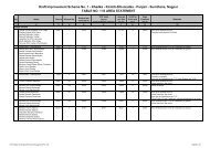
Sr. No. Item Percentage <strong>of</strong> land<br />
Land owner’s share<br />
1 Reconstituted plots <strong>for</strong> original owner 50%<br />
including internal roads and other<br />
amenities, as required.<br />
N.I.T.’S Share<br />
2 Roads (Major and D.P. Roads) 18% ^\<br />
3 Water bodies / sewage disposal areas 2%<br />
4 Institutional area 5%<br />
5 Parks / Gardens / Playgrounds and<br />
open spaces<br />
6 Housing <strong>for</strong> Weaker Section 4%<br />
7 Residential land bank <strong>for</strong> NIT 7%<br />
8 Commercial land bank <strong>for</strong> NIT 4%<br />
Total 100%<br />
10% >50%<br />
Once the Town Planning Scheme is ready, it will be notified <strong>for</strong> the<br />
in<strong>for</strong>mation <strong>of</strong> public at large in daily local news <strong>paper</strong>s and all the land owners<br />
will be called <strong>for</strong> a meeting by the Nagpur Improvement Trust. The scheme is<br />
explained to the owners and taking into consideration the views <strong>of</strong> the owners if<br />
needed the scheme will be marginally modified and will be published and notified<br />
under Section 39 <strong>of</strong> the Nagpur Improvement Trust Act 1936. and also notices<br />
will be issued to the property owners under Section 41 <strong>of</strong> the Nagpur<br />
Improvement Trust Act 1936, within 30 days from the date <strong>of</strong> first notification
under section 39 <strong>of</strong> the NIT Act 1936.(<strong>for</strong> acquisition <strong>of</strong> land by agreement).<br />
7. The FSI <strong>of</strong> the allotted final plot will be given one.(1.00). which means land<br />
owner will get 50% FSI <strong>of</strong> total land (including FSI <strong>of</strong> internal roads and other<br />
amenities, as required) i.e. 100% <strong>of</strong> final plot area allotted to land owner.<br />
8 .Looking in to the existing infrastructure and developments, the standard <strong>of</strong><br />
proposed development works i.e. roads, water pipe line, sewer line, storm<br />
drains, development <strong>of</strong> gardens, open spaces, electricity will be decided.<br />
9. Requirement <strong>of</strong> water will be calculated and source <strong>of</strong> water will be<br />
identified and water will be provided through existing irrigation projects <strong>of</strong><br />
the area or new water bodies will be created in <strong>consultation</strong> with Irrigation<br />
Department. The area <strong>for</strong> disposal <strong>of</strong> sewerage and sanitation will be<br />
identified looking into the topography <strong>of</strong> the area and area will be marked<br />
<strong>for</strong> the disposal <strong>of</strong> sewerage and decentralized Sewage Treatment plants<br />
(STP) will be constructed on BOT or otherwise.<br />
10. The development cost <strong>of</strong> all infrastructure i.e. roads, sewer lines, water<br />
pipe line, storm drains, culverts, nallah bridges, gardens, parks etc. will be<br />
calculated.<br />
11. The cost <strong>of</strong> commercial and residential retainable land with Nagpur<br />
Improvement Trust as per ready reckonner will be deducted from the total<br />
cost <strong>of</strong> development works.<br />
12. The per square feet cost <strong>of</strong> development works will be calculated after<br />
deducting cost <strong>of</strong> commercial and residential land banks <strong>of</strong> Nagpur<br />
Improvement Trust as per ready reckonner value and development cost along<br />
with development charges as per section 124 A ,124 B and Second schedule<br />
<strong>of</strong> MRTP Act 1966, will be recovered from the original land owners on the<br />
basis <strong>of</strong> net land area remained with them (Final plot area).
13. MOU will be signed with the land owners regarding the following :-<br />
a) That the total 100% land will be theoretically vest with NIT.<br />
b) 50% <strong>of</strong> the total land holding will be retained by the owner.<br />
c) 50% <strong>of</strong> the total land holding shall vest in NIT free from all<br />
encumbrances <strong>for</strong> public purpose as mentioned in Point No. 6 (NIT<br />
share)<br />
d) Development cost per square foot <strong>of</strong> retained land shall be payable<br />
by landowner to NIT as mentioned in point No. 12.<br />
e) Once NIT decides the development cost (along with interest), the<br />
cost <strong>of</strong> development shall not be changed.<br />
f) NIT shall be responsible <strong>for</strong> the development works as mentioned<br />
from Para 8 to 10.<br />
14. After following the above procedure the proposal <strong>of</strong> TPS Scheme along<br />
with MOU <strong>of</strong> land owner will be kept be<strong>for</strong>e the Nagpur Improvement Trust<br />
Board and after board approval the T.P. scheme will be sent to Govt. <strong>for</strong><br />
approval under section 43 <strong>of</strong> the NIT Act 1936, along with proposal <strong>of</strong><br />
modification in Regional Plan under Section 20 <strong>of</strong> M.R.T.P. Act 1966 and<br />
Govt. will also be requested to transfer Govt. lands in the TPS area free <strong>of</strong><br />
cost to Nagpur Improvement Trust.<br />
15. After approval <strong>of</strong> TPS scheme from the Govt. under section 45 read with<br />
section 44, the final agreement towards development <strong>of</strong> scheme by public<br />
participation will be done with the land owners as per section 58 <strong>of</strong> NIT Act<br />
which empowers the Trust to enter into an agreement.<br />
16. In the meantime the estimates <strong>of</strong> development works i.e. roads, sewer line,<br />
storm drains, development <strong>of</strong> parks and Gardens etc. will be prepared.<br />
17. The tenders will be floated <strong>for</strong> development works and development works will
e started in the TPS area on the lands handed over by land owners <strong>for</strong><br />
construction <strong>of</strong> roads, sewer line and development <strong>of</strong> parks / gardens and<br />
opens spaces etc.<br />
18. In case open land is not available and there are existing structures it will<br />
not possible to take 50% land as proposed above , the land owners has to<br />
pay complete infrastructural development cost along with compounding<br />
charges <strong>for</strong> regularizing existing construction, The land owners will have to<br />
hand over open spaces and public utility spaces <strong>of</strong> the lay out to the NIT.<br />
In case <strong>of</strong> road widening in the existing layouts, land / plot owners has<br />
to surrender the required land <strong>for</strong> road widening without any demur.<br />
ADVANTAGES OF PUBLIC PARTICIPATION METHOD<br />
1. As per conventional method <strong>of</strong> acquisition land owner will get :-<br />
a. Compensation only on compulsory acquisition <strong>of</strong> their land as per<br />
section 59 <strong>of</strong> NIT Act, 1936.<br />
OR One developed plot <strong>of</strong> 4000 Sft. per acre<br />
<strong>of</strong> land acquired by NIT as compensation as per Govt. decision vide<br />
letter Dated 17.1.1992.<br />
b. As per U.D.P.F.I. (Urban Development Non Formulation and<br />
Implementation) guidelines, proposed land use structure <strong>of</strong> Urban<br />
Center in plain areas <strong>for</strong> development <strong>of</strong> metro cities. The<br />
residential land use allowable is 35-40 % <strong>of</strong> total land.<br />
As per above proposed Public Participation Method land owner will get 50%<br />
<strong>of</strong> total land area which has enormous land value and better in shape<br />
buildability and accessibility.<br />
2 The above proposed method is rational, equitable and democratic. By<br />
implementing T.P. scheme the buildability <strong>of</strong> reconstituted plot increases<br />
with regular shape, <strong>improvement</strong> accessibility, increase potential <strong>of</strong><br />
development, availability <strong>of</strong> social and physical infrastructure, better<br />
linkage with other parts <strong>of</strong> the city and <strong>improvement</strong> in living environment.
3 Land is rightly used as a resource with the increased build ability, market<br />
value <strong>of</strong> land goes up. This results in accruing increment in land value to<br />
the owner. The owners <strong>of</strong> net gainers from the Town Planning Scheme as<br />
such they can contribute towards the cost <strong>of</strong> the development in<br />
proportion to their benefits.<br />
4 Under T.P. Scheme area <strong>for</strong> roads and public purposes is taken without<br />
dispossessing the owners totally. Such area <strong>for</strong> public purposes is almost<br />
equitably shared by all the land owners <strong>of</strong> the scheme in proportion to the<br />
area <strong>of</strong> their land and no person whose land falls under reservation is victim<br />
<strong>of</strong> his private rights being subordinated to public interest. Everybody is getting<br />
50% <strong>of</strong> his total land share.<br />
5 Peoples participation is ensured under the provision <strong>of</strong> this method as such<br />
local authorities give due consideration to the land owners in preparation and<br />
<strong>implementation</strong> <strong>of</strong> the scheme.<br />
6 Planning ef<strong>for</strong>ts can keep pace with the growth and rapid urbanization<br />
thereby reducing scope <strong>for</strong> haphazard urban sprawl. T.P. scheme facilitates<br />
decentralization <strong>of</strong> plan development activities in core as well as outlaying<br />
area <strong>of</strong> the city.<br />
7 T.P. scheme encourages optimum use <strong>of</strong> scarce developed urban land<br />
through efficient layouts and using <strong>of</strong> urban land as a resource to check land<br />
speculation.<br />
8 Effective people participation in the planning process ensures timely consent<br />
<strong>of</strong> land owner which reduces the scope <strong>of</strong> future litigation and conflicts during<br />
<strong>implementation</strong> <strong>of</strong> the scheme.<br />
9 The method involves assembling small landholdings into a large land<br />
parcel, providing it with infrastructure in a planned manner, and returning<br />
the reconstituted land to the owners with additional benefits like roads,<br />
parks and access to other public utility services. The infrastructure<br />
expense is recovered by the sale <strong>of</strong> some <strong>of</strong> the serviced land and<br />
development charges.<br />
Public Participation Method can be the first choice <strong>for</strong> <strong>implementation</strong> <strong>of</strong><br />
NIT Schemes. NIT, can implement the scheme by resorting to Section 26 <strong>of</strong>
Nagpur Improvement Trust Act 1936, read with Section 58 <strong>of</strong> NIT Act.<br />
Section 26 empowers the NIT to acquire the land by purchase, exchange or<br />
otherwise which mean that the NIT can acquire the land and implement the<br />
scheme by public participation also. Under section 58 <strong>of</strong> the NIT Act, the NIT<br />
can inter into an agreement with any person <strong>for</strong> acquisition by purchase,<br />
lease or exchange within the area comprise in sanctioned scheme. This<br />
mode by <strong>implementation</strong> <strong>of</strong> scheme by public participation is more effective.<br />
In case if it is not feasible to implement the scheme by public participation<br />
in that case, NIT will have no other option but resort to section 59 <strong>of</strong> NIT Act <strong>for</strong><br />
compulsory acquisition under the Land Acquisition Act 1894 as per the scheme<br />
plan proposed by NIT.<br />
Public is hereby in<strong>for</strong>med to give their opinion, views and suggestions in<br />
writing to the Superintending Engineer, Nagpur Improvement Trust, Station<br />
Road, Sadar, Nagpur-440 001 or mail their views , opinion and suggestions at<br />
<strong>nagpur</strong>nit@hotmail.com.