InSAR Results from the RADARSAT Antarctic Mapping ... - GeoGratis
InSAR Results from the RADARSAT Antarctic Mapping ... - GeoGratis
InSAR Results from the RADARSAT Antarctic Mapping ... - GeoGratis

You also want an ePaper? Increase the reach of your titles
YUMPU automatically turns print PDFs into web optimized ePapers that Google loves.
ACKNOWLEDGMENTS<br />
Dirk Geudtner (DLR) provided help and<br />
software for our early work on <strong>RADARSAT</strong><br />
interferometry. The Canadian Space Agency,<br />
CSA, and <strong>RADARSAT</strong> International, RSI, also<br />
helped in making data available to CCRS in<br />
order to do an initial evaluation of <strong>the</strong> potential<br />
of interferometry.<br />
REFERENCE<br />
1. Goldstein, R.M., H. Englehardt, B. Lamb,<br />
and R.M. Frolich, Satellite radar<br />
interferometry for monitoring ice sheet<br />
motion: Application to an <strong>Antarctic</strong> ice<br />
stream, Science, 262, 1525-1530, 1993.<br />
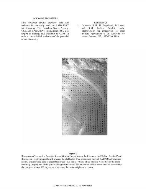
Figure 2<br />
Illustration of ice motion <strong>from</strong> <strong>the</strong> Slessor Glacier (upper left) as <strong>the</strong> ice enters <strong>the</strong> Filchner Ice Shelf and<br />
flows as an ice stream northward towards <strong>the</strong> shelf edge. Two mosaicked pairs of <strong>RADARSAT</strong> standard<br />
mode 2 images were used to create this image (100 km x 170 km) of ice motion. Velocities in <strong>the</strong> more<br />
sou<strong>the</strong>rly (upper) part of <strong>the</strong> glacier change <strong>from</strong> around 250 m/year as <strong>the</strong> ice enters <strong>the</strong> area covered by<br />
<strong>the</strong> image to almost 800 m/year as it leaves at <strong>the</strong> bottom right-hand corner.<br />
0-7803-4403-0/98/$10.00 (c) 1998 IEEE