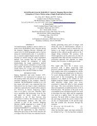
The Use of Radar Remote Sensing for Identifying Environmental ...
The Use of Radar Remote Sensing for Identifying Environmental ...
The Use of Radar Remote Sensing for Identifying Environmental ...

You also want an ePaper? Increase the reach of your titles
YUMPU automatically turns print PDFs into web optimized ePapers that Google loves.
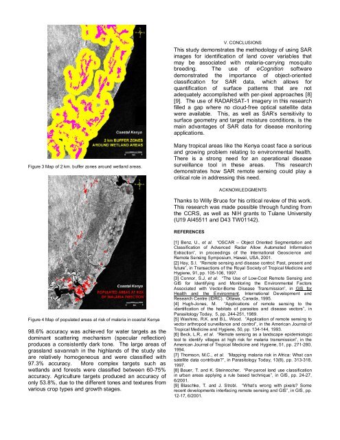
Figure 3 Map <strong>of</strong> 2 km. buffer zones around wetland areas.<br />
Figure 4 Map <strong>of</strong> populated areas at risk <strong>of</strong> malaria in coastal Kenya<br />
98.6% accuracy was achieved <strong>for</strong> water targets as the<br />
dominant scattering mechanism (specular reflection)<br />
produces a consistently dark tone. <strong>The</strong> large areas <strong>of</strong><br />
grassland savannah in the highlands <strong>of</strong> the study site<br />
are relatively homogeneous and were classified with<br />
97.3% accuracy. More complex targets such as<br />
wetlands and <strong>for</strong>ests were classified between 60-75%<br />
accuracy. Agriculture targets produced an accuracy <strong>of</strong><br />
only 53.8%, due to the different tones and textures from<br />
various crop types and growth stages.<br />
V. CONCLUSIONS<br />
This study demonstrates the methodology <strong>of</strong> using SAR<br />
images <strong>for</strong> identification <strong>of</strong> land cover variables that<br />
may be associated with malaria-carrying mosquito<br />
breeding. <strong>The</strong> use <strong>of</strong> eCognition s<strong>of</strong>tware<br />
demonstrated the importance <strong>of</strong> object-oriented<br />
classification <strong>for</strong> SAR data, which allows <strong>for</strong><br />
quantification <strong>of</strong> surface patterns that are not<br />
adequately accomplished with per-pixel approaches [8]<br />
[9]. <strong>The</strong> use <strong>of</strong> RADARSAT-1 imagery in this research<br />
filled a gap where no cloud-free optical satellite data<br />
were available. This, as well as SAR’s sensitivity to<br />
surface geometry and target moisture conditions, is the<br />
main advantages <strong>of</strong> SAR data <strong>for</strong> disease monitoring<br />
applications.<br />
Many tropical areas like the Kenya coast face a serious<br />
and growing problem relating to environmental health.<br />
<strong>The</strong>re is a strong need <strong>for</strong> an operational disease<br />
surveillance tool in these areas. This research<br />
demonstrates how SAR remote sensing could play a<br />
critical role in addressing this need.<br />
ACKNOWLEDGMENTS<br />
Thanks to Willy Bruce <strong>for</strong> his critical review <strong>of</strong> this work.<br />
This research was made possible through funding from<br />
the CCRS, as well as NIH grants to Tulane University<br />
(U19 AI45511 and D43 TW01142).<br />
REFERENCES<br />
[1] Benz, U., et al. “OSCAR – Object Oriented Segmentation and<br />
Classification <strong>of</strong> Advanced <strong>Radar</strong> Allow Automated In<strong>for</strong>mation<br />
Extraction”, in proceedings <strong>of</strong> the International Geoscience and<br />
<strong>Remote</strong> <strong>Sensing</strong> Symposium, Hawaii, USA, 2001.<br />
[2] Hay, S.I. “<strong>Remote</strong> sensing and disease control: Past, present and<br />
future”, in Transactions <strong>of</strong> the Royal Society <strong>of</strong> Tropical Medicine and<br />
Hygiene, 91, pp. 105-106, 1997.<br />
[3] Connor, S.J, et al. “<strong>The</strong> <strong>Use</strong> <strong>of</strong> Low-Cost <strong>Remote</strong> <strong>Sensing</strong> and<br />
GIS <strong>for</strong> <strong>Identifying</strong> and Monitoring the <strong>Environmental</strong> Factors<br />
Associated with Vector-Borne Disease Transmission”, in GIS <strong>for</strong><br />
Health and the Environment, International Development and<br />
Research Centre (IDRC). Ottawa, Canada, 1995.<br />
[4] Hugh-Jones, M. “Applications <strong>of</strong> remote sensing to the<br />
identification <strong>of</strong> the habitats <strong>of</strong> parasites and disease vectors”, in<br />
Parasitology Today, 5, pp. 244-251, 1989.<br />
[5] Washino, R.K. and B.L. Wood. “Application <strong>of</strong> remote sensing to<br />
vector arthropod surveillance and control”, in the American Journal <strong>of</strong><br />
Tropical Medicine and Hygiene, 50, pp. 134-144, 1993.<br />
[6] Beck, L.R., et al. “<strong>Remote</strong> sensing as a landscape epidemiologic<br />
tool to identify villages at high risk <strong>for</strong> malaria transmission”, in the<br />
American Journal <strong>of</strong> Tropical Medicine and Hygiene, 51, pp. 271-280,<br />
1994.<br />
[7] Thomson, M.C., et al. “Mapping malaria risk in Africa: What can<br />
satellite data contribute?”, in Parasitology Today, 13(8), pp. 313-318,<br />
1997.<br />
[8] Bauer, T. and K. Steinnocher. “Per-parcel land use classification<br />
in urban areas applying a rule based technique”, in GIS, pp. 24-27,<br />
6/2001.<br />
[9] Blaschke, T. and J. Strobl. “What’s wrong with pixels? Some<br />
recent developments interfacing remote sensing and GIS”, in GIS, pp.<br />
12-17, 6/2001.