Radosław Janicki - EVRICA
Radosław Janicki - EVRICA
Radosław Janicki - EVRICA

Create successful ePaper yourself
Turn your PDF publications into a flip-book with our unique Google optimized e-Paper software.
358 R. <strong>Janicki</strong><br />
This way, comparable maps of the same terrains (Park, Łomna and Łętownia<br />
village) from different years were achieved. Computer-aided spatial data analysis and<br />
modelling, through the use of Geographical Information Systems (GIS) software, such as<br />
ArcView version 3.2 were conducted. To rectify maps, ArcInfo was used in a few cases.<br />
ArcView was used, to analyse land use changes. Each theme of each map has its attributes:<br />
point themes have numbers, linear themes have numbers and length and polygonal –<br />
numbers and area. Lengths and areas were calculated using script „calcapl.ave" suggested<br />
by the authors of the ArcView software. Once those data are available, ArcView can show<br />
the statistics of each theme such as: sum, count, mean, maximum, minimum, range,<br />
variance and standard deviation. Given data were noted down and are show below in table 1.<br />
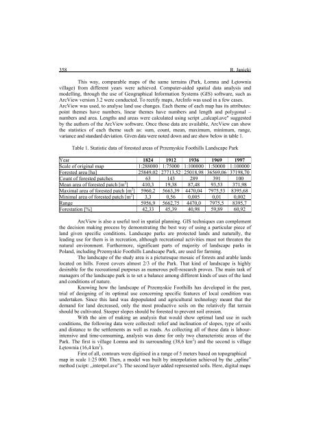
Table 1. Statistic data of forested areas of Przemyskie Foothills Landscape Park<br />
Year 1824 1912 1936 1969 1997<br />
Scale of original map 1:288000 1:75000 1:100000 1:50000 1:100000<br />
Forested area [ha] 25849,02 27713,52 25018,98 36569,06 37198,70<br />
Count of forested patches 63 143 289 391 100<br />
Mean area of forested patch [m 2 ] 410,3 19,38 87,48 93,53 371,98<br />
Maximal area of forested patch [m 2 ] 5960,2 5663,39 4470,04 7975,53 8395,68<br />
Minimal area of forested patch [m 2 ] 3,3 0,56 0,005 0,01 0,002<br />
Range 5956,9 5662,75 4470,0 7975,5 8395,7<br />
Forestation [%] 42,33 45,39 40,98 59,89 60,92<br />
ArcView is also a useful tool in spatial planning. GIS techniques can complement<br />
the decision making process by demonstrating the best way of using a particular piece of<br />
land given specific conditions. Landscape parks are protected lands and naturally, the<br />
leading use for them is in recreation, although recreational activities must not threaten the<br />
natural environment. Furthermore, significant parts of majority of landscape parks in<br />
Poland, including Przemyskie Foothills Landscape Park, are used for farming.<br />
The landscape of the study area is a picturesque mosaic of forests and arable lands<br />
located on hills. Forest covers almost 2/3 of the Park. That kind of landscape is highly<br />
desirable for the recreational purposes as numerous poll-research proves. The main task of<br />
managers of the landscape park is to set a balance among different kinds of uses of the land<br />
and conditions of nature.<br />
Knowing how the landscape of Przemyskie Foothills has developed in the past,<br />
trial of designing of its optimal use concerning specific features of local condition was<br />
undertaken. Since this land was depopulated and agricultural technology meant that the<br />
demand for land decreased, only the most productive soils on the relatively flat terrain<br />
should be cultivated. Steeper slopes should be forested to prevent soil erosion.<br />
With the aim of making an analysis that would show optimal land use in such<br />
conditions, the following data were collected: relief and inclination of slopes, type of soils<br />
and distance to the settlements as well as roads. As collecting all of these data is labourintensive<br />
and time-consuming, analysis was done for only two characteristic areas of the<br />
Park. The first is village Łomna and its surrounding (38,6 km 2 ) and the second is village<br />
Łętownia (16,4 km 2 ).<br />
First of all, contours were digitised in a range of 5 meters based on topographical<br />
map in scale 1:25 000. Then, a model was built by interpolation achieved by the „spline”<br />
method (scipt: „interpol.ave”). The second layer added represented soils. Here, digital maps