

Land Management Plan - Part 2 Los Padres National Forest Strategy
Land Management Plan - Part 2 Los Padres National Forest Strategy
Land Management Plan - Part 2 Los Padres National Forest Strategy

Create successful ePaper yourself
Turn your PDF publications into a flip-book with our unique Google optimized e-Paper software.
United States Department<br />
of Agriculture<br />
<strong>Forest</strong> Service<br />
Pacific Southwest Region<br />
R5-MB-078<br />
September 2005<br />
<strong>Land</strong> <strong>Management</strong> <strong>Plan</strong><br />
<strong>Part</strong> 2 <strong>Los</strong> <strong>Padres</strong> <strong>National</strong><br />
<strong>Forest</strong> <strong>Strategy</strong>
The U.S. Department of Agriculture (USDA) prohibits discrimination in all its programs and activities on the basis of race, color,<br />
national origin, age, disability, and where applicable, sex, marital status, familial status, parental status, religion, sexual<br />
orientation, genetic information, political beliefs, reprisal, or because all or part of an individual's income is derived from any<br />
public assistance program. (Not all prohibited bases apply to all programs.) Persons with disabilities who require alternative<br />
means for communication of program information (Braille, large print, audiotape, etc.) should contact USDA's TARGET Center<br />
at (202) 720-2600 (voice and TDD).<br />
To file a complaint of discrimination, Write to USDA, Director, Office of Civil Rights, 1400 Independence Avenue, S.W.,<br />
Washington, D.C. 20250-9410, or call (800) 795-3272 (voice) or (202) 720-6382 (TDD). USDA is an equal opportunity provider<br />
and employer.
<strong>Land</strong> <strong>Management</strong> <strong>Plan</strong><br />
<strong>Part</strong> 2 <strong>Los</strong> <strong>Padres</strong> <strong>National</strong> <strong>Forest</strong> <strong>Strategy</strong><br />
R5-MB-078<br />
September 2005
Table of Contents<br />
Tables ....................................................................................................................................................v<br />
Document Format Protocols................................................................................................................ vi<br />
LAND MANAGEMENT PLAN STRATEGY..................................................................................1<br />
Suitable <strong>Land</strong> Uses ......................................................................................................................................2<br />
<strong>Land</strong> Use Zones.........................................................................................................................................2<br />
Special Designation Overlays..................................................................................................................11<br />
Scenery <strong>Management</strong> System..................................................................................................................16<br />
Public Uses Regulated by Other Agencies..............................................................................................16<br />
Prospectus ..................................................................................................................................................17<br />
Program Emphasis and Objectives..........................................................................................................17<br />
Monitoring Trends and Performance Indicators..................................................................................18<br />
General Budget History.......................................................................................................................19<br />
<strong>Management</strong> and Administration ........................................................................................................19<br />
Resource <strong>Management</strong> ........................................................................................................................20<br />
Public Use and Enjoyment ..................................................................................................................25<br />
Facilities Operation and Maintenance .................................................................................................28<br />
Commodity and Commercial Uses......................................................................................................30<br />
Fire <strong>Management</strong>.................................................................................................................................32<br />
Place-Based Program Emphasis ..............................................................................................................35<br />
Arroyo Seco.........................................................................................................................................36<br />
Avenales ..............................................................................................................................................39<br />
Big Sur.................................................................................................................................................41<br />
Black Mountain ...................................................................................................................................45<br />
Colson..................................................................................................................................................47<br />
Cuesta ..................................................................................................................................................49<br />
Cuyama-Highway 166 Front ...............................................................................................................52<br />
Figueroa - Santa Ynez .........................................................................................................................55<br />
Highway 33 Corridor...........................................................................................................................58<br />
Hungry Valley - Mutau .......................................................................................................................61<br />
Mt. Pinos .............................................................................................................................................64<br />
Ojai - Piru Front Country ....................................................................................................................67<br />
Pozo - La Panza...................................................................................................................................70<br />
Rockfront.............................................................................................................................................72<br />
San Rafael............................................................................................................................................74<br />
Santa Barbara Front.............................................................................................................................77<br />
Sespe....................................................................................................................................................80<br />
Ventana................................................................................................................................................83<br />
<strong>Forest</strong>-Specific Design Criteria ...............................................................................................................85<br />
Place-specific Standards......................................................................................................................85<br />
Wilderness Standards ..........................................................................................................................85<br />
<strong>Forest</strong>-wide Guidance..........................................................................................................................85<br />
Performance Risks...................................................................................................................................85<br />
Page i
APPENDIX A - SPECIAL DESIGNATION OVERLAYS - LOS PADRES NATIONAL FOREST<br />
....................................................................................................................................................87<br />
Wilderness................................................................................................................................................. 87<br />
Existing Wilderness................................................................................................................................87<br />
Chumash Wilderness.......................................................................................................................... 87<br />
Dick Smith Wilderness....................................................................................................................... 87<br />
Garcia Wilderness .............................................................................................................................. 87<br />
Machesna Mountain Wilderness ........................................................................................................ 88<br />
Matilija Wilderness ............................................................................................................................ 88<br />
San Rafael Wilderness........................................................................................................................ 88<br />
Santa Lucia Wilderness ...................................................................................................................... 89<br />
Sespe Wilderness................................................................................................................................89<br />
Silver Peak Wilderness....................................................................................................................... 89<br />
Ventana Wilderness............................................................................................................................ 90<br />
Recommended Wilderness ..................................................................................................................... 91<br />
Chumash - Toad Springs (Chumash Wilderness)............................................................................... 91<br />
Madulce-Buckhorn (Dick Smith Wilderness) .................................................................................... 91<br />
Matilija (Matilija Wilderness) ............................................................................................................ 91<br />
Mono (Dick Smith Wilderness).......................................................................................................... 92<br />
Wild and Scenic Rivers ............................................................................................................................ 93<br />
Designated .............................................................................................................................................. 93<br />
Sespe Creek ........................................................................................................................................ 93<br />
Big Sur River...................................................................................................................................... 93<br />
Sisquoc River ..................................................................................................................................... 93<br />
Wild and Scenic Rivers, Recommended for Designation ...................................................................... 93<br />
Piru Creek........................................................................................................................................... 93<br />
Sespe Creek ........................................................................................................................................ 93<br />
Arroyo Seco River.............................................................................................................................. 94<br />
Research Natural Areas........................................................................................................................... 95<br />
Established.............................................................................................................................................. 95<br />
American Canyon............................................................................................................................... 95<br />
Black Butte ......................................................................................................................................... 95<br />
San Emigdio Mesa.............................................................................................................................. 95<br />
Cone Peak Gradient............................................................................................................................ 95<br />
Proposed ................................................................................................................................................. 96<br />
Big Pine Mountain.............................................................................................................................. 96<br />
Sawmill Mountain .............................................................................................................................. 96<br />
White Mountain.................................................................................................................................. 97<br />
Valley Oak.......................................................................................................................................... 97<br />
Ventana Cones.................................................................................................................................... 98<br />
Special Interest Areas............................................................................................................................. 99<br />
Cuesta Ridge....................................................................................................................................... 99<br />
Dry Lakes Ridge................................................................................................................................. 99<br />
Mount Pinos Summit.......................................................................................................................... 99<br />
Quatal Canyon.................................................................................................................................... 99<br />
Sierra Madre ..................................................................................................................................... 100<br />
Alder Creek ...................................................................................................................................... 100<br />
Page ii
Lion Den Spring ................................................................................................................................100<br />
Southern Redwood ............................................................................................................................100<br />
Foster Bear Ponds..............................................................................................................................100<br />
Camatta..............................................................................................................................................102<br />
Mono Basin .......................................................................................................................................103<br />
Milpitas..............................................................................................................................................104<br />
APPENDIX B - PROGRAM STRATEGIES AND TACTICS.....................................................107<br />
Tribal 1 - Traditional and Contemporary Uses....................................................................................108<br />
Tribal 2 - Government to Government Relations.................................................................................108<br />
AM 1 - <strong>Land</strong> <strong>Management</strong> <strong>Plan</strong> Monitoring and Evaluation .............................................................109<br />
AM 2 - <strong>Forest</strong>-wide Inventory................................................................................................................109<br />
WL 1 - Threatened, Endangered, Proposed, Candidate, and Sensitive Species <strong>Management</strong>.........111<br />
WL 2 - Wildlife, Fish and <strong>Plan</strong>t Habitat <strong>Management</strong>........................................................................115<br />
IS 1 - Invasive and Nonnative Species Prevention and Control ..........................................................116<br />
FH 1 - Vegetation Restoration................................................................................................................117<br />
FH 3 - Restoration of <strong>Forest</strong> Health ......................................................................................................117<br />
FH 4 - Insect and Disease <strong>Management</strong>.................................................................................................118<br />
Air 1 - Minimize Smoke and Dust..........................................................................................................119<br />
Air 2 - <strong>Forest</strong> Air Quality Emissions .....................................................................................................119<br />
WAT 1 - Watershed Function ................................................................................................................120<br />
WAT 2 - Water <strong>Management</strong>.................................................................................................................121<br />
WAT 3 - Hazardous Materials ...............................................................................................................122<br />
Link 1 - Habitat Linkage <strong>Plan</strong>ning ........................................................................................................123<br />
SD 1 - Wilderness ....................................................................................................................................124<br />
SD 2 - Wild and Scenic Rivers................................................................................................................125<br />
SD 3 - Research Natural Areas...............................................................................................................125<br />
SD 4 - Special Interest Areas ..................................................................................................................125<br />
Her 1 - Heritage Resource Protection....................................................................................................126<br />
Her 2 - Public Involvement Program.....................................................................................................126<br />
Her 3 - <strong>Forest</strong>-wide Heritage Inventory ................................................................................................126<br />
Her 4 - Heritage Research ......................................................................................................................127<br />
REC 1 - Recreation Opportunity ...........................................................................................................128<br />
REC 2 - Sustainable Use and Environmental Design...........................................................................128<br />
REC 3 - Recreation <strong>Part</strong>icipation ..........................................................................................................129<br />
REC 4 - Conservation Education...........................................................................................................129<br />
REC 5 - Recreation Special Use Authorizations...................................................................................130<br />
Page iii
LM 1 - <strong>Land</strong>scape Aesthetics................................................................................................................. 131<br />
LM 2 - <strong>Land</strong>scape Restoration.............................................................................................................. 131<br />
LM 3 - <strong>Land</strong>scape Character ................................................................................................................ 131<br />
Law 1 - Enforcement and Investigations.............................................................................................. 132<br />
Fac 1 - Facilities Maintenance Backlog ................................................................................................ 133<br />
Trans 1 - Transportation System .......................................................................................................... 134<br />
Trans 2 - Unnecessary Roads ................................................................................................................ 134<br />
Trans 3 - Improve Trails........................................................................................................................ 135<br />
Trans 4 - Off-Highway Vehicle Opportunities..................................................................................... 135<br />
SFP 1 - Offer Special <strong>Forest</strong> Products.................................................................................................. 136<br />
<strong>Land</strong>s 1 - <strong>Land</strong> Ownership Adjustment............................................................................................... 137<br />
<strong>Land</strong>s 2 - Non-Recreation Special Use Authorizations ....................................................................... 138<br />
<strong>Land</strong>s 3 - Boundary <strong>Management</strong>......................................................................................................... 139<br />
<strong>Land</strong>s 4 - Mineral Withdrawals ............................................................................................................ 139<br />
ME 1 - Minerals <strong>Management</strong>............................................................................................................... 140<br />
ME 2 - Biomass Utilization .................................................................................................................... 140<br />
LG 1 - Livestock Grazing....................................................................................................................... 141<br />
LG 2 - Rangeland Health....................................................................................................................... 142<br />
LG 3 - Wildhorse Territories................................................................................................................. 142<br />
Fire 1 - Fire Prevention.......................................................................................................................... 143<br />
Fire 2 - Direct Community Protection.................................................................................................. 143<br />
Fire 4 - Firefighter and Public Safety ................................................................................................... 144<br />
Fire 5 - Fuelbreaks and Indirect Community Protection ................................................................... 144<br />
APPENDIX C. MAPS...............................................................................................................145<br />
<strong>Los</strong> <strong>Padres</strong> Northern Division ............................................................................................................... 145<br />
<strong>Los</strong> <strong>Padres</strong> Central................................................................................................................................. 145<br />
<strong>Los</strong> <strong>Padres</strong> South .................................................................................................................................... 145<br />
Page iv
Tables<br />
Note: Tables were managed in a database environment, and were assigned unique numbers as<br />
their need was identified. During the lifetime of the analysis, over 500 tables were created for<br />
potential use. Some tables were later determined to be redundant or unnecessary. The planning<br />
team decided not to renumber the tables for publication due to the amount of work required to<br />
locate and update every reference to every table. Thus, the table numbers are not consecutive, and<br />
all table numbers were not used in the final documents.<br />
TABLE 2.3.1. SUITABLE USES RESOURCE MANAGEMENT, LPNF ........................................2<br />
TABLE 2.3.2. SUITABLE USES PUBLIC USE AND ENJOYMENT, LPNF ..................................3<br />
TABLE 2.3.3. SUITABLE USES COMMODITY AND COMMERCIAL USES, LPNF ....................4<br />
TABLE 2.3.4. SUITABLE USES FIRE AND FUELS MANAGEMENT, LPNF ...............................5<br />
TABLE 526. LOS PADRES NF CRITICAL BIOLOGICAL LAND USE ZONES ...........................9<br />
TABLE 476. DESIGNATED COMMUNICATION SITES, LOS PADRES NATIONAL FOREST .14<br />
TABLE 486. DESIGNATED UTILITY CORRIDORS - LOS PADRES NATIONAL FOREST ......15<br />
TABLE 480. RECREATION RESIDENCE TRACTS, LOS PADRES NATIONAL FOREST .......15<br />
TABLE 490. DESIGNATED SHOOTING AREAS - LOS PADRES NATIONAL FOREST ..........15<br />
TABLE 2.3.5. RESOURCE MANAGEMENT PERFORMANCE INDICATORS, LPNF ...............24<br />
TABLE 2.3.6. PUBLIC USE AND ENJOYMENT PERFORMANCE INDICATORS, LPNF .........28<br />
TABLE 2.3.7. FACILITIES OPERATIONS AND MAINTENANCE PERFORMANCE<br />
INDICATORS, LPNF...................................................................................................................30<br />
TABLE 2.3.8. COMMODITIES AND COMMERCIAL USES PERFORMANCE INDICATORS,<br />
LPNF...........................................................................................................................................32<br />
TABLE 2.3.9. FIRE AND AVIATION MANAGEMENT PERFORMANCE INDICATORS, LPNF .34<br />
TABLE 530. LOS PADRES NF CONSERVATION STRATEGY..............................................112<br />
Page v
Document Format Protocols<br />
The following format protocols (font type, size, and strength, as well as indentation) are used<br />
throughout the <strong>Land</strong> <strong>Management</strong> <strong>Plan</strong>.<br />
All headings are Arial bold, in varying font sizes and indentation.<br />
Text is generally Times New Roman, 12 point regular.<br />
Table Titles are Arial, bold, 11 point.<br />
Table column headings are in Arial Narrow, 10 pt, with a shaded background.<br />
Table cell contents are Times New Roman, 12 point.<br />
Photograph captions have a top and bottom border to separate them from regular text, and are<br />
12 point Arial font. For example, this is a clip-art butterfly.<br />
References to websites (URLs) are in OCR B MT, 10 point in the printed version. In the<br />
electronic version, these are live links. The electronic version is posted at:<br />
http://www.fs.fed.us/r5/lospadres/projects/lmp<br />
Page vi
<strong>Land</strong> <strong>Management</strong> <strong>Plan</strong> <strong>Strategy</strong><br />
This document is <strong>Part</strong> 2 of the three-part (vision, strategy and design criteria) land and resource<br />
management plan (forest plan) for the <strong>Los</strong> <strong>Padres</strong> <strong>National</strong> <strong>Forest</strong>. The strategic direction and<br />
program emphasis objectives that are expected to result in the sustainability (social, economic<br />
and ecological) of the national forest and, over the long-term, the maintenance of a healthy forest<br />
are described in this document. The legislative mandate for the management of national forests<br />
requires that public lands be conservatively used and managed in order to ensure their<br />
sustainability and to guarantee that future generations will continue to benefit from their many<br />
values. 1 <strong>Forest</strong> plans are founded on the concept of sustainable use of the national forests. In its<br />
simplest terms, sustainability means to maintain or prolong. In order to foster the concept of<br />
sustainability, this section describes the program emphasis and strategies that may be employed<br />
to enable multiple uses to occur in ways that promote long-term sustainability. The program<br />
emphasis and management strategies are continuously projected over a three to five year period<br />
(over the life of the plan) in order to describe the projects or activities that may be employed as<br />
we move along the pathways toward the realization of the desired conditions described in <strong>Part</strong> 1<br />
of the revised forest plan.<br />
<strong>Part</strong> 1 describes the national forest in the future, the<br />
niche it occupies in the community framework, the<br />
desired conditions the <strong>Forest</strong> Service is striving to<br />
realize, as well as the challenges the national forest<br />
will resolve in getting there. <strong>Part</strong> 2 supplements <strong>Part</strong><br />
1 of the forest plan. <strong>Part</strong> 2 also constitutes the 'tools'<br />
resource staff will use to accomplish the objectives<br />
that contribute to the realization of the desired<br />
conditions. <strong>Part</strong> 2 defines and describes each of the<br />
land use zones. The land use zones are an on-theground<br />
manifestation of the desired conditions and<br />
are the primary tools used to describe the strategic<br />
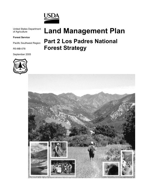
California Condor<br />
direction, including the management intent and<br />
suitable uses for areas of the national forest where<br />
the zone is used. <strong>Part</strong> 2 also includes a prospectus describing the past performance history of the<br />
national forest and the anticipated performance in three to five year increments over the life of<br />
the forest plan. Place-Based Program Emphasis is also described so that people will have a<br />
better understanding of what types of management is expected in specific areas of the national<br />
forest. Finally, <strong>Part</strong> 2 addresses the monitoring to be done to assess the effective implementation<br />
of the strategies used.<br />
<strong>Part</strong> 3 of the forest plan is the design criteria and constitutes the 'rules' that the <strong>Forest</strong> Service<br />
will follow as the national forest implements projects and activities over time. The rules include<br />
the laws, agency policy, standards, and the associated guidance that is referenced for use at the<br />
project level.<br />
1 Committee of Scientists issued a final report on March 15, 1999, entitled Sustaining the People’s <strong>Land</strong>s<br />
Page 1
<strong>Land</strong> <strong>Management</strong> <strong>Plan</strong> <strong>Part</strong> 2<br />
<strong>Los</strong> <strong>Padres</strong> <strong>National</strong> <strong>Forest</strong> <strong>Strategy</strong><br />
Suitable <strong>Land</strong> Uses<br />
September 2005<br />
<strong>Land</strong> Use Zones<br />
<strong>Land</strong> use zones (CFR 219.11(c)) were used to map the <strong>Los</strong> <strong>Padres</strong> <strong>National</strong> <strong>Forest</strong> (LPNF) for<br />
the purpose of identifying appropriate management types of ‘uses’ that are consistent with the<br />
achievement of the desired conditions described in <strong>Part</strong> 1 of the revised forest plan (see <strong>Land</strong><br />
Use Zone Maps in Appendix C). These land use zones are used to help demonstrate clearly<br />
management’s intent and to indicate the anticipated level of public land use in any area (Place) of<br />
the national forest. The activities that are allowed in each zone are expected to result in progress<br />
along the pathway toward the realization of the desired conditions. <strong>National</strong> <strong>Forest</strong> land use<br />
zoning is similar in concept to the zoning models that are being used by counties or<br />
municipalities throughout southern California. Tables 2.3.1 through 2.3.4 display the suitability<br />
of specific uses by land use zone (note: recommended wilderness and existing wilderness zones<br />
are combined into the wilderness zone column on the tables).<br />
Table 2.3.1. Suitable Uses Resource <strong>Management</strong>, LPNF<br />
<strong>Land</strong> Use Zone: DAI BC BCMUR BCNM CB W<br />
Activity or Use<br />
Developed<br />
Areas Interface<br />
Back Country Back Country<br />
Motorized Use<br />
Restricted<br />
Back Country<br />
Non-Motorized<br />
Critical<br />
Biological Wilderness<br />
Rangeland Type<br />
Conversion for Not Suitable<br />
Forage production<br />
Not<br />
Suitable<br />
Not<br />
Suitable Not Suitable Not<br />
Suitable<br />
Not<br />
Suitable<br />
Restoration of<br />
Vegetation<br />
Condition<br />
Suitable Suitable Suitable<br />
Suitable<br />
*By<br />
Exception Suitable<br />
Disposal of<br />
<strong>National</strong> <strong>Forest</strong><br />
System lands<br />
* By<br />
Exception<br />
* By<br />
*By<br />
*By Exception<br />
Exception<br />
Exception<br />
*By Not<br />
Exception Suitable<br />
* By Exception = Conditions which are not generally compatible with the land use zone but may be appropriate under certain<br />
circumstances .<br />
Page 2
September 2005 <strong>Land</strong> <strong>Management</strong> <strong>Plan</strong> <strong>Part</strong> 2<br />
<strong>Los</strong> <strong>Padres</strong> <strong>National</strong> <strong>Forest</strong> <strong>Strategy</strong><br />
Table 2.3.2. Suitable Uses Public Use and Enjoyment, LPNF<br />
<strong>Land</strong> Use Zone: DAI BC BCMUR BCNM CB W<br />
Activity or Use<br />
Recreation<br />
Residence<br />
Tracts<br />
Organization<br />
Camps<br />
Lodges, Resorts<br />
and Clubs<br />
Hunting and<br />
Fishing<br />
Developed<br />
Areas Interface<br />
Designated<br />
Areas<br />
Designated<br />
Areas<br />
Designated<br />
Areas<br />
Regulated<br />
by the State<br />
(CDF&G)<br />
Back Country Back Country<br />
Motorized Use<br />
Restricted<br />
Designated<br />
Areas<br />
Designated<br />
Areas<br />
Designated<br />
Areas<br />
Regulated<br />
by the State<br />
(CDF&G)<br />
Page 3<br />
Back Country<br />
Non-Motorized<br />
Critical<br />
Biological<br />
Not Suitable Not Suitable Not<br />
Suitable<br />
Not Suitable Not Suitable Not<br />
Suitable<br />
Not Suitable Not Suitable Not<br />
Regulated<br />
by the State<br />
(CDF&G)<br />
Regulated<br />
by the State<br />
(CDF&G)<br />
Suitable<br />
Regulated<br />
by the<br />
State<br />
(CDF&G)<br />
Wilderness<br />
Not Suitable<br />
Not Suitable<br />
Not Suitable<br />
Regulated<br />
by<br />
the State<br />
( CDF&G)<br />
Target Shooting *By<br />
Areas Exception<br />
Public<br />
Designated Areas<br />
Designated Areas<br />
Designated Areas<br />
Not<br />
Suitable<br />
Not Suitable<br />
Motorized Use<br />
on <strong>Forest</strong><br />
System Roads<br />
Suitable Suitable<br />
Not<br />
Not Suitable Not Suitable<br />
Suitable<br />
Not Suitable<br />
Authorized<br />
Suitable<br />
Motorized Use<br />
Off-Highway<br />
Suitable Suitable<br />
*By *By *By<br />
Exception Exception Exception<br />
Vehicle Use on<br />
<strong>Forest</strong> System<br />
Roads and<br />
Trails<br />
Public<br />
Designated<br />
Roads and<br />
Trails<br />
Designated<br />
Roads and<br />
Trails<br />
Not<br />
Not Suitable Not Suitable<br />
Suitable<br />
Not Suitable<br />
Motorized Use<br />
off <strong>Forest</strong><br />
System Roads<br />
and Trails<br />
Suitable in Suitable in<br />
Not<br />
Designated Designated Not Suitable Not Suitable<br />
Suitable<br />
Open Areas Open Areas<br />
Not Suitable<br />
Mountain Bikes<br />
Unless<br />
<strong>Forest</strong> System<br />
Otherwise<br />
Roads and<br />
Restricted<br />
Trails<br />
Unless<br />
Otherwise<br />
Restricted<br />
Unless<br />
Otherwise<br />
Restricted<br />
Unless Unless<br />
Otherwise Otherwise Not Suitable<br />
Restricted Restricted<br />
Suitable Suitable Suitable Suitable<br />
Suitable<br />
Dispersed Area Unless Unless Unless Unless Not Unless<br />
Camping Otherwise Otherwise Otherwise Otherwise Suitable Otherwise<br />
Restricted Restricted Restricted Restricted Restricted
<strong>Land</strong> <strong>Management</strong> <strong>Plan</strong> <strong>Part</strong> 2<br />
<strong>Los</strong> <strong>Padres</strong> <strong>National</strong> <strong>Forest</strong> <strong>Strategy</strong><br />
September 2005<br />
* By Exception = Conditions which are not generally compatible with the land use zone but may<br />
be appropriate under certain<br />
circumstances .<br />
Table 2.3.3. Suitab le Uses Com modity and Commercial Uses, LPNF<br />
<strong>Land</strong> Use Zone: DAI BC BCMUR BCNM CB W<br />
Developed<br />
Activity or Use Areas<br />
Interface<br />
(Non-Rec) Special<br />
Uses: Low Intensity Suitable<br />
Back Country<br />
Back Country Motorized Use<br />
Restricted<br />
Back Country<br />
Non-Motorized<br />
Critical<br />
Biological Wilderness<br />
<strong>Land</strong> Use<br />
Suitable Suitable<br />
*By<br />
Exception<br />
*By *By<br />
Exception Exception<br />
Communication Designated Designated Designated *By *By Not<br />
Sites<br />
Areas Areas Areas Exception Exception Suitable<br />
Livestock Grazing Designated Designated Designated<br />
Areas Areas Areas<br />
Designated Not<br />
Areas Suitable<br />
Designated<br />
Areas<br />
Major<br />
Transportation<br />
Corridors<br />
Designated Designated<br />
Not Suitable<br />
Areas Areas<br />
Not<br />
Suitable<br />
Not<br />
Suitable<br />
Not<br />
Suitable<br />
Major Utility Designated Designated Designated Not Not Not<br />
Corridors Areas Areas Areas Suitable Suitable Suitable<br />
Road construction<br />
or re-construction<br />
Suitable Suitable<br />
Suitable<br />
for<br />
authorized<br />
use<br />
Not<br />
Suitable<br />
Not<br />
Suitable<br />
Not<br />
Suitable<br />
Developed Facilities Suitable Suitable<br />
*By<br />
Exception<br />
Not<br />
Suitable<br />
Not<br />
Suitable<br />
Not<br />
Suitable<br />
Oil and Gas<br />
Exploration<br />
and Suitable<br />
Development<br />
Areas<br />
Suitable *By<br />
Exception<br />
*By Not Not<br />
Exception Suitable Suitable<br />
Minerals Resources<br />
Exploration and<br />
Suitable<br />
Development<br />
Suitable<br />
*By<br />
Exception<br />
*By<br />
Exception<br />
*By Not<br />
Exception Suitable<br />
Renewable Energy<br />
Suitable<br />
Resources<br />
Suitable<br />
*By<br />
Exception<br />
*By<br />
Exception<br />
Not<br />
Suitable<br />
Not<br />
Suitable<br />
Wood Products,<br />
including fuelwood Suitable<br />
harvesting<br />
Suitable Suitable Suitable<br />
*By Not<br />
Exception Suitable<br />
Special <strong>Forest</strong><br />
Products<br />
Suitable Suitable Suitable Suitable<br />
*By *By<br />
Exception Exception<br />
* By Exception = Conditions which are not generally compatible with the land use zone but may be appropriate under certain<br />
circumstances.<br />
Page 4
September 2005 <strong>Land</strong> <strong>Management</strong> <strong>Plan</strong> <strong>Part</strong> 2<br />
<strong>Los</strong> <strong>Padres</strong> <strong>National</strong> <strong>Forest</strong> <strong>Strategy</strong><br />
Table 2.3.4. Suitable Uses Fire and Fuels <strong>Management</strong>, LPNF<br />
<strong>Land</strong> Use Zone: DAI BC BCMUR BCNM CB W<br />
Activity or Use<br />
Community<br />
Protection Areas<br />
Fuelbreak<br />
Construction<br />
including type<br />
conversion<br />
Wildland Fire Use<br />
<strong>Strategy</strong><br />
Developed<br />
Areas<br />
Interface<br />
Back<br />
Country<br />
Back Country<br />
Motorized Use<br />
Restricted<br />
Page 5<br />
Back Country<br />
Non-Motorized<br />
Suitable Suitable Suitable Suitable<br />
Suitable Suitable Suitable<br />
Not<br />
Suitable<br />
Not<br />
Suitable<br />
*By<br />
Exception<br />
Not<br />
Not Suitable Not Suitable<br />
Suitable<br />
Critical<br />
Biological Wilderness<br />
*By *By<br />
Exception Exception<br />
*By *By<br />
Exception Exception<br />
Not<br />
Suitable<br />
* By Exception = Conditions which are not generally compatible with the land use zone but may be appropriate under certain<br />
circumstances.<br />
Specific uses are allowed on national forests except when identified as not suitable, because of<br />
law, national or regional policy, or the revised forest plan. What this means is that the forest<br />
plans are permissive. That is, activities may occur unless the forest plan says that they cannot.<br />
However, activities are not authorized based solely on the land use zoning for this forest plan.<br />
The suitable uses identified in tables 2.3.1 through 2.3.4 are intended as guidance for<br />
consideration of future activities and do not affect existing authorized occupancy and uses or the<br />
administrative procedures used to manage them. Most ground disturbing activities require further<br />
project or site-specific analysis before a decision is made. The uses that are identified as suitable<br />
in each of the land use zones are subject to the design criteria, as well as other guidance<br />
described in <strong>Part</strong> 3 (Appendix A) of this forest plan. The standards, along with applicable<br />
guidance are typically used during project or site-specific planning. Applicable guidance includes<br />
the body of information encompassed by the <strong>Forest</strong> Service Manual and Handbooks, Species<br />
Accounts, Best <strong>Management</strong> Practices, Soil and Water Conservation Handbooks, the Built<br />
Environment Image Guide, or other documents with guidance that is identified for use based on<br />
site-specific project analysis.<br />
Several activities are described in the suitable use tables as being permitted in designated areas<br />
only. For example, what this means is that motorized uses are restricted to designated roads and<br />
trails and may be restricted or expanded further in order to achieve the desired condition for the<br />
land use zones. Vehicular traffic traveling cross-country or on non-designated routes is not<br />
allowed in any zone.<br />
Seven land use zones have been identified for the <strong>Los</strong> <strong>Padres</strong> <strong>National</strong> <strong>Forest</strong> (see <strong>Land</strong> Use<br />
Zone maps in Appendix C). These zones, including overlays described in the following section<br />
are applicable to only the <strong>National</strong> <strong>Forest</strong> System lands and in no way modify zoning applied to<br />
other ownerships by local government agencies. When other lands are acquired and become<br />
<strong>National</strong> <strong>Forest</strong> System lands, then the adjacent land use zones are applied unless changed<br />
through a <strong>Forest</strong> <strong>Plan</strong> Amendment. The land use zones descriptions in this section help to paint a<br />
picture of the anticipated level or intensity of public use or administrative activities. The existing<br />
character of each zone is included, along with the characteristic Recreation Opportunity
<strong>Land</strong> <strong>Management</strong> <strong>Plan</strong> <strong>Part</strong> 2<br />
<strong>Los</strong> <strong>Padres</strong> <strong>National</strong> <strong>Forest</strong> <strong>Strategy</strong><br />
September 2005<br />
Spectrum (ROS) objective (see Recreation Opportunity Spectrum Maps in Appendix C). The<br />
zones, in order of decreasing land use intensity are:<br />
• Developed Area Interface (DAI)<br />
• Back Country (BC)<br />
• Back Country Motorized Use Restricted (BCMUR)<br />
• Back Country Non-Motorized (BCNM)<br />
• Critical Biological (CB)<br />
• Recommended Wilderness (RW)<br />
• Existing Wilderness (EW)<br />
Developed Area Interface (60,150 acres or 3.4 percent of the national forest): This zone<br />
includes areas adjacent to communities or concentrated developed areas with more scattered or<br />
isolated community infrastructure. The level of human use and infrastructure is typically higher<br />
than in other zones.<br />
The characteristic ROS objectives are Rural and Roaded Natural. A number of highly popular<br />
developed recreation facilities, recreation and non-recreation special-uses facilities and national<br />
forest administrative facilities may be included in this zone. The level of development within<br />
this zone varies between areas that are highly developed to areas where no development has<br />
occurred.<br />
The DAI zone is managed for motorized public access. Approximately 11.8 percent of the<br />
<strong>National</strong> <strong>Forest</strong> System and non-system user created routes are found in this zone including 33<br />
miles of unclassified road. The <strong>National</strong> <strong>Forest</strong> System roads are generally managed and<br />
maintained to a higher standard, facilitating public access to developed recreation opportunities<br />
and authorized infrastructure. A designated off-highway vehicle (OHV) system may be included<br />
in some locations, often including trailheads or staging areas leading to Back Country areas.<br />
Most direct community protection Wildland/Urban Interface Defense Zones (see Appendix K in<br />
<strong>Part</strong> 3 of the forest plan) and some Threat Zones are anticipated to be located within the DAI<br />
zone.<br />
Although this zone may have a broad range of higher intensity uses, the management intent is to<br />
limit development to a slow increase of carefully designed facilities to help direct use into the<br />
most suitable areas and concentrating on improving facilities before developing new ones.<br />
<strong>National</strong> <strong>Forest</strong> staff expect that there will be some road construction, but anticipate no more<br />
than a 5 percent net-increase in road mileage.<br />
Back Country (332,172 acres or 18.6 percent of the national forest): This zone includes areas<br />
of the national forest that are generally undeveloped with few roads. The characteristic ROS<br />
objectives are Semi-Primitive Motorized with limited areas of Roaded Natural. Most of the<br />
national forest’s remote recreation and administrative facilities are found in this zone. The level<br />
of human use and infrastructure is generally low to moderate.<br />
The zone is managed for motorized public access on designated roads and trails. Approximately<br />
57.8 percent of the <strong>National</strong> <strong>Forest</strong> System and non-system roads are found in this zone<br />
including 140 miles of unclassified road. Some roads within this zone may be closed to public<br />
access. The majority of <strong>National</strong> <strong>Forest</strong> System roads and other road systems that interconnect<br />
Page 6
September 2005 <strong>Land</strong> <strong>Management</strong> <strong>Plan</strong> <strong>Part</strong> 2<br />
<strong>Los</strong> <strong>Padres</strong> <strong>National</strong> <strong>Forest</strong> <strong>Strategy</strong><br />
areas of concentrated development are found in this zone. A network of low-standard remote<br />
roads provide access for a wide variety of dispersed recreation opportunities in remote areas such<br />
as camping and access to trailhead facilities for hiking or biking. Some new trails may be<br />
constructed to improve opportunities between trails on the existing system. The majority of the<br />
designated OHV system is found here.<br />
Wildland/Urban Interface Threat Zones (see Appendix K in <strong>Part</strong> 3 of the forest plan) are<br />
characteristic in this zone. Managers anticipate locating community protection vegetation<br />
treatments that require permanent roaded access (such as fuelbreaks) within the Back Country<br />
zone.<br />
Although this zone generally allows a broad range of uses, the management intent is to retain the<br />
natural character inherent in this zone and limit the level and type of development. <strong>National</strong><br />
<strong>Forest</strong> staff expect to manage the zone for no increase or a very low level of increase in <strong>National</strong><br />
<strong>Forest</strong> System roads. Managers expect to limit development to a slow increase of carefully<br />
designed facilities to help direct use into the most suitable areas and remove temporary facilities<br />
when they are no longer needed.<br />
Back Country (Motorized Use Restricted) (319,884 acres or 18 percent of the national<br />
forest): This zone includes areas of the national forest that are generally undeveloped with few<br />
roads. Few facilities are found in this zone, but some may occur in remote locations. The<br />
characteristic ROS objectives are Semi-Primitive Motorized and Semi-Primitive Non-Motorized.<br />
The level of human use and infrastructure is low to moderate.<br />
The zone will be managed for non-motorized (mechanized, equestrian, and pedestrian) public<br />
access. Motorized use is restricted to administrative purposes only that include <strong>Forest</strong> Service,<br />
other agency, or tribal government needs, as well as access needed to private land or authorized<br />
special-uses. Administrative access is intermittent and generally limited to existing roads or to<br />
temporary roads needed for resource management purposes. The intent is to use temporary roads<br />
or gated permanent roads while management is occurring and then gate the permanent roads or<br />
remove the temporary route when done.<br />
Approximately 25.9 percent of the <strong>National</strong> <strong>Forest</strong> System and non-system roads are found in<br />
this zone including 114 miles of unclassified road. A limited number of <strong>National</strong> <strong>Forest</strong> System<br />
roads and other road systems that access administrative and authorized facilities and private land<br />
are found here. A network of low-standard remote roads provides access for a wide variety of<br />
non-motorized dispersed recreation opportunities including camping, hiking, biking, hunting and<br />
fishing. Designated OHV use is not suitable in this zone.<br />
Wildland/Urban Interface Threat Zones (see Appendix K in <strong>Part</strong> 3 of the forest plan) are<br />
characteristic in this zone. Managers anticipate locating community protection vegetation<br />
treatments that require permanent roaded access (such as fuelbreaks) within the Back Country<br />
Motorized Use Restricted zone.<br />
Although this zone allows a range of low intensity land uses, the management intent is to retain<br />
the natural character of the zone and limit the level and type of development. Some roads will be<br />
constructed and maintained, but the intent is to manage the zone for no increase or a very low<br />
level of increase in system development. Managers will consider expanding the ability of<br />
Page 7
<strong>Land</strong> <strong>Management</strong> <strong>Plan</strong> <strong>Part</strong> 2<br />
<strong>Los</strong> <strong>Padres</strong> <strong>National</strong> <strong>Forest</strong> <strong>Strategy</strong><br />
September 2005<br />
existing facilities to meet demand before proposing new facilities and removing temporary<br />
facilities when they are no longer needed.<br />
Back Country Non-Motorized (171,035 acres or 9.6 percent of the national forest): This<br />
zone generally includes areas of the national forest that are undeveloped with few, if any roads.<br />
The characteristic ROS objective is Semi-Primitive Non-Motorized. Developed facilities<br />
supporting dispersed recreation activities are minimal and generally limited to trails and signage.<br />
The level of human use and infrastructure is low.<br />
The zone is managed for a range of non-motorized uses that include mechanized, equestrian and<br />
pedestrian public access. Administrative access (usually for community protection) is allowed<br />
by exception for emergency situations and for short duration management purposes (such as fuel<br />
treatment). The intent is to use temporary routes while management is occurring and then close<br />
or remove the route. Access to authorized facilities and to private land is not anticipated, but<br />
may occur by exception when there are existing rights to such access.<br />
Approximately 1.8 percent of the <strong>National</strong> <strong>Forest</strong> System and non-system roads are found in this<br />
zone including 17 miles of unclassified road. A network of low-standard Back Country trails<br />
provide public access for a wide variety of non-motorized dispersed recreation opportunities<br />
including remote area camping, hiking, mountain biking, hunting and fishing. Designated OHV<br />
use is not suitable in this zone, and no designated OHV routes are located in this zone.<br />
Wildland/Urban Interface Threat Zones (see Appendix K in <strong>Part</strong> 3 of the forest plan) may occur<br />
in this zone. Managers anticipate locating community protection vegetation treatments that<br />
require only temporary roaded access (such as mechanical thinning of trees or prescribed<br />
burning) within the Back Country Non-Motorized zone.<br />
While a range of non-motorized public uses are generally allowed, the management intent is to<br />
typically retain the undeveloped character and natural appearance (fuelbreaks that contrast with<br />
the natural character may be present) of this zone and to limit the level of development to a low<br />
level of increase. Facility construction (except trails) is generally not allowed, but may occur in<br />
remote locations where roaded access is not needed for maintenance. Managers are expected to<br />
remove temporary facilities when they are no longer needed.<br />
Critical Biological (1,641 acres or 0.1 percent of the national forest): This zone includes the<br />
most important areas on the national forest to manage for the protection of species-at-risk.<br />
Facilities are minimal to discourage human use. The level of human use and infrastructure is low<br />
to moderate.<br />
Wildland/Urban Interface Threat Zones (see Appendix K in <strong>Part</strong> 3 of the forest plan) may occur<br />
in this zone. Community protection vegetation treatments within the critical biological land use<br />
zone may occur by exception. In these cases, managers will consider species and habitat needs.<br />
The management intent is to retain the natural character and habitat characteristics in this zone<br />
and limit the level of human development to manage for protection of species-at-risk. Activities<br />
and modification to existing infrastructure are allowed if they are beneficial or neutral to the<br />
species for which the zone was primarily designated (see table 526: <strong>Los</strong> <strong>Padres</strong> NF Critical<br />
Biological <strong>Land</strong> Use Zones). Human uses are more restricted in this zone than in Back Country<br />
Non-Motorized in order to protect species needs, but are not excluded. Low impact uses, such as<br />
hiking, mountain biking and hunting are generally allowed. Motorized use of existing <strong>National</strong><br />
<strong>Forest</strong> System roads may be regulated. Approximately .2 percent of the <strong>National</strong> <strong>Forest</strong> System<br />
Page 8
September 2005 <strong>Land</strong> <strong>Management</strong> <strong>Plan</strong> <strong>Part</strong> 2<br />
<strong>Los</strong> <strong>Padres</strong> <strong>National</strong> <strong>Forest</strong> <strong>Strategy</strong><br />
and non-system roads are found in this zone, including one mile of unclassified road. Road<br />
density will not be increased and may be decreased as a result of species protection requirements.<br />
Table 526. <strong>Los</strong> <strong>Padres</strong> NF Critical Biological <strong>Land</strong> Use Zones<br />
CBLUZ<br />
Upper<br />
Piru<br />
Upper<br />
Sespe<br />
Mono<br />
Creek<br />
Indian<br />
Creek<br />
Middle<br />
Santa<br />
Ynez<br />
Upper<br />
Santa<br />
Ynez<br />
Primary Species<br />
Protected<br />
Arroyo toad<br />
Primary Species Protected and Primary Uses<br />
Place(s)<br />
Sespe,<br />
Hungry -<br />
Valley<br />
Mutau<br />
Arroyo toad Sespe<br />
Arroyo toad,<br />
California red- Figueroa -<br />
legged frog, Santa Ynez<br />
Least Bell’s vireo<br />
Arroyo toad,<br />
California red- Figueroa -<br />
legged frog, Santa Ynez<br />
Least Bell’s vireo<br />
Arroyo toad,<br />
California red- Figueroa -<br />
legged frog, Santa Ynez<br />
Least Bell’s vireo<br />
Arroyo toad,<br />
Figueroa -<br />
California red-<br />
Santa Ynez<br />
legged frog<br />
Primary Uses<br />
This is a partial list of activities associated with these CBLUZ's.<br />
See Suitable Use Tables (<strong>Part</strong> 2) for full description of all suitable<br />
uses.<br />
Current uses of hiking, fishing, mountain biking on<br />
Hardluck Campground Road, and use of the USGS<br />
gauge are retained. However, during the breeding<br />
season for arroyo toad, camping at Hardluck<br />
Campground and use of Hardluck Campground Rd.<br />
by motor vehicles is not a suitable use.<br />
Hiking and fishing are retained. Unsuitable uses have<br />
already been removed through Lion Campground<br />
decommissioning.<br />
Current uses of camping, hiking, fishing, biking are<br />
retained<br />
Current uses of camping, hiking, fishing, biking are<br />
retained<br />
Current uses of hiking, fishing, biking are retained<br />
Hiking, fishing, and biking are retained<br />
Existing Wilderness (860,678 acres or 48.3 percent of the national forest): This zone<br />
includes Congressionally designated wildernesses. Only uses consistent with all applicable<br />
wilderness legislation and with the primitive character are allowed in existing and recommended<br />
wildernesses. Road access is limited to uses identified in the specific legislation designating the<br />
wilderness (see wilderness in the forest-specific design criteria of <strong>Part</strong> 2 of the forest plan).<br />
Approximately 2.5 percent of the <strong>National</strong> <strong>Forest</strong> System and non-system roads are found in this<br />
zone including 19 miles of unclassified road. The characteristic Recreation Opportunity<br />
Spectrum objective is Primitive with limited areas of Semi-Primitive Non-Motorized.<br />
Wildland/Urban Interface Threat Zones (see Appendix K in <strong>Part</strong> 3 of the forest plan) may occur<br />
in this zone. Community Protection vegetation treatments within the existing wilderness zone<br />
may occur by exception. In these cases, managers will consider wilderness needs.<br />
Page 9
<strong>Land</strong> <strong>Management</strong> <strong>Plan</strong> <strong>Part</strong> 2<br />
<strong>Los</strong> <strong>Padres</strong> <strong>National</strong> <strong>Forest</strong> <strong>Strategy</strong><br />
September 2005<br />
The management intent is to administer this zone for the use and enjoyment of people while<br />
preserving its wilderness character and natural conditions. Non-conforming uses will be removed<br />
to preserve wilderness character. Designated wilderness includes:<br />
• Chumash Wilderness<br />
• Dick Smith Wilderness<br />
• Garcia Wilderness<br />
• Machesna Mountain Wilderness<br />
• Matilija Wilderness<br />
• San Rafael Wilderness<br />
• Santa Lucia Wilderness<br />
• Sespe Wilderness<br />
• Silver Peak Wilderness<br />
• Ventana Wilderness<br />
Recommended Wilderness (35,821 acres or 2 percent of the national forest): This zone<br />
includes land that the <strong>Forest</strong> Service is recommending to Congress for wilderness designation<br />
and will be managed in the same manner as existing wilderness so that the wilderness attributes<br />
of the area are retained until Congress passes legislation, or the area is released from<br />
consideration. If Congress elects to not designate an area, the area would be zoned as Back<br />
Country Non-Motorized until modified by a subsequent plan amendment; there are no roads in<br />
this zone.<br />
Wildland/Urban Interface Threat Zones (see Appendix K in <strong>Part</strong> 3 of the forest plan) may occur<br />
in this zone. Community protection vegetation treatments within the recommended wilderness<br />
land use zone may occur by exception. In these cases, managers will consider wilderness needs.<br />
The management intent is to administer this zone for the use and enjoyment of people while<br />
preserving its wilderness character and natural conditions. Wilderness recommendations include:<br />
• Chumash - Toad Springs (Chumash Wilderness)section20_20_10_20_10.htm<br />
• Madulce-Buckhorn (Dick Smith Wilderness)<br />
• Matilija (Matilija Wilderness)section20_20_10_20_70.htm<br />
• Mono (Dick Smith Wilderness)<br />
Page 10
September 2005 <strong>Land</strong> <strong>Management</strong> <strong>Plan</strong> <strong>Part</strong> 2<br />
<strong>Los</strong> <strong>Padres</strong> <strong>National</strong> <strong>Forest</strong> <strong>Strategy</strong><br />
Special Designation Overlays<br />
<strong>Land</strong> use designations overlay the land use zones. Suitable uses identified in the land use zone<br />
tables are generally suitable in these overlay classifications unless specifically excluded. When<br />
differences occur in suitable uses between the land use zone and special designation, the more<br />
restrictive set of allowable uses applies.<br />
Wild and Scenic River<br />
Wild and Scenic River eligibility (an inventory and evaluation of whether a river is free-flowing<br />
and possesses one or more outstandingly remarkable values (ORVs) including scenery,<br />
recreation, geology, fish and wildlife, history, cultural (prehistoric), or similar values) was<br />
completed for the four southern California national forests. If found eligible, a river segment<br />
was then analyzed as to its current level of development (water resources projects, shoreline<br />
development, and accessibility) and a recommendation was made that it be placed into one of<br />
three classes—wild, scenic or recreational. The final procedural step (suitability) provides the<br />
basis for determining whether to recommend to Congress an eligible river as part of the <strong>National</strong><br />
System.<br />
The <strong>Los</strong> <strong>Padres</strong> <strong>National</strong> <strong>Forest</strong> completed the suitability studies for the seven rivers determined<br />
eligible, including evaluation for suitability under the alternatives developed for this plan<br />
revision.<br />
Suitable uses are those compatible with protecting and enhancing the outstandingly remarkable<br />
values for which the river was designated or found eligible.<br />
Designated Rivers include:<br />
• Sespe Creek<br />
• Big Sur River<br />
• Sisquoc River<br />
Rivers recommended for designation include all eligible segments of:<br />
• Upper segment of Piru Creek<br />
• Upper segment of Sespe Creek<br />
• Arroyo Seco River<br />
All existing facilities, management actions, and approved uses will be allowed to continue in<br />
eligible river corridors until a decision is made on inclusion into the <strong>National</strong> Wild and Scenic<br />
River System, provided these facilities, actions, and uses do not interfere with the protection and<br />
enhancement of the river's outstandingly remarkable values.<br />
Proposed new facilities, management actions, or uses on national forest land are not allowed if<br />
they have the potential to affect the eligibility or potential classification of the river segment.<br />
Uses comply with <strong>Forest</strong> Service Handbook 1909.12, chapter 8.2, which includes a description<br />
of developments and activities that are permitted, restricted or prohibited within the designated<br />
river corridor for each of the three classifications (wild, scenic and recreational).<br />
Page 11
<strong>Land</strong> <strong>Management</strong> <strong>Plan</strong> <strong>Part</strong> 2<br />
<strong>Los</strong> <strong>Padres</strong> <strong>National</strong> <strong>Forest</strong> <strong>Strategy</strong><br />
Inventoried Roadless Areas<br />
September 2005<br />
Inventoried Roadless Areas (IRAs) were originally mapped as a result of the second Roadless<br />
Area Review (RARE II), which was documented in a final environmental impact statement dated<br />
January of 1979, and refined during development of the national forest land management plans.<br />
These maps were identified in a set of inventoried roadless area maps, contained in the <strong>Forest</strong><br />
Service Roadless Area Conservation Rule, Final Environmental Impact Statement, Volume 2,<br />
dated November 2000. A final Roadless Area Conservation Rule was published in May of 2005,<br />
allowing optional State government involvement through a petition process. Alternatively the<br />
1982 NFMA planning rule allows for the analysis and evaluation of roadless areas, including<br />
boundary adjustments, in the forest plan revision process. An updated inventory has been<br />
prepared to reflect changes in the roadless inventory due to analysis and evaluation made in this<br />
forest plan revision. Adjustments to the inventory include correction of mapping errors including<br />
boundary roads mistakenly included within an IRA, removal of those areas that Congress has<br />
designated as wilderness (21,123 acres on the <strong>Los</strong> <strong>Padres</strong> <strong>National</strong> <strong>Forest</strong>), addition of<br />
undeveloped areas that were not part of the original inventory but were recommended as<br />
wilderness in this forest plan, and implementation of the following classification to reflect the<br />
land use zoning decisions in the revised forest plan:<br />
• 1a - IRAs allocated to a prescription that does not allow road construction and the forest<br />
plan recommends as wilderness.<br />
• 1b - IRAs allocated to a prescription that does not allow road construction or<br />
reconstruction.<br />
• 1c - IRAs allocated to a prescription that allows road construction or reconstruction.<br />
(See the Inventoried Roadless Area Maps in Appendix C)<br />
Research Natural Areas<br />
Research Natural Areas are relatively undisturbed areas of the national forest that form a longterm<br />
network of ecological reserves designated for research, education, and the maintenance of<br />
biodiversity. This designation applies to both established and proposed research natural areas.<br />
Research Natural Areas are designated to preserve a spectrum of relatively pristine areas that<br />
represent a wide range of natural variability within important natural ecosystems and<br />
environments, and areas that have unique characteristics of scientific importance. Research<br />
Natural Areas are also selected for one or more of the following reasons:<br />
• To serve as reference areas for evaluating the range of natural variability and the impacts<br />
of management in similar environments.<br />
• To protect and maintain representative or key elements of biological diversity at the<br />
genetic, species, population, community, or ecosystem levels.<br />
• To serve as areas for the study of ecosystems and ecological processes including<br />
succession.<br />
• To provide onsite and extension educational activities.<br />
• To serve as baseline areas for measuring ecological change.<br />
Uses that retain the research values for which the site is designated are appropriate.<br />
Page 12
September 2005 <strong>Land</strong> <strong>Management</strong> <strong>Plan</strong> <strong>Part</strong> 2<br />
<strong>Los</strong> <strong>Padres</strong> <strong>National</strong> <strong>Forest</strong> <strong>Strategy</strong><br />
Established Research Natural Areas include:<br />
• American Canyon<br />
• Black Butte<br />
• San Emigdio Mesa<br />
• Cone Peak Gradient<br />
Recommended Research Natural Areas include:<br />
• Big Pine Mountain<br />
• Sawmill Mountain<br />
• White Mountain<br />
• Valley Oak<br />
• Ventana Cones<br />
Special Interest Areas<br />
Special Interest Areas protect and, where appropriate, foster public use and enjoyment of areas<br />
that feature scenic, historical, geological, botanical, zoological, paleontological, or other special<br />
characteristics. Uses that are compatible with maintaining the target of the areas designation are<br />
appropriate.<br />
Special Interest Areas include:<br />
• Cuesta Ridge<br />
• Dry Lakes Ridge<br />
• Mt. Pinos Summit<br />
• Quatal Canyon<br />
• Sierra Madre<br />
• Alder Creek<br />
• Lion Den Spring<br />
• Southern Redwood<br />
• Foster Bear Ponds<br />
• Camatta<br />
• Mono Basin<br />
• Milpitas<br />
Page 13
<strong>Land</strong> <strong>Management</strong> <strong>Plan</strong> <strong>Part</strong> 2<br />
<strong>Los</strong> <strong>Padres</strong> <strong>National</strong> <strong>Forest</strong> <strong>Strategy</strong><br />
Other Designations:<br />
Table 476. Designated Communication Sites, <strong>Los</strong> <strong>Padres</strong> <strong>National</strong> <strong>Forest</strong><br />
Communications Site<br />
Name<br />
Anderson Peak Non-Broadcast/ Low-power<br />
Vaqueros Peak Non-Broadcast/ Low-power<br />
Black Mountain Non-Broadcast/ Low-power<br />
Branch Mountain Non-Broadcast/ Low-power<br />
Cuesta Peak Broadcast/ High-power<br />
La Panza Non-Broadcast/ Low-power<br />
Mount Lowe Non-Broadcast/ Low-power<br />
Plowshare Peak Non-Broadcast/ Low-power<br />
Tassajera Peak Non-Broadcast/ Low-power<br />
Tepusquet Peak<br />
September 2005<br />
Existing Uses Approximate Location Restrictions<br />
Non-Broadcast/ Low-power/(south)<br />
Broadcast/ High-power/(north)<br />
Broadcast Peak Broadcast/ High-power<br />
Camino Cielo<br />
Single User VORTAC/ Non-Broadcast/<br />
Low-power<br />
La Cumbre Peak Non-Broadcast/ Low-power<br />
West La Cumbre Non-Broadcast/ Low-power<br />
Rattlesnake Pass Broadcast/ High-power<br />
West Santa Ynez<br />
Peak<br />
Non-Broadcast/ Low-power<br />
Santa Ynez Peak Non-Broadcast/ Low-power<br />
East Santa Ynez<br />
Peak<br />
Non-Broadcast/ Low-power<br />
Sisar Peak Non-Broadcast/ Low-power<br />
Page 14<br />
Sec. 21, T20S, R3E,<br />
MDM<br />
Sec. 3, T20S, R6E,<br />
MDM<br />
Sec 15, T29S, R15E,<br />
MDM<br />
Sec 31, T31S, R18E, Government<br />
MDM<br />
Only<br />
Sec 35, T29S, R12E,<br />
MDM<br />
Sec 15, T31S, R17E,<br />
MDM<br />
Sec 17, T30S, R13E,<br />
MDM<br />
Sec 4, T11S, R30E,<br />
SBM<br />
Sec 20, T29S, R12E,<br />
MDM<br />
Sec 30, T10S,<br />
R31W, SBM<br />
Sec 17, T5S, R29W,<br />
MDM<br />
Sec 13, T5N, R28W, Government<br />
SBM<br />
Only<br />
Sec 21, T5N, R27W, Restricted<br />
SBM<br />
Use<br />
Sec 20 & 21, T5N, Government<br />
R27W, SBM Only<br />
Sec 35, T5N, R27W, Restricted<br />
SBM<br />
Use<br />
Sec 11, T5N, R30W, Government<br />
SBM<br />
Only<br />
Sec 12, T5N, R30W,<br />
SBM<br />
Sec 12, T5N, R30W, Restricted<br />
SBM<br />
Use<br />
Sec 24, T5N, R22W, Government<br />
SBM<br />
Only
September 2005 <strong>Land</strong> <strong>Management</strong> <strong>Plan</strong> <strong>Part</strong> 2<br />
<strong>Los</strong> <strong>Padres</strong> <strong>National</strong> <strong>Forest</strong> <strong>Strategy</strong><br />
Communications Site<br />
Name<br />
Existing Uses Approximate Location Restrictions<br />
Frazier Mountain Non-Broadcast/ Low-power<br />
Sec 14 & 23, T8N,<br />
R20W, SBM<br />
McPherson Peak Non-Broadcast/ Low-power<br />
Sec 6, T9N, R27W,<br />
SBM<br />
Mount Abel Non-Broadcast/ Low-power<br />
Sec 26, T9N, R22W, Restricted<br />
SBM<br />
Use<br />
Mount Pinos<br />
Sec 6, T8N, R21W, Government<br />
Single User/Non-Broadcast/ Low-power<br />
SBM<br />
Only<br />
Olive Canyon Non-Broadcast/Low-power<br />
Sec 24, T9N, R26W, Restricted<br />
SBM<br />
Use<br />
Table 486. Designated Utility Corridors - <strong>Los</strong> <strong>Padres</strong> <strong>National</strong> <strong>Forest</strong><br />
Utility Corridor Name<br />
Approximate <strong>Land</strong> Area<br />
Acres Miles<br />
Existing Uses<br />
Midway Vincent #1 & #2 195 4.3 500KV lines (2), Fiber Optic Line<br />
Table 480. Recreation Residence Tracts, <strong>Los</strong> <strong>Padres</strong> <strong>National</strong> <strong>Forest</strong><br />
• Santa Lucia - Monterey RD<br />
• Figueroa - Santa Lucia RD<br />
• Oso - Santa Barbara RD<br />
• Santa Ynez - Santa Barbara RD<br />
• Chuchupate - Mt. Pinos RD<br />
Table 490. Designated Shooting Areas - <strong>Los</strong> <strong>Padres</strong> <strong>National</strong> <strong>Forest</strong><br />
Component Shooting Areas<br />
Concession-Operated Sites None<br />
Permitted Gun Clubs: Limited Winchester Gun Club<br />
or No Public Access Ojai Gun Club<br />
Designated Shooting Sites by<br />
<strong>Forest</strong> Order (Other Shooting 3 sites along Camino Cielo<br />
Restrictions May Apply)<br />
The rest of the <strong>Forest</strong> is generally closed to recreational<br />
shooting although sites have been identified where future<br />
Remainder of <strong>Forest</strong><br />
recreational shooting may be allowed under managed<br />
conditions per Standard S36.<br />
Page 15
<strong>Land</strong> <strong>Management</strong> <strong>Plan</strong> <strong>Part</strong> 2<br />
<strong>Los</strong> <strong>Padres</strong> <strong>National</strong> <strong>Forest</strong> <strong>Strategy</strong><br />
September 2005<br />
Scenery <strong>Management</strong> System<br />
The Scenery <strong>Management</strong> System (SMS) is a tool for integrating public benefits, values, desires,<br />
and preferences regarding aesthetics and scenery for all levels of land management planning.<br />
SMS includes specific scenic objectives that have been designated for all areas of the national<br />
forest. At the project level, all national forest activities are subject to review of the scenic<br />
integrity objectives (see Scenic Integrity Objective Maps in map appendix).<br />
Public Uses Regulated by Other Agencies<br />
The California Department of Fish and Game (CDF&G) manages California's fish and wildlife<br />
populations for their ecological values and for their use and enjoyment by the public.<br />
Hunting is permitted throughout the national<br />
forests of southern California during hunting<br />
seasons designated by the CDF&G. Hunting is<br />
not permitted in those areas where the discharge<br />
of firearms is prohibited by county ordinance,<br />
California State law, or federal regulations.<br />
Hunters must follow all laws including no<br />
hunting within 150 yards of a residence,<br />
building, campsite, developed recreation site or<br />
occupied area for safety. Except as permitted by<br />
CDF&G, it is unlawful to use a dog to<br />
pursue/take animals or to train a dog for<br />
hunting. The CDF&G may issue dog training and organizational field trial permits authorizing<br />
releasing and taking domestically reared game birds, bobwhite quail, or coturnix quail. Such<br />
organized events require a special-use authorization from the appropriate national forest office.<br />
Angling is encouraged in most areas of the national forests during fishing seasons designated by<br />
the CDF&G. Some locations have special regulations and a few are closed to fishing in order to<br />
protect the steelhead trout and other aquatic species that depend on high quality habitat.<br />
Page 16
September 2005 <strong>Land</strong> <strong>Management</strong> <strong>Plan</strong> <strong>Part</strong> 2<br />
<strong>Los</strong> <strong>Padres</strong> <strong>National</strong> <strong>Forest</strong> <strong>Strategy</strong><br />
Prospectus<br />
The prospectus describes recent trends and expectations regarding the levels of experiences,<br />
goods and services, or other outcomes that are supplied by the national forest, as well as<br />
anticipated resource improvements planned over the next three to five years. Past performance<br />
can be a good indicator of what is expected in the near future. Performance expectations are<br />
projected into the future. Annual monitoring and evaluation of trends in performance indicators<br />
determine if there is a need to shift program emphasis to more effectively move toward the<br />
desired conditions (see Monitoring Trends and Performance Indicators). Strategic program<br />
emphasis is described through specific objectives that the national forest will emphasize under<br />
current budget expectations. Utilizing Place-specific desired conditions and management<br />
emphasis from <strong>Part</strong> 2, the <strong>Forest</strong> Supervisor will plan and implement projects that contribute to<br />
achieving program-level desired conditions described in <strong>Part</strong> 1, while meeting the standards<br />
described in <strong>Part</strong> 3. Information in this prospectus will be updated on a regular basis to reflect<br />
changes in management emphasis or budget fluctuations. Specific strategies and tactics that are<br />
linked to program objectives are found in Appendix B. These are referenced from each of the<br />
applicable program objectives discussed in this section. The final section describes examples of<br />
performance risks that could cause a need for change in management emphasis (see Performance<br />
Risks).<br />
Program Emphasis and Objectives<br />
A methodology common to the four southern California national forests was applied during the<br />
development of the <strong>Forest</strong> Business <strong>Plan</strong> (http://www.fs.fed.us/r5/business-plans), in<br />
order to describe the activities and programs for the <strong>Los</strong> <strong>Padres</strong> <strong>National</strong> <strong>Forest</strong>. Activities were<br />
organized into six functional areas, which include all areas of business for which the national<br />
forest is responsible. The functional areas collectively include 35 programs. <strong>National</strong> <strong>Forest</strong><br />
management uses the results to clearly communicate program capability both internally and<br />
externally.<br />
The six functional areas are:<br />
• <strong>Management</strong> & Administration: <strong>National</strong> <strong>Forest</strong> leadership, management and<br />
administrative support activities, communications, external affairs, community outreach,<br />
planning, human resources, information technology, and financial management.<br />
• Resource <strong>Management</strong>: Activities related to managing, preserving, and protecting the<br />
national forest's cultural and natural resources.<br />
• Public Use & Enjoyment: Activities which provide visitors with safe, enjoyable and<br />
educational experiences while on the national forest and accommodate changing trends in<br />
visitor use and community participation and outreach.<br />
• Facility Operations & Maintenance: Activities required to manage and operate the<br />
national forest's infrastructure (i.e., roads, facilities, trails, and structures).<br />
• Commodity & Commercial Uses: Grazing management, forest special product<br />
development, and activities related to managing non-recreation special-uses such as<br />
national forest access, telecommunications sites, and utility corridors.<br />
Page 17
<strong>Land</strong> <strong>Management</strong> <strong>Plan</strong> <strong>Part</strong> 2<br />
<strong>Los</strong> <strong>Padres</strong> <strong>National</strong> <strong>Forest</strong> <strong>Strategy</strong><br />
September 2005<br />
• Fire & Aviation <strong>Management</strong>: Wildland fire prevention through education, hazardous<br />
fuels reduction, and proactive preparation. This program also includes on-forest wildland<br />
fire suppression, and national or international wildland fire and emergency incident<br />
response.<br />
Monitoring Trends and Performance Indicators<br />
Monitoring in <strong>Part</strong> 2 of the forest plan is focused on annual program implementation including<br />
inventory. The national forest currently uses performance indicators for tracking program<br />
accomplishments. The current system is expected to be augmented by a performance<br />
accountability system integrating annual budgets with programs of work and linking these to<br />
tracking of Strategic <strong>Plan</strong> performance indicators.<br />
Each of the key performance indicators is estimated for two budget levels in the performance<br />
history section; one based on the current budget trend and the other an estimate of the total<br />
capability and need for the program activity on the national forest assuming an unconstrained<br />
budget. Performance indicators are shown at the end of each management function section:<br />
• Resource <strong>Management</strong>, Resource <strong>Management</strong> Performance Indicators, LPNF (table<br />
2.3.5, page 24)<br />
• Public Use and Enjoyment, Public Use and Enjoyment Performance Indicators, LPNF<br />
(table 2.3.6, page 28)<br />
• Facilities Operation and Maintenance, Facilities Operations and Maintenance<br />
Performance Indicators, LPNF (table 2.3.7, page 30)<br />
• Commodity and Commercial Uses, Commodities and Commercial Uses Performance<br />
Indicators, LPNF (table 2.3.8, page 32)<br />
• Fire and Aviation <strong>Management</strong>, Fire and Aviation <strong>Management</strong> Performance Indicators,<br />
LPNF (table 2.3.9, page 34)<br />
Actual performance is tracked over time through annual documentation of accomplishment and<br />
these trends are evaluated periodically to determine if the national forest needs to shift program<br />
strategies (see The Three <strong>Part</strong>s of a <strong>Plan</strong><br />
in the Adaptive Cycle). This data is<br />
reported in the annual monitoring and<br />
evaluation report as part of the national<br />
forest's implementation monitoring<br />
efforts.<br />
Page 18<br />
Inventory is a continuous effort (see AM<br />
2 – <strong>Forest</strong>-wide Inventory Program<br />
Strategies and Tactics section). As<br />
funding is available, priority inventories<br />
are implemented and reported through<br />
various resource information systems<br />
including interagency systems. Periodic<br />
evaluation of inventory data is used to<br />
explore trends in resource conditions<br />
over time. Annual monitoring and
September 2005 <strong>Land</strong> <strong>Management</strong> <strong>Plan</strong> <strong>Part</strong> 2<br />
<strong>Los</strong> <strong>Padres</strong> <strong>National</strong> <strong>Forest</strong> <strong>Strategy</strong><br />
evaluation reports (AM 1 - <strong>Land</strong> <strong>Management</strong> <strong>Plan</strong> Monitoring and Evaluation) will document<br />
when there is a need to change the forest plan in response to declining trends in resource<br />
conditions.<br />
General Budget History<br />
The top line of the figure below shows the total annual appropriated budget as allocated to the<br />
<strong>Los</strong> <strong>Padres</strong> <strong>National</strong> <strong>Forest</strong> for the ten-year period 1993-2002. This total is in actual dollars for<br />
each year. With some shorter-term variations, it shows that the budget declined in actual dollars<br />
between 1993 and 2000. The budget rose sharply after 2000, but a large share of the national<br />
forest budget, accounting for the sharp increase, was limited by Congressional designation to fire<br />
suppression preparedness and hazardous fuels reduction. These funds are not available for<br />
general national forest management and public services outside of fire.<br />
When the fire budget is subtracted from the total appropriated budget, the total non-fire budget<br />
(middle line) barely regains the 1993 funding level in 2002 in actual dollars. If the national forest<br />
makes an adjustment for inflation to see how the budget trend for non-fire funding looks in<br />
constant dollars (lower dotted line), the national forest sees that in 2002, the <strong>Los</strong> <strong>Padres</strong> <strong>National</strong><br />
<strong>Forest</strong> operated its non-fire activities with only 84 percent of its 1993 budget. Furthermore, past<br />
budgets were barely adequate to maintain programs and facilities to standard. With the current<br />
budget, the <strong>Los</strong> <strong>Padres</strong> <strong>National</strong> <strong>Forest</strong> is unable to meet standards, particularly for facilities,<br />
roads, and trails, or to make needed improvements.<br />
<strong>Management</strong> and Administration<br />
The current complex web of federal, state, county, local, partnership, non-profit, and private<br />
relationships requires broad and deep skills and experiences in order to effectively manage the<br />
national forest. <strong>Management</strong> & Administration is divided into General <strong>Management</strong>, Financial<br />
<strong>Management</strong>, General Administration, District <strong>Management</strong>, <strong>Plan</strong>ning, Public Affairs, and<br />
Information Technology programs. The forest plan provides guidance for two of these programs:<br />
general and district management.<br />
Page 19
<strong>Land</strong> <strong>Management</strong> <strong>Plan</strong> <strong>Part</strong> 2<br />
<strong>Los</strong> <strong>Padres</strong> <strong>National</strong> <strong>Forest</strong> <strong>Strategy</strong><br />
One of a number of public open houses<br />
hosted by the <strong>Los</strong> <strong>Padres</strong> NF for the forest<br />
plan revision.<br />
September 2005<br />
General <strong>Management</strong>: Vision, leadership, performance reporting, legislative contacts and<br />
priority setting are the tasks of the <strong>Forest</strong> Supervisor, Deputy <strong>Forest</strong> Supervisor, and their<br />
immediate support staff. From the <strong>Los</strong> <strong>Padres</strong> <strong>National</strong> <strong>Forest</strong> Supervisor’s Office, human<br />
resources, engineering, recreation, fire and aviation management, resources, public affairs,<br />
information technology and other staff functions provide technical and administrative support to<br />
the Ranger Districts.<br />
District <strong>Management</strong>: The national forest is divided into five Ranger Districts: Monterey,<br />
Santa Lucia, Santa Barbara, Ojai and Mount Pinos. Each District Ranger and staff is directly<br />
responsible for the development, conservation, and utilization of the natural resources of national<br />
forest and associated lands of the Ranger District.<br />
Resource <strong>Management</strong><br />
The management of the <strong>Los</strong> <strong>Padres</strong> <strong>National</strong> <strong>Forest</strong>’s resources is divided into seven programs:<br />
wildlife, fish, and rare plants; vegetation; watershed, air and geologic resources; heritage<br />
resources; specially designated areas (including wilderness); lands ownership; and managing the<br />
data of these resources.<br />
Wildlife, Fish and <strong>Plan</strong>t <strong>Management</strong>: The focus of the Wildlife <strong>Management</strong> Program is the<br />
management of habitats for game and non-game species and protection of plant and animal<br />
habitats and species. Emphasis is given to the management of federally listed threatened and<br />
endangered species, as well as Region 5 designated sensitive plants and animals. Activities in<br />
this program include: the development and maintenance of partnerships with national, state and<br />
local agencies to establish and maintain species habitat goals; the integration of habitat planning<br />
into land management and project plans; and the improvement and maintenance of wildlife and<br />
fish habitat.<br />
Page 20
September 2005 <strong>Land</strong> <strong>Management</strong> <strong>Plan</strong> <strong>Part</strong> 2<br />
<strong>Los</strong> <strong>Padres</strong> <strong>National</strong> <strong>Forest</strong> <strong>Strategy</strong><br />
Wildlife management is focused on maintaining or improving habitat capability (WL 1 -<br />
Threatened, Endangered, Proposed, Candidate, and Sensitive Species <strong>Management</strong> and WL 2 -<br />
Wildlife, Fish and <strong>Plan</strong>t Habitat <strong>Management</strong>), removing invasive species (IS 1 - Invasive and<br />
Nonnative Species Prevention and Control), and reducing conflicts with other activities (REC 2 -<br />
Sustainable Use and Environmental Design and <strong>Land</strong>s 2 - Non-Recreation Special Use<br />
Authorizations). There is also an emphasis on minimizing habitat loss and fragmentation<br />
through the conservation and management of habitat linkages within and, where possible,<br />
between the national forests and other public and privately conserved lands (<strong>Land</strong>s 1 - <strong>Land</strong><br />
Ownership Adjustment). Program managers expect to implement one to two recovery tasks per<br />
year (WL 1 - Threatened, Endangered, Proposed, Candidate, and Sensitive Species <strong>Management</strong>)<br />
and accomplish 200-300 acres of habitat restoration per year (WL 2 - Wildlife, Fish and <strong>Plan</strong>t<br />
Habitat <strong>Management</strong>). The national forest is placing a high priority on preventing and controlling<br />
nonnative species that prey on or compete with threatened and endangered fish and wildlife<br />
(IS 1 - Invasive and Nonnative<br />
Fish crew at Prewitt Creek<br />
Species Prevention and Control).<br />
The national forest expects to<br />
implement control measures on an<br />
average of 250 acres per year in<br />
areas where invasive plants and<br />
animals are known to be adversely<br />
affecting listed species. There will<br />
be emphasis on improving our<br />
knowledge base regarding<br />
threatened and endangered species<br />
through basic inventory of suitable<br />
habitat, focused on surveys of nonwilderness<br />
areas (AM 2 - <strong>Forest</strong>wide<br />
Inventory). Managers also<br />
expect to increase emphasis on<br />
maintenance and restoration of<br />
habitat in areas where high-use<br />
recreation and threatened, endangered, proposed, candidate, and sensitive species coincide<br />
(WL 1 - Threatened, Endangered, Proposed, Candidate, and Sensitive Species <strong>Management</strong> and<br />
REC 2 - Sustainable Use and Environmental Design).<br />
Vegetation management is carried out to maintain healthy forest ecosystems, protect critical<br />
habitats, to reduce fire and erosion risks, and to replant burned or otherwise damaged vegetation.<br />
The national forest Restoration Program incorporates an integrated set of vegetation management<br />
actions designed to meet multiple objectives including restoration of forest health and<br />
community protection. Close coordination between the fire, fuels and aviation management staff<br />
and resource management staff is required. The national forest has identified the following<br />
vegetation management project categories related to community protection and forest health:<br />
• Mortality Removal - Annual Need: 100 acres. This includes the removal of dead<br />
vegetation to reduce fire hazard. This category includes the use of timber sales to remove<br />
merchantable trees, and the contract removal of non-merchantable trees and shrubs.<br />
Page 21
<strong>Land</strong> <strong>Management</strong> <strong>Plan</strong> <strong>Part</strong> 2<br />
<strong>Los</strong> <strong>Padres</strong> <strong>National</strong> <strong>Forest</strong> <strong>Strategy</strong><br />
September 2005<br />
These projects include treatment of all slash and are expected to move forested areas<br />
from Condition Class 3 towards Condition Class 1 (see <strong>Part</strong> 1-Vision, <strong>Forest</strong> Goal 1.2 -<br />
Restoration of <strong>Forest</strong> Health). In chaparral areas, mortality removal is planned in order to<br />
reduce the fire hazard from high to low.<br />
• Thinning - Annual Need: 400 acres. This includes the removal of living trees from<br />
overstocked stands, in most cases trees of 24 inches in diameter or less. These projects<br />
include the treatment of all slash and are expected to move forested areas from Condition<br />
Class 2 or 3 towards Condition Class 1. Thinning is required prior to the reintroduction of<br />
fire in most cases.<br />
• Reforestation And Restoration Of <strong>Forest</strong> Vegetation - Annual Need: 100 acres.<br />
Restoration projects are either designed to facilitate natural recovery following<br />
disturbance (fire, drought related mortality, insect and disease) or to implement planting<br />
projects as needed when natural processes are not likely to achieve desires results.<br />
• Fuelbreak Maintenance - Annual Need: 1,000 acres. Existing fuelbreaks are generally<br />
maintained using prescribed fire, grazing, or mechanical methods. Most of the fuelbreaks<br />
are in high-hazard chaparral areas and are designed to limit wildland fire size and provide<br />
firefighter access and improved firefighter safety. A few of the fuelbreaks are in<br />
coniferous forest and serve to limit fire spread from or towards communities or timber<br />
stands in poor condition. Most of the existing fuelbreaks are on ridgetops or along roads.<br />
• Fuelbreak Construction - Annual Need: 400 acres. Most of the planned fuelbreaks are<br />
also along roads and ridgetops and are proposed for limiting the spread of wildland fire.<br />
Most fuelbreaks are constructed with mechanized equipment. Some are built by hand or<br />
by using prescribed fire. Herbicides may be used to kill resprouting chaparral and then<br />
fire is used to maintain the fuelbreak over time. Fuelbreaks are sometimes constructed<br />
near communities to provide some level of future protection in cases where land<br />
ownership patterns or topography limit the applicability of the Wildland/Urban Interface<br />
Defense and Threat Zones concept.<br />
• Wildland/Urban Interface (WUI) Defense and Threat Zones- Annual Need: 3,500<br />
acres (Defense 1,500, Threat 2,000). A WUI Defense Zone is a relatively narrow area in<br />
width (see standards S7 and S8 in <strong>Part</strong> 3) directly adjoining structures that is converted to<br />
a less flammable state to increase defensible space and firefighter safety. A secondary<br />
zone (the WUI Threat Zone, see standard S7 in <strong>Part</strong> 3) is an additional strip of vegetation<br />
modified to reduce flame heights and radiant heat. The two zones together are designed to<br />
make most structures defensible. These zones are applicable to national forest lands only<br />
and are applicable to structures on public land and can also be applied where national<br />
forest boundaries are directly adjacent to communities on private lands. Techniques may<br />
include hand or machine removal of vegetation and the use of herbicides in the WUI<br />
Defense Zone. Treatments in the WUI Threat Zone are less intensive and can generally be<br />
maintained with prescribed fire over the long-term. In forested areas, extensive tree<br />
thinning is planned as part of installing WUI Threat Zones.<br />
• Prescribed (Rx) Fire - Annual Need: 10,000 acres. Projects placed in this category are<br />
generally large burns in chaparral to reduce fire hazard near communities or as part of an<br />
overall landscape mosaic designed to limit the spread of wildland fire. Prescribed fire is<br />
also used to help restore and maintain lands in the coniferous forest areas, currently<br />
Page 22
September 2005 <strong>Land</strong> <strong>Management</strong> <strong>Plan</strong> <strong>Part</strong> 2<br />
<strong>Los</strong> <strong>Padres</strong> <strong>National</strong> <strong>Forest</strong> <strong>Strategy</strong><br />
categorized as Condition Class 1 or 2 (see <strong>Part</strong> 1-Vision, <strong>Forest</strong> Goal 1.2 - Restoration of<br />
<strong>Forest</strong> Health). Some prescribed burns are conducted for the purpose of enhancing<br />
multiple resource benefits.<br />
Projects often incorporate a combination of these activities designed to most effectively meet<br />
site-specific objectives.<br />
Stands such as this one have had treatments such as thinning and burning for<br />
forest health reasons.<br />
The <strong>Los</strong> <strong>Padres</strong> <strong>National</strong> <strong>Forest</strong> was established to protect the watersheds that supply water to<br />
local communities and municipalities. The Soil and Watershed Program cooperates with various<br />
water agencies and other national forest functional areas to assure maintenance of high quality<br />
water for the various users and natural resources through the application of Best <strong>Management</strong><br />
Practices in all <strong>Forest</strong> Service activities (WAT 1 - Watershed Function). The program also<br />
involves restoration of damaged watersheds through soil and watershed improvement projects<br />
(WAT 1 - Watershed Function, WAT 3 - Hazardous Materials). Maintaining water rights for<br />
national forest management through the State water rights process is another important activity<br />
(WAT 2 - Water <strong>Management</strong>). The Geology Program applies the engineering characteristics of<br />
soil and rock materials, and the flow and occurrence properties of groundwater and surface water<br />
to reduce geologic hazards for fuels projects, recreation developments, burned area<br />
rehabilitation, and watershed management. It also applies earth science principles to protect and<br />
interpret geologic resources. The Geology Program emphasis is to identify and mitigate landslide<br />
and other geologic hazards (AM 2 – <strong>Forest</strong>-wide Inventory), analyze groundwater resources for<br />
Page 23
<strong>Land</strong> <strong>Management</strong> <strong>Plan</strong> <strong>Part</strong> 2<br />
<strong>Los</strong> <strong>Padres</strong> <strong>National</strong> <strong>Forest</strong> <strong>Strategy</strong><br />
September 2005<br />
sustainable development (WAT 1 - Watershed Function, and WAT 2 - Water <strong>Management</strong>),<br />
reduce environmental impacts from unstable or poorly drained roads, improve watershed<br />
restoration and mine reclamation (WAT 1 - Watershed Function), and identify how geologic<br />
resources and hazards influence human, plant and animal habitats. The Air Resources Program<br />
cooperates with state and local air pollution control authorities to gain approval for important air<br />
quality related national forest activities, such as prescribed fire, mining and recreation. This<br />
program also encourages and helps direct research studies on the impacts of air pollution on<br />
national forest resources. The program will emphasize prescribe fire smoke management<br />
techniques and working with control authorities to recognize the long-term trade offs between<br />
prescribed fire and wildland fire (Air 1 - Minimize Smoke and Dust, Air 2 - <strong>Forest</strong> Air Quality<br />
Emissions). The impacts of Ozone and Nitrogen on forest terrestrial and aquatic ecosystems will<br />
continue to be evaluated. Human health risks will be considered in all approved activities<br />
including prescribed fire by meeting the smoke management requirements of State Title 17,<br />
federal and local air quality permitting authorities. Clean Air Act visibility monitoring will<br />
continue with the operation of the national IMPROVE network and photographic view cameras.<br />
The overall Physical Resources Program emphasis will be three fold: 1) support and help<br />
facilitate fuels and vegetation management efforts designed to maintain or restore watershed<br />
health and protect life and property (WAT 1 - Watershed Function); 2) repair soil and watershed<br />
degradation; and 3) provide burned area emergency rehabilitation treatments after wildland fires<br />
to reduce potential flood damage to downstream resources and communities (WAT 1 - Watershed<br />
Function).<br />
The <strong>Land</strong>s Program handles land exchanges and purchases, rights-of-way acquisitions, and<br />
boundary and title management. In addition to completing their own projects, resource staff<br />
provide significant support to other program areas.<br />
The Heritage Resource Program area has the mission to protect significant heritage resources, to<br />
share their values with the American people, and to contribute relevant information and<br />
perspectives to natural resource management so that future generations will have an opportunity<br />
to discover the human history of the national forest.<br />
Table 2.3.5. Resource <strong>Management</strong> Performance Indicators, LPNF<br />
Performance Indicators for Resource <strong>Management</strong><br />
Current<br />
Level<br />
Estimated <strong>Forest</strong> Capability and<br />
Need<br />
Acres of Terrestrial Habitat Enhanced 94 1,000<br />
Miles of Aquatic Habitat Enhanced 3 25<br />
Acres of Noxious Weeds Treated 75 225<br />
Acres of Vegetation Improved (Timber Stand<br />
Improvement)<br />
47 500<br />
Acres of Watershed Improved 9 60<br />
Acres of <strong>Land</strong> Ownership Adjusted 0 160<br />
Number of Heritage Resources Managed to<br />
Standard<br />
65 77<br />
Page 24
September 2005 <strong>Land</strong> <strong>Management</strong> <strong>Plan</strong> <strong>Part</strong> 2<br />
<strong>Los</strong> <strong>Padres</strong> <strong>National</strong> <strong>Forest</strong> <strong>Strategy</strong><br />
Public Use and Enjoyment<br />
The public use and enjoyment function consists of those national forest operations that interact<br />
with the visiting public. It includes programs directly related to the visitor's national forest<br />
experience (such as interpretation, education, concessions and community outreach), as well as<br />
their overall safety and protection. As such, interpretive and law enforcement staff work together<br />
to provide an enriching environment.<br />
Interpretation is an educational activity that reveals meanings and relationships through the use<br />
of original objects, by firsthand experience, and by illustrative media rather than simply to<br />
communicate factual information. The <strong>Los</strong> <strong>Padres</strong> <strong>National</strong> <strong>Forest</strong> has rich geologic, wildlife and<br />
Native American history to interpret for its visitors and a variety of programs to do so.<br />
Community outreach includes activities that encourage the stewardship of national forest lands<br />
through the participation of people from local areas. These efforts lead to sustainable recreation<br />
within the national forest, improve visitor services and increase opportunities for interpretation<br />
and environmental education through<br />
expanded partnerships with permittees, Interpretive program, <strong>Los</strong> <strong>Padres</strong> NF<br />
volunteers, ethnic community organizations<br />
and other organizations.<br />
Conservation education imparts knowledge<br />
about the <strong>Forest</strong> Service's mission and<br />
policy, environmental features of interest,<br />
and behaviors that preserve and respect the<br />
environment. When the <strong>Forest</strong> Service<br />
expands outreach to local communities,<br />
including nontraditional audiences, it is for<br />
the purpose of increasing visitor enjoyment<br />
and understanding of the national forest and<br />
encouraging appropriate behavior.<br />
Coordinate with other southern California<br />
national forests to expand outreach to larger<br />
metropolitan audiences. <strong>National</strong> <strong>Forest</strong> staff expect to increase partnership participation by<br />
approximately 20 percent (see also: Her 2 - Public Involvement Program; and REC 4 -<br />
Conservation Education).<br />
Law enforcement services are an integral part of the <strong>Forest</strong> Service’s day-to-day management.<br />
These services include the administration of permits and contracts, the dissemination of visitor<br />
information regarding the use of national forest lands, and the enforcement of the rules and<br />
regulations that govern the management of the national forest. The authority for providing law<br />
enforcement services is described at 16 USC 551 and 559. The means to implement these<br />
authorities are found in 36 CFR 261 and Title 18 of the United States Code. Visitor safety and<br />
resource protection activities are accomplished using law enforcement officers working at three<br />
different levels. These are: (1) <strong>Forest</strong> Protection Officers are primarily responsible for public<br />
contact in the field, public information and education efforts and they have the authority to write<br />
citations. This level of enforcement focuses on the prevention of violations when in the field. (2)<br />
Law Enforcement Officers are responsible for the prevention of crimes and the enforcement of<br />
Page 25
<strong>Land</strong> <strong>Management</strong> <strong>Plan</strong> <strong>Part</strong> 2<br />
<strong>Los</strong> <strong>Padres</strong> <strong>National</strong> <strong>Forest</strong> <strong>Strategy</strong><br />
September 2005<br />
federal laws and regulations on national forest and adjacent land. These officers carry firearms<br />
and can make arrests. (3) Special Agents are the investigative arm of the agency and are<br />
responsible for the staff work related to the arrest and prosecution of criminals and for the<br />
development of reports that address claims made for and against the government.<br />
The Campgrounds Program encompasses the care and maintenance of the national forest's 122<br />
campgrounds. The largest and most highly used facilities are operated by concessionaires.<br />
Maintenance includes two major categories: routine maintenance and deferred maintenance.<br />
Routine maintenance work includes cleaning and repairing restrooms, picnic tables, fire rings<br />
and grills, signs, renting portable toilets, pumping vault toilets, removing graffiti from facilities<br />
and natural features, testing and maintaining water systems, posting kiosks with current<br />
information, and picking up and hauling trash. Deferred maintenance includes major repair<br />
and/or replacement of constructed features such as kiosks, water systems, toilets, picnic tables,<br />
grills, and fire rings due to lack of routine maintenance.<br />
Despite the developed site infrastructure provided by the national forest, many visitors like to<br />
congregate in undeveloped areas, such as road turnouts or along creeks which have few to no<br />
facilities. Concentrated Use Area (CUA)-based activities include hunting, fishing, wildlife<br />
watching, scenery viewing, picnicking, camping, snowplay, and waterplay. Facilities in these<br />
areas are limited to portable toilets (often seasonally placed), trash cans, signs and kiosks. These<br />
facilities require cleaning, pumping, graffiti removal, and repair of vandalism. Increased patrols<br />
are necessary due to the concentrated visitor use, which often results in impacts such as litter,<br />
soil compaction, and erosion.<br />
Scenic All American Road Highway 1 and paragliders, Big Sur Place<br />
Page 26
September 2005 <strong>Land</strong> <strong>Management</strong> <strong>Plan</strong> <strong>Part</strong> 2<br />
<strong>Los</strong> <strong>Padres</strong> <strong>National</strong> <strong>Forest</strong> <strong>Strategy</strong><br />
Wilderness is managed to maintain and improve the wilderness resource and its open space<br />
value; and monitoring wilderness conditions such as visitor use, campsite and trail conditions.<br />
Attention focuses on the social, ecological and managerial conditions of the wilderness. To<br />
address social conditions, attention focuses on party size, stay limits, campsite carrying capacity,<br />
and encounter levels. To address ecological conditions, attention focuses on wildland fire, air<br />
quality, and invasive species. To address managerial conditions, attention focuses on structures,<br />
and outfitters and guides.<br />
Many types of recreation special-use authorizations, such as recreation residences, organization<br />
camps, outfitters and guides, recreation events, motorcycle enduros, and other activities provide<br />
a varied recreation opportunity to the public.<br />
The national forest provides balanced, environmentally sustainable recreation opportunities to<br />
meet the needs of a growing, urban, culturally diverse population. Community outreach efforts<br />
lead to an involved citizen population that is representative of the communities the <strong>Forest</strong><br />
Service serves. Adaptive management measures are applied to all high-use recreation areas and<br />
developed sites that have conflicts among users and/or with sensitive resources. Dispersed<br />
camping will continue outside of restricted use areas; keeping vehicles within fifty feet of<br />
classified roads (as identified on the forest map) (see also: REC 1 - Recreation Opportunity; REC<br />
2 - Sustainable Use and Environmental Design; and REC 3 - Recreation <strong>Part</strong>icipation).<br />
Recreation special-uses (e.g., concession campgrounds, organization camps, recreation events,<br />
and outfitter-guides) are part of an important program that will be emphasized to address<br />
growing demand. Complete recreation residence permits consistency review and continuation<br />
determination process by 2008.<br />
Investment emphasis focuses on <strong>Forest</strong> Service recreation facilities and related infrastructure.<br />
Opportunities are developed through partnerships and special funding to reduce the backlog of<br />
facility maintenance and to expand capacity. Develop recreation infrastructure to guide use away<br />
from resource and social conflict. This is accomplished through creation of new sites and the<br />
decommissioning of existing sites. Reduce the facilities maintenance backlog by two sites per<br />
year (see also: Fac 1 - Facilities Maintenance Backlog).<br />
Recreational target shooting is restricted to designated areas with an emphasis on ranges under<br />
special-use authorizations. Hunting will continue as regulated by state law.<br />
Scenic resources emphasize conserving or restoring aesthetic, recreation, and open space values,<br />
especially those of high-valued scenery, such as scenic byways and backdrops for local<br />
communities (see also: REC 1 - Recreation Opportunity; LM 1 - <strong>Land</strong>scape Aesthetics; LM 2 -<br />
<strong>Land</strong>scape Restoration; and LM 3 - <strong>Land</strong>scape Character).<br />
Page 27
<strong>Land</strong> <strong>Management</strong> <strong>Plan</strong> <strong>Part</strong> 2<br />
<strong>Los</strong> <strong>Padres</strong> <strong>National</strong> <strong>Forest</strong> <strong>Strategy</strong><br />
Table 2.3.6. Public Use and Enjoyment Performance Indicators, LPNF<br />
Performance Indicators for Public Use and Enjoyment<br />
Products Provided to Standard (Interpretation and<br />
Education)<br />
Recreation Special Use Authorizations<br />
Administered to Standard<br />
PAOT Days Managed to Standard (Developed<br />
Sites)<br />
Facilities Operation and Maintenance<br />
September 2005<br />
Current Estimated <strong>Forest</strong> Capability and<br />
Level<br />
Need<br />
76 95<br />
98 210<br />
1,133,111 3,629,884<br />
Buildings, Grounds & Utilities: Facility Operations and Maintenance (FOM) encompass all<br />
activities that operate and maintain the national forest's infrastructure. This includes not only<br />
buildings, campgrounds and other facilities, but also trails and roads. The Buildings Program<br />
area includes operating approximately 270 structures located within the national forest’s 55<br />
administrative sites, as well as utility systems including generators, water systems, wastewater<br />
systems and solar electric systems.<br />
Administrative facilities (i.e., offices, storage, warehouses, garages, visitor centers,<br />
communications, etc.) shall be provided and maintained so as to:<br />
• Provide safe and functional workspace.<br />
• Support the Built Environment Image Guide concept in the design and construction of<br />
buildings to improve the image, aesthetics, sustainability, and overall quality of <strong>Forest</strong><br />
Service facilities.<br />
• Provide for the effective and efficient protection and management of the national forest<br />
by location and design of buildings.<br />
• Provide for facilities and related infrastructure that is maintained and operated in<br />
compliance with federal, state and local rules, codes and regulations.<br />
Page 28<br />
<strong>Los</strong> Prietos ranger station
September 2005 <strong>Land</strong> <strong>Management</strong> <strong>Plan</strong> <strong>Part</strong> 2<br />
<strong>Los</strong> <strong>Padres</strong> <strong>National</strong> <strong>Forest</strong> <strong>Strategy</strong><br />
Maintain a <strong>Forest</strong> Facilities Master <strong>Plan</strong>. This plan will identify acquisition, conveyance,<br />
maintenance, decommissioning and disposal needs and priorities for <strong>Forest</strong> Service owned<br />
structures. Housing facilities for employees may be provided when necessary to meet the<br />
national forest's mission, when insufficient acceptable private sector facilities are available, or<br />
when recruitment and retention of a highly qualified workforce is severely constrained as a result<br />
of local high cost and availability of acceptable housing (see also: Fac 1 - Facilities Maintenance<br />
Backlog).<br />
Roads: Considering that the <strong>Los</strong> <strong>Padres</strong> <strong>National</strong> <strong>Forest</strong> is spread across 220 linear miles of<br />
central California, it is not surprising that it contains over 1,500 miles of roads (paved and nonpaved),<br />
which is still a very low density in terms of miles of road per square mile. Activities<br />
include grading unpaved roads, clearing rock fall, repairing potholes, signage, striping,<br />
resurfacing, and bridge maintenance.<br />
<strong>Management</strong> of the transportation system emphasizes user demand, national forest and<br />
community fire protection needs, and resource considerations. Implement the procedures and<br />
process of the forest-scale roads analysis process. Roads and trails are maintained, reconstructed<br />
or relocated to reduce the effects to species, watersheds, and heritage sites while safely<br />
accommodating use. Annually maintain 10 percent of <strong>National</strong> <strong>Forest</strong> System roads to their<br />
operational maintenance level. Designate routes for motorized use. Allow mechanized use (e.g.,<br />
mountain bikes) only on designated routes. Work with communities to evaluate suitability of<br />
unauthorized trails. Work with communities in areas where user conflicts and/or resource<br />
damage occurs. The national forest expects to average approximately 50 miles of trail<br />
maintenance annually (see also: REC 3 - Recreation <strong>Part</strong>icipation; Trans 1 - Transportation<br />
System; Trans 3 - Improve Trails; and Trans 4 - Off-Highway Vehicle Opportunities).<br />
Evaluate roads accommodating high levels of use for improvement, including parking in<br />
appropriate locations for popular destinations. Develop or improve five trailheads annually to<br />
access the national forest (see also: Trans 1 - Transportation System).<br />
Trails: A 1,238-mile trail system is also a direct result of the national forest’s large size. Trail<br />
planners emphasize providing loop trails and connecting trails to enhance trail opportunities and<br />
minimize resource damage.<br />
Decommissioning of unneeded or unclassified roads and trails where environmental conflicts<br />
occur is emphasized. Initiate site-specific analysis on approximately 30 percent of the<br />
unclassified roads to make appropriate designations (<strong>National</strong> <strong>Forest</strong> System road, decommission<br />
or <strong>National</strong> <strong>Forest</strong> System trail, either motorized or non-motorized) (see also: Trans 2 -<br />
Unnecessary Roads).<br />
Access to the national forests is acquired where needed for administrative and public use through<br />
purchase, exchange, easements, and rights-of-way. Program emphasis will be on the<br />
development and maintenance of roads and trails systems that address access issues and<br />
minimize conflicts with private landowners (see also: <strong>Land</strong>s 1 - <strong>Land</strong> Ownership Adjustment).<br />
Page 29
<strong>Land</strong> <strong>Management</strong> <strong>Plan</strong> <strong>Part</strong> 2<br />
<strong>Los</strong> <strong>Padres</strong> <strong>National</strong> <strong>Forest</strong> <strong>Strategy</strong><br />
September 2005<br />
Coordinate management of the national forest transportation system with other public and private<br />
transportation system agencies. Integrate transportation needs and information to provide for a<br />
seamless transportation system from communities to the national forests. Maximize participation,<br />
where appropriate and consistent with management direction, with federally funded highway<br />
programs including national forest highways, public <strong>National</strong> <strong>Forest</strong> System roads, alternative<br />
transportation, Scenic Byways, etc., to improve or enhance public use of <strong>National</strong> <strong>Forest</strong> System<br />
land. As appropriate use agreements or permits with cooperators, public road agencies, and<br />
commercial users to define maintenance responsibilities and accomplish maintenance in the most<br />
efficient manner (see also: Trans 1 - Transportation System).<br />
Table 2.3.7. Facilities Operations and Maintenance Performance Indicators, LPNF<br />
Performance Indicators for Facility Operations and Maintenance<br />
Current<br />
Level<br />
Estimated <strong>Forest</strong><br />
Capability and Need<br />
Miles of Passenger Car Roads Maintained to Objective<br />
Maintenance Level<br />
36 441<br />
Miles of High Clearance & Back Country Roads<br />
Maintained to Objective Maintenance Level<br />
54 677<br />
Miles of Road Decommissioned 1 8<br />
Miles of Trail Operated and Maintained to Standard 34 245<br />
Commodity and Commercial Uses<br />
The largest program in this functional area is the administration of approximately 600 nonrecreation<br />
land uses. These uses can include agricultural (orchards and apiaries); service uses<br />
(schools, parking lots); hydroelectric facilities; non-hydroelectric dams and reservoirs; research<br />
facilities (weather stations, observatories); power generation and transmission facilities; oil and<br />
gas development facilities of existing leases; electric transmission and distribution lines;<br />
electronic sites; and water improvements (waterlines, wells).<br />
Page 30
September 2005 <strong>Land</strong> <strong>Management</strong> <strong>Plan</strong> <strong>Part</strong> 2<br />
<strong>Los</strong> <strong>Padres</strong> <strong>National</strong> <strong>Forest</strong> <strong>Strategy</strong><br />
Sespe oil field, <strong>Los</strong> <strong>Padres</strong> NF Communication tower, <strong>Los</strong> <strong>Padres</strong> NF<br />
Demand for infrastructure to provide water, energy, transportation, and other community support<br />
needs continues to receive focus. Program emphasis is on managing these uses while preserving<br />
recreation opportunities and resolving natural resource conflicts. Managers expect to annually<br />
reduce backlog of special-use authorizations by approximately five percent (see also <strong>Land</strong>s 2 -<br />
Non-Recreation Special Use Authorizations).<br />
The <strong>Los</strong> <strong>Padres</strong> <strong>National</strong> <strong>Forest</strong> contains the only developed commercial quantities of oil and gas<br />
within the California national forests. There are 21 oil and gas leases on 5,642 acres (less than 1<br />
percent of national forest land) that contain about 180 wells and associated facilities. There are<br />
also several active hard rock (e.g., gold) claims and small amounts of mineral material (e.g., sand<br />
and gravel) activity.<br />
Additional development of oil and gas on the <strong>Los</strong> <strong>Padres</strong> <strong>National</strong> <strong>Forest</strong> will proceed only as<br />
specified by the decision from the Oil and Gas EIS. Permits for exploration, development, and<br />
operation of additional oil and gas facilities, such as wells, roads, tanks, pipelines, etc. are<br />
subject to further site-specific environmental study and NEPA review and will incorporate all<br />
stipulations and geographic restrictions specified by the Record of Decision for the Oil and Gas<br />
EIS (see also: ME 1 - Minerals <strong>Management</strong>; and ME 2 - Biomass Utilization).<br />
The Livestock Grazing Program on the <strong>Los</strong> <strong>Padres</strong> <strong>National</strong> <strong>Forest</strong> currently consists of 141<br />
livestock grazing areas, of which 101 are active. The national forest manages this program for<br />
the sustainability of forest resources while providing for livestock forage. The Livestock Grazing<br />
Program emphasizes compliance with the Rescission Act of 1995. Priority is given to reviewing<br />
allotments where there are known impacts on natural resources or recreation use (see also LG 1 -<br />
Livestock Grazing and LG 2 - Rangeland Health).<br />
The national forest provides forest products to the public including fuelwood, Christmas trees,<br />
posts, and other plant materials and is expected to continue at or above current levels. The<br />
production of biomass is potentially useful for management of vegetation to achieve desired<br />
conditions (see also: SFP 1 - Offer Special <strong>Forest</strong> Products).<br />
Page 31
<strong>Land</strong> <strong>Management</strong> <strong>Plan</strong> <strong>Part</strong> 2<br />
<strong>Los</strong> <strong>Padres</strong> <strong>National</strong> <strong>Forest</strong> <strong>Strategy</strong><br />
Table 2.3.8. Commodities and Commercial Uses Performance Indicators, LPNF<br />
Performance Indicators for Commodity and Commercial<br />
Uses<br />
<strong>Land</strong> Use Authorizations Administered to<br />
Standard<br />
Current<br />
Level<br />
September 2005<br />
Estimated <strong>Forest</strong> Capability and<br />
Need<br />
43 106<br />
Number of Mineral Operations Administered 164 210<br />
Manage Grazing Allotments (acres) 1,080 8,000<br />
<strong>Forest</strong> Products 400 1,000<br />
Fire <strong>Management</strong><br />
The national forest's Fire Program is guided by the Fire <strong>Management</strong> <strong>Plan</strong>, which is updated<br />
annually. The Fire Program on the <strong>Los</strong> <strong>Padres</strong> <strong>National</strong> <strong>Forest</strong> is supported by approximately 350<br />
permanent and temporary personnel and is comprised of four main functions:<br />
• management and administration<br />
• fire prevention<br />
• wildland fire suppression and preparedness<br />
• hazardous fuels program<br />
<strong>Management</strong> and administration provides for direction and oversight of all fire management<br />
activities including fighting forest fires, adhering to approved employee safety practices,<br />
community protection and forest health projects, educating the public and responding to<br />
inquiries. An Emergency Command Center coordinates fire activities throughout the year.<br />
Primary pre-suppression activities include fire prevention, maintaining fire suppression<br />
equipment, fire suppression training and first aid training. Fire prevention activities focus on four<br />
primary areas: fire prevention engineering, education, community preparedness, and<br />
enforcement. Education includes Smokey Bear programs to instill a fire prevention ethic in<br />
school children and Firewise community programs that target civic and homeowner groups.<br />
Engineering includes abatement of fire hazard along roadways and in high-use areas.<br />
Enforcement includes execution of county, state, and federal fire laws regarding fire related<br />
violations and hazard abatement around structures on both public and private lands in the<br />
national forest.<br />
Page 32
September 2005 <strong>Land</strong> <strong>Management</strong> <strong>Plan</strong> <strong>Part</strong> 2<br />
<strong>Los</strong> <strong>Padres</strong> <strong>National</strong> <strong>Forest</strong> <strong>Strategy</strong><br />
<strong>Los</strong> <strong>Padres</strong> firefighter uses drip torch<br />
on Alamo prescribed burn.<br />
Wildland fire suppression and preparedness encompass all firefighting activities included in<br />
containing and mitigating the damages of wildland fires, caused by either natural or human<br />
means. Fire crews and disaster teams supported by this program also respond to other areas of<br />
the country to help with wildland fires and disasters. Fire suppression resources on the <strong>Los</strong><br />
<strong>Padres</strong> <strong>National</strong> <strong>Forest</strong> include fire engine modules, 20-person hand crews, helicopters, fixed<br />
wing aircraft, fire prevention personnel, bulldozers, and water tenders.<br />
Frequently, <strong>Los</strong> <strong>Padres</strong> <strong>National</strong> <strong>Forest</strong> fire personnel are called to fight fires on other national<br />
forests and assist in mitigating the effects from other disasters, such as earthquakes or terrorist<br />
activity. However, most of these assignments relate to fighting large forest fires in the United<br />
States. In addition to supporting large suppression operations nationally, other types of<br />
assignments come via the Federal Emergency <strong>Management</strong> Agency (FEMA). Past assignments<br />
have included earthquakes, floods, hurricanes, 9/11 disaster support, wildland fires in Australia,<br />
and supervision of the Columbia Space Shuttle debris recovery.<br />
The fourth element of the Fire Program is hazardous fuels. Hazardous fuels include chaparral<br />
and all other vegetation types that are susceptible to carrying a fire. The Fuels Program is<br />
accomplished through vegetation treatments to restore the plant community to the desired fire<br />
regime while protecting urban communities and resource values. Fuels management consists of<br />
planning and evaluating national forest conditions, prescribed burns, and the mechanical removal<br />
of hazardous material in high-risk areas.<br />
To safely reintroduce fire into the ecosystem, land managers conduct prescribed burns that are<br />
intentionally ignited by experts under carefully monitored weather and fuel conditions.<br />
Prescribed fires clear dead, dry plant and chaparral material; improve conditions for wildlife; and<br />
protect water sources from erosion caused by wildland fire.<br />
All wildland fires burning on southern California <strong>National</strong> <strong>Forest</strong> System land are considered a<br />
threat to communities. Under severe burning conditions, a wildland fire burning in the Back<br />
Country or wilderness can be a threat to one of the many at-risk mountain or foothill<br />
communities within one burn period. Aggressive fire suppression and prevention strategies are<br />
Page 33
<strong>Land</strong> <strong>Management</strong> <strong>Plan</strong> <strong>Part</strong> 2<br />
<strong>Los</strong> <strong>Padres</strong> <strong>National</strong> <strong>Forest</strong> <strong>Strategy</strong><br />
September 2005<br />
implemented throughout the national forest to achieve the objectives of protecting life, property<br />
and natural resources. Maintain cooperative relationships vital to fire and fuels management<br />
effectiveness. Maintain the suppression organization at 95 percent of the most efficient level or<br />
higher, subject to annual funding (see also: Fire 1 - Fire Prevention; Fire 3 - Fire Suppression<br />
Emphasis; and Fire 4 - Firefighter and Public Safety).<br />
Prescribed burning treatment, <strong>Los</strong><br />
<strong>Padres</strong> NF.<br />
Vegetative treatments will be strategically integrated to maximize community protection efforts<br />
and minimize wildland fire size, while considering habitat needs. Annually review and<br />
implement the national forest's five-year fuels strategy (see also: Fire 2 - Direct Community<br />
Protection; Fire 5 - Fuelbreaks and Indirect Community Protection; and FH 3 - Restoration of<br />
<strong>Forest</strong> Health).<br />
Table 2.3.9. Fire and Aviation <strong>Management</strong> Performance Indicators, LPNF<br />
Performance Indicator for Aviation and Fire<br />
<strong>Management</strong><br />
Current<br />
Level<br />
Estimated <strong>Forest</strong> Capability and<br />
Need<br />
Acres of Hazardous Fuel Reduction 6,700 13,700<br />
Page 34
September 2005 <strong>Land</strong> <strong>Management</strong> <strong>Plan</strong> <strong>Part</strong> 2<br />
<strong>Los</strong> <strong>Padres</strong> <strong>National</strong> <strong>Forest</strong> <strong>Strategy</strong><br />
Place-Based Program Emphasis<br />
The national forest has been divided into a series of geographical units called 'Places.' Each Place<br />
has its own landscape character. <strong>Land</strong>scape character has been described as an overall visual and<br />
cultural impression of landscape attributes, the physical appearance and cultural context of a<br />
landscape that gives it an identity and 'sense of place.'<br />
Each Place has a theme, setting, desired condition, and program emphasis section.<br />
• Theme - refers to images of the landscape that can be defined with a brief set of physical,<br />
visual or cultural attributes that encapsulate the sense of place.<br />
• Setting - provides a description of the landscape character of the Place. The approximate<br />
number of acres of special designation overlays that are found in each place are listed in<br />
this section.<br />
• Desired Condition - paints a picture of what the Place could be as the national forest<br />
implements activities to move toward the overall forest-wide desired conditions.<br />
• Program Emphasis - identifies priority activities the national forest will emphasize in the<br />
next three to five years.<br />
These are the Places identified for the <strong>Los</strong> <strong>Padres</strong> <strong>National</strong> <strong>Forest</strong>:<br />
• Arroyo Seco (70,742 acres)<br />
• Avenales (57,557 acres)<br />
• Big Sur (82,718 acres)<br />
• Black Mountain (17,083 acres)<br />
• Colson (43,345 acres)<br />
• Cuesta (42,187 acres)<br />
• Cuyama-Highway 166 Front (122,440 acres)<br />
• Figueroa-Santa Ynez (84,998 acres)<br />
• Highway 33 Corridor (109,150 acres)<br />
• Hungry Valley/Mutau (77,701 acres)<br />
• Mt. Pinos (153,454 acres)<br />
• Ojai-Piru Front Country (59,454 acres)<br />
• Pozo/La Panza (17,175 acres)<br />
• Rockfront (17,659 acres)<br />
• San Rafael (388,669 acres)<br />
• Santa Barbara Front (57,161 acres)<br />
• Sespe (218,657 acres)<br />
• Ventana (161,214 acres)<br />
Page 35
<strong>Land</strong> <strong>Management</strong> <strong>Plan</strong> <strong>Part</strong> 2<br />
<strong>Los</strong> <strong>Padres</strong> <strong>National</strong> <strong>Forest</strong> <strong>Strategy</strong><br />
Arroyo Seco<br />
Theme: A deep-river gorge landscape offering developed family waterplay next to an<br />
undisturbed, remote wilderness.<br />
Setting: The Arroyo Seco Place in the eastern portion<br />
of the Monterey Ranger District includes the Arroyo<br />
Seco Recreation Area in the northwest corner of the<br />
Place, and to the south, the Arroyo Seco River and its<br />
gorge. East of the Arroyo Seco River, about two-thirds<br />
of the northern part of the Place is in the Ventana<br />
Wilderness. The southern one-third is adjacent to the<br />
Fort Hunter-Liggett military reservation. The Arroyo<br />
Seco River, with its recreation area, its unique gorge,<br />
and its remote and rugged features is the dominant<br />
feature along the eastern boundary of the Place.<br />
September 2005<br />
Junipero Serra Peak has an isolated montane mixed<br />
conifer forest at its summit. South of the wilderness<br />
(along County Road 4050) there are excellent<br />
woodlands and savannas composed of three oak species including monarch valley oaks (Quercus<br />
lobata). In fact, the candidate Valley Oak Research Natural Area at the boundary of the national<br />
forest and military reservation is one of the<br />
few examples of intact valley oak woodlands<br />
on public lands in the state.<br />
Page 36<br />
In addition to the geologically unique and<br />
scenic inner gorge of the Arroyo Seco River,<br />
another notable geologic feature is 'the rocks,'<br />
a formation that extends west from Reliz<br />
Canyon. Included in this collection of rock<br />
outcrops is 'Wagon Caves.'<br />
With the exception of the Arroyo Seco<br />
Recreation Area, which is accessible via<br />
County Road G16, the Place is 90 percent<br />
wilderness and largely undeveloped. In fact,<br />
most of the Arroyo Seco Place has no access,<br />
especially along the northern and eastern<br />
boundaries of the national forest. The Arroyo<br />
Seco/Indians Road (3050) is a major travel<br />
route that connects the Arroyo Seco<br />
Recreation Area to the Indians area and then<br />
continues through Hunter-Liggett and the San<br />
Antonio Mission. This road bisects the<br />
eastern and western portions of the Ventana<br />
Wilderness and offers outstanding vistas of<br />
the river's inner gorge. The road also provides
September 2005 <strong>Land</strong> <strong>Management</strong> <strong>Plan</strong> <strong>Part</strong> 2<br />
<strong>Los</strong> <strong>Padres</strong> <strong>National</strong> <strong>Forest</strong> <strong>Strategy</strong><br />
access to the wild, western portion of the wilderness via a crossing near Escondido and Santa<br />
Lucia Memorial Campgrounds.<br />
The Arroyo Seco River draws visitors from the nearby valley communities of King City,<br />
Greenfield, and Salinas and serves as a refuge from the hot, dry valley summers. By contrast,<br />
coastal visitors from as far away as San Jose and Santa Cruz visit the area to escape summer fog<br />
and to enjoy the remote setting. High-quality developed recreation is being provided at the<br />
Arroyo Seco Recreation Area. The recreation area offers a spectrum of activities including<br />
camping, hiking, and waterplay and represents a major recreation contribution to nearby<br />
communities. With its inclusion of 58,278 acres of Ventana Wilderness, this Place provides an<br />
unusual contrast of concentrated use in the Arroyo Seco facility and the solitude of the rugged<br />
Ventana Wilderness.<br />
The perennial Arroyo Seco River is a wild and scenic river candidate that is fed by isolated,<br />
rugged tributaries and is a steelhead trout spawning tributary of the Salinas River. It features a<br />
precipitous gorge that is seasonally accessible by the Arroyo Seco/Indians Road. The Arroyo<br />
Seco/Indians Road offers views of the Arroyo Seco River as it flows from the Indians Area.<br />
Near the Arroyo Seco Recreation Area, an old, adobe building that was the first Ranger Station in<br />
the area still stands; it is the only <strong>Forest</strong> Service adobe structure in California. More generally,<br />
the Arroyo Seco Place is historically rich. The Indians Area is also the site of summer recreation<br />
residences. Hiking and driving for pleasure on the few roads in the area reward the visitor with<br />
spectacular wildflower displays.<br />
The area has traditional importance to Native Americans; ceremonial and gathering activities still<br />
occur at numerous sites. Both Junipero Serra Peak and the Arroyo Seco Inner Gorge have sacred<br />
significance to Native Americans. The Wagon Caves Area has been recommended as a Special<br />
Interest Cultural Area to be protected as a valuable historic site.<br />
Recommended Wild and Scenic Rivers:<br />
• Arroyo Seco River 15.1 miles<br />
Existing Wilderness:<br />
• Ventana Wilderness 58,262 acres<br />
Special Interest Area:<br />
• Milpitas 8,995 acres<br />
Recommended Research Natural Area:<br />
• Valley Oak 108 acres<br />
Total national forest acres--Arroyo Seco Place: 70,742<br />
Desired Condition: Arroyo Seco/Indians Place is maintained as a naturally evolving and natural<br />
appearing landscape that functions as a wilderness entry. It provides developed recreation<br />
opportunities adjacent to the river at the Arroyo Seco Recreation Area. The valued landscape<br />
attributes to be preserved over time are the mosaic patterns of the vegetation; the free-flow of the<br />
river; aquatic species habitat; and the opportunities for touring that interpret the cultural history<br />
Page 37
<strong>Land</strong> <strong>Management</strong> <strong>Plan</strong> <strong>Part</strong> 2<br />
<strong>Los</strong> <strong>Padres</strong> <strong>National</strong> <strong>Forest</strong> <strong>Strategy</strong><br />
of the area. Communication systems provide for public and employee safety and other<br />
administrative uses. Coordination with Fort Hunter Liggett is maintained and improved.<br />
September 2005<br />
Program Emphasis: Maintain and enhance the unique water-based recreation experience along<br />
the Arroyo Seco River while mitigating any affects of visitor use within this steelhead trout<br />
watershed. This mitigation may include limiting the number of visitors and/or restrictions on<br />
seasonal use of sensitive habitat areas to minimize potential affects. Emphasize vegetative<br />
management in the Wildland/Urban Interface including fuels management within adjoining areas<br />
of wilderness. Protect, maintain and enhance important historic structures. Maintain facilities at<br />
the Arroyo Seco Recreation Area to improve administrative support. Increase visitor education<br />
and opportunities relative to the habitat needs of sensitive biological resources and the protection<br />
and management of the natural and cultural resources along the river. Maintain and enhance<br />
access to the Ventana Wilderness where feasible. Improve communications facilities to provide<br />
wider coverage across the district to improve employee and public safety. This could include<br />
installation of a <strong>Forest</strong> Service radio repeater on either Junipero Serra or Pinyon Peak. Look for<br />
opportunities to coordinate resource management with Fort Hunter Liggett and to meet housing<br />
and administrative needs.<br />
Page 38
September 2005 <strong>Land</strong> <strong>Management</strong> <strong>Plan</strong> <strong>Part</strong> 2<br />
<strong>Los</strong> <strong>Padres</strong> <strong>National</strong> <strong>Forest</strong> <strong>Strategy</strong><br />
Avenales<br />
Theme: Rural ranching within a cultural landscape of rolling blue oak and valley oak woodlands<br />
and savannas. Grazing is a major activity within this Place, as well as primitive recreation in the<br />
two wilderness areas.<br />
Setting: The rural and isolated landscape of the<br />
Avenales Place is made up of mountains and low hills<br />
that are bisected by a well-developed valley adjacent to<br />
the upper Salinas River. The valley bottom, including<br />
the river is predominantly privately owned but flanked<br />
on both sides by the public lands in the rugged La<br />
Panza Range and Garcia Mountain. The Salinas River<br />
and Alamo Creek originate in watersheds feeding the<br />
valley. The valley separates the Garcia Wilderness that<br />
covers most of the southeast trending Garcia Mountain<br />
from the Machesna Mountain Wilderness that occupies<br />
the midsection of the La Panza Range. The American<br />
Canyon Research Natural Area is nested within the<br />
Machesna Mountain Wilderness.<br />
Valley vegetation includes annual grasslands and extensive blue oak (Quercus douglasii) and<br />
valley oak (Quercus lobata) woodlands and savannas. Blue oak woodlands and forests extend<br />
onto public lands, especially in American Canyon, <strong>Los</strong> Machos Hills, around Stony Creek and<br />
near the Avenales Observation Point. The riparian corridor along the Salinas River is lined with<br />
open Fremont cottonwood (Populus fremontii) and willow woodlands. Upland mountainous<br />
terrain is clothed almost entirely in chaparral. The American Canyon RNA protects the best<br />
examples of Coulter pine (Pinus coulteri)/chaparral forests and woodlands on the central coast.<br />
Blue oak woodlands are vital wildlife habitat and support a wide variety of vertebrate species.<br />
Historically, owners of the Avenales Ranch, in cooperation with California Department of Fish<br />
and Game, introduced a herd of tule elk (Cervus elaphus nannodes) that now range onto <strong>National</strong><br />
<strong>Forest</strong> System lands. Castle<br />
Crag, a looming rock<br />
outcrop on the edge of the<br />
Machesna Mountain<br />
Wilderness is a historic<br />
California condor<br />
(Gymnogyps californianus)<br />
nesting site, and more<br />
recently the site of<br />
successful condor<br />
reintroductions.<br />
Page 39<br />
The Avenales Place has<br />
limited public access.<br />
Seasonal access to<br />
American Canyon
<strong>Land</strong> <strong>Management</strong> <strong>Plan</strong> <strong>Part</strong> 2<br />
<strong>Los</strong> <strong>Padres</strong> <strong>National</strong> <strong>Forest</strong> <strong>Strategy</strong><br />
September 2005<br />
Campground is afforded to the public during deer hunting season. Off-highway vehicle trails<br />
skirt the periphery of the Machesna Wilderness and Garcia Wilderness and provide jumping off<br />
points for hikers. Many of the trails within the wilderness are overgrown, and access can be<br />
blocked by private land. Some existing and old roads on national forest land in the Place have<br />
erosion problems.<br />
The area is managed primarily for livestock grazing (nine allotments are under permit), dispersed<br />
recreation, hunting, heritage resources and historic sites. Recreation use is generally low because<br />
the Place is not readily accessible by designated trails or roads. Infrastructure for nearby urban<br />
areas includes electrical power lines that cross the Place and communication sites on Las Pilitas<br />
Mountain.<br />
Existing Wilderness:<br />
• Garcia Wilderness 13,933 acres<br />
• Machesna Mountain Wilderness 18,304 acres<br />
Existing Research Natural Area:<br />
• American Canyon 1,529 acres<br />
All acreages shown are within the Place.<br />
Total national forest acres--Avenales Place: 57,557<br />
Desired Condition: Avenales Place is a pastoral, naturally evolving landscape that functions as<br />
wilderness and ranchland grazing areas. There are natural habitats within oak-grasslands and the<br />
Coulter pine-chaparral forested areas. Non-motorized access is improved.<br />
Program Emphasis: Maintain relationships with adjacent private landowners. Maintain<br />
livestock grazing opportunities. Improve non-motorized trails within the Place. Improve access<br />
to the Place in a way that does not generate conflicts between uses. Reduce erosion generated<br />
from roads. Maintain protection of the peregrine falcon and California condor nesting and<br />
roosting habitats.<br />
Page 40
September 2005 <strong>Land</strong> <strong>Management</strong> <strong>Plan</strong> <strong>Part</strong> 2<br />
<strong>Los</strong> <strong>Padres</strong> <strong>National</strong> <strong>Forest</strong> <strong>Strategy</strong><br />
Big Sur<br />
Theme: An international destination defined by spectacular land-ocean interface scenery. It is<br />
one of the 'Key Places' representing the most picturesque national forest locations, containing its<br />
own landscape character. The natural landscape, including the fog-shrouded, windswept, rugged<br />
coastline and diverse coastal vegetation is exemplified by an independent, eclectic use of natural<br />
materials that create the image of the Place and the spirit of the people. Big Sur abuts against the<br />
Monterey Bay <strong>National</strong> Marine Sanctuary and is valued as a touring corridor that provides access<br />
to the Ventana and Silver Peak Wildernesses, the Big Sur Wild and Scenic River, and postcard<br />
natural images.<br />
Setting: The Big Sur Place is a long, narrow coastal<br />
strip of land along the western edge of the Santa Lucia<br />
Range. California State Highway 1 (also known as the<br />
Cabrillo Highway) is part of the California Scenic<br />
Highway System, and an 'All American Road.' It is a<br />
favorite touring destination for regional and<br />
international visitors. The communities of Monterey,<br />
Big Sur, San Simeon, and Cambria are gathering places<br />
for visitors and serve as the portals to touring, hiking,<br />
and destinations, such as the Hearst Castle at San<br />
Simeon. California State Highway 1 traverses the length<br />
of this Place, winding in and out of the narrow canyons<br />
and hugging steep cliffs above the rugged Pacific Ocean<br />
coastline.<br />
Most of the Place is remote, undeveloped, and relatively inaccessible. Approximately half of the<br />
Place is within the Silver Peak and Ventana Wildernesses and serves as a gateway to other<br />
portions of these areas of wilderness and the Wild and Scenic Big Sur River. Despite its<br />
remoteness, there are numerous trails that provide access to the Ventana and Silver Peak<br />
Wildernesses.<br />
Other than wilderness, numerous special designations are found within the Big Sur Place. The<br />
Cone Peak Gradient Research Natural Area (established in 1987) provides research opportunities<br />
in a mixed evergreen forest. Three Special Interest Areas (SIAs) exhibit rare and exemplary<br />
botanical values. The Alder Creek and Lion Den<br />
Pfeiffer Beach<br />
Springs SIAs boast groves of endemic Sargent<br />
cypress, and the Southern Redwood SIA is home<br />
to the southernmost stand of natural redwoods.<br />
Dramatic, steep, unstable oceanfront slopes are<br />
synonymous with the Big Sur landscape. Narrow<br />
marine terraces with hidden coves and beaches<br />
occur along some stretches of the shoreline and<br />
serve as a testament to changes in sea level over<br />
geologic time. Rounded ridge-tops with steep,<br />
rugged, side-slopes characterize the mountains<br />
that reach from sea level to 6,000 feet over short<br />
Page 41
<strong>Land</strong> <strong>Management</strong> <strong>Plan</strong> <strong>Part</strong> 2<br />
<strong>Los</strong> <strong>Padres</strong> <strong>National</strong> <strong>Forest</strong> <strong>Strategy</strong><br />
September 2005<br />
distances, creating dramatic contrasts of color, texture and scale. The ocean edge is juxtaposed to<br />
this mountainous landscape and creates spectacular scenery around every turn in the road. Water<br />
runs off this area quickly, creating many small streams and several rivers with dramatic<br />
waterfalls.<br />
Although largely covered by chaparral, coastal sage scrub and prairies, the Big Sur Place is noted<br />
for the southernmost stands of coast redwoods in a vegetative mosaic of pine, mixed evergreen<br />
forest, and riparian vegetation. Coastal fog, spring wildflowers, coastal prairies, coastal sage<br />
scrub and chaparral offer seasonal contrasts of color and viewing distances that make this an area<br />
to visit many times. One can also see terrestrial and marine mammals, pelagic life, and land birds<br />
in this land to ocean interface. As a transition zone between northern and southern California<br />
floras, and as an interface between land and marine environments, it is an area of unusually high<br />
biodiversity. Many of the coastal streams provide habitat for federally listed steelhead trout<br />
(Oncorhyncus mykiss irideus), an oceangoing rainbow trout. The ridges of the Santa Lucia<br />
Mountains supply roosting and feeding habitat for California condors that soar in the thermals<br />
created by the steep, ocean-facing terrain.<br />
The integrity of the landscape is primarily affected by construction and maintenance of<br />
California State Highway 1 on land that is constantly shifting and moving, creating a fragile<br />
balance between human use and geomorphic processes. Frequent landslides have promoted<br />
several exotic plant species, which grow primarily on disturbed soil. The Place has a history of<br />
small and large wildland fires that result from a combination of productive vegetation and hot,<br />
dry summers just a short distance inland from the coastal marine influence. The highly erosive<br />
soils coupled with steep, unstable slopes generate significant sediment, augmented by road<br />
maintenance material and removal of ground cover by fires. The landslides and erosion result in<br />
frequent road closures and slough material removal problems and sedimentation that affects<br />
offshore marine sanctuaries.<br />
Page 42
September 2005 <strong>Land</strong> <strong>Management</strong> <strong>Plan</strong> <strong>Part</strong> 2<br />
<strong>Los</strong> <strong>Padres</strong> <strong>National</strong> <strong>Forest</strong> <strong>Strategy</strong><br />
The <strong>Los</strong> Burros gold district (which includes most of the Big Sur Place southeast of Prewitt<br />
Creek) was historically the principle source of gold mining, both lode and placer, in the Coast<br />
Ranges. Two small active gold mines remain. There are limestone mining claims on the slopes of<br />
Pico Blanco, both on private and national forest lands. These claims have not been mined to date.<br />
Jade has been collected historically in the areas of Plaskett Creek/Jade Cove and Willow Creek,<br />
as well as by divers offshore.<br />
The entire area is now withdrawn from mineral entry, which precludes any new mining claims.<br />
Claims with prior existing rights may still operate, subject to environmental restrictions.<br />
Human inhabitance of Big Sur dates back thousands of years. The Esselen Tribe of American<br />
Indians traditionally lived in the central portion, while the Salinan tribe inhabited the southern<br />
portion of the Place. Coastal travel along the De Anza Trail has been documented from the<br />
mission period through World War II. Homesteads were the first developments along the coast.<br />
There is also a strong Civilian Conservation Corps influence on historic bridges and other<br />
historic facilities to be found throughout Big Sur. Heritage resources management emphasizes<br />
(and will continue to emphasize) preservation and interpretation.<br />
The beauty of Big Sur and its locations between major northern and southern population centers<br />
makes it a place to be protected from development and overuse.<br />
Existing Wilderness:<br />
• Silver Peak Wilderness 30,311 acres<br />
• Ventana Wilderness 22,843 acres<br />
Existing Special Interest Areas:<br />
• Alder Creek 17 acres<br />
• Lion Den Spring 81 acres<br />
• Southern Redwood 17 acres<br />
Existing Research Natural Area:<br />
• Cone Peak Gradient 2,734 acres<br />
Total national forest acres--Big Sur Place: 82,718<br />
Desired Condition: The Big Sur Place is maintained for its internationally valued scenic beauty<br />
and biodiversity. It is a naturally evolving and natural appearing landscape that functions as an<br />
international destination defined by spectacular land-ocean interface scenery. Visitor use is<br />
accommodated without compromising resource values. The valued attributes to be preserved<br />
over time are stands of redwoods within a mosaic of other vegetation, riparian vegetation<br />
appearing as prominent ribbons, grasslands that appear as openings across flat plateaus along the<br />
coast, and a rustic/rural built environment that reflects the eclectic character of the land and<br />
people.<br />
Program Emphasis: <strong>Management</strong> will be particularly sensitive to the fragility of the unstable<br />
landscape and the co-mingling of terrestrial and marine ecosystems. Continue emphasis on<br />
visitor education relative to the unique assemblage of recreation opportunities and resources.<br />
Increase efforts to control the introduction or spread of invasive noxious plants and predatory<br />
Page 43
<strong>Land</strong> <strong>Management</strong> <strong>Plan</strong> <strong>Part</strong> 2<br />
<strong>Los</strong> <strong>Padres</strong> <strong>National</strong> <strong>Forest</strong> <strong>Strategy</strong><br />
September 2005<br />
exotic wildlife species to aide in the recovery of threatened and endangered species. Vegetative<br />
management emphasis includes fuels management around populated areas and within adjoining<br />
wildernesses. <strong>Forest</strong> health issues such as the spread of Sudden Oak Death, which holds the<br />
potential to cause devastation of coastal-forested habitats are addressed. The North Coast Ridge<br />
Road will remain closed to public vehicular and mountain bike use, but open to foot and horse<br />
equestrian traffic.<br />
Analyze the potential for visitor information opportunities on the south coast. Provide continuing<br />
opportunities for day-use and camping, including the maintenance, upgrading or construction of<br />
visitor facilities along California State Highway 1. Communication and administrative site<br />
support facilities will be developed to improve management of the Place. Adaptive reuse of<br />
existing structures will remain the preferred way of addressing future facility needs. Manage<br />
recreation use and related facilities to maintain scenic integrity. Protect and enhance scenic<br />
qualities through cooperative efforts with CalTrans, California State Parks, and others.<br />
Project management decisions will be consistent with the enforceable policies of the California<br />
Coastal Act and the Big Sur Coast <strong>Land</strong> Use <strong>Plan</strong> to the maximum extent practicable.<br />
The Brazil Ranch will be a place for conference and educational opportunities focused on<br />
environmental conservation, stewardship and sustainability. Managed public access and<br />
recreation opportunities will be provided. Traditional land uses and resource conservation<br />
activities can be showcased and studied. Other small-scale special-uses may be authorized.<br />
Brazil Ranch<br />
Page 44
September 2005 <strong>Land</strong> <strong>Management</strong> <strong>Plan</strong> <strong>Part</strong> 2<br />
<strong>Los</strong> <strong>Padres</strong> <strong>National</strong> <strong>Forest</strong> <strong>Strategy</strong><br />
Black Mountain<br />
Theme: A rural scenic landscape of chaparral with blue oak woodlands and savannas. Home of<br />
wild horses and sensitive plant species.<br />
Setting: The Black Mountain Place is the most<br />
distinctive landform in this northeastern arm of the <strong>Los</strong><br />
<strong>Padres</strong> <strong>National</strong> <strong>Forest</strong>. The highly visible, silverdomed<br />
Federal Aviation Administration (FAA) radar<br />
facility at its summit further emphasizes the mountain<br />
as the central topographic feature in this expansive,<br />
relatively undisturbed landscape. The national forest<br />
boundary defines three sides of this Place. Descending<br />
north, east and west from the mountain to the edge of<br />
the national forest, the terrain becomes rolling foothills<br />
and flatlands that spread onto large neighboring<br />
ranches. Streams such as Fernandez and Shell Creeks<br />
are intermittent, but there are springs and seeps<br />
scattered throughout the area.<br />
Chaparral covers the entire mountain and most of the Place, but below elevations of 1,800 feet<br />
large patches of blue oak woodlands and savannas intermix with chaparral. It is home to a wild<br />
horse herd that roams this area and to two sensitive plant species.<br />
Castle Crag, Black Mountain Place<br />
Access to this Place is limited by the absence of public roads. The main road to the FAA facility<br />
is paved. Portions of the area receive considerable public use for such activities as recreational<br />
mining, hunting, mountain biking, and OHV use. There are two allotments and two special-use<br />
Page 45
<strong>Land</strong> <strong>Management</strong> <strong>Plan</strong> <strong>Part</strong> 2<br />
<strong>Los</strong> <strong>Padres</strong> <strong>National</strong> <strong>Forest</strong> <strong>Strategy</strong><br />
September 2005<br />
pastures. The Black Mountain Place also supports a number of special-uses including power<br />
lines, apiaries, and several popular filming locations.<br />
There are no special designations.<br />
Total national forest acres--Black Mountain Place: 17,083<br />
Desired Condition: This is a natural appearing landscape that functions as open space. The<br />
valued landscape attributes to be preserved over time are the area's natural vegetation pattern and<br />
sustainability of intermixed chaparral and oak grasslands.<br />
Program Emphasis: Manage livestock and wild horse grazing as per allotment and Black<br />
Mountain Wildhorse <strong>Management</strong> <strong>Plan</strong>.<br />
Page 46
September 2005 <strong>Land</strong> <strong>Management</strong> <strong>Plan</strong> <strong>Part</strong> 2<br />
<strong>Los</strong> <strong>Padres</strong> <strong>National</strong> <strong>Forest</strong> <strong>Strategy</strong><br />
Colson<br />
Theme: A traditional, rustic, back-roaded area utilized for hunting, remote touring and camping.<br />
An intermix of recreation and grazing activities, and threatened and endangered species habitat<br />
identify this Place.<br />
Setting: The Colson Place is a steep mountainous area<br />
less than an hour's drive from Santa Maria. This Place is<br />
situated east of Tepusquet Canyon, south of California<br />
State Highway 166, and north of the Sisquoc River.<br />
Local ranches border the Colson Place on the west,<br />
north, and south, with the San Rafael Wilderness on the<br />
eastern border. The landscape character is natural<br />
appearing with little development.<br />
The South and North Fork La Brea Creeks drain<br />
through the Colson Place and are the primary<br />
watersheds in the area. The Colson Quarry extracts<br />
flagstone for commercial sale from private land.<br />
Vegetation is primarily mixed chaparral with oak<br />
woodlands with riparian vegetation in the canyon<br />
bottoms. The riparian areas consist of diverse populations of deciduous and evergreen plant<br />
species. The area is highly susceptible to lightning and human-caused fires. Tepusquet Canyon<br />
has numerous homes and ranches that are threatened by wildland fire due to access problems and<br />
fuel accumulations.<br />
Wildlife is diverse in this Place. The threatened California red-legged frog (Rana aurora<br />
draytonii) and the endangered southern steelhead are found in and adjacent to the riparian zones<br />
in some areas. Livestock grazing and recreation use can disturb frog populations. Currently, the<br />
South Fork La Brea Creek can have seasonal closures for livestock grazing and vehicle travel as<br />
determined by monitoring. Access to the Colson Place is via Sierra Madre or Colson Canyon<br />
Roads. Most of the area is used for dispersed recreation activities including hunting, equestrian<br />
use, hiking, and camping. There<br />
are six semi-primitive<br />
campgrounds in the area.<br />
Colson Campground has been<br />
subject to vandalism and is the<br />
site of large parties, requiring<br />
additional <strong>Forest</strong> Service<br />
presence to control<br />
inappropriate activities. Most<br />
recreationists visiting the<br />
Colson Place are repeat visitors<br />
from the Central Coast desiring<br />
a rustic outdoor experience<br />
away from urban centers.<br />
Historic use of the Place is<br />
Page 47
<strong>Land</strong> <strong>Management</strong> <strong>Plan</strong> <strong>Part</strong> 2<br />
<strong>Los</strong> <strong>Padres</strong> <strong>National</strong> <strong>Forest</strong> <strong>Strategy</strong><br />
September 2005<br />
connected mainly to Native Americans, who used the area as a trade route between the coast and<br />
interior valleys.<br />
Development of private land adjacent to the national forest boundaries is occurring; private lands<br />
intermingle with public lands throughout the Place. These are mostly family ranches that are<br />
managed for livestock production. There are four allotments and two livestock-area special-use<br />
permits within the Place. All but one of the allotments extends into adjacent Places.<br />
There is a communication site on Tepusquet Peak that houses a transmitter for a television station<br />
in Santa Maria, as well as other communication facilities.<br />
There are no special designations in this Place.<br />
Total national forest acres--Colson Place: 43,345<br />
Desired Condition: The Colson Place is a natural appearing and pastoral landscape that<br />
functions as a traditional back-road area for recreation and livestock grazing. Riparian<br />
vegetation, the oak-grasslands along the canyon bottoms (with a mix of chaparral vegetation on<br />
the slopes) are sustainable. The facilities maintain the dispersed rural character that recalls the<br />
family histories that make this Place.<br />
Program Emphasis: Implement forest health projects to reduce fuel accumulations and threats<br />
to adjacent homes and ranches. Continue multiple-use management while minimizing conflicts<br />
between threatened, endangered, proposed, candidate and sensitive species, recreation, and<br />
livestock grazing activities. Provide additional <strong>Forest</strong> Service presence in the area. Explore<br />
opportunities for a managed recreational target shooting area. Improve developed campground<br />
facilities and access to historic trails.<br />
Page 48
September 2005 <strong>Land</strong> <strong>Management</strong> <strong>Plan</strong> <strong>Part</strong> 2<br />
<strong>Los</strong> <strong>Padres</strong> <strong>National</strong> <strong>Forest</strong> <strong>Strategy</strong><br />
Cuesta<br />
Theme: A scenic backdrop to urban areas that separates inland and coastal zones. It is one of the<br />
'Key Places' representing the most picturesque national forest locations, containing its own<br />
landscape character. Steep canyons shelter important riparian habitats. Day-use trails, wilderness<br />
and recreation provide direct linkages to urban areas. Cuesta Ridge Botanical Area offers<br />
opportunities for interpretation of serpentine plant communities and the Sargent cypress<br />
(Cupressus sargentii). Communication sites along the ridgeline are an increasingly important<br />
activity in this Place.<br />
Setting: Cuesta Place is situated in the narrow,<br />
northwest trending Santa Lucia Mountains. The Santa<br />
Lucia Mountain Range (locally referred to as 'East and<br />
West Cuesta') creates a dramatic backdrop to coastal<br />
communities, such as San Luis Obispo and Arroyo<br />
Grande. California State Highway 101 climbs through<br />
Cuesta Grade and links the coast to inland communities<br />
like Santa Margarita, Paso Robles and Atascadero. The<br />
ridge top offers panoramas of the ocean and coastal<br />
communities, as well as the expansive inland<br />
ranchlands and towns. There are several Special Area<br />
Designations in the Place including the Santa Lucia<br />
Wilderness in which there is opportunity for hiking<br />
along year-round streams. The Black Butte Research<br />
Natural Area provides opportunities for research on knobcone pine (Pinus attenuata)-chaparral<br />
and Sargent cypress plant communities, while the Cuesta Ridge SIA supports stands of Sargent<br />
cypress, Coulter pine, and 12 percent of the national forest's Region 5 sensitive plant species.<br />
Page 49
<strong>Land</strong> <strong>Management</strong> <strong>Plan</strong> <strong>Part</strong> 2<br />
<strong>Los</strong> <strong>Padres</strong> <strong>National</strong> <strong>Forest</strong> <strong>Strategy</strong><br />
September 2005<br />
Watersheds in the Place are important components of the functioning of ecosystems. They<br />
support the Morro Bay <strong>National</strong> Estuary, Lopez Lake (a domestic water supply), and provide<br />
habitat for south central steelhead.<br />
Dense riparian vegetation in this Place supports abundant wildlife. The Cuesta Ridge Botanical<br />
Area offers an opportunity for viewing and interpreting serpentine plant communities such as<br />
Sargent cypress forests. Numerous rare plant species are associated with this unusual parent<br />
material.<br />
The presence of nearby communities increases concern for wildland fire, including management<br />
of the Place as a Wildland/Urban Interface. The area has experienced several large fires in the<br />
past that have threatened nearby communities and resulted in losses of homes. The landscape<br />
consists of steep mountains and low hills with rounded ridges that have narrow, deep canyons.<br />
The ridge tops and steep slopes are dominated by mixed chaparral and are surrounded by private<br />
open grasslands.<br />
Wildlife is diverse in this Place and includes condors, peregrine falcons (Falco peregrinus),<br />
steelhead trout in some streams, and a dense spotted owl population in Lopez Canyon. Huffs<br />
Hole is both a condor and peregrine falcon breeding area. California State Highway 101 creates a<br />
major barrier to wildlife and plant dispersal between East and West Cuesta Ridges.<br />
The proximity of the mountains to urban areas makes this area particularly attractive for day-use<br />
activities like mountain biking, pleasure driving and hiking. Recreation use is consistently high.<br />
Cerro Alto is a popular Developed Recreation Site and is operated by a concessionaire.<br />
Dispersed Recreation opportunities are numerous. Another popular attraction is the High<br />
Mountain Lookout, which is also a peregrine falcon recovery and California condor interpretive<br />
site.<br />
There are a number of locations within this Place where access problems exist, or where roads<br />
are in poor shape and create a safety hazard. Private land blocks access to the Garcia Wilderness<br />
and Trout Creek. Numerous old mining roads and trails on West Cuesta Ridge form an extensive<br />
undesignated trail system. Unauthorized OHV use occurs on West Cuesta. Also, because there<br />
are numerous private in-holdings within the national forest boundary, especially between Bald<br />
Mountain and the Santa Lucia Wilderness, there are conflicts between private landowners and<br />
mountain bikers and hikers.<br />
The mountains and the California State Highway 101 corridor make this Place a vital location for<br />
a variety of special-uses including communication sites, power lines, a railroad line, a water<br />
tunnel, high pressure oil and gas lines, and a fiber-optic line. There are also nine livestock<br />
grazing allotments in this Place. In addition, there are numerous old abandoned mines.<br />
Existing Wilderness:<br />
• Santa Lucia Wilderness 18,403 acres<br />
Existing Special Interest Areas:<br />
• Cuesta Ridge 1,304 acre<br />
Existing Research Natural Area:<br />
• Black Butte 940 acres<br />
Page 50
September 2005 <strong>Land</strong> <strong>Management</strong> <strong>Plan</strong> <strong>Part</strong> 2<br />
<strong>Los</strong> <strong>Padres</strong> <strong>National</strong> <strong>Forest</strong> <strong>Strategy</strong><br />
All acreages shown are within the Place.<br />
Total national forest acres--Cuesta Place: 42,187 acres<br />
Desired Condition: Cuesta Place is a natural appearing landscape that functions as the scenic<br />
backdrop and portal to the coast. The landscape attributes to be preserved over time are: the<br />
mosaic patterns of vegetation, the natural skyline silhouette, healthy watersheds, and nonmotorized<br />
trail systems. Motorized use is limited to the existing road system. Regional habitat<br />
linkages are intact and functioning.<br />
Program Emphasis: Implement forest health projects to reduce fuel accumulations and threats<br />
to nearby communities and decrease sediments to streams. Designate a trail system for mountain<br />
bikes, equestrians, and hikers. Prevent unauthorized OHV use and recreational target shooting.<br />
Seek opportunities to increase interpretation of the designated botanical area and geologic<br />
resources. Work cooperatively with private landowners and San Luis Obispo County to provide<br />
access to the national forest. Continue cooperative efforts for wildlife observations and studies at<br />
the High Mountain Lookout and surrounding watersheds. Pursue a strategy of land adjustment to<br />
facilitate creation of a wildlife corridor under California State Highway 101 and maintain the<br />
habitat linkage between East and West Cuesta Ridges.<br />
Page 51
<strong>Land</strong> <strong>Management</strong> <strong>Plan</strong> <strong>Part</strong> 2<br />
<strong>Los</strong> <strong>Padres</strong> <strong>National</strong> <strong>Forest</strong> <strong>Strategy</strong><br />
September 2005<br />
Cuyama-Highway 166 Front<br />
Theme: A natural appearing scenic backdrop with an agricultural setting as viewed from<br />
California State Highway 166 with emerging private land development. This Place (including the<br />
Cuyama River and California State Highway 166) is a human and wildlife corridor connecting<br />
coastal to inland valley communities.<br />
Setting: The Cuyama-Highway166 Front Place is<br />
located along the southwest edge of Cuyama Valley<br />
with expansive vistas along the California State<br />
Highway 166 corridor between Santa Maria and the<br />
Cuyama Valley. California State Highway 166 is a main<br />
transportation corridor between coastal communities,<br />
Interstate 5, and the Bakersfield area. The Cuyama<br />
Front portion of the Place consists of a comparatively<br />
steep, mountain escarpment that stands in striking<br />
contrast to the flat, rural Cuyama Valley floor. Valleyfacing<br />
slopes are steep and periodically interrupted by<br />
narrow, highly eroded canyons and draws. Family<br />
ranches are located within and adjacent to the Place,<br />
much of which was a historic Spanish <strong>Land</strong> Grant.<br />
Except for a few roads and trails, public access is limited. In addition, there are scattered potreros<br />
on the eastern section of Sierra Madre Ridge that have significant cultural resource values.<br />
Watersheds of the Place are the source of water for people living in the Santa Maria Valley. The<br />
Cuyama Watershed drains into the Twitchell Reservoir that supplies water to the Santa Maria<br />
River Basin and to agriculture in the Santa Maria Valley. Twin Rocks, Miranda Pine Mountain,<br />
Timber Peak, McPherson Peak, and Santa Barbara Canyon are the prominent topographic<br />
features of the Place.<br />
<strong>Plan</strong>t communities in this Place are diverse and range from ridge top forests to areas of dense<br />
mixed chaparral, oak woodlands, and open annual grasslands. Five rare plant species are present<br />
Page 52<br />
Looking toward Sierra<br />
Madre, Cuyama Highway<br />
166 Front Place.
September 2005 <strong>Land</strong> <strong>Management</strong> <strong>Plan</strong> <strong>Part</strong> 2<br />
<strong>Los</strong> <strong>Padres</strong> <strong>National</strong> <strong>Forest</strong> <strong>Strategy</strong><br />
and this Place includes the northern most extension of the redshank (Adenostoma sparsifolium)<br />
community. The potreros offer an unusual array of herbaceous species that are closely aligned to<br />
the Caliente Mountain flora. In the past, there have been frequent lightning and human-caused<br />
wildland fires, as well as vegetative treatment activities involving prescribed fire.<br />
This Place serves as a wildlife corridor to the Caliente Mountains. California condors have been<br />
released from here. There are threatened California red-legged frogs in the Cuyama River and<br />
there is southwestern willow flycatcher (Empidonax trailli extimus) habitat. This Place serves as<br />
a wildlife corridor to the Caliente Mountains. California condors have been released from here.<br />
Recreation use in this area is relatively low because access is limited and is 'off-the-beaten-path.'<br />
The land ownership pattern is a mix of private and publicly owned parcels. Private parcels<br />
adjacent to the national forest preclude access to much of this Place. Public access points are<br />
critical. Recreational target shooting opportunities are in high demand.<br />
Twin Rocks, Cuyama<br />
Highway 166 Front Place<br />
One of the most important features of this Place is its sense of remoteness and the opportunities<br />
it provides for the exploration of open space in nearby forests. Some hunting and oil exploration<br />
occurs here, but the landscape is most prized for its dispersed recreation opportunities and scenic<br />
qualities. Some of the more popular activities in this Place include hiking, hunting, mountain<br />
biking, horseback riding, California condor viewing, hang-gliding, and paragliding.<br />
All or parts of 10 grazing allotments are present in this Place. In several allotments, there are<br />
conflicts with riparian habitat, threatened species and heritage resources.<br />
The Place hosts a number of important special-uses. A 30-inch oil pipeline, a power line,<br />
producing oil leases, and communication sites are located at Olive Canyon, McPherson Peak and<br />
Plowshare Peak. Several administrative sites are outside the national forest boundary.<br />
Existing Special Interest Area:<br />
• Sierra Madre 3,852 acres<br />
All acreages shown are within the Place.<br />
Page 53
<strong>Land</strong> <strong>Management</strong> <strong>Plan</strong> <strong>Part</strong> 2<br />
<strong>Los</strong> <strong>Padres</strong> <strong>National</strong> <strong>Forest</strong> <strong>Strategy</strong><br />
Total national forest acres--Cuyama-Highway 166 Front Place: 122,440<br />
September 2005<br />
Desired Condition: Cuyama–Highway 166 Front Place is a natural appearing landscape that<br />
functions as a rural backdrop to agricultural land and small communities. The valued landscape<br />
attributes to be preserved over time are the undeveloped quality and character of the backdrop,<br />
the natural skyline silhouette, the intrinsic scenic and pastoral qualities that make the route a<br />
scenic highway, the openings created by potreros, and the contrast of the oak woodlands.<br />
Dispersed recreation opportunities are maintained. Recreational target shooting is controlled.<br />
Program Emphasis: Focus management on heritage values in the special interest area,<br />
maintenance of scenic values, development of public access, non-motorized recreation<br />
opportunities, and livestock grazing management. Consider construction of new roads for oil and<br />
gas exploration/development in the high oil and gas potential area if necessary and consistent<br />
with leasing stipulations. Maintain the closure to public motorized use on the Sierra-Madre road.<br />
Page 54
September 2005 <strong>Land</strong> <strong>Management</strong> <strong>Plan</strong> <strong>Part</strong> 2<br />
<strong>Los</strong> <strong>Padres</strong> <strong>National</strong> <strong>Forest</strong> <strong>Strategy</strong><br />
Figueroa - Santa Ynez<br />
Theme: Figueroa-Santa Ynez Place includes highly scenic and easily accessible developed<br />
recreation areas that feature mountain views, diverse vegetation, wildflowers and river access.<br />
Figueroa-Santa Ynez Place includes portions of the Santa Ynez watershed, which provides an<br />
important water source for rapidly growing coastal populations, important habitat for several<br />
threatened, endangered, proposed, candidate, and sensitive species, and numerous cultural sites.<br />
Setting: Figueroa-Santa Ynez Place is located between<br />
the Santa Ynez River and the San Rafael Mountains,<br />
which run northwest to the Sisquoc River. Elevations<br />
range from approximately 1,000 feet to 6,182 feet at<br />
McKinley Mountain with a corresponding vegetation<br />
change that includes grasslands, chaparral, and oak<br />
woodlands at lower and mid-elevations and mixed<br />
conifer forests at higher elevations. As viewed from the<br />
Santa Ynez Valley, there is a striking transition from<br />
valley vineyards and horse ranches to forested peaks,<br />
with mosaics of grass, brush, and rock outcrops in the<br />
intermediate elevations. Views from Figueroa Mountain<br />
encompass the entire Santa Ynez Valley, Lake<br />
Cachuma, and on clear days, the Pacific Ocean.<br />
This Place is easily accessible from coastal and valley communities via California State Highway<br />
154. In the northwest portion of the Place, Figueroa Mountain dominates the landscape. Figueroa<br />
Mountain Loop is an exceptional scenic route, providing pleasure driving through mountainous<br />
and rolling foothill landscapes. Visitors can experience distinct seasonal changes, with periodic<br />
display of wildflowers in spring, snowplay in winter, and day-use and campground facilities<br />
open most of the year. The Figueroa area also provides access to the San Rafael Wilderness.<br />
In the southern portion of the Place, the Santa Ynez River is the dominant feature. Gibraltar and<br />
Cachuma Reservoirs date back to large water projects in the 1920s and 1950s<br />
and were<br />
developed for flood<br />
control and community<br />
water supplies. The<br />
seasonally flowing Santa<br />
Ynez River is the major<br />
source of water for both<br />
Santa Ynez Valley and<br />
coastal communities.<br />
The frequency of large<br />
flood events is estimated<br />
to occur every 16 years<br />
and lesser flood events<br />
every seven years.<br />
Santa Ynez River and its<br />
many tributaries and<br />
Page 55
<strong>Land</strong> <strong>Management</strong> <strong>Plan</strong> <strong>Part</strong> 2<br />
<strong>Los</strong> <strong>Padres</strong> <strong>National</strong> <strong>Forest</strong> <strong>Strategy</strong><br />
September 2005<br />
basins provide key riparian habitat, particularly for some threatened and endangered species.<br />
Neotropical migrant bird species include the endangered least Bell’s vireo and southwestern<br />
willow flycatcher. The least Bell's vireo’s nesting habitat is critical to species recovery. The<br />
assemblage of reptiles and amphibians associated with the habitat include the endangered arroyo<br />
toad and threatened California red-legged frog. Exotic aquatic species (especially bullfrogs and<br />
crayfish) compete with native species using river habitats.<br />
<strong>Forest</strong> visitors at Santa Ynez River<br />
The hot, dry inland summer weather and limited availability of running streams makes the Santa<br />
Ynez River a popular destination for water-oriented activities. Dramatic<br />
rock formations<br />
distinguish the Santa Ynez Canyon (one of the longest drivable stretches of accessible water in<br />
southern California). The Lower Santa Ynez Recreation Area (LSYRA) and a large recreation<br />
residence area are situated upstream from Lake Cachuma. LSYRA day-use sites and<br />
campgrounds are concession-managed facilities that often reach maximum capacities on summer<br />
weekends. Multiple-use trails offer motorized and non-motorized use, including OHV riding,<br />
hiking, mountain biking, and equestrian use. The area includes a <strong>Forest</strong> Service administrative<br />
compound and employee housing facilities. Upper Santa Ynez Recreation Area offers a more<br />
primitive recreation experience, centered on picnicking, camping, fishing, and hunting. Seasonal<br />
road and campground closures are used in the area to protect threatened, endangered, proposed,<br />
candidate, and sensitive species.<br />
Recreation use is concentrated and increasing in the Figueroa-Santa Ynez Place and use trends<br />
reflect a shift to larger group sizes in developed recreation sites. Many developed sites, roads and<br />
trails need maintenance and updating. Competing recreation uses on trails create conflicts and<br />
OHV trespass is a problem. Recreational target shooting occurs in designated and undesignated<br />
locations and requires periodic trash cleanup. Law enforcement coverage is not adequate for<br />
present and future needs. Public safety is a primary concern.<br />
Page 56
September 2005 <strong>Land</strong> <strong>Management</strong> <strong>Plan</strong> <strong>Part</strong> 2<br />
<strong>Los</strong> <strong>Padres</strong> <strong>National</strong> <strong>Forest</strong> <strong>Strategy</strong><br />
The Figueroa-Santa Ynez Place has numerous examples of rock art and other archaeological<br />
sites, and Native Americans continue to use the area for plant gathering and conducting<br />
ceremonies. The area along the Santa Ynez River was an extensive prehistoric settlement that<br />
supported a large Chumash population.<br />
Other activities occurring within this Place include active range allotments, mining claims,<br />
communications facilities, utility corridors,<br />
and commercial and non-commercial filming and<br />
photography. Private land inholdings scattered throughout the area prevent access to some<br />
national forest lands and generate occasional land exchange proposals.<br />
Because of the vegetative cover, seasonal weather conditions, and heavy recreation use, the<br />
Figueroa-Santa Ynez Place is particularly susceptible to fire. The upper Santa Ynez Watershed<br />
has a history of large wildland brush fires that can contribute to the fire-flood sequence and may<br />
threaten nearby communities.<br />
Noxious weeds are spread by both natural events and human caused activities. Species of most<br />
concern include star-thistle, several<br />
brooms, and tamarisk.<br />
Designated Wild and Scenic Rivers:<br />
• Sisquoc River 1.9 miles<br />
Special Interest Area:<br />
• Mono Basin 3,698 acres<br />
Total national forest acres--Figueroa-Santa<br />
Ynez Place: 84,998<br />
Desire d Condition: Scenic qualities<br />
of the landscape and biological diversity are maintained.<br />
Large-scale wildland fires and flood event damage are minimized.<br />
Threatened, endangered,<br />
proposed, candidate and sensitive species habitat and populations are sustained or increased, and<br />
exotic aquatic species and noxious weeds are controlled or reduced. Cultural resources are<br />
protected and Native American tribal relationships strengthened. All administrative and<br />
recreation facilities meet standards and provide high quality recreation experiences and public<br />
services. Special-use authorizations (including recreation residences) are all administered to<br />
standard.<br />
Program Emphasis: Conduct prescribed fire and fuel treatment projects to maintain diverse<br />
vegetation, improve watershed conditions, and minimize large-scale wildland fire. Monitor<br />
threatened, endangered, proposed, candidate and sensitive species habitat and populations and<br />
control/remove exotic and noxious species. Consult with Native American tribes and continue to<br />
protect cultural resources. Upgrade administrative and recreation facilities and promote uses<br />
compatible with threatened, endangered, proposed, candidate and sensitive species and habitat.<br />
Work with concessionaires to provide high-quality visitor services and information. Complete<br />
recreation residence continuation determination and complete actions needed when term permits<br />
expire on December 31, 2008. Complete any scheduled residence removals. Continue to promote<br />
volunteer Resource Improvement Projects with cooperators. Limit recreational target shooting to<br />
managed sites. Control unauthorized OHV use. Work collaboratively with federal and state<br />
agencies and water management entities as they initiate efforts to restore steelhead trout access to<br />
habitat upstream of Bradbury Dam. Work cooperatively with the City of Santa Barbara to enable<br />
a consistent approach to resource management within the Mono SIA.<br />
Page 57
<strong>Land</strong> <strong>Management</strong> <strong>Plan</strong> <strong>Part</strong> 2<br />
<strong>Los</strong> <strong>Padres</strong> <strong>National</strong> <strong>Forest</strong> <strong>Strategy</strong><br />
September 2005<br />
Highway 33 Corridor<br />
Theme: This scenic, cross-forest byway corridor provides the primary recreation access through<br />
the main body of the national forest and provides recreation opportunities in the Place. It is one<br />
of the 'Key Places' representing the most picturesque national forest locations, containing its own<br />
landscape character. The travel corridor features numerous panoramic vistas, notable rock<br />
formations, the scenic Matilija and Sespe Creek<br />
Watersheds, the Cuyama River Valley, and diverse<br />
vegetation that provides relatively undisturbed habitats<br />
for several southern California native species. This<br />
Place includes a historic, late 19th century travel route<br />
that has become important for auto-touring, numerous<br />
recreation activities and a base for environmental<br />
education and interpretation.<br />
Setting: Highway 33 Corridor Place crosses the<br />
Transverse Ranges and connects coastal cities like<br />
Ventura and Ojai to the inland Cuyama Valley.<br />
Designated as a <strong>Forest</strong> Service Scenic Byway, and also<br />
known as the Jacinto Reyes Scenic Byway, the route<br />
was pioneered by the Reyes family to access their ranch<br />
on the Cuyama side of the mountains. Entry points along the corridor from California State<br />
Highway 33 serve as portals to four different areas of wilderness that border the corridor: the<br />
Matilija, Sespe, Dick Smith, and the Chumash Wildernesses. The scenic byway is heavily<br />
traveled and is well known for its many recreation opportunities, its cultural history, and superb<br />
scenery where the upper reaches of Sespe Creek and the Sespe Gorge offer views of dramatic<br />
geologic formations.<br />
From Ojai, the highway parallels the Ventura River and climbs up through the Matilija Creek<br />
Watershed, which flows to the south, crosses into the Sespe Watershed that flows to the east, and<br />
eventually drops into the Cuyama<br />
Jacinto Reyes Scenic Byway<br />
Watershed, which flows to the west.<br />
The route passes through steep, often<br />
unstable, mountainous terrain. Falling<br />
rocks and roadside erosion are<br />
common and disposal of slide<br />
material (to keep the highway open)<br />
is a constant challenge.<br />
An array of plant communities greets<br />
the traveler. On the coastal side,<br />
hardwoods line riparian areas along<br />
Matilija Creek at the lower<br />
elevations. At higher elevations, there<br />
are scattered populations of bigcone<br />
Douglas-fir (Pseudotsuga<br />
macrocarpa) and canyon live oak<br />
forests. At the highest elevations of<br />
Page 58
September 2005 <strong>Land</strong> <strong>Management</strong> <strong>Plan</strong> <strong>Part</strong> 2<br />
<strong>Los</strong> <strong>Padres</strong> <strong>National</strong> <strong>Forest</strong> <strong>Strategy</strong><br />
Pine Mountain, undisturbed<br />
mixed conifer forests cover upper north slopes. In the eastern rain<br />
shadow where the highway descends into the Cuyama Valley, the vegetation changes to desert<br />
scrub and singleleaf pinyon forests and woodlands.<br />
The Cuyama Valley (lying in the rain shadow of the Coast Range) has a climate which is much<br />
drier, and woodlands and grasslands are the dominant vegetation. Large parcels of private land<br />
are interspersed with the public land. Farming, grazing,<br />
and oil exploration exists on both private<br />
and public land.<br />
The Sespe Creek Watershed is large and wild and supports<br />
a high degree of biodiversity. The<br />
arroyo toad, California condor, desert bighorn sheep, and<br />
southern steelhead trout are some of<br />
California's endangered wildlife which inhabit this remote<br />
watershed. The Dry Lakes Ridge<br />
Botanical Area preserves remnant stands of ponderosa pine<br />
(Pinus ponderosa) and several relict<br />
plant species. Invasive, noxious weeds, notably tamarisk,<br />
Spanish broom (Spartium junceum),<br />
and yellow star-thistle (Centaurea<br />
solstiitalis) occupy the area with continuing emphasis on<br />
control or limiting further spread.<br />
The vegetation of the corridor and surrounding areas<br />
periodically experience numerous large,<br />
landscape-changing wildland fires that sometimes exceed<br />
100,000 acres. Community protection<br />
from wildland fire is important to the area around Ojai and<br />
the many small blocks of private land<br />
that make up approximately 10 percent of the land base within<br />
the corridor. Community defense<br />
zones are yet to be fully established. The scenic highway and national forest roads provide good<br />
access to some areas. In contrast, access to other areas is restricted by private land, insufficient<br />
easements, and long travel times on steep, winding roads; these factors contribute to poor<br />
coverage for fire suppression and emergency medical services. Seasonal road closures and access<br />
by permit reduce damage to national forest resources.<br />
The growth of communities<br />
in southern California emphasizes the need to provide access for a<br />
variety of recreation and special-use activities. The Wheeler Gorge Visitor Center on Scenic<br />
Highway 33 provides a regional base for providing visitor information and education on national<br />
forest recreation and environmental<br />
issues. Recreation opportunities<br />
within the Highway 33<br />
Corridor Place range from scenic<br />
touring by automobile to hang-glider soaring. Photography,<br />
snowplay, camping, hiking, swimming, bicycling, OHV us e, and recreational target shooting are<br />
also some of the many common uses. Sixty-eight miles of maintained<br />
OHV routes in the<br />
Ballinger Canyon area in the Cuyama Valley provide high quality off-road opportunities.<br />
<strong>Management</strong> challenges for this Place include increasing demand for sensitive resources, quality<br />
of recreation experience, deferred maintenance of recreation<br />
facilities, maintenance of water<br />
quality and wildlife habitat, disposal of landslide and slough<br />
material on California State<br />
Highway 33 and law enforcement to deal with vandalism, graffiti,<br />
and marijuana cultivation.<br />
A variety of special-uses occur in the Highway 33 Corridor Place. Water<br />
extractions, and grazing<br />
are examples. A gas pipeline crosses the mountains from Maricopa<br />
to Ventura. Portions of<br />
grazing allotments cover the northern half of this Place. California<br />
State Highway 33 is also a<br />
heavily used thoroughfare for transport of commerce.<br />
Designated Wild and Scenic Rivers:<br />
• Sespe Creek 4.7 miles<br />
Page 59
<strong>Land</strong> <strong>Management</strong> <strong>Plan</strong> <strong>Part</strong> 2<br />
<strong>Los</strong> <strong>Padres</strong> <strong>National</strong> <strong>Forest</strong> <strong>Strategy</strong><br />
Recommended Wild and Scenic Rivers:<br />
• Sespe Creek 11.5 miles<br />
Special Interest Area:<br />
• Dry Lakes Ridge 406 acres<br />
All acreages shown are within the Place.<br />
Total national forest acres--Highway 33 Corridor Place: 109,150<br />
September 2005<br />
Desired Condition: Highway 33 Corridor Place is a primary location for a large segment of<br />
recreation in the main body of the national forest, and the corridor will continue to serve as a<br />
high quality scenic byway that also provides numerous access routes for dispersed recreation to<br />
more remote areas of the national forest. The Wheeler Gorge Visitor Center is the southern-most<br />
provider of the national forest's environmental education and interpretation for forest resources<br />
and environmental issues. The Wheeler Gorge Visitor Center is also a significant feature of this<br />
Place because of the quick, easy access<br />
from southern California communities. <strong>Part</strong>nerships<br />
(both public and private) are a significant component of accomplishing work and solving<br />
problems. The scenic byway is maintained for its history and the natural appearing landscape.<br />
Future recreation and special-uses attempt to grow with the demands of increasing populations,<br />
but remain in compliance with wildlife and other natural resource constraints.<br />
Program Emphasis: The Highway 33 Corridor Place will continue to provide quality recreation<br />
opportunities. Continued emphasis on reducing conflicts between recreationists and sensitive<br />
species, and to minimize illegal activities (e.g., marijuana cultivation) will be maintained.<br />
Continue to eradicate or limit further spread of invasive weeds. Vegetation management<br />
emphasis also includes the creation of community defense<br />
zones around urbanized areas while<br />
addressing forest health and wilderness values. Focus on reducing risks from wildland fire to<br />
maintain water and scenic quality and improve steelhead and arroyo toad habitat. Continue plans<br />
to remove existing recreation facilities, which are resulting in adverse impacts to endangered<br />
species and pursue funding to construct replacement recreation facilities with equal or greater<br />
user capacities. Continue cooperative efforts with CDFG and <strong>National</strong> Oceanic and Atmospheric<br />
Administration (NOAA) Fisheries to provide fishing opportunities at the Rose Valley Lakes.<br />
Establish community defense zones in the urban interface. Emphasize the acquisition of lands to<br />
improve public access, to promote ecological stability, and to reduce or eliminate use conflicts.<br />
Pursue development of an OHV trail linking the Ballinger Canyon area to Hungry Valley.<br />
Relocate recreational target shooting from the environmentally sensitive Cherry Canyon to a<br />
better location in the Rose Valley area. If oil or gas developments occur in the Cuyama Valley,<br />
they will proceed only as specified by the Oil and Gas EIS. Consider construction of new roads,<br />
if necessary and consistent with leasing stipulations, for oil and gas exploration/development in<br />
the high oil and gas potential area. Permits for exploration, development, and operation of<br />
additional oil and gas facilities will be subject to further environmental study and be designed<br />
and maintained to reduce or eliminate environmental impacts. Work with Caltrans to designate<br />
and approve Road Spoil Disposal Sites along California State Highway 33. Work collaboratively<br />
with federal and state agencies and water management entities to restore steelhead trout to<br />
habitat upstream of Matilija Dam.<br />
Page 60
September 2005 <strong>Land</strong> <strong>Management</strong> <strong>Plan</strong> <strong>Part</strong> 2<br />
<strong>Los</strong> <strong>Padres</strong> <strong>National</strong> <strong>Forest</strong> <strong>Strategy</strong><br />
Hungry Valley - Mutau<br />
Them e: A variety of recreation opportunities<br />
are provided in natural appearing landscapes of<br />
grassland, chaparral, meadows,<br />
and pine forests. Pine forests and tranquil meadows invite<br />
visitors to remote wilderness<br />
hiking.<br />
Settin g: The Hungry Valley/Mutau Place<br />
rises from the<br />
Piru drainage at about 2,500 feet to Frazier<br />
Mountain at<br />
8,013 feet. The lower elevation edge is delineated by<br />
Pyramid Lake and the higher elevation boundary is<br />
marked by a series of high peaks and ridges. This area<br />
is the headwaters for Piru Creek. The area offers views<br />
of a scenic montane landscape to both the local<br />
mountain communities and to Interstate 5 travelers.<br />
Some of the oldest igneous and metamorphic rocks in<br />
the Transverse Ranges underlie the Piru Creek<br />
Watershed. This area is most accessible from Interstate<br />
5 and it serves as the primary access to the northern<br />
portion of the Sespe Wilderness and the eastern<br />
boundary of this Place.<br />
The dominant plant community at lower elevations is mixed chaparral. Mixed conifer<br />
forests,<br />
Jeffrey pine (Pinus jeffreyi) forests and singleleaf pinyon pine (Pinus monophylla) woodlands<br />
are prevalent at higher elevations. Canyon live oak (Quercus chrysolepis) forms dense forests<br />
along shaded slopes and in canyon bottoms. Noxious weed infestations are present, including<br />
tamarisk (Tamarix ramossisma). All but the larger streams are dry through the summer; however,<br />
Piru Creek has water year-around. Water flowing from Piru Creek feeds Pyramid Lake, a yearround,<br />
water-based recreation area that serves as an important source of water for the Ventura<br />
County region.<br />
The area has experienced a few large<br />
wildland fires in the last 25 years, but<br />
most of the area has a build-up of<br />
hazardous fuels. Much of the Jeffrey<br />
pine forest is in Condition Class 3<br />
except for managed stands on Frazier<br />
Mountain and within burned areas.<br />
Other areas near the Interstate 5<br />
transportation corridor have<br />
experienced more frequent fires than<br />
historically normal. In the past, fuel<br />
treatments have been limited in<br />
extent. At present, fire-safe<br />
conditions along the urban interface<br />
are inconsistent and private<br />
landowners look to the <strong>Forest</strong> Service<br />
to create community defense zones.<br />
Page 61
<strong>Land</strong> <strong>Management</strong> <strong>Plan</strong> <strong>Part</strong> 2<br />
<strong>Los</strong> <strong>Padres</strong> <strong>National</strong> <strong>Forest</strong> <strong>Strategy</strong><br />
September 2005<br />
Spotted owls (Strix occidentalis occidentalis) occupy the area and a wild trout fishery on<br />
Lockwood and Piru Creeks provides fly-fishing opportunities. An important wildlife habitat<br />
linkage connects the southern <strong>Los</strong> <strong>Padres</strong> ranges to the Castaic ranges to the east.<br />
Native American rock art and campsites,<br />
historic mining districts, and early <strong>Forest</strong> Service<br />
Administrative sites (including fire lookouts) and town sites<br />
reflect the history of human use in<br />
the area. Human influence today is in the form of developed<br />
and dispersed recreation facilities<br />
and trails.<br />
This Place is a major year-round recreation area for both local residents and regional visitors. It<br />
is a popular destination for OHV and day-use visitors seeking<br />
waterplay. The dramatic contrasts<br />
in scenery and vegetation provide an excellent viewshed for touring. Although the area is readily<br />
accessible from Interstate 5, it still offers visitors opportunities to experience a sense of distance<br />
and isolation. Recreation focuses mainly on remote camping<br />
and day-use facilities although<br />
some developed facilities support OHV activities and camping.<br />
Campground facilities, roads,<br />
and non-motorized trails are in poor condition due<br />
to lack of funding to address deferred facility<br />
maintenance backlog.<br />
Populations are growing along the I-5 corridor and in mountain communities. Development of<br />
private property is adding to an increase in the population<br />
of urban areas near or within the<br />
national forest boundaries.<br />
Access to the national forest is restricted by a lack of easements and<br />
rights-of-way. Illegal activities including littering (including shooting debris), illegal OHV use,<br />
graffiti, firearms violations, unauthorized fires, unauthorized group events, and closure violations<br />
present additional management challenges. Law enforcement coverage is inadequate.<br />
A wide variety of multiple and special-uses take place within the Place ranging from electronic<br />
sites to recreation residence tracts. Recreation uses and authorizations for water extraction<br />
constitute the majority of the special-uses. The national forest also provides a variety of small<br />
forest products that are of interest to the general public, such as pinecones, fuelwood, traditional<br />
plants and Christmas<br />
trees.<br />
Recommended Wild and Scenic Rivers:<br />
• Piru Creek 32.8 miles<br />
Special Interest Area:<br />
• Foster Bear Ponds 197 acres.<br />
Total national forest acres--Hungry Valley/Mutau Place: 77,701<br />
Desired Condition: The Hungry Valley/Mutau Place is maintained as a natural appearing<br />
landscape that functions as an OHV recreation area and a tr anquil Back Country area. The valued<br />
landscape attributes to be preserved over time are the meadows/grasslands<br />
and pine tree over-<br />
story (especially in the Mutau area), and the natural appearance of the backdrop to communities.<br />
Regional habitat linkages are intact and functioning.<br />
Program Emphasis: <strong>Management</strong> will strive to increase the<br />
recreation opportunities and yet<br />
maintain the primitive feel afforded by this Place, as adjacent areas become more populated.<br />
Increase management presence to curb vandalism and other<br />
inappropriate uses. Treat vegetation<br />
for forest health and to reduce fuel loading. Manage vegetation<br />
to maintain healthy stands of<br />
mature conifers, which may include new road construction. Enhance recreation infrastructure to<br />
Page 62
September 2005 <strong>Land</strong> <strong>Management</strong> <strong>Plan</strong> <strong>Part</strong> 2<br />
<strong>Los</strong> <strong>Padres</strong> <strong>National</strong> <strong>Forest</strong> <strong>Strategy</strong><br />
meet growing demand, including evaluating the need for added OHV connecter trails, upgrading<br />
the Goldhill Road from I-5 to Alamo Mountain, expanding or creating campgrounds, trailheads,<br />
and other recreation facilities, and developing a parallel OHV trail from Hungry Valley<br />
to<br />
Goldhill to reduce safety problems. The existing closure of the Goldhill Road Corridor and<br />
Hardluck Road Corridor to camping outside of developed campsites should be maintained to<br />
protect resource values and reduce user conflicts. Evaluate the appropriateness of facilities<br />
(including Hardluck Campground) and human uses within the Critical Biological Area and<br />
implement changes as needed. Pursue development of an OHV trail that would link the<br />
Ballinger Canyon area to Hungry Valley. Manage the upper Piru Creek Corridor to preserve wild<br />
and scenic river qualities and sensitive riparian habitats. Existing OHV trails and crossings<br />
within the Scenic River Corridor may continue, but new OHV routes will not be developed<br />
within the River Corridor. Seek mineral withdrawal of all lands within the Wild and Scenic<br />
River Corridor as a part of Wild and Scenic legislation. Address resource conflicts at Goldhill<br />
camping area by developing appropriate recreation infrastructure and implementing user<br />
controls. Pursue disposal of the Tejon Administrative Site via appropriate conveyance at fair<br />
market value to Hungry Valley State Vehicular Recreation Area. Activities will be managed to<br />
continue to provide the regional habitat linkage between the <strong>Los</strong> <strong>Padres</strong> <strong>National</strong> <strong>Forest</strong> and the<br />
Castaic Mountain Range.<br />
Page 63
<strong>Land</strong> <strong>Management</strong> <strong>Plan</strong> <strong>Part</strong> 2<br />
<strong>Los</strong> <strong>Padres</strong> <strong>National</strong> <strong>Forest</strong> <strong>Strategy</strong><br />
September 2005<br />
Mt. Pinos<br />
Theme: A big tree (old growth), high country environment offering opportunities for year-round<br />
recreation. The Mt. Pinos Place is the center of the Chumash Indian Universe.<br />
Setting: The Mt. Pinos Place serves as the primary<br />
outdoor recreation gateway on the eastern side of the<br />
<strong>Los</strong> <strong>Padres</strong> <strong>National</strong> <strong>Forest</strong> where the Tehachapi<br />
Mountains, Transverse Ranges and the San Joaquin<br />
Valley converge. Elevations range from 4,000 feet to<br />
8,831 feet at the peak of Mount Pinos (the national<br />
forest's highest point and center of the Chumash Indian<br />
Universe). The San Andreas Fault bisects the area in an<br />
east-west direction. Mt. Pinos Place is readily<br />
accessible from Interstate 5 and is within an hour's<br />
drive of downtown <strong>Los</strong> Angeles to the south or of<br />
Bakersfield to the north.<br />
Singleleaf pinyon-California juniper (Juniperus<br />
californica) woodlands and forests dominate low<br />
elevation landscapes. Montane conifer forests (composed almost entirely of Jeffrey pine) cover<br />
the higher elevations. Small patches of limber pine (Pinus flexilis) and subalpine vegetation<br />
occupy the mountain summits. The area has the largest stand of unmanaged Jeffrey pine stands in<br />
southern California. Dalmatian toadflax (Linaria dalmatica - an invasive plant) has taken hold in<br />
the Place north of Frazier Park. Also, there are infestations of spotted knapweed (Centaurea<br />
biebersteinii) and Russian knapweed (Acroptilon repens) on private land near national forest<br />
lands.<br />
The Place is a frequently occupied area within the California condor's distributional range. Mt.<br />
Pinos provides a critical wildlife linkage between the national forest and the adjacent Wind<br />
Wolves Preserve, the Bitter Creek Wildlife Refuge and Carrizo Plains Monument. Together these<br />
four areas comprise a large, interconnected block of wildland habitat for many species. The Place<br />
provides habitat for the California spotted owl and northern goshawk (Accipter gentilis).<br />
Page 64<br />
Mt. Pinos. Photo by Mike Foster
September 2005 <strong>Land</strong> <strong>Management</strong> <strong>Plan</strong> <strong>Part</strong> 2<br />
<strong>Los</strong> <strong>Padres</strong> <strong>National</strong> <strong>Forest</strong> <strong>Strategy</strong><br />
The area also<br />
provides habitat for the Fort Tejon woolly sunflower (Eriophyllum lanatum hallii),<br />
one of only three known locations in the world. There is one established research natural area<br />
(RNA), the San Emigdio Mesa RNA that supports pinyon-juniper woodland, and one candidate<br />
RNA, Sawmill Mountain. Two special interest areas are also found in the Place. Mt.<br />
Pinos<br />
Summit SIA exhibits exemplary botanical values, including<br />
limber pine stands that are the<br />
national forest's sole example of southern California subalpine<br />
forest. The Quatal Canyon SIA<br />
boasts unique, eroded badland topography with Miocene<br />
vertebrate fossils.<br />
The Place serves as a scenic backdrop to a number of rural mountain communities like Frazier<br />
Park and Pine Mountain Club. Views from the area's highest points include expansive vistas of<br />
adjacent mountains and valleys. Cerro Noroeste Road offers<br />
vistas of the Badlands and San<br />
Emigdio Mesa, two prominent geological features of the area. Mt. Pinos is a popular dark-sky<br />
star gazing location for amateur astronomers. There are significant<br />
paleontological resources in<br />
Quatal and the Dry Canyons.<br />
The Place provides year-round motorized and non-motorized<br />
recreation. It is a regional<br />
destination for winter snowplay<br />
activities and cross-country skiing, but facilities and snowplay<br />
services are inadequate to accommodate the large volume<br />
of winter sports enthusiasts. This<br />
results in conflicts between local landowners and businesses resulting in an inferior experience<br />
for many recreationists. Challenges within the Place include landownership patterns, which<br />
preclude providing loop opportunities for pleasure driving and trails within the Place.<br />
Unmanaged recreational target shooting behind the County Fire Station has resulted in a problem<br />
area in terms of inappropriate target litter, as well as illegal dumping. User-constructed trails are<br />
increasing adjacent to local communities.<br />
Mt. Pinos Place accommodates special-uses including communication sites. There are also<br />
several organization camps that offer facilities for a number of groups. The area contains seven<br />
occupied grazing allotments. The area's natural setting and its close proximity to <strong>Los</strong> Angeles<br />
make it a very popular 'site' location for the film industry.<br />
Existing Wilderness:<br />
• Chumash Wilderness 37,248 acres<br />
Recommended Wilderness:<br />
• Chumash - Toad Springs (Chumash Wilderness) 560 acres<br />
Special Interest Areas:<br />
• Chumash Toad Springs 453 acres<br />
• Quatal Canyon 469 acres<br />
Existing Research Natural Areas:<br />
• San Emigdio Mesa 1,239 acres<br />
Recommended Research Natural Areas:<br />
• Sawmill Mountain 3,451 acres<br />
Total national forest acres--Mt. Pinos Place: 153,454<br />
Page 65
<strong>Land</strong> <strong>Management</strong> <strong>Plan</strong> <strong>Part</strong> 2<br />
<strong>Los</strong> <strong>Padres</strong> <strong>National</strong> <strong>Forest</strong> <strong>Strategy</strong><br />
September 2005<br />
Desired Condition: The<br />
Mt. Pinos Place is<br />
maintained as a naturally<br />
evolving and naturally<br />
appearing landscape that<br />
functions as a big tree (old<br />
growth) recreation<br />
environment. The valued<br />
landscape attributes to be<br />
preserved over time are the<br />
big tree (old growth)<br />
Jeffrey pine forested areas,<br />
the natural appearing<br />
backdrop to rural<br />
communities, and the<br />
rustic mountain-built<br />
environment. Regional<br />
habitat linkages are intact<br />
and functioning.<br />
Program Emphasis: Managers expect to focus on perpetuating healthy conifer forests that are<br />
one of the main attractions for national forest visitors. The big tree (old growth) appearance of<br />
the Jeffrey pine forests would be maintained with vegetative treatments that reduce stand<br />
densification problems. Active management of vegetation to maintain healthy conifer stands and<br />
protect communities is emphasized, including management within the Chumash Wilderness.<br />
<strong>Management</strong> of recreation is expected to focus on: (a) improving the snowplay experience both<br />
for visitors and the community; (b) maintaining facilities and trails to standard; and (c) providing<br />
hiking, biking, equestrian, and OHV opportunities. The recreational<br />
target shooting area behind<br />
Frazier Park will be placed<br />
under active management as a concession-operated recreational target<br />
shooting area, or be closed. The existing closure to public motorized use of the road from the<br />
Chula Vista parking lot to Tumamait Trail Observation<br />
Point at the summit of Mt. Pinos will be<br />
maintained to protect cultural<br />
and botanical resources. Pursue relocation or elimination of the<br />
single-user communication site on Mt. Pinos if viable alternatives become<br />
available. The existing<br />
closur e of the Frazier Mountain Park Road/Cuddy Valley Road/Mil Potrero Road/Lockwood<br />
Valley Road Corridors to<br />
camping outside of developed campsites will be maintained to protect<br />
resource values and reduce user conflicts. Pursue development of an OHV trail that would link<br />
the Ballinger Canyon area to Hungry Valley,<br />
and thereby facilitate the closure of the Toad<br />
Spring s OHV trail through the Chumash<br />
Wilderness as called for in the 1992 Condor Range and<br />
River Protection Act. Activities in the Place will be managed to continue to provide the<br />
interconnected block of habitat linkages.<br />
Manage light pollution to protect stargazing<br />
opportunities. Page 66
September 2005 <strong>Land</strong> <strong>Management</strong> <strong>Plan</strong> <strong>Part</strong> 2<br />
<strong>Los</strong> <strong>Padres</strong> <strong>National</strong> <strong>Forest</strong> <strong>Strategy</strong><br />
Ojai - Piru Front Country<br />
Theme: The Ojai-Piru Front<br />
Country Place serves as the scenic backdrop for the communities<br />
and urban areas at the foot of the national forest. The Ojai-Piru Front Country provides day-use<br />
recreation opportunities and<br />
access points for extended stays in the interior of the national forest.<br />
The bluffs, rock outcrops and<br />
steep landscapes hint at the rugged Back Country just beyond.<br />
<strong>Land</strong>scape retention, watershed<br />
protection and day-use recreation are typical themes of urban<br />
interface front-country areas. Oil and<br />
gas operations have occurred in a few locations in this<br />
Place for many years.<br />
Setting: The Ojai-Piru Front<br />
Country Place follows San<br />
Cayetano Fault from Ojai across the front of the Topa<br />
Topa Mountains and Santa Paula<br />
Ridge to the mouth of<br />
the Sespe River and past<br />
Fillmore and Piru to the<br />
eastern national forest<br />
boundary near the <strong>Los</strong><br />
Angeles/Ventura County<br />
line. It forms a scenic,<br />
mountainous backdrop to Lake Casitas, Lake Piru, and<br />
the Ojai and Santa Clara Valleys. Terrain varies from<br />
low rolling hills to steep, high<br />
mountains near the<br />
urban-rural interface.<br />
Several communities, extensive<br />
farmlands and historic oil fields border the Place. Oil<br />
was first discovered in California just off-forest in Santa<br />
Paula Canyon where natural oil seeps are prevalent. The<br />
Ojai-Piru Front Country provides several entry points of<br />
access to the Matilija and Sespe Wildernesses and borders the Condor Sanctuary. Early<br />
homesteads are present near Piru, and the first gold discovered in California (pre-dating the<br />
Sierran Gold Rush) was found just east of the national forest in Santa Felicia Canyon.<br />
Numerous rivers and streams, like Sespe Creek, Piru Creek, Santa Paula Creek, and Matilija<br />
Creek flow southward from interior watersheds of the Transverse Mountain Range. Water quality<br />
is generally good. Domestic and agricultural water sources have been extensively developed<br />
along the front, including diversions, springs, wells, and tunnels that tap both surface and<br />
groundwater emanating from national forest land. Mountain peaks often exceed 4,000 feet in<br />
elevation, the highest being the Topa Topa bluffs at 6,367 feet. The ruggedness of these peaks is<br />
due to the high tectonic activity in these mountains explaining why earthquakes and landslides<br />
are not uncommon.<br />
Page 67<br />
Ojai Valley, Ojai Piru Front Country Place.<br />
Photo by Tom Iraci
<strong>Land</strong> <strong>Management</strong> <strong>Plan</strong> <strong>Part</strong> 2<br />
<strong>Los</strong> <strong>Padres</strong> <strong>National</strong> <strong>Forest</strong> <strong>Strategy</strong><br />
September 2005<br />
The predominately south-facing slopes of the Ojai-Piru Front Country Place are dominated by<br />
chaparral with areas of grassland and oak woodland at lower elevations. Conifers grow in<br />
patches along the ridges and on peaks. Narrow riparian corridors contrast sharply with chaparralcovered<br />
uplands. Wildland fires historically have threatened national forest resources, private<br />
land, and communities along the extensive Wildland/Urban Interface. Wildlife species in the<br />
Ojai-Piru Front Country Place are typical of those in southern California chaparral communities.<br />
Sensitive species found within the Ojai-Piru Front Country Place most often live in riparian<br />
habitat. The national forest manages potential impacts to wildlife species from oil and gas<br />
development, grazing, concentrated<br />
recreation use, and other national forest activities. Unique<br />
wildlife species include the arroyo toad, southwestern willow flycatcher, California condor and<br />
southern California steelhead. Invasive and exotic species<br />
can cause problems for native wildlife<br />
and have spread through many of the riparian areas in<br />
this Place.<br />
As urbanization spreads towards the national forest, human-caused<br />
fire ignitions have increased.<br />
Thus, there are more requests for fuelbreaks and community<br />
defense zones. Fire suppression is<br />
hampered by poor access to private land on<br />
both sides of the national forest boundary. Mountain biker on Pratt Trail, Ojai Piru Front<br />
Country Place<br />
Various dispersed recreation opportunities<br />
are available to the public including<br />
mountain biking, equestrian use, hiking,<br />
hang-gliding/ paragliding, rock climbing,<br />
camping, waterplay, fishing, and limited<br />
OHV use. Opportunities for developed and<br />
dispersed recreation are limited by public<br />
access to national forest land. Existing<br />
trails and trailheads are not meeting<br />
demands of<br />
nearby urban populations, and<br />
they are not being maintained to standard.<br />
Certain areas receive heavy day-use and<br />
there are conflicts between hunters, OHV<br />
enthusiasts, private landowners, and oil<br />
field developments. Graffiti and sanitation<br />
problems affect water quality and aesthetics in Santa Paula.<br />
A small number of livestock grazing allotments are found within the Place. The Sespe Oil Field<br />
has produced oil and gas since the late 1800s, and other areas along the Ojai-Piru Front Country<br />
Place have moderate to high potential for exploration and development.<br />
Competing uses include multiple demands for limited water resources, the need for access to<br />
recreation opportunities, and oil and gas developments. These lands produce surface and<br />
groundwater for adjacent agricultural areas and communities<br />
and provide many domestic and<br />
agricultural water needs along the entire front. There is limited access to the national forest from<br />
this Place. <strong>Land</strong> encroachment is a problem from adjacent private lands.<br />
There are no special designations.<br />
Total national forest acres--Ojai-Piru Front Country Place: 59,454<br />
Page 68
September 2005 <strong>Land</strong> <strong>Management</strong> <strong>Plan</strong> <strong>Part</strong> 2<br />
<strong>Los</strong> <strong>Padres</strong> <strong>National</strong> <strong>Forest</strong> <strong>Strategy</strong><br />
Desired Condition: The Ojai-Piru Front Country Place is expected to continue to serve as a<br />
high-quality recreation playground and scenic backdrop to nearby communities. The Ojai-Piru<br />
Front Country Place is maintained as a natural appearing landscape that functions as a scenic<br />
backdrop for urban communities and continues to provide recreation opportunities while<br />
protecting natural resources. The valued landscape attributes to be preserved over time are<br />
visibility of rock outcrops and cliffs, and the natural skyline ridge as a backdrop to urban areas.<br />
The historic Sespe Oil Field and associated opportunities continue to contribute to the national<br />
energy demand.<br />
Program Emphasis: <strong>Management</strong> focus is expected to continue on reducing risk from wildland<br />
fire, improving trail access to national forest lands, maintaining scenic quality, improving<br />
recreation facilities, domestic water, oil and gas, and increasing public environmental education.<br />
Establish community defense zones. Continue to reduce conflicts between recreationists,<br />
private<br />
landowners, sensitive species, and minimize illegal activities (e.g., marijuana cultivation).<br />
Emphasize acquiring land to improve<br />
public trail access, to promote ecological stability, and to<br />
reduce or eliminate use conflicts. Continue to work with the United Water District to complete<br />
a<br />
land exchange that resolves land ownership<br />
problems at Lake Piru. Continue active participation<br />
in the Santa Felicia Hydroelectric Power relicensing<br />
project.<br />
The historic Sespe Oil Field<br />
continues to contribute to the national energy supply. If new oil or<br />
gas developments occur, they will proceed only as specified by the decision pending from the Oil<br />
and Gas EIS. Permits for exploration, development,<br />
and operation of additional facilities will be<br />
subject to further environmental study and<br />
the stipulations and geographic restrictions specified.<br />
Idle oil wells and ancillary facilities will be<br />
abandoned and restored to natural conditions.<br />
Page 69
<strong>Land</strong> <strong>Management</strong> <strong>Plan</strong> <strong>Part</strong> 2<br />
<strong>Los</strong> <strong>Padres</strong> <strong>National</strong> <strong>Forest</strong> <strong>Strategy</strong><br />
September 2005<br />
Pozo - La Panza<br />
Theme: A vast rolling chaparral landscape including a remote motorized recreation network<br />
supporting dispersed recreation activities, grazing areas for wild horses and livestock, and private<br />
inholdings characterize this Place.<br />
Setting: The low, dissected hills and mountains of the<br />
La Panza Range dominate the Pozo/La Panza Place.<br />
Most of the Place is readily accessible either by the<br />
historic Pozo-La Panza Road (that passes through the<br />
area from east to west), or by the Navajo Road that<br />
takes off from California State Highway 58 and runs<br />
south until it meets the Pozo-La Panza Road. The<br />
Pozo/La Panza Road provides the only motorized<br />
access to the north end of the Machesna Mountain<br />
Wilderness.<br />
This is a largely chaparral-covered landscape with<br />
scattered blue oak woodlands, gray pines, and<br />
occasional annual grasslands. Several threatened,<br />
endangered and sensitive plant and animal species<br />
reside here including the dwarf calycadenia (Calycadenia villosa), Camatta Canyon amole<br />
(Chlorogalum purpureum reductum), Parish's checkerbloom (Sidalcea hickmanii ssp. parishii),<br />
Santa Margarita manzanita (Arctostaphylos pilosula pilosula), peregrine falcon and the<br />
California condor. Water is scarce except for several springs that are vital to both wildlife and<br />
livestock.<br />
This area is best known for its variety of OHV opportunities that require advanced skill levels.<br />
Visitors from coastal areas, especially San Luis Obispo and Arroyo Grande, heavily use OHV<br />
routes. In addition to motorized use, the area supports recreation uses such as mining, hunting,<br />
mountain biking and the running of hounds. There are four grazing allotments and a portion of<br />
the Black Mountain Wildhorse Territory. The Place supports special-uses, such as power lines,<br />
apiaries, and filming<br />
locations. Much of the area<br />
is a historic gold mining<br />
district as evidenced by<br />
scattered abandoned mines.<br />
The variety and intensities of<br />
use in this Place create<br />
conflicts and management<br />
challenges for recreation and<br />
permitted activities.<br />
Special Interest Area:<br />
Page 70<br />
• Camatta (new) 55<br />
acres
September 2005 <strong>Land</strong> <strong>Management</strong> <strong>Plan</strong> <strong>Part</strong> 2<br />
<strong>Los</strong> <strong>Padres</strong> <strong>National</strong> <strong>Forest</strong> <strong>Strategy</strong><br />
Total national forest<br />
acres--Pozo/La Panza Place: 17,175<br />
Desired Condition: The Pozo/La Panza Place is a natural appearing landscape that functions as<br />
an open space and motorized recreation area. Healthy watersheds are maintained by managing<br />
the OHV system.<br />
Program Emphasis: OHV use and dispersed recreation<br />
opportunities are maintained while<br />
resolving conflicts with other important resources (i.e.,<br />
TES species, heritage sites, wild horses,<br />
water quality, and grazing allotments). Improve cooperation<br />
between the <strong>Forest</strong> Service and<br />
users to cultivate allies in the desired management of the<br />
Place. Improve OHV trails and<br />
facilities emphasizing safety, signage and resource protection.<br />
Increase law enforcement<br />
presence.<br />
Page 71
<strong>Land</strong> <strong>Management</strong> <strong>Plan</strong> <strong>Part</strong> 2<br />
<strong>Los</strong> <strong>Padres</strong> <strong>National</strong> <strong>Forest</strong> <strong>Strategy</strong><br />
September 2005<br />
Rockfront Theme: The Rockfront Place supports mixed chaparral and<br />
oak savannas in a rural landscape.<br />
4-wheel drive and dispersed recreation activities and livestock grazing are identified with this<br />
Place. Several private inholdings are scattered throughout.<br />
Setting: The Rockfront<br />
Place is located approximately<br />
30 miles east of Santa Maria and is accessible from<br />
California State Highway 166 by a single entry point at<br />
the Rockfront Ranch. Day users from Santa Maria and<br />
other coastal communities can easily reach this area.<br />
The area has intermingled private lands that limit public<br />
access, and includes a number of popular loop roads<br />
and trail systems.<br />
The<br />
area is in the Alamo Watershed that drains into the<br />
Santa Maria River Basin through the Cuyama River.<br />
This watershed is an important water source for the<br />
Santa Maria Valley residents and for agricultural uses.<br />
A noteworthy vegetative feature is the mosaic of blue<br />
oak woodlands and forests that break up an otherwise continuous cover of chamise and mixed<br />
chaparral. This Place contains the northern-most community of redshank in California. Fire is<br />
frequent in this Place and has reburned areas that were treated in the last several decades.<br />
Riparian corridors along Branch and Alamo Creeks are largely intact and support diverse wildlife<br />
and plant populations. Threatened and sensitive species found in these creeks include California<br />
red-legged frogs, western pond turtles, and two-striped garter snakes. Big Rocks is a historical<br />
nesting site for the peregrine falcon.<br />
This Place is a popular destination for OHV enthusiasts, rock climbers, and hunters. There is an<br />
extensive network of roads and trails for off-road recreation. Branch Creek Road was an<br />
important connecting route in the OHV network, but it is washed out. This road interferes with<br />
wildlife in the riparian area and creates conflicts between OHVs and private landowners. There<br />
are three semi-primitive camps located in the Place with road access. The intermingled private<br />
lands within and bordering this<br />
Place result in trespass by<br />
recreationists attempting to reach<br />
the national forest through private<br />
lands.<br />
There are four livestock grazing<br />
allotments in whole, or in part, in<br />
this Place that incorporate federal<br />
and private land. Unauthorized<br />
grazing has been a problem in the<br />
past, especially when large<br />
wildland fires have destroyed<br />
fences and natural barriers.<br />
Page 72
September 2005 <strong>Land</strong> <strong>Management</strong> <strong>Plan</strong> <strong>Part</strong> 2<br />
<strong>Los</strong> <strong>Padres</strong> <strong>National</strong> <strong>Forest</strong> <strong>Strategy</strong><br />
There are no special designations.<br />
Total national forest acres--Rockfront Place: 17,659<br />
Desired Condition: The Rockfront Place is a pastoral and natural appearing landscape that<br />
functions as a motorized and dispersed recreation and livestock<br />
grazing area. The attributes to be<br />
preserved over time are the mosaic of blue oak woodlands<br />
within the cover of chamise and<br />
mixed chaparral, and riparian habitats that support threatened,<br />
endangered, proposed, candidate,<br />
and sensitive species.<br />
Program Emphasis: Manage OHV use, livestock grazing,<br />
and rock climbing to minimize<br />
impacts to the watershed and wildlife habitats. Resolve<br />
conflicts from trespass onto private land.<br />
Explore opportunities for a managed recreational target shooting area.<br />
Page 73
<strong>Land</strong> <strong>Management</strong> <strong>Plan</strong> <strong>Part</strong> 2<br />
<strong>Los</strong> <strong>Padres</strong> <strong>National</strong> <strong>Forest</strong> <strong>Strategy</strong><br />
September 2005<br />
San Rafael<br />
Theme: Including several designated wilderness areas and Back Country, this vast, rugged<br />
landscape offers a distinct contrast to the urban development<br />
along the nearby coast. Heritage<br />
resources are scattered in this area, which is also rich in biodiversity.<br />
Setting: San Rafael Place is a prime example of rugged,<br />
scenic landscapes in southern California. The Place is<br />
part of the interior Santa Lucia Mountains and forms<br />
the transition between the coastal and interior portions<br />
of the Transverse Ranges.<br />
The landscape of steep,<br />
rugged mountains and narrow canyons reaches an<br />
elevation of 6,593 feet at San Rafael Mountain.<br />
Mountains in the western portion of the Place trend<br />
northwest while those in the eastern portion trend east<br />
to west. The San Rafael, Dick Smith and Matilija<br />
Wildernesses are all part of this expansive landscape, as<br />
is the Sisquoc Wild and Scenic River and the Sisquoc<br />
Condor Sanctuary. Livestock grazing occurs within this<br />
Place on four allotments.<br />
Because of its size, habitat complexity, and lack of disturbance, San Rafael Place supports a high<br />
degree of biodiversity. The integrity of the component ecosystems is essentially intact. Chaparral<br />
is the dominant vegetative type, but there are intermixed forests of canyon live oak and bigcone<br />
Douglas-fir on north-facing slopes and in canyon bottoms. The highest elevations support<br />
southern California mixed conifer and Jeffrey pine forests. The Sisquoc River, Manzana Creek<br />
and Matilija Creek (with their varied riparian vegetation and habitats) run uninterrupted through<br />
this expansive terrain. The Sisquoc River and Manzana Creek are important habitat for<br />
threatened and endangered species including the arroyo toad, California red-legged frog and<br />
southern steelhead.<br />
Page 74<br />
Sisquoc River,<br />
Congressionally designated<br />
Wild and Scenic River, San<br />
Raphael Place
September 2005 <strong>Land</strong> <strong>Management</strong> <strong>Plan</strong> <strong>Part</strong> 2<br />
<strong>Los</strong> <strong>Padres</strong> <strong>National</strong> <strong>Forest</strong> <strong>Strategy</strong><br />
The Sisquoc Condor Sanctuary and additional designated critical areas protect habitat for the<br />
endangered California condor. In some locations, noxious species including star thistle, tamarisk,<br />
and arundo are established.<br />
The San Rafael Place contains important heritage sites, including remnants<br />
of historic<br />
settlements and numerous examples of Chumash rock art. It also includes part of the Sierra<br />
Madre Special Interest Area, dedicated to the preservation<br />
of cultural resources, and used by<br />
contemporary Native Americans for conducting ceremonies<br />
and collecting plants.<br />
For an area of such enormous size, San Rafael Place has surprisingly few points of easy access.<br />
There is an extensive trail system offering long hikes in remote settings and several roads for<br />
mountain bikes and/or motorized uses. The trail system needs maintenance and there is<br />
mechanized intrusion at a number of wilderness entry<br />
points; mechanized transportation and<br />
motorized equipment are prohibited in wilderness. While<br />
the emphasis is on non-motorized use,<br />
OHV opportunities are available on Romero-Camuesa Road.<br />
Nonconforming improvements<br />
within the wilderness, including culverts and old roadbeds<br />
have not been reclaimed or removed.<br />
San Raphael Wilderness<br />
backpackers<br />
Designated Wild and Scenic Rivers:<br />
• Sisquoc River 32.6 miles<br />
Existing Wilderness:<br />
• Dick Smith Wilderness 71,350 acres<br />
• Matilija Wilderness 29,243 acres<br />
• San Rafael Wilderness 190,168 acres<br />
Recommended Wilderness:<br />
• Madulce-Buckhorn (Dick Smith Wilderness) 5,360 acres<br />
• Matilija (Matilija Wilderness)2,700 acres<br />
• Mono (Dick Smith Wilderness) 27,012 acres<br />
Page 75
<strong>Land</strong> <strong>Management</strong> <strong>Plan</strong> <strong>Part</strong> 2<br />
<strong>Los</strong> <strong>Padres</strong> <strong>National</strong> <strong>Forest</strong> <strong>Strategy</strong><br />
Special Interest Areas:<br />
• Sierra Madre 1,740 acres<br />
• Mono Basin 5,422 acres<br />
Recommended Research Natural Area:<br />
• Big Pine Mountain 3,258 acres<br />
Total national forest acres--San Rafael Place: 388,669<br />
September 2005<br />
Desired Condition: The San Rafael Place is maintained as a naturally evolving landscape that<br />
functions primarily as wilderness with Back Country Non-Motorized and Back Country<br />
Motorized Use Restricted areas. The attributes to be preserved over time are the area’s wild and<br />
undisturbed character, riparian habitats, primitive recreation opportunities, mixed conifer forests,<br />
bigcone Douglas-fir forests, threatened, endangered, proposed, candidate and sensitive species<br />
habitat, and heritage resources. Threatened, endangered, proposed, candidate and sensitive<br />
species habitat and populations are sustained or increased; exotic aquatic species and noxious<br />
weeds are controlled or reduced.<br />
Program Emphasis: Perpetuate the wild and undisturbed character of this Place. Implement the<br />
Sisquoc Wild and Scenic River <strong>Plan</strong>. Continue protecting the Sisquoc Condor Sanctuary,<br />
sensitive riparian areas and habitat for threatened, endangered, proposed, candidate and sensitive<br />
species. Maintain and improve the trail system and reduce mechanized intrusions at the<br />
wilderness entry points. Continue<br />
to promote volunteer efforts in trail maintenance and<br />
wilderness patrols.<br />
Reduce the spread of noxious weed species. Work cooperatively with the City<br />
of<br />
Santa Barbara to enable a consistent approach to resource management within the Mono SIA.<br />
Maintain the<br />
closure to public motorized use on the Sierra-Madre Road.<br />
Page 76
September 2005 <strong>Land</strong> <strong>Management</strong> <strong>Plan</strong> <strong>Part</strong> 2<br />
<strong>Los</strong> <strong>Padres</strong> <strong>National</strong> <strong>Forest</strong> <strong>Strategy</strong><br />
Santa Barbara Front<br />
Them e: For coastal communities from Carpinteria to Gaviota, Santa Barbara Front Place<br />
present s a rugged, wild-appearing highly scenic backdrop. It is one of the 'Key Places'<br />
represe nting the most picturesque national forest locations containing its own landscape<br />
character. Rock outcrops provide contrasts<br />
of color within the deep green chaparral. From the<br />
ridgelin e of the east-west trending Santa Ynez Mountains, Santa Barbara Front Place offers<br />
dramatic southern views of the ocean, Channel Islands and coastal communities. Views north of<br />
the ridgeline include Santa Ynez Valley, Lake Cachuma, mountainous wilderness and distant<br />
remote areas. Santa Barbara Front Place affords immediate access from urban areas to a natural<br />
forest environment and is an important area for viewing scenery.<br />
Setting: <strong>Part</strong> of the western Transverse Ranges, Santa<br />
Barbara Front Place consists of steep, chaparral-covered<br />
slopes of the Santa Ynez Mountains. Within five miles<br />
of the coast, elevations rise dramatically to 4,298 feet at<br />
Santa Ynez Peak. West of California State Highway<br />
154, the Place includes <strong>National</strong> <strong>Forest</strong><br />
System land on<br />
both sides of the ridgeline. East of California State<br />
Highway 154, the Place includes national forest land on<br />
the south side of the Santa Ynez Mountains ridgeline.<br />
The majority of the Place is located within Santa<br />
Barbara County, and California State Highway 101<br />
parallels the southern boundary. The scenic backdrop of<br />
the Place adds to the value of adjacent coastal and<br />
inland properties.<br />
The Santa Barbara Front Place extends forty-six miles and includes a lengthy forest/urban<br />
interface zone. Numerous private inholdings provide a mixed land ownership pattern with large<br />
lot zoning and generate occasional proposals for land exchanges. The Place includes headwaters<br />
of multiple small streams and creeks that flow through agricultural and urban areas before<br />
reaching the ocean. Groundwater and surface water sources have been extensively developed for<br />
domestic and agricultural uses along the entire front. Three tunnels transport water from the<br />
Santa Ynez River through the mountains to<br />
Looking up toward Santa Barbara Front Place coastal communities. Very little grazing and<br />
from Santa Barbara Harbor<br />
no mining occur within this place.<br />
<strong>Land</strong>slides create maintenance problems<br />
where highways and other roads cut through<br />
steep terrain.<br />
Page 77<br />
The Place has a history of large and<br />
sometimes devastating wildland fire events.<br />
Sundowner winds (unique to the Santa<br />
Barbara Front Place) contribute to fastmoving<br />
and destructive wildland fires that<br />
can threaten adjoining communities. As<br />
urbanization spreads towards forested land,
<strong>Land</strong> <strong>Management</strong> <strong>Plan</strong> <strong>Part</strong> 2<br />
<strong>Los</strong> <strong>Padres</strong> <strong>National</strong> <strong>Forest</strong> <strong>Strategy</strong><br />
September 2005<br />
the need for fuelbreaks and community defense zones increases. While portions of the Santa<br />
Ynez Mountains’ ridgeline are managed as a fuelbreak, community defense zones are not fully<br />
established. Private land and the lack of easements can restrict access to some national forest<br />
boundaries during emergency response to fire, floods, and earthquakes.<br />
The east-west orientation of the Santa Ynez Mountains combined with the distinct<br />
Mediterranean/marine climate results in a unique botanic zone and mix of species. Alternating<br />
bands of grasslands and chaparral follow bands of faulted and folded sedimentary rock<br />
formations across the landscape. Predominately south-facing slopes are dominated by chaparral<br />
with grasslands and oak woodlands at lower elevations. Conifers exist in small patches along<br />
ridgetops and on north-facing slopes. Narrow riparian corridors contrast<br />
sharply with the<br />
otherwise dry landscape. Noxious weed infestations, including<br />
scotch broom and yellow star<br />
thistle are an increasing problem, especially along road and trail corridors.<br />
Wildlife species in the Santa Barbara Front Place are those<br />
typically found within the southern<br />
California foothill chaparral communities. Threatened and endangered species found within this<br />
Place include steelhead trout and California red-legged frog<br />
and there is potential to view the<br />
endangered California condor. Two of the most rare<br />
plants in California are found in this area—<br />
Refugio manzanita and Santa Ynez false lupine.<br />
Important cultural and historic sites on <strong>National</strong> <strong>Forest</strong> System<br />
land and other land within the<br />
national forest boundary include the Reagan Ranch, Knapp's<br />
rock art site, La Cumbre lookout,<br />
Painted Cave, Gaviota Hot Springs, and Slippery Rock.<br />
The area has several good examples of<br />
Chumash rock art and is still utilized by Native Americans<br />
as a gathering area. The historical<br />
stagecoach route over San Marcos Pass connected Santa<br />
Barbara to the Santa Ynez Valley.<br />
Recreation opportunities primarily focus on day-use, and include hiking, bicycling, paragliding<br />
and hang-gliding, horseback riding, rock climbing and wildlife viewing. Many roads and non<br />
motorized trails provide 'backyard access' to the foothills and ridgetop for local hiking and biking<br />
enthusiasts from the urban areas. Auto touring routes cross and parallel the length of the Place.<br />
Divide Peak is the only designated OHV area in this Place. Recreational target shooting is only<br />
permissible at designated open shooting areas and at one permitted target range.<br />
Multiple-uses, including intermingled land ownership patterns complicate management. Many<br />
points of access to national forest land exist, but some areas are blocked by private land.<br />
Conflicts occur between different types of recreation uses, particularly on Front Country trails,<br />
and between recreation use and resources. Law enforcement is a management challenge due<br />
to<br />
the existence of illegal activities, such as motorized<br />
vehicle trespass, trash dumping along roads<br />
and at recreational target shooting areas, vandalism of cultural sites, campfires (during fire<br />
restrictions), crimes, and graffiti.<br />
There are no special designations.<br />
Total national forest acres--Santa Barbara Front Place:<br />
57,161<br />
Page 78
September 2005 <strong>Land</strong> <strong>Management</strong> <strong>Plan</strong> <strong>Part</strong> 2<br />
<strong>Los</strong> <strong>Padres</strong> <strong>National</strong> <strong>Forest</strong> <strong>Strategy</strong><br />
Desired Condition: The Santa Barbara Front Place is maintained as a natural appearing<br />
landscape that functions as a scenic backdrop for urban coastal communities. Important cultural<br />
and historic sites are preserved. Threatened, endangered, proposed, candidate, and sensitive<br />
species habitat is maintained in its current condition and negative impacts to threatened,<br />
endangered, proposed, candidate, and sensitive species are minimized. Noxious weed<br />
infestations are reduced from current levels. Special-use permits are administered to standard.<br />
Fire prevention and protection measures and watershed management efforts are established.<br />
Public access is maintained or improved. Trespass roads and trails are reduced or eliminated.<br />
Front Country trails are maintained and improved and conflicts minimized. Recreational target<br />
shooting issues are resolved. Illegal activities are reduced.<br />
Program Emphasis: Most of the Place is managed as a Developed Area Interface<br />
zone while<br />
keeping the natural scenic backdrop for the south coast communities. Continue cooperative<br />
efforts with the Native American community, permit holders, and volunteers to preserve cultural<br />
and historic sites. Mitigate impacts to threatened, endangered, proposed, candidate, and sensitive<br />
species when they occur. Eliminate or reduce the spread of noxious weeds during fire<br />
suppression (i.e., using washing stations), post wildland fire Burned Area Emergency<br />
Rehabilitation efforts (i.e., weed monitoring and removal),<br />
volunteer weed removal projects, and<br />
project-specific activities. Implement communication site plans. Continue to reduce special-use<br />
permit backlog. Coordinate fire prevention and watershed protection programs with private land<br />
owners, national forest visitors, city and county agencies and volunteer fire departments.<br />
Complete and maintain fuelbreaks and community defense zones through these cooperative<br />
efforts. Improve public access as opportunities occur by developing, maintaining, and managing<br />
Front Country trails and OHV routes, minimize trail conflicts, and promote user education<br />
through cooperative efforts. Work with the recreational target shooting community to resolve<br />
issues. Reduce illegal actions through cooperation with city and county law enforcement<br />
agencies.<br />
Page 79
<strong>Land</strong> <strong>Management</strong> <strong>Plan</strong> <strong>Part</strong> 2<br />
<strong>Los</strong> <strong>Padres</strong> <strong>National</strong> <strong>Forest</strong> <strong>Strategy</strong><br />
September 2005<br />
Sespe<br />
Theme: This is the most rugged, remote repository of wilderness in the southern California<br />
ranges. It is habitat for many threatened and endangered species, as well as home to the<br />
California condor and steelhead trout. This is a place of challenge and adventure within vast<br />
expanses of untouched landscapes and unique geologic features that provide opportunities for<br />
recreation, research and education, especially along the Gene Marshall-Piedra Blanca <strong>National</strong><br />
Recreation Trail and Wild and Scenic Sespe Creek.<br />
Setting: The Sespe Wilderness (home of the California<br />
condor) contains some of the wildest, most rugged, and<br />
remote Back Country in southern California, yet it is<br />
still close to major urban populations. A wide variety of<br />
geologic formations are exposed in these east-west<br />
trending western mountains, leading to spectacular<br />
scenery and a great diversity of plant and animal<br />
habitats. Good accessibility via multiple entry points<br />
and an extensive trail network serve foot and equestrian<br />
travel throughout the wilderness. The nearby California<br />
Condor Sanctuary has limited public access.<br />
High mountains include the Pine Mountain Ridge, the<br />
Topa Topa Range, and other peaks over 6,000 feet,<br />
topped by Reyes Peak at 7,510 feet. Principal streams<br />
include the Wild and Scenic Sespe Creek, Agua Blanca Creek, and portions of Piru Creek.<br />
Watersheds are rugged, remote, and mostly undeveloped, except for trails and campsites. Most<br />
of<br />
the bedrock is of folded and faulted sedimentary origin, except for older basement rocks in the<br />
eastern area.<br />
Page 80<br />
Bear Heaven view,<br />
Sespe Place
September 2005 <strong>Land</strong> <strong>Management</strong> <strong>Plan</strong> <strong>Part</strong> 2<br />
<strong>Los</strong> <strong>Padres</strong> <strong>National</strong> <strong>Forest</strong> <strong>Strategy</strong><br />
Mixed conifer<br />
forests cover north-facing slopes of the highest elevations and chaparral<br />
dominates the lower elevations. Wilderness designation limits opportunities for vegetation<br />
management. A minor noxious weed problem exists in some areas, including invasion of<br />
tamarisk and yellow-star thistle. Volunteer groups are working to help control tamarisk and other<br />
invasive weed populations.<br />
There is a wide array of habitat (both riparian and upland) leading to a high biodiversity of<br />
wildlife. Cliffs and rock outcrops provide habitat for California condors, mountain lions, bighorn<br />
sheep, bats, and other species. Bear and deer are common.<br />
The anadromous southern steelhead<br />
trout can be found in a few streams during wet years, but barriers to fish passage restrict the<br />
growth of populations.<br />
With the exception of large periodic wildland fires, the natural<br />
fire regime has largely been<br />
excluded from this Place for many decades. Old-age fuels are set up for large fires, and there is a<br />
need for management-ignited fire. Since most of the Sespe Place is surrounded by other wildland<br />
Places, there is no urban interface. Access for firefighting<br />
is limited to foot travel or aerial<br />
suppression, and there is very limited potential for motorized<br />
vehicle use during emergencies and<br />
only under special authorizations.<br />
Recreation opportunities include wildlife viewing and interpretation,<br />
picnicking, camping,<br />
hiking, hunting and use of the hot springs. Waterplay<br />
and fishing are available at some locations,<br />
and opportunities for solitude exist throughout the wilderness<br />
(not in the Condor Sanctuary).<br />
Environmental education is insufficient to meet demand.<br />
Although there are multiple entry points<br />
to the wilderness, access to some key areas (like the Devils<br />
Gate on Sespe Creek) are unavailable<br />
to the public, and needs to be resolved. Unauthorized OHV and mountain bike activity is<br />
occurring in a few areas, and a few conflicts exist between recreationists and other resource<br />
values. Cultural sites need additional protection.<br />
Grazing occurs on several allotments around the eastern and northern perimeter of the<br />
wilderness, but most grazing occurs outside of the boundary. Oil and gas are pumped from<br />
beneath the wilderness via directional drilling from wells in the Sespe Field located just outside<br />
the wilderness boundary. These wells were drilled before the wilderness was designated. Hot<br />
springs occur within the wilderness, and are enjoyed by recreationists for soaking. Lead bullets,<br />
antifreeze, high voltage lines and other hazards that threaten the California condors and other<br />
species are being managed or eliminated to reduce the threats to viability. A few private<br />
inholdings exist within the wilderness.<br />
Designated Wild and Scenic Rivers:<br />
• Sespe Creek 24.3 miles<br />
Existing Wilderness:<br />
• Sespe Wilderness 218,507 acres<br />
Recommended Research Natural Area:<br />
• White Mountain 2,104 acres<br />
Total national forest acres--Sespe Place: 218,657<br />
Page 81
<strong>Land</strong> <strong>Management</strong> <strong>Plan</strong> <strong>Part</strong> 2<br />
<strong>Los</strong> <strong>Padres</strong> <strong>National</strong> <strong>Forest</strong> <strong>Strategy</strong><br />
Sespe River, a Congressionally designated Wild and Scenic River<br />
September 2005<br />
Desired Condition: The Sespe Place continues to provide primitive recreation opportunities and<br />
is maintained as a naturally evolving landscape that functions as one of the most rugged areas of<br />
wilderness in southern California. The valued landscape attributes to be preserved over time are<br />
the area's rugged recreation opportunities, untamed character and the mix of conifer and<br />
chaparral.<br />
Program Emphasis: The Sespe Back Country will continue to serve as a high quality primitive<br />
recreation area and wildlife refuge for varied species, including the California condor. A focus<br />
will be on reducing risks from wildland fire to maintain ecosystem stability, and promote a<br />
natural fire regime. The focus will also be to maintain water and scenic quality and improve<br />
habitat for steelhead trout, California condors, bighorn sheep and other focal species. The Sespe<br />
Wild and Scenic River <strong>Plan</strong> will add clarification for the river corridor. Additionally, emphasis<br />
will be placed on maintaining access to national forest lands, improving recreation opportunities<br />
and facilities and improving public education about the forest ecosystem. Efforts will continue to<br />
reduce conflicts between recreationists, private landowners, and sensitive species. Emphasize the<br />
acquisition of lands to improve public access and<br />
to promote ecological stability and to reduce or<br />
eliminate use conflicts. Continue to eradicate<br />
or limit further spread of invasive nonnative<br />
species. Manage for and assist in the recovery of arroyo toads and steelhead trout in the Upper<br />
Sespe River Critical Biological <strong>Land</strong> Use Zone.<br />
Page 82
September 2005 <strong>Land</strong> <strong>Management</strong> <strong>Plan</strong> <strong>Part</strong> 2<br />
<strong>Los</strong> <strong>Padres</strong> <strong>National</strong> <strong>Forest</strong> <strong>Strategy</strong><br />
Ventana<br />
Theme: A spectacular wilderness that offers a wide range of habitats from cool, damp coast<br />
redwood groves to hot, dry mountain peaks, and opportunities for solitude.<br />
Setting: The majority of the Ventana Place is<br />
designated wilderness. The Place consists of remote,<br />
undeveloped wild land with deep canyons and mountain<br />
peaks approaching 5,000 feet in elevation, all within a<br />
few miles of the ocean. It has as its backbone the<br />
geologically complex, structurally faulted and folded,<br />
and locally unstable northern Santa Lucia Mountains. It<br />
is bordered on the southwest by the Big Sur coast, on<br />
the north by private land, on the east by the Arroyo<br />
Seco drainage, and on the south by Fort Hunter Liggett<br />
Military Reservation. It is well known for its remote<br />
recreation and solitude.<br />
The Big Sur and Carmel Rivers are the main<br />
watercourses that drain to the Pacific Ocean. Waterfalls,<br />
deep pools and hot springs are found along m ajor streams. Average annual rainfall ranges from<br />
over 100 inches near the mountain crest to less than 30 inches a few miles inland. The<br />
surprising<br />
abundance of water emanating from the national forest serves many downstream domestic and<br />
agricultural needs, especially in the Salinas Valley. Most areas east of the crest are hot and dry<br />
during the summer. Very little development has occurred within this Place; less than 5 percent of<br />
the area is private land. The mostly metamorphic, highly faulted terrain has thin outcrops of<br />
marble, and traces of other valuable minerals that have not been developed.<br />
Marked vegetation changes partition the Place into well-defined ecosystems. These changes are<br />
attributed to dramatic climatic, topographic and geologic variations, coupled with an extensive<br />
history of fires. Much of the Ventana Place is covered by chaparral. Grass meadows, oak<br />
woodlands, open pine forest, deep canyons, coast redwood, and the Santa Lucia fir create a<br />
mosaic of vegetation across the rugged landscape. Ecosystems have recently been impacted by<br />
Sudden Oak Death, invasion of non-native species, and visitor use exceeding ecological capacity<br />
in some sites along the Big Sur River.<br />
Wildlife is abundant, including mountain lions, wild pigs and turkeys, trout, falcons and eagles.<br />
Mountain streams support healthy fisheries, and steelhead trout inhabit some of the coastal<br />
streams.<br />
Ventana Place. Photo by Kari Brown<br />
The Ventana Place has a history of very large fires that affect dams, roads and<br />
human infrastructure outside the national forest and air quality. Fuel<br />
treatments have been limited by restrictions and difficult access.<br />
<strong>Management</strong> has focused on preserving wilderness character and resources<br />
while providing opportunities for primitive recreation experiences. People are<br />
drawn here because of the big trees, its proximity to Big Sur, opportunities to<br />
hike into rugged, beautiful wild areas, and deer hunting. Scenic vistas and<br />
Page 83
<strong>Land</strong> <strong>Management</strong> <strong>Plan</strong> <strong>Part</strong> 2<br />
<strong>Los</strong> <strong>Padres</strong> <strong>National</strong> <strong>Forest</strong> <strong>Strategy</strong><br />
September 2005<br />
spectacular topography offer opportunities for solitude and renewal of the human spirit. This<br />
Place provides opportunities for year-round wildland recreation. Visitor use exceeds capacity in<br />
some areas, causing overuse of trail camps. A vast trail system enables users to cross the<br />
wilderness; however, motorized and mechanized recreation is encroaching into the<br />
wilderness.<br />
Undeveloped campgrounds are scattered across<br />
the entire Place. The area has a rich cultural<br />
history, and some heritage resources are being affected by high public use.<br />
Surrounding areas have had extensive mining development, but within the<br />
Ventana Place no<br />
mineral deposits for which extraction is economically feasible<br />
have been located, and the areas<br />
of wilderness are off-limits to new exploration. Most of<br />
this Place is withdrawn from mineral<br />
entry, and very little historic mining has occurred.<br />
Some landowners have restricted access across their land,<br />
resulting in a reduction of traditional<br />
routes into the wilderness. Illegal cultivation of marijuana<br />
is occurring in remote areas of the<br />
Ventana Place.<br />
Designated Wild and Scenic Rivers:<br />
• Big Sur River 20.6 miles<br />
Recommended Wild and Scenic Rivers:<br />
• Arroyo Seco River 2.9 miles<br />
Existing Wilderness:<br />
• Ventana Wilderness 151,305 acres<br />
Special Interest Areas:<br />
• Milpitas 953 acres<br />
Recommended Research Natural Area:<br />
• Ventana Cones 2,220 acres<br />
Total national forest acres--Ventana Place: 161,214<br />
Desired Condition: The valued landscape attributes to be preserved over time are the mosaic of<br />
vegetation including the redwoods, oak woodlands, open pine forests, grasslands and chaparral<br />
mix that draw people for the big trees, and water environment with scenic vistas. Visitor use is<br />
accommodated without compromising resource values.<br />
Program Emphasis: Maintain the wild, scenic, and rugged backcountry. Protect areas of<br />
cultural and biological significance, improve trail maintenance, increase environmental<br />
education, and resolve conflicts between users and resources.<br />
Increase <strong>Forest</strong> Service presence in<br />
the Place through increased<br />
wilderness and volunteer patrols. Emphasize vegetation treatments<br />
(such as fuels reduction,<br />
including within adjoining wilderness areas) and fire prevention to<br />
reduce the occurrence of large wildland fires. Continue emphasis on partnerships to promote<br />
resource protection efforts<br />
especially for threatened or endangered species. Maintain existing<br />
lookouts through partnerships.<br />
Address forest health issues, including the spread of Sudden Oak<br />
Death, which holds<br />
the potential to cause devastation of coastal-forested habitats.<br />
Page 84
September 2005 <strong>Land</strong> <strong>Management</strong> <strong>Plan</strong> <strong>Part</strong> 2<br />
<strong>Los</strong> <strong>Padres</strong> <strong>National</strong> <strong>Forest</strong> <strong>Strategy</strong><br />
<strong>Forest</strong>-Specific Design Criteria<br />
Place-specific Standards<br />
Wilderness Standards<br />
LPNF S1- The maximum visitor group size is 25 people. Exceptions may be approved by the<br />
authorized officer.<br />
<strong>Forest</strong>-wide Guidance<br />
Functional management plans (both existing and anticipated) that provide more specific<br />
direction are listed below:<br />
• Implementation<br />
Schedules<br />
• Wild and Scenic River Comprehensive River <strong>Management</strong><br />
<strong>Plan</strong>s<br />
• <strong>Forest</strong> Fire <strong>Management</strong> <strong>Plan</strong><br />
• Special Interest Area <strong>Plan</strong>s<br />
• Research Natural Area Establishment<br />
Reports and Implementation <strong>Plan</strong>s<br />
• Scenic Byway <strong>Plan</strong>s<br />
• Species Recovery <strong>Plan</strong>s<br />
• Species Guidance Documents (see Appendix H in <strong>Part</strong> 3)<br />
• Oil and Gas Record<br />
Of Decision and Environmental Impact Statement<br />
Performance Risks<br />
The national forest operates in a dynamic<br />
environment, characterized by uncertainties in both<br />
internal and external operating conditions, due to fluctuations in the natural environment and the<br />
institutional environment. If events unfold in a manner<br />
that was not anticipated when this<br />
prospectus was prepared attainment of the objectives shown above will be affected.<br />
Risks Related to the Natural Environment<br />
Fires, insect or disease outbreaks, and other disturbances are likely to occur, and could<br />
significantly alter current conditions.<br />
The national forest has experienced large wildland fires in the last 10 years. Where and when<br />
future fires will burn is an inexact science. If future wildland fire disturbance events exceed<br />
historical averages, or are concentrated in areas that are particularly vulnerable (i.e., urban<br />
interface, riparian areas, or special habitats), then the extent, location, and timing of management<br />
activities could all be affected.<br />
Page 85
<strong>Land</strong> <strong>Management</strong> <strong>Plan</strong> <strong>Part</strong> 2<br />
<strong>Los</strong> <strong>Padres</strong> <strong>National</strong> <strong>Forest</strong> <strong>Strategy</strong><br />
Risks Related to the Institutional Environment<br />
The national forest budget could differ from projections.<br />
September 2005<br />
The trends in accomplishment of objectives<br />
shown above are dependent on the national forest<br />
receiving an operating budget<br />
that is similar to its experienced budget over the last three years.<br />
Fluctuations in the budget (either upward or downward) would likely cause a change in the<br />
direction and/or magnitude of projected accomplishments. In addition, changes in the mix of<br />
funds between program<br />
areas also have the potential to affect the rate or magnitude of<br />
performance.<br />
<strong>National</strong> or Regional strategic initiatives may emerge in response to broad-scale issues.<br />
This forest plan is linked to the<br />
agency's <strong>National</strong> Strategic <strong>Plan</strong> (see <strong>Part</strong> 1—Southern California<br />
<strong>National</strong> <strong>Forest</strong>s Vision) that is updated<br />
every three to five years. Historically, both Congress and<br />
the Executive Branch have also instituted program initiatives outside of the<br />
forest planning<br />
proces s that affect much or all of the <strong>National</strong> <strong>Forest</strong> System (e.g., the Roadless<br />
Rule, the<br />
<strong>National</strong> Fire <strong>Plan</strong>, and the <strong>National</strong> Energy<br />
Policy). Such changes in national direction have the<br />
potential to add to, override, or otherwise<br />
adjust the performance objectives of the national<br />
forest.<br />
Page 86
September 2005 <strong>Land</strong> <strong>Management</strong> <strong>Plan</strong> <strong>Part</strong> 2<br />
<strong>Los</strong> <strong>Padres</strong> <strong>National</strong> <strong>Forest</strong> <strong>Strategy</strong><br />
Appendix A - Special Designation Overlays<br />
- <strong>Los</strong> <strong>Padres</strong> <strong>National</strong> <strong>Forest</strong><br />
Wilderness<br />
Existing Wilderness<br />
Chumash Wilderness Places: Mt. Pinos 37,248 Acres<br />
This area was established in 1992 by the <strong>Los</strong> <strong>Padres</strong> Condor Range and River Protection Act.<br />
The Chumash Wilderness is within Ventura and Kern Counties and west of Frazier Park. It<br />
includes the area surrounding Mount Pinos, which was an integral part of Chumash Indian life<br />
and is still extremely important to the local Chumash residents. Elevations range from 8,800 feet<br />
near the summit of Mount Pinos to 4,400 feet in Apache Canyon. There are numerous access<br />
points; the most popular are at Mount Pinos and Mount Abel.<br />
The vegetation consists mainly of pine forests in the northern portion, and a combination of<br />
badlands and chaparral in the south. Hiking and camping are among the many recreation<br />
activities available in this area, and snow in the winter provides opportunities for winter<br />
recreation.<br />
Dick Smith Wilderness Places: San Rafael 71,350 Acres<br />
The Dick Smith Wilderness was established in 1984 by the California Wilderness Act and is<br />
located in Santa Barbara and Ventura Counties, approximately 12 miles north of Santa Barbara.<br />
The writer, artist, and photographer for whom this wilderness was named was referred to by<br />
some as the "conscience of Santa Barbara" (Tilton).<br />
The area is extremely rugged with numerous canyons and ridges. Elevations range from less than<br />
2,000 feet in canyon bottoms to 6,541 feet at Madulce Peak. Prominent canyons include Indian,<br />
Mono, Alamar, Don Victor and Santa Barbara. The area has eight trails totaling 49 miles and<br />
eight trail camps. Vehicular access to trailheads in the <strong>Los</strong> Prietos area is limited by seasonal<br />
closures and long drive times over low-standard roads. Better access exists in the eastern portion<br />
from trailheads along California State Highway 33.<br />
While chaparral is the predominant vegetation, Madulce Peak has some of the most beautiful<br />
stands of mixed conifers found in the national forest. The eastern portion of the area (known as<br />
the Rancho Nuevo Region) is more open with massive sandstone rock formations, chaparral,<br />
bigcone Douglas-fir and Great Basin sagebrush.<br />
Garcia Wilderness Places: Avenales 13,393 Acres<br />
The <strong>Los</strong> <strong>Padres</strong> Condor Range and River Protection Act established this wilderness in 1992. It is<br />
located within San Luis Obispo County and is most easily accessed from the Lake Lopez and<br />
Pozo areas. Elevations range from 1,500 feet to 2,600 feet along the crest.<br />
The Garcia Wilderness area offers a variety of panoramic views, solitude and a variety of lush<br />
wildflowers in spring. The terrain ranges from chaparral-covered mountains to grasslands and<br />
abundant creek-side vegetation. Two hiking trails totaling 17 miles cut through the wilderness<br />
Page 87
<strong>Land</strong> <strong>Management</strong> <strong>Plan</strong> <strong>Part</strong> 2<br />
<strong>Los</strong> <strong>Padres</strong> <strong>National</strong> <strong>Forest</strong> <strong>Strategy</strong><br />
September 2005<br />
and there are three designated campsites. Golden eagles, peregrine falcons, and prairie falcons<br />
nest here.<br />
Machesna Mountain<br />
Wilderness<br />
Places: Avenales 18,303 Acres<br />
The Machesna Mountain Wilderness was established in 1984 by the California Wilderness<br />
Act<br />
and is located within San Luis Obispo County. It can be accessed from California State Highway<br />
58 and the Pozo area via <strong>Forest</strong> Road 29S01. Elevations range from 4,063 feet at the summit of<br />
Machesna Mountain to 1,600 feet in American Canyon.<br />
This wilderness boasts high peaks, chaparral, oak woodlands and conifer forests. Prairie falcon<br />
and tule elk live in this wilderness, though it is best known for its critical habitat for the<br />
California condor. Two trails totaling 20 miles and one camp are found within this wilderness.<br />
The area also includes the 1,500-acre American Canyon Research<br />
Natural Area, dedicated to the<br />
study of a unique strain of Coulter pine.<br />
Matilija Wilderness Places: San Rafael 29,243 Acres<br />
This wilderness was established 1992 by the <strong>Los</strong> <strong>Padres</strong> Condor Range and River Protection Act.<br />
It is located in Ventura County, 12 miles northeast of the town of Ojai and can be accessed<br />
from<br />
California State Highway 33. Elevations range from Monte Arido at 6,003 feet to 1,600 feet<br />
where the Upper North Fork of Matilija Creek leaves the wilderness. This wilderness includes<br />
the scenic canyons of both Matilija Creek and its North Fork, with year-round flowing water.<br />
Vegetation consists primarily of chaparral, and poppies are plentiful in spring. Fishing in Matilija<br />
creek is possible at certain times of the year. There are<br />
two hiking trails through the area, and one<br />
trail has campsites along it. Visitors may observe black bear, deer, coyote, bobcat, mountain lion,<br />
rattlesnakes, hawks, eagles, and California condor.<br />
San Rafael Wilderness Places: San Rafael 190,968 Acres<br />
The San Rafael Wilderness became the first primitive area in the nation designated as wilderness<br />
under the Wilderness Act of 1964 (additional acreage was added in 1992 by the <strong>Los</strong> <strong>Padres</strong><br />
Condor Range and River Protection Act). The San Rafael Wilderness is located in the San Rafael<br />
and Sierra Madre Mountain Ranges in northern Santa Barbara County. The wilderness includes<br />
the Sisquoc Condor Sanctuary and the Sisquoc Wild and Scenic River. Elevations range from<br />
1,160 feet (where the Sisquoc River leaves the wilderness) to 6,593 feet at the summit<br />
of San<br />
Rafael Mountain. There<br />
are over 125 miles of trails within the wilderness with numerous<br />
points<br />
of access; the most popular<br />
access is from Nira Campground.<br />
This wilderness is mainly covered by chaparral, which consists of chamise, buckthorn, ceanothus<br />
manzanita, scrub oak and yucca. Also found here are potreros (grassy meadows). Most trails<br />
through the area follow the creeks and rivers. The two main corridors into the<br />
wilderness are the<br />
Sisquoc River and Manzana Creek. These riparian zones provide food, water, and shelter for<br />
most species of wildlife. Rainbow trout, western pond turtles, and aquatic garter snakes are<br />
found in the water. Bordering the water, western toad or pacific and California tree frogs may be<br />
found. From April through June many songbirds can be heard, such as the yellow warbler, house<br />
wren, orange-crowned warbler, and plain titmouse that nest in riparian zones. Further from the<br />
Page 88
September 2005 <strong>Land</strong> <strong>Management</strong> <strong>Plan</strong> <strong>Part</strong> 2<br />
<strong>Los</strong> <strong>Padres</strong> <strong>National</strong> <strong>Forest</strong> <strong>Strategy</strong><br />
creek, up in the brush, one can hear the calls of the scrub jay, California quail, and mountain<br />
quail.<br />
Other points of interest include the Man zana Schoolhouse and the standing ruins of homesteads<br />
along the Sisquoc River.<br />
These sites are all that remain of a vigorous farming community<br />
that<br />
settled the flats along the river around<br />
the turn-of-the-century. The South Fork Cabin is a historic<br />
<strong>Forest</strong> Service shack that has sheltered generations of Back Country Rangers.<br />
Santa Lucia Wilderness Places: Cuesta 18,273 Acres<br />
Located in San Luis Obispo County, the Santa Lucia Wilderness was established in 1978 by the<br />
Endangered American Wilderness Act. Elevations within the wilderness range from 800 feet near<br />
Lopez Reservoir to 3,000 feet near the summit of Hi Mountain. The area is most frequently<br />
accessed via the East Cuesta Ridge Road (<strong>Forest</strong> Route 30S10) and Lopez Canyon Road (<strong>Forest</strong><br />
Route 31S06).<br />
Chaparral-covered slopes and peaks, stream-fed<br />
valleys, Morro Rock, and the Seven Sisters are<br />
scenic images that are part of the Santa Lucia Wilderness experience. This wilderness<br />
offers<br />
numerous trails for hiking, hunting, and fishing.<br />
Sespe Wilderness Places: Sespe 218,507 Acres<br />
The Sespe Wilderness was established in 1992 by the <strong>Los</strong> <strong>Padres</strong> Condor Range and River<br />
Protection Act and is located primarily within Ventura County. The wilderness includes the<br />
53,000-acre Sespe Condor Sanctuary and the Gene Marshall-Piedra Blanca <strong>National</strong> Recreation<br />
Trail. Also found here is Sespe Creek, one of the last remaining undammed rivers in southern<br />
California. <strong>Part</strong> of Sespe Creek is a designated Wild and Scenic River (31.5 miles) with an<br />
additional 21.4 miles of Upper Sespe Creek eligible for designation. The creek is contained by<br />
sandstone cliffs, rising up to 500 feet above the water.<br />
Fabulous rock formations, along with<br />
petroglyphs and other evidence of ancient Indians, can be observed along the creek corridor<br />
(Tilton).<br />
Elevations in the wilderness range from 7,510 feet at the Reyes Peak summit to approximately<br />
1,000 feet where Sespe Creek leaves the wilderness. The Sespe Wilderness is mainly a chaparral-<br />
covered environment, with rock cliffs throughout. Steep, narrow gorges, picturesque pools,<br />
cascading riffles, and outstanding views of geologic formations create a unique visual<br />
experience. There are numerous trailheads, trails, and camps.<br />
Silver Peak Wilderness Places: Big Sur 30,311 Acres<br />
The Silver Peak Wilderness (located in Monterey County along the famous Big Sur coastline)<br />
was established in 1992 through the <strong>Los</strong> <strong>Padres</strong> Condor Range and River Protection Act. The Big<br />
Sur Wilderness and Conservation Act of 2002 added 17,055 acres to the Silver Peak Wilderness.<br />
Elevations range from 3,590 feet at the summit of Silver Peak to near sea level along California<br />
State Highway 1. Numerous access points along California State Highway 1 provide access to<br />
trails. Most of the trails and camps are found in the original area of Silver Peak Wilderness.<br />
Page 89
<strong>Land</strong> <strong>Management</strong> <strong>Plan</strong> <strong>Part</strong> 2<br />
<strong>Los</strong> <strong>Padres</strong> <strong>National</strong> <strong>Forest</strong> <strong>Strategy</strong><br />
September 2005<br />
The Willow Creek Watershed contains a stand of Douglas-fir and groves of redwoods that follow<br />
the creeks up the hillsides where they merge with the grassy meadows found on the upper slopes.<br />
Steelhead<br />
trout still spawn in the lower reaches of Willow Creek. The North Fork of Willow<br />
Creek and its tributaries wind through steep canyons on their way to the sea, some eight miles<br />
away.<br />
Dramatic scenery, steep terrain, and coastal redwood groves characterize this area. Hiking is<br />
available on moderate to strenuous trails.<br />
Ventana Wilderness Places: Big Sur, Ventana,<br />
Arroyo Seco<br />
232,411 acres<br />
In 1931, the chief of the <strong>Forest</strong> Service set aside 45,520 acres known as the Ventana Primitive<br />
Area. This was enlarged to 55,884 acres in 1937. Since then, the area was renamed the Ventana<br />
Wilderness when it became part of the <strong>National</strong> Wilderness System in 1969, and has been<br />
enlarged four times<br />
(in 1978, 1984, 1992, and 2002); bringing its total up to the present 232,411<br />
acres. The 1992 enlargement added 38,000 acres in the Horse Creek and Rocky Creek areas on<br />
the eastern edge of the wilderness. The Big Sur Wilderness and Conservation Act of 2002 added<br />
37,110 acres. The wilderness lies entirely within Monterey County. Elevations range from 600<br />
feet, where the Big Sur River leaves the Wilderness,<br />
to about 5,750 feet at the summit of<br />
Junipero Serra Peak. There are numerous access points to over 260 miles of trails.<br />
Steep-sided, sharp-crested ridges separating V-shaped valleys characterize the topography of the<br />
Ventana Wilderness. Most streams fall rapidly through narrow, vertical-walled canyons flowing<br />
on bedrock or a veneer of boulders. Waterfalls, deep pools and thermal springs are found along<br />
major streams.<br />
Marked vegetation changes occur within the wilderness. These changes are attributed to dramatic<br />
climate and topographic variations, coupled with an extensive fire history. Much of the Ventana<br />
Wilderness is covered by chaparral. This brushy vegetative cover is typical of that found<br />
throughout southern California's fire susceptible mountains. The contrast of annual grass<br />
meadows and open pine stands may be found throughout the wilderness. Deep narrow canyons<br />
cut by the fast moving<br />
Big Sur and Little Sur Rivers support virgin stands of coastal redwood.<br />
Small, scattered stands of the endemic bristle cone fir may be found on rocky slopes.<br />
Page 90
September 2005 <strong>Land</strong> <strong>Management</strong> <strong>Plan</strong> <strong>Part</strong> 2<br />
<strong>Los</strong> <strong>Padres</strong> <strong>National</strong> <strong>Forest</strong> <strong>Strategy</strong><br />
Recommended Wilderness<br />
Chumash - Toad Springs (Chumash Wilderness) Places: Mt. Pinos<br />
The Chumash-Toad Springs area is an off-highway vehicle corridor temporarily excluded from<br />
the existing Chumash Wilderness, which was established in 1992 by the <strong>Los</strong> <strong>Padres</strong> Condor<br />
Range and River Protection Act. The Act states, "The Toad Springs road corridor delineated as<br />
potential wilderness shall remain open to off-road<br />
traffic until construction of an alternate route,<br />
which bypasses this area, is completed. These potential wilderness<br />
lands shall be automatically<br />
incorporated in and managed as part of the Chumash Wilderness<br />
upon publication of a notice in<br />
the Federal Register."<br />
Madulce-Buckhorn (Dick Smith Wilderness) Places: San Rafael<br />
The portion of the Madulce-Buckhorn Roadless Area recommended for wilderness is located in<br />
Santa Barbara County, approximately 10 miles north of Santa Barbara. Elevations range from<br />
4,926 feet at the headwaters of Buckhorn Creek to 2,000 feet where Buckhorn Creek leaves the<br />
area. Access is limited to non-motorized travel, and there are no trails within the interior of the<br />
Inventoried Roadless Area.<br />
The area is primarily comprised of the Buckhorn Creek Watershed. The upper reaches of<br />
Buckhorn Creek maintain year-round water, with healthy rainbow trout fisheries. In the extreme<br />
northern portion of this area, there are outstanding examples of large sandstone outcrops rising<br />
out of a dense stand of mixed conifer and chaparral.<br />
There are few opportunities<br />
for visitor access due to the dense growth of chaparral. Buckhorn<br />
Trail (<strong>Forest</strong> Trail 27W12 -which borders the area on the south) is a popular backcountry loop<br />
for mountain bikers.<br />
Matilija (Matilija Wilderness) Places: San Rafael.<br />
The Matilija Roadless Area is located in Ventura County, approximately six miles northeast of<br />
the town of Ojai. Elevations range from just over 5,600 feet at the summit of Ortega Hill to 1,600<br />
feet where the Upper North Fork of Matilija Creek leaves the area. Access is from California<br />
State Highway 33 along the Matilija Creek Road (<strong>Forest</strong> Route 5N13) and the Ortega Road<br />
(<strong>Forest</strong> Route 6N01).<br />
The natural appearance and integrity of the area are very much intact. The area has experienced<br />
several large wildland fires, including the 1932 Matilija Fire, which was the largest wildland fire<br />
in California history (219,000 acres). Steep canyons, rugged side slopes, with more gentle<br />
ground in the large potreros characterize the area. There are several man-made improvements in<br />
the area, including Cherry Canyon Road, Ortega Trail, a buried natural gas pipeline along the<br />
eastern edge of the area, and several dozer-created fire lines.<br />
The topography is rugged and mountainous, predominantly steep drainages with some gentle<br />
slopes in the northern area. Before the 1985 Wheeler Fire (118,000 acres), the vegetation was<br />
mainly chaparral with minor amounts of conifer and pinyon-juniper. Wildlife consists of bear,<br />
Page 91
<strong>Land</strong> <strong>Management</strong> <strong>Plan</strong> <strong>Part</strong> 2<br />
<strong>Los</strong> <strong>Padres</strong> <strong>National</strong> <strong>Forest</strong> <strong>Strategy</strong><br />
September 2005<br />
deer, mountain lion, bobcat, and coyote;<br />
smaller species include fox, mountain and valley quail,<br />
rabbit, raccoon, and gray squirrels.<br />
Mono (Dick Smith Wilderness) Places: San Rafael<br />
The Mono Roadless Area is located in Santa Barbara County approximately 10 miles north of<br />
Santa Barbara. Elevations range from Hildreth Peak at 5,065 feet to 1,600 feet, where Mono<br />
Creek leaves the area. The area is surrounded by existing administrative jeep-ways. Access is<br />
limited to non-motorized travel originating primarily from Mono Campground. The<br />
Mono/Alamar Trail and a portion of the Poplar Trail comprise 10 miles of non-motorized trails<br />
within the area. The Mono/Alamar Trail does receive some mountain bike use. Mountain bikers<br />
also use the 25-mile Loma-Victor Jeepway from the Monte Arido Road to an area just south of<br />
Ogilvy Ranch for extended remote travel and dispersed<br />
camping.<br />
The Mono Creek drainage offers miles of outstanding natural features. The towering steep<br />
canyon walls of the Narrows, deep pools along Mono Creek, limestone and sandstone<br />
outcroppings, and the large expansive rolling grass potreros of Loma Pelona are classic<br />
backdrops for wilderness discovery.<br />
Page 92
September 2005 <strong>Land</strong> <strong>Management</strong> <strong>Plan</strong> <strong>Part</strong> 2<br />
<strong>Los</strong> <strong>Padres</strong> <strong>National</strong> <strong>Forest</strong> <strong>Strategy</strong><br />
Wild and Scenic Rivers<br />
Designated<br />
Sespe Creek Places: Highway 33 Corridor,<br />
4.7 miles; and Sespe, 24.3<br />
miles<br />
Page 93<br />
31.5 Miles (27.5 Miles, Wild;<br />
4 Miles, Scenic)<br />
Interesting geologic formations, unusual gorges, and rich riparian vegetation provide excellent<br />
scenic diversity and recreation opportunities. This stream is considered an outstanding rainbow<br />
trout fishery and provides critical habitat for the endangered California condor (www.nps.gov).<br />
Big Sur River Places: Ventana, 20.6 miles 20.6 Miles, Wild<br />
Located in the Ventana Wilderness, this river offers outstanding opportunities for hiking,<br />
camping, swimming and fishing. It is one of the longest coastal California streams lined with<br />
redwoods (www.nps.gov).<br />
Sisquoc River Places: San Rafael 32.6 miles;<br />
and Figueroa-Santa Ynez, 1.9<br />
miles<br />
Sisquoc Creek:<br />
34.6 Miles, Wild<br />
Most of this river lies within the San Rafael Wilderness. It offers excellent opportunities for<br />
solitude, wilderness-oriented activities, and appreciation of the outstanding scenery<br />
(www.nps.gov).<br />
Wild and Scenic Rivers, Recommended for Designation<br />
Piru Creek Places: Sespe, 5.8 miles; and Hungry Valley/Mutau, 32.8 miles<br />
The upper portions of Piru Creek (those below a point in the Sespe Wilderness in the southwest<br />
corner of Township 6 N., Range 22 W., Section 3 to the maximum pool of Pyramid Lake) have<br />
been found suitable for classification as either a wild or scenic river. Upper Piru Creek provides<br />
an outstandingly remarkable opportunity to recreate in and along a year-round stream. The faults<br />
and rock formations found along the Creek include important features crucial to the<br />
understanding of the very complex structural and geomorphic evolution of the west coast of<br />
North America. Along the upper portion of Piru Creek, exposures of the oldest basement rocks in<br />
the coastal mountains of the western United States are considered to be outstandingly<br />
remarkable. This portion of the Piru Creek supports a population of arroyo toads, and the<br />
scientific and interpretive values offered by several of the prehistoric/ethnographic sites<br />
constitute outstandingly remarkable values.<br />
Sespe Creek Places: Highway 33 Corridor, 11.5 miles<br />
The portion of Sespe Creek that originates in the confluence of Chorro Grande Canyon in<br />
Township 6 N., Range 23 W., Section 21, and extends to the confluence of Rock Creek in the
<strong>Land</strong> <strong>Management</strong> <strong>Plan</strong> <strong>Part</strong> 2<br />
<strong>Los</strong> <strong>Padres</strong> <strong>National</strong> <strong>Forest</strong> <strong>Strategy</strong><br />
September 2005<br />
nor thwest ¼ mile of Township 5 N., Range 22 W., Section 5 has been found suitable for<br />
designation as either a recreation<br />
or scenic river. A 31.5-mile segment of Sespe Creek, from its<br />
confluence with Rock Creek and Howard Creek downstream to where it leaves section 26, T5N,<br />
R20W, received designation as a Wild/Scenic River in 1992. Sespe Creek has exemplary visual<br />
features, including contrasts created by large rock outcroppings and<br />
seasonal colors, and water<br />
that attracts regional and national attention. Below Chorro Grande<br />
Canyon, Sespe<br />
Creek offers<br />
excellent dispersed recreation opportunities, such as swimming and wading, picnicking,<br />
backpacking, hiking, horseback riding, bicycling, rock climbing, hunting, fishing, photography,<br />
driving for pleasure and viewing scenery on the adjacent scenic byway. Also, the resident<br />
population of arroyo toads in upper Sespe Creek is one of the largest within one hundred miles.<br />
Intact habitat for southern steelhead trout and southwestern willow flycatcher habitat is also<br />
outstandingly remarkable, because samples of this intact habitat are very rare on the <strong>Los</strong> <strong>Padres</strong><br />
<strong>National</strong> <strong>Forest</strong> and in the national forests of southern California.<br />
Arroyo Seco River Places: Ventana, 2.9 miles; and Arroyo Seco, 15.1 miles<br />
Steep canyon walls, gorges, rock outcrops, and jumbles of boulders that create pools and<br />
dramatic sounds characterize the dynamic setting of the Arroyo Seco River corridor, which has<br />
been found suitable for designation as a Wild and Scenic River. Many<br />
sections of the river<br />
(especially in the gorge and the m any deep pools upstream) offer opportunities for<br />
solitude and<br />
challenge. These unique recreation opportunit ies are considered outstandingly remarkable.<br />
Geologically, the river also possesses significant and remarkable features, as it exposes the<br />
relationship of rocks and geologic structural features in the Salinian Block that are important as<br />
research areas to aid in understanding important tectonic and seismic processes along the<br />
California continental<br />
margin. Finally, the Arroyo Seco is the middle link of an anadromous<br />
fishery and provides habitat for the federally threatened steelhead fish.<br />
Page 94
September 2005 <strong>Land</strong> <strong>Management</strong> <strong>Plan</strong> <strong>Part</strong> 2<br />
<strong>Los</strong> <strong>Padres</strong> <strong>National</strong> <strong>Forest</strong> <strong>Strategy</strong><br />
Research Natural Areas<br />
Established<br />
American Canyon 1,529 acres Places: Avenales<br />
The 1,529-acre American Canyon Research Natural Area is located within the Machesna<br />
Mountain Wilderness on the Santa Lucia Ranger District. Coulter pine occurs in abundance<br />
here<br />
as dispersed, generally even-aged stands of varying size and density. Fires swept through the<br />
southeast and northwest portions of the basin in 1921 and 1939 respectively. Most of the stands<br />
date back to those fires; however, ridgetop and canyon bottom stands spared from the fires<br />
contain older trees. The associated chaparral is dominated by chamise and Eastwood manzanita.<br />
An approved off-road vehicle trail runs along<br />
the east-west ridge of the basin. Other recreation<br />
use in the area consists<br />
mostly of hunting.<br />
Black Butte 940 acres Places: Cuesta<br />
This 940-acre RNA is situated on the steep, generally northwest-facing slopes of Cuesta Ridge in<br />
the Santa Lucia Wilderness. Knobcone pine-chaparral is the target vegetation type and is found<br />
on north and northeast slopes as scattered groves and occasional continuous areas. Chaparral<br />
species, principally chamise, manzanita, and the sensitive Santa Lucia manzanita occupy the<br />
areas between pine stands. The intermittant streams that drain into the Black Butte RNA support<br />
riparian vegetation composed of coast live oak, California bay, tanoak, and bigleaf maple. There<br />
are no trails located within the RNA.<br />
San Emigdio Mesa 1,239 acres Places: Mt. Pinos<br />
The San Emigdio RNA encompasses 1,239 acres of a large alluvial fan, dissected by several<br />
intermittent stream channels and gullies on the Mt. Pinos Ranger District. The target vegetation<br />
type is pinyon-juniper woodland. Pinyon pine (the dominant tree species) averages 15 to 20 feet<br />
in height and is evenly distributed over the entire area in low to moderate densities. Of the three<br />
common brush species (California juniper, big sagebrush, and dwarf oak), dwarf oak is by the far<br />
the most abundant. Some hunting may occur in the area, but there are no hiking or off-road<br />
vehicle trails through the RNA.<br />
Cone Peak Gradient 2,734 acres Places: Big Sur<br />
The Cone Peak Gradient RNA (a 2,734-acre area) is remarkable for its ecological diversity.<br />
Within a three-mile horizontal distance inland from the Monterey coast, the mountains rise from<br />
sea level to 5,000 feet. The resulting elevational and climatic gradient has 12 plant communities<br />
including canyon live oak woodland, mixed evergreen forest, coast live oak woodland, coast<br />
redwood and chaparral. The RNA lies within the Ventana Wilderness, and several trails traverse<br />
the area.<br />
Page 95
<strong>Land</strong> <strong>Management</strong> <strong>Plan</strong> <strong>Part</strong> 2<br />
<strong>Los</strong> <strong>Padres</strong> <strong>National</strong> <strong>Forest</strong> <strong>Strategy</strong><br />
Proposed<br />
September 2005<br />
Big Pine Mountain 3,258 acres Places: San Rafael<br />
The Big Pine Mountain<br />
proposed RNA is l ocated on the Santa Barbara Ranger District<br />
about 19<br />
miles north of the city<br />
of Santa Barbara. Encompassing 3,258 acres, the RNA lies<br />
between 3,600<br />
to 6,828 feet in elevation. The topography of the area is characterized by a level summit that<br />
changes quickly to a moderately steep to steep north-facing slope. Side canyons vary from<br />
relatively gradual slopes to steep pitches with occasional waterfalls.<br />
<strong>Plan</strong>t communities within the RNA are highly varied and strongly influenced by the 3,000-foot<br />
change in elevation within the area. Jeffrey pine forests occupy the summit and mixed conifer<br />
forests spread down the upper north slope. Coulter pine forests, canyon live oak forests, bigcone<br />
Douglas-fir/canyon live oak forests are below the montane forests and above northern mixed<br />
chaparral that dominates the lowest elevations. The Buckhorn Road traverses the upper southeast<br />
corner of the area. Road access is for administrative<br />
use only. Trails skirt the southern and<br />
northeastern boundaries of the area; however, recreational backpacking and hunting<br />
use are very<br />
light. This proposed RNA is an excellent example of high-elevation montane vegetation types<br />
that are compressed into a steep elevational gradient. The area also harbors two rare plant species<br />
and a number of animal species of special concern.<br />
Sawmill Mountain 3,451 acres Places: Mt. Pinos<br />
The Sawmill Mountain proposed RNA is located on the Mt. Pinos Ranger District about 12 miles<br />
west of Frazier Park, within the Chumash Wilderness. The 3,451-acre area reaches from 6,250 to<br />
8,750 feet in elevation, and the topography is characterized by small<br />
peaks and ridges, and steep<br />
and moderately steep slopes with narrow drainages.<br />
Jeffrey pine forests and Jeffrey pine-singleleaf pinyon/canyon live oak woodlands and forests are<br />
present on the south facing slopes, while Jeffrey pine-white fir forests dominate mesic, northfacing<br />
slopes. Small islands of mountain meadow vegetation are scattered throughout the area.<br />
The RNA also contains portions of two sub-watersheds, one that drains into San Emigdio and<br />
Cuddy Creeks to the south and the other that drains into Dry and Apache Canyons to the north.<br />
Since the area lies within designated wilderness, it is closed to motorized use, and no roads are<br />
present in it. The two trails traversing the area are used for hiking, primitive camping and Nordic<br />
skiing.<br />
This RNA is in very good to excellent ecological condition and contributes to the Region 5<br />
network; a typical example of southern California Jeffrey pine and white fir forests, as well as<br />
undisturbed mountain meadows. Recreation use is low and confined to trails, and access for<br />
research is good.<br />
Page 96
September 2005 <strong>Land</strong> <strong>Management</strong> <strong>Plan</strong> <strong>Part</strong> 2<br />
<strong>Los</strong> <strong>Padres</strong> <strong>National</strong> <strong>Forest</strong> <strong>Strategy</strong><br />
White Mountain 2,104 acres Places: Sespe and Hungry<br />
Valley/Mutau<br />
Located on the Mt. Pinos Ranger District about 15 miles southeast of Frazier Park, the White<br />
Mountain proposed RNA encompasses approximately 2,104 acres. An expansive, dissected,<br />
relatively steep northeast facing exposure with a long, relatively narrow ridge characterizes the<br />
area's topography. Elevations range from 3,200 to 6,200 feet. Bigcone Douglas-fir and mixed<br />
conifer pine forests cover the entire elevational range of the area; they intermix with large areas<br />
of lower montane chaparral. Canyon live oak forests are juxtaposed to both types of coniferous<br />
and small patches of montane riparian vegetation that occur at the lowest elevations. <strong>Part</strong> of the<br />
Buck Creek Watershed that drains into the Pyramid Reservoir is located within this proposed<br />
RNA.<br />
No motorized use is permitted on the proposed site, and no designated trails exist within the area.<br />
This RNA is in excellent condition and offers good examples of bigcone Douglas-fir forests and<br />
other montane vegetation types.<br />
Valley Oak 108 acres Places: Arroyo Seco<br />
The 108-acre proposed Valley Oak RNA is located on the Monterey Ranger District about 18<br />
miles west of King City<br />
on the western bou ndary of the Hunter-Liggett Military Reservation.<br />
<strong>Land</strong>forms that characterize<br />
this area include gently sloping<br />
alluvial terraces dissected<br />
by small<br />
arroyos and minor rills, along with a well-developed sandstone outcrop. Elevations here range<br />
from 1,550 to 2,465 feet.<br />
The Valley Oak proposed RNA has one of the few remaining examples of valley oak woodlands<br />
on public lands in California. The proposed area has open<br />
woodlands of large, stately trees, and<br />
a significant area of younger, dense forests. Other vegetation types include blue oak woodlands,<br />
California annual grasslands, chamise chaparral, coastal sage scrub and riparian vegetation along<br />
the San Antonio River.<br />
The proposed RNA represents a small part of a much larger watershed that drains into the San<br />
Antonio River. It is also located within the 2,200-acre Upper Milpitas Allotment that has a long<br />
history of grazing.<br />
A paved, well-used county road passes through the area. As a consequence, there are a number of<br />
uses inconsistent<br />
with RNA designation such as recreational target shooting, illegal dispersed<br />
camping, fishing and rock climbing. No designated trails fall within the proposed area. This<br />
proposed RNA is in fair to good ecological condition and represents one of the few remaining<br />
areas on the Central Coast that offer research opportunities in valley oak.<br />
Page 97
<strong>Land</strong> <strong>Management</strong> <strong>Plan</strong> <strong>Part</strong> 2<br />
<strong>Los</strong> <strong>Padres</strong> <strong>National</strong> <strong>Forest</strong> <strong>Strategy</strong><br />
September 2005<br />
Ventana Cones 2,220 acres Places: Ventana<br />
The Ventana Cones proposed RNA is located on the Monterey Ranger District about 32 miles<br />
west of King City in the heart of the Ventana Wilderness. The topography of the 2,220-acre area<br />
is defined by a steep, west-facing slope with numerous rock outcrops and narrow canyons.<br />
Elevations range from 2,000 to 4,700 feet.<br />
This proposed RNA was selected to represent the narrow endemic Santa Lucia fir, as well as<br />
associated rock-outcrop vegetation, including hardwood forests composed of tanoak, madrone<br />
and California bay. The Santa Lucia fir occurs both in single-species stands and mixed with<br />
canyon live<br />
oak and other hardwoods. Fir stands are patchily distributed within this area often<br />
around rock outcrops.<br />
The area is part of a much larger watershed that drains into the Carmel River. There is one<br />
designated trail through the area leading<br />
to the Ventana Double Cone.<br />
Page 98
September 2005 <strong>Land</strong> <strong>Management</strong> <strong>Plan</strong> <strong>Part</strong> 2<br />
<strong>Los</strong> <strong>Padres</strong> <strong>National</strong> <strong>Forest</strong> <strong>Strategy</strong><br />
Special Interest Areas<br />
Cuesta Ridge Botanical Places: Cuesta<br />
Established in 1969, the Cuesta Botanical Area covers 1,304 acres of serpentine Sargent cypress<br />
(Cupressus sargentii), but also includes small stands of Coulter pine (Pinus coulteri). In addition<br />
to being the largest area of Sargent cypress on the national forest, the area is of special<br />
importance because it provides important habitat<br />
for the following sensitive plants: Cuesta Pass<br />
checkerbloom (Sidalcea bickmanii spp. anomala), San Luis sedge (Carex obispoensis), San Luis<br />
mariposa lily (Calochortus obispoensis), and Brewer's spineflower (Chorizanthe breweri). In<br />
1994, the Highway 41 Fire burned through the botanical area destroying most of the Sargent<br />
cypress trees. However, the year after the fire, botanists found thousands of Sargent cypress<br />
seedlings. In a similar fashion,<br />
thousands of Cuesta Pass checkerbloom plants appeared where<br />
previously there were only known to be 50. This illustrates the resiliency of the botanical area<br />
and its vegetation to wildland fire.<br />
Dry Lakes Ridge Botanical Places: Highway 33 Corridor<br />
The Dry Lakes Ridge Special Interest Area (SIA) (located in Ventura County) was set aside for<br />
its outstanding botanical values. The area encompasses over 400 acres of dry lakes formed from<br />
a relatively small internal basin located at the axis of a steeply folded anticline. Of botanical and<br />
scientific interest are the disjunct relict plant species including Lotus stipularis, Rhus trilobata<br />
quinata, Apoxynum pumilum, and Chrysothasmnus nauseosus consumilis, none of which are<br />
found on nearby ridges. In addition, there are remnant stands of Pinus ponderosa.<br />
Mount Pinos Summit Botanical Places: Mt. Pinos<br />
Located in Ventura and Kern Counties, the 450-acre Mount Pinos SIA was designated for its<br />
unique botanical values. The species of special interest is limber pine, which grows in two<br />
relatively small areas (less than 20 acres) on Mt. Pinos and Sawmill Mountain above 8,000-feet<br />
in elevation. These pine trees are the only representatives of southern California subalpine forest<br />
on the <strong>Los</strong> <strong>Padres</strong> <strong>National</strong> <strong>Forest</strong>.<br />
Quatal Canyon Geological Places: Mt. Pinos<br />
Quatal Canyon SIA (located in Ventura and Kern Counties) was set aside for its unique<br />
geological attributes. The area as viewed from Quatal Canyon clearly has a distinctive<br />
geomorphic character when compared with the surrounding terrain. Vertical pedestals and eroded<br />
cliffs of folded buff and iron-stained sandstone beds (Caliente Formation) have been sculpted by<br />
surface waters. The results are channels and near vertical slopes of loose debris which disgorge<br />
onto Quatal Canyon Valley. Soils are so thin that little or no vegetation grows. The area shows a<br />
unique terrain, which is being eroded so fast that soil profiles cannot develop. Indeed, the area<br />
allows anyone interested in earth science to observe how quickly the bedrock history of the<br />
national forest can be erased by water erosion, even in a desert climate.<br />
Page 99
<strong>Land</strong> <strong>Management</strong> <strong>Plan</strong> <strong>Part</strong> 2<br />
<strong>Los</strong> <strong>Padres</strong> <strong>National</strong> <strong>Forest</strong> <strong>Strategy</strong><br />
September 2005<br />
The sit e provides scenic qualities to the <strong>Los</strong> <strong>Padres</strong> <strong>National</strong> <strong>Forest</strong>. The valley generally<br />
contrasts sharply with the buff and<br />
red colored sandstone, which has little vegetation. The area<br />
offers outstanding<br />
examples of geology and the processes which shaped, and are shaping,<br />
the<br />
forest mountains and valleys.<br />
Sierra Madre Cultural and Archeoastronomy Places: San Rafael, and<br />
Cuyama-Highway 166 Front<br />
The Sierra Madre SIA contains unique cultural resources. The 5,592-acre site expands upon the<br />
Eastern Sierra Madre Ridge Archeological District, which is listed on the <strong>National</strong> Register of<br />
Historic Places. The <strong>National</strong> Register District was established in 1978 and encompasses an area<br />
containing significant cultural values related to rock art, other archeological sites, and traditional<br />
values of importance to contemporary Native Americans. It is also an important location for on-<br />
going research by specialists interested in archeoastronomy. Special treatment for this area began<br />
in the 1960s, with its exclusion from the San Rafael Wilderness Area, primarily to allow<br />
continued essential access to the Sierra Madre Ridge; although excluded, the <strong>Forest</strong> Service at<br />
that time made a commitment to encouraging research and preserving<br />
the important cultural<br />
values of the area.<br />
Alder Creek Botanical Places: Big Sur<br />
Located in Monterey County, the Alder Creek Special Interest Area was set aside for its unique<br />
botanical values. The 17-acre site includes Sargent cypress with a number of other rare endemic<br />
plant species, including the sensitive species Hardham's bedstraw.<br />
Lion Den Spring Botanical Places: Big Sur<br />
Located in Monterey County, Lion Den Spring Special Interest Area (SIA) was designated for<br />
unique botanical values. Like Alder Creek SIA, this site also has a Sargent cypress grove. It<br />
covers 81 acres and has only a few endemics, including Hardham's bedstraw (a Region 5<br />
sensitive species). The two areas complement one another well and provide a good<br />
representation of Sargent cypress endemics.<br />
Southern Redwood Botanical Places: Big Sur<br />
The Southern Redwood Special Interest Area has been designated for its unique botanical<br />
values.<br />
Located in Monterey County, it encompasses the southern most stand of natural redwood.<br />
The<br />
area is small (17 acres) and narrow, since redwood at this latitude usually occur along streams.<br />
Foster Bear Ponds Ecology/Research/Education-<br />
Interpretation<br />
Acres: 197<br />
its<br />
Places: Hungry Valley/Mutau<br />
Description of values: The Foster Bear Ponds (as a collection of vernal pools and one pond are<br />
popularly called) form the nucleus of an area that provides habitat for several rare plants and<br />
animals. Two endangered species and three Region 5 sensitive species are present; each in<br />
distinctly different habitats, and each with unique geographic distributions that are alike in one<br />
Page 100
September 2005 <strong>Land</strong> <strong>Management</strong> <strong>Plan</strong> <strong>Part</strong> 2<br />
<strong>Los</strong> <strong>Padres</strong> <strong>National</strong> <strong>Forest</strong> <strong>Strategy</strong><br />
respect: each of these five species (though rare) have geographic distributions that are fairly wide<br />
and consist of relatively isolated,<br />
disjunct populations. In the vernal pools, at least two species of<br />
federally listed fairy shrimp (Conservancy fairy shrimp and vernal pool fairy shrimp) are found.<br />
These vernal pools are unique in that they occur in a montane setting, surrounded<br />
by pine forest,<br />
near the top of a watershed. Odd geologic folding has created the setting<br />
for the vernal pools,<br />
which in some years never fill with water and in others are wet for several consecutive months.<br />
One pool is large enough to be classified as a pond, and it provides habitat for a different suite of<br />
aquatic invertebrates. Natural aquatic habitats (especially vernal pools, ponds, and lakes) are<br />
very rare in the western Transverse Range.<br />
Four types of vegetation are present within a relatively small area: on the Lockwood clay paleyellow<br />
layia (Layia heterotricha) is found; on the margins of the vernal pools is Baja navarretia<br />
(Navarretia peninsularis); on open, buckwheat covered flats is pine-green gentian (Swertia<br />
neglecta); and in the pinyon woodlands, flax-like monardella (Monardella linoides ssp.<br />
oblonga). All of these plants are sensitive. The Lockwood clay soil provides habitat for an<br />
assemblage of plants that is repeated elsewhere, wherever Lockwood clay is found. Lockwood<br />
clay has a limited distribution in the western Transverse Range and in some areas the clay is<br />
mined for use in aggregate. Other plants in this assemblage<br />
include stink bells (Fritillaria<br />
agrestis),<br />
Mt. Pinos onion (Allium howellii var . clokeyi),<br />
and heart-leaf thornmint<br />
(Acanthomintha obovata ssp. cordata). The buckwheat (Eriogonum wrightii ssp. subscaposum)<br />
covered flats appear to have a 'pebble plain' appearance. Odd associates include bitterroot<br />
(Lewisia rediviva) and desert mariposa (Calochortus kennedyi).<br />
The area provides ecologists and biogeographers the opportunity to study ecological relations,<br />
gene flow, population<br />
biology, and migration theory. The Foster Bear Ponds area also<br />
provides<br />
excellent opportunities for guided and self-guided interpretation.<br />
The Foster Bear Ponds is not a well-known location and currently experiences little scientific<br />
attention and little recreation use. The primary recreation use is hunting and dispersed (roadside)<br />
camping. The area is within the Piru Allotment.<br />
Description of area: The Foster Bear Ponds Botanical<br />
Special Interest Area is in a saddle<br />
between the upper headwaters<br />
of Lockwood Creek and Piru Creek near San Guillermo<br />
Mountain.<br />
Access: Interstate 5 to Frazier Mountain Road, west to Lockwood Valley Road, west on<br />
Lockwood Valley Road about 9 miles to <strong>Forest</strong> Road 7N03 (Grade Valley Road), south on Grade<br />
Valley Road about 1.6 miles.<br />
Desired condition: Habitats<br />
remain largely unaltered and as close<br />
to<br />
natural potential as<br />
possible. Recreation remains<br />
at cu rrent levels or increases five to fifteen<br />
percent, with increased<br />
emphasis on interpreting and appreciating natural history.<br />
Page 101
<strong>Land</strong> <strong>Management</strong> <strong>Plan</strong> <strong>Part</strong> 2<br />
<strong>Los</strong> <strong>Padres</strong> <strong>National</strong> <strong>Forest</strong> <strong>Strategy</strong><br />
Camatta Ecology/Research/Education-<br />
Interpretation<br />
Acres: 55<br />
September 2005<br />
Places: Pozo/La Panza<br />
Description of values: The Red Hill Road is so-named because of the red soil that is evident<br />
atop the old plateau where the Red Hill Road begins. On either side of this plateau, erosion has<br />
worn away the side and washed away the red<br />
soil. Chamise chaparral and blue oak woodlands<br />
are found on the slopes and bottomlands; however, the area bisected by the Red Hill Road is a<br />
savannah at best, as the thin, rocky red soil is apparently inhospitable to tree and shrub. The<br />
vegetation of the botanical special interest area is not well described in the ecological literature<br />
and is best termed flower fields. Nonnative annuals such as filaree and foxtail are present, but<br />
native annuals and perennials form a dominant component of the vegetation and feature one<br />
threatened species (Camatta Canyon amole) and a second narrow endemic (Dwarf calycadenia).<br />
Camatta Canyon amole (Chlorogalum purpureum reductum) is a threatened species and is found<br />
only in this area, partly on private land and mostly on <strong>National</strong> <strong>Forest</strong> System land. Dwarf<br />
Calycadenia (Calycadenia villosa) is a sensitive species and this form of the species is apparently<br />
restricted to about four locations, all of which are in or adjacent to the La Panza Range. The soil<br />
type here is unique and is apparently found nowhere else.<br />
The area provides ecologists and biogeographers an opportunity to study ecological relations,<br />
gene flow, population biology, and effects of grazing. The Red Hill Road area also provides<br />
excellent opportunities for guided and self-guided interpretation.<br />
The Red Hill Road area is a well-known location. Botanists visit the<br />
area in the spring to enjoy<br />
wildflowers and to see rare plants. Stargazers occasionally gather at night in the open plateau.<br />
Off-highway vehicle riders often stage from an informal parking area located along Red Hill<br />
Road. Campers and picnickers occasionally use the area for dispersed recreation. The area is<br />
within the Navajo Allotment.<br />
Description of area: The Red Hill Road botanical Special Interest Area is located on the border<br />
of the national forest near the La Panza Range.<br />
Access: From California State Highway 101, east on California State Highway 58, or from<br />
Interstate 5, west on California State Highway 58, to <strong>Forest</strong> Road 29S15 (Red Hill Road). The<br />
botanical Special Interest Area is immediately south of the intersection of California State<br />
Highway 58 and Red Hill Road.<br />
Desired condition: Vegetation is not adversely affected and natural disturbance processes<br />
function within historic range of variability. Recreation use is mostly in the form of nonmotorized<br />
day-use with increased emphasis on interpreting and appreciating natural history.<br />
Page 102
September 2005 <strong>Land</strong> <strong>Management</strong> <strong>Plan</strong> <strong>Part</strong> 2<br />
<strong>Los</strong> <strong>Padres</strong> <strong>National</strong> <strong>Forest</strong> <strong>Strategy</strong><br />
Mono Basin Ecology/Research/Education-<br />
Interpretation/Recreation Page 103<br />
Places: Figueroa-Santa Ynez,<br />
and San Rafael<br />
Acres: 9,120<br />
Description of values: The Mono Basin area in the upper Santa Ynez Watershed has long been<br />
recognized for the richness of its biodiversity, unmatched by any other area of comparable size in<br />
the national forests of southern California. This feature is made possible by the diversity and<br />
condition of the habitats in the basin, which includes various age classes and conditions of most<br />
upland and riparian/aquatic types. The upland areas are characterized by chaparral (xeric to<br />
mesic) on west to south facing slopes, various live and valley oak woodlands along canyons and<br />
valley bottoms and potrero grassland scattered throughout, but especially along mid slopes and<br />
ridge systems.<br />
The area's aquatic and riparian habitats make the biggest contribution to the area's biodiversity.<br />
These habitats include one of the largest and most intact mid-elevation cottonwood/willow<br />
riparian woodland in southern California. Over 100 species of birds are known to nest or have<br />
otherwise been detected in this habitat. Over 60 of these species are neotropical migrants. Two of<br />
these migrants are listed under the State and Federal Endangered Species Acts (ESA); the least<br />
Bell's vireo and southwestern willow flycatcher, both endangered.<br />
The least Bell's vireo is known<br />
to nest and for that reason most of the habitat has been federally designated as critical to species<br />
recovery. This is the only such habitat on the <strong>Los</strong> <strong>Padres</strong> <strong>National</strong> <strong>Forest</strong>. Although the flycatcher<br />
is not known to nest, suitable habitat does exist and future nest surveys<br />
may be successful. There<br />
is a remarkable assemblage of reptiles and amphibians associated with the habitat, including the<br />
endangered arroyo toad and threatened California red-legged frog. In fact, the Mono Basin area<br />
is the only location on the <strong>Los</strong> <strong>Padres</strong> <strong>National</strong> <strong>Forest</strong> where the two coexist. Although<br />
widespread in proper habitat throughout the <strong>Los</strong> <strong>Padres</strong> <strong>National</strong> <strong>Forest</strong>, populations of twostriped<br />
garter snakes and southwestern pond turtles (both sensitive) are thought to be the largest<br />
and most secure on the <strong>Los</strong> <strong>Padres</strong><br />
<strong>National</strong> <strong>Forest</strong>.<br />
The highlands on the north side of this ecological area are within the Sisquoc-San Rafael Condor<br />
Area, which is federally designated as critical to California condor (federally and state<br />
endangered) recovery. There are several historic California condor nest sites in this area.<br />
The scientific community is very interested in the Mono Basin area. Intensive studies of the least<br />
Bell's vireo breeding population, riparian bird community in general, and brown-headed<br />
cowbird-least Bell's vireo relationships<br />
have been and continue to be investigated in Mono<br />
Basin.<br />
The Upper Santa Ynez Recreation Area (three campgrounds) receives moderate use by the public<br />
with most occurring during the late summer/fall hunting season.<br />
Description of area: This ecological area is in the upper Santa Ynez Watershed in Santa Barbara<br />
County. It encompasses the Mono, Indian, Blue, Big and Little Caliente subbasins in their<br />
entirety and includes that section of the Santa Ynez basin from Alder Creek to Gibraltar<br />
Reservoir.<br />
Access: California State Highway 154 to East Camino Cielo to <strong>Forest</strong> Road 5N15 (Pendola<br />
Road) to Mono Campground; a distance of about 25 miles or two hours from Highway 154.
<strong>Land</strong> <strong>Management</strong> <strong>Plan</strong> <strong>Part</strong> 2<br />
<strong>Los</strong> <strong>Padres</strong> <strong>National</strong> <strong>Forest</strong> <strong>Strategy</strong><br />
Desired condition:<br />
Habitats remain largely unaltered and as close<br />
to<br />
natural potential as<br />
possible. Recreation<br />
remains at current<br />
levels.<br />
September 2005<br />
Milpitas Cultural Places: Arroyo Seco, and<br />
Ventana<br />
Acres: 9,948<br />
Description of Values:<br />
The Milpitas area is commonly known as 'the Indians,' a name reflecting continuous Native<br />
American occupation from prehistoric through historic times. The special interest area lies<br />
within a spectacular setting of oak savannah and rock outcrops, including massive sandstone<br />
outcrops formed under an ancient sea.<br />
The special interest area contains abundant prehistoric sites, including habitation, food<br />
processing, and rock art sites. Current knowledge of these sites indicates that deer, rabbit, and<br />
acorns were important local dietary items, and shellfish indicate an association with the coast.<br />
Ethnographically, the area is attributed to the Antoniano (a name derived from Mission San<br />
Antonio) Salinan peoples. It lies approximately 17 miles from Mission San Antonio, one of the<br />
earliest California missions. Historic sites within the special interest area include an adobe and<br />
adjacent vineyard. Mission occupants are thought to have used the location of the adobe (the<br />
existing building probably dates to a later period) and possibly the existing vineyard, although<br />
documentation is currently lacking.<br />
After secularization of the missions in the 1830s (with the change from the Spanish to Mexican<br />
period), many mission residents returned to the Milpitas area, forming a historically documented<br />
community that eventually lent the area the name 'the Indians.' The name 'Milpitas' came into use<br />
in the mid-1800s, because of the fields of corn grown by native peoples. (Milpitas is the<br />
diminutive form of Milpa, a place where corn grows.)<br />
The Encinales (descended from the original inhabitants of the Mipitas area) were among the<br />
post-mission inhabitants of the area. Eusebio Encinales is believed to have settled in the area in<br />
the 1870s, subsequently acquiring a 100 acre parcel including the adobe and vineyard from<br />
Faxton Atherton (or his estate), the owner of the extensive Rancho Milpitas grant. The Encinales<br />
continued strong associations with the mission and were mainstays of the resident native<br />
community. Today, the family and community cemetery (lying within the special interest area<br />
near the adobe and vineyard) is visited by descendants and other Salinans.<br />
The Encinales are also known for their contributions to ethnographic knowledge of the Salinan<br />
vocabulary. Early ethnographers C. Hart Merriam and J.R. Harrington completed some<br />
(regrettably limited) records of Salinan words based on their work with native peoples of the<br />
area, particularly the Encinales. Several place-names ethnographically documented for the<br />
Milpitas area suggest the continuing importance of the area to Salinans. Traditional uses<br />
continue to occur, and the special interest area boundaries include Junipero Serra Peak,<br />
considered the<br />
center of the Salinan universe.<br />
Description of Area: Milpitas is located in the upper watershed of the perennial San Antonio<br />
River, a tributary to the Salinas River. The landscape is relatively flat oak savannah surrounded<br />
by steep chaparral slopes. It is dominated by large, stately valley oaks and often massive rock<br />
Page 104
September 2005 <strong>Land</strong> <strong>Management</strong> <strong>Plan</strong> <strong>Part</strong> 2<br />
<strong>Los</strong> <strong>Padres</strong> <strong>National</strong> <strong>Forest</strong> <strong>Strategy</strong><br />
outcroppings, of which some rise dramatically in the uppermost reaches of the watershed divide<br />
separating the San Antonio River from the Arroyo<br />
Seco River.<br />
Access: Vehicle<br />
access is through Fort Hunter Liggett, a military base accessed<br />
by Monterey<br />
County Road<br />
G-20, which is accessed from California State Highway 101.<br />
Desired condition: Protect the scenic nature of the area, which constitutes the cultural<br />
landscape and is an important part of the cultural values, and the cultural sites. Minimize the<br />
numerous unimproved dirt roads that cross the savannahs, bisecting cultural sites, using physical<br />
barriers compatible with the scenic<br />
values. Control off-road vehicle use, camping, and fires,<br />
especially in and around the rock outcrops, to protect cultural sites. Where appropriate enhance<br />
the sites through public interpretation. Where needed provide a suitable combination of public<br />
education and regulations to protect the rock outcrops and other aspects of the setting where the<br />
area is being damaged by various recreation<br />
activities (including use of mountain bikes).<br />
<strong>Management</strong> of the area could include installation of an unobtrusive <strong>Forest</strong> Service radio<br />
repeater on Junipero Serra Peak to provide communication coverage for employee and public<br />
safety.<br />
Page 105
<strong>Land</strong> <strong>Management</strong> <strong>Plan</strong> <strong>Part</strong> 2<br />
<strong>Los</strong> <strong>Padres</strong> <strong>National</strong> <strong>Forest</strong> <strong>Strategy</strong><br />
Page 106<br />
September 2005
September 2005 <strong>Land</strong> <strong>Management</strong> <strong>Plan</strong> <strong>Part</strong> 2<br />
<strong>Los</strong> <strong>Padres</strong> <strong>National</strong> <strong>Forest</strong> <strong>Strategy</strong><br />
Appendix<br />
B - Program Strategies and Tactics<br />
This section describes the detailed program strategies that the national forest may choose to<br />
make progress toward achieving the desired conditions and goals discussed in <strong>Part</strong> 1. The<br />
national forest will prioritize which strategies will be brought forward in any given year using<br />
the program emphasis objectives, national and regional direction, and available funding. Lists of<br />
more specific tactics are included to help the reader understand what may be involved in<br />
implementing these strategies. Please note, not all of the strategies are numbered<br />
consecutively. The strategies listed in Appendix B are those the <strong>Los</strong> <strong>Padres</strong> <strong>National</strong> <strong>Forest</strong><br />
managers intent to emphasize in the next 3-5 years (2006 through 2008-2010).<br />
Page 107
<strong>Land</strong> <strong>Management</strong> <strong>Plan</strong> <strong>Part</strong> 2<br />
<strong>Los</strong> <strong>Padres</strong> <strong>National</strong> <strong>Forest</strong> <strong>Strategy</strong><br />
Tribal 1 - Traditional and Contemporary Uses<br />
September 2005<br />
Allow traditional uses, and access to traditionally used areas (as well as contemporary uses and<br />
needs) to tribal and other Native American interests:<br />
• Protect, conserve, and restore traditionally used resources. Opportunities for traditional use of<br />
the national forest and national forest resources are improved and provisions are made to<br />
offer access to sites with cultural significance. Use opportunities during project planning<br />
and<br />
implementation to identify, enhance, and protect traditionally used resources.<br />
• Maintain opportunities for spiritual solitude for tribal groups and individuals. Retain<br />
the<br />
character of traditional sites in conditions consistent with traditional cultural uses.<br />
• Establish effective partnerships to address issues of mutual concern (plant material<br />
propagation, etc.).<br />
• Work collaboratively with tribes to determine appropriate locations and levels for gathering<br />
traditional plant materials.<br />
Tribal 2 - Government to Government Relations<br />
Establish effective relationships with federally recognized tribes:<br />
• Using the <strong>National</strong> Tribal Relations <strong>Strategy</strong> develop government-to-government protocols<br />
with all recognized tribes and interested parties protocols for organized groups of local<br />
Native Americans within this planning cycle.<br />
• Promote collaborative partnerships for heritage resource management, ecosystem restoration,<br />
comprehensive fire planning, and to recognize historic Native American access rights to land<br />
areas and resources.<br />
• Promote implementation of NAGPRA with local federally recognized tribes.<br />
Page 108
September 2005 <strong>Land</strong> <strong>Management</strong> <strong>Plan</strong> <strong>Part</strong> 2<br />
<strong>Los</strong> <strong>Padres</strong> <strong>National</strong> <strong>Forest</strong> <strong>Strategy</strong><br />
AM 1 - <strong>Land</strong> <strong>Management</strong> <strong>Plan</strong> Monitoring and Evaluation<br />
Report the results of forest plan monitoring and evaluation questions in the annual Monitoring<br />
and Evaluation Report, including the actions taken to respond to new information learned<br />
through the adaptive management cycle:<br />
• Amend the forest plan as necessary in response to monitoring and evaluation.<br />
• Implement adaptive management measures designed to redirect activity outcomes toward<br />
improved environmental protection.<br />
• Manage recreation opportunities to respond to changing visitor demographic profiles.<br />
Linked to <strong>National</strong> Strategic <strong>Plan</strong><br />
Goal 6 - Mission related work in addition to that which supports the agency goals,<br />
objective 5.<br />
AM 2 - <strong>Forest</strong>-wide Inventory<br />
• AM 2 - <strong>Forest</strong>-wide Inventory - Develop and maintain the capacity (processes and systems)<br />
to provide and analyze the scientific and technical information needed to address agency<br />
priorities including:<br />
• Develop the capacity use existing databases and monitor the results to track and display the<br />
cumulative effects of forest plan implementation.<br />
• Conduct surveys within suitable habitat to determine presence of threatened and endangered<br />
species.<br />
• Survey suitable habitat<br />
for federally listed and Region 5 sensitive species. Update all maps<br />
and databases as information is obtained.<br />
• Survey wetlands, vernal pools, meadows, springs and stringer meadows for plant and wildlife<br />
species (i.e., spring snails, etc.).<br />
• Identify and map all riparian areas.<br />
• Inventory geologic resources (i.e., fossils, caves, groundwater basins and extractions,<br />
geologic special interest areas, geologic features along scenic corridors, etc.) that are<br />
available to the public, affecting other resource areas, or needing special management or<br />
protection.<br />
• Identify and mitigate geologic hazards (i.e., seismic activity, landslides, land subsidence,<br />
flooding and erosion) through landscape and watershed planning, sediment placement site<br />
planning, engineering design, reclamation and maintenance.<br />
• Inventory water extractions, diversions, miles/acres of streams, acres of water bodies, acres<br />
of riparian, etc.,.<br />
• Study and identify how rock types and geomorphic processes directly affect soil type<br />
development, geo-technical conditions for excavations and construction activities, vegetative<br />
type distribution and development, and variation in species habitat. Develop an improved<br />
Page 109
<strong>Land</strong> <strong>Management</strong> <strong>Plan</strong> <strong>Part</strong> 2<br />
<strong>Los</strong> <strong>Padres</strong> <strong>National</strong> <strong>Forest</strong> <strong>Strategy</strong><br />
September 2005<br />
understanding of the relationships of geologic resources and hazards<br />
to ecologic functions<br />
and patterns as they apply to the management of <strong>National</strong> <strong>Forest</strong> System<br />
lands and the effects<br />
of fire.<br />
• Conduct integrated inventories of ecologic functions (ecological unit inventory) at the scale<br />
appropriate to the need.<br />
• Complete invasive nonnative plant and animal inventories based on regional protocol<br />
methods.<br />
• Work with the appropriate agencies and academic<br />
sources to develop protocols and survey<br />
guidelines, gathering current information and identifying additional research needs for<br />
resource management. Implement research as opportunities occur.<br />
Priority wildlife studies:<br />
• Ecological<br />
revegetation and restoration and mine reclamation techniques.<br />
• Effects of nonnative species and effects of management activities on threatened, endangered,<br />
proposed, candidate, and sensitive species habitat.<br />
• Effects of cowbird interactions on vireos and flycatchers.<br />
• Best methods for removal of exotic species (i.e., bullfrog, etc.).<br />
• Results of the removal<br />
of non-native species from threatened, endangered, proposed,<br />
candidate, and sensitive species habitat.<br />
• Effects of off-highway vehicle disturbances and other<br />
recreation activities on wildlife.<br />
• Validation of use of habitat linkages.<br />
• Effects of forest product removal on other resources.<br />
• Effects of management activities on oak regeneration.<br />
• Additional information on species-specific habitat use and distribution on <strong>National</strong> <strong>Forest</strong><br />
System land.<br />
• Validation of watershed standards for cumulative effects (less than 20 percent<br />
manipulation/yr and less than 40 percent<br />
over five years).<br />
• Effect of Sudden Oak Death on other natural resources and potential for increased wildland<br />
fires.<br />
Linked to <strong>National</strong> Strategic <strong>Plan</strong><br />
Goal 6 - Mission related work in addition to that which supports the agency goals,<br />
objective 1; and<br />
Goal 5 - Improve watershed condition, objective 3.<br />
Page 110
September 2005 <strong>Land</strong> <strong>Management</strong> <strong>Plan</strong> <strong>Part</strong> 2<br />
<strong>Los</strong> <strong>Padres</strong> <strong>National</strong> <strong>Forest</strong> <strong>Strategy</strong><br />
WL 1 - Threatened, Endangered, Proposed, Candidate, and Sensitive Species<br />
<strong>Management</strong><br />
W L 1 - Threatened, Endangered, Proposed, Candidate, and Sensitive Species <strong>Management</strong><br />
Manage habitat to move listed species toward recovery and de-listing. Prevent listing of<br />
proposed and sensitive species.<br />
• Implement priority conservation strategies (see Table 530. <strong>Los</strong> <strong>Padres</strong> NF Conservation<br />
<strong>Strategy</strong>).<br />
• Use vegetation management practices to reduce habitat loss due to catastrophic fires.<br />
• Work with the U.S. Fish and Wildlife Service (USFWS) and <strong>National</strong> Oceanographic<br />
and<br />
Atmospheric Administration Fisheries to develop recovery plans for federally listed species.<br />
Implement <strong>Forest</strong> Service actions as recommended in recovery plans for federally listed<br />
species.<br />
• Establish and maintain a working relationship with county and city planning departments to<br />
ensure coordination on those development projects that are in close<br />
proximity to the national<br />
forest.<br />
• Coordinate with California Department of Fish and Game regarding fish stocking and<br />
nonnative fisheries management to implement measures to resolve conflicts with threatened,<br />
endangered, proposed, candidate, and sensitive species and habitats.<br />
• Cooperate with federal and state agencies<br />
and non-governmental organizations, to conduct<br />
educational, interpretive, and other management activities to reduce the use<br />
of lead<br />
ammunition and other sources of toxic materials that are harmful<br />
to wildlife.<br />
Page 111
<strong>Land</strong> <strong>Management</strong> <strong>Plan</strong> <strong>Part</strong> 2<br />
<strong>Los</strong> <strong>Padres</strong> <strong>National</strong> <strong>Forest</strong> <strong>Strategy</strong><br />
Table<br />
530. <strong>Los</strong> <strong>Padres</strong> NF Conservation <strong>Strategy</strong><br />
Conservation <strong>Strategy</strong><br />
Emphasis – Priority tasks for next 3-5 years.<br />
September 2005<br />
<strong>Strategy</strong> Specific Species<br />
Importance of riparian and aquatic species and habitat:<br />
Pacific lamprey, southern steelhead and other native fishes, arroyo toad,<br />
California red-legged frog, coast range newt, southern Pacific pond turtle,<br />
American dipper, southwestern willow flycatcher, Lilium humboldtii ssp.<br />
ocellatum, and Horkelia yadonii<br />
Value of vegetation management to species at risk:<br />
California spotted owl<br />
Importance of keeping vehicles on roads:<br />
Education/ fairy shrimp, arroyo toad, and Chorogalum purpureum var. reductum<br />
Information/<br />
Interpretation Importance of keeping foot traffic on wilderness trails:<br />
Smith's blue butterfly, Delphinium hutchinsoniae, and Pedicularis dudleyi<br />
Habitat fragmentation, species linkages and corridors and biological<br />
diversity:<br />
mountain lion and Nelson's bighorn sheep<br />
Habitat disturbance:<br />
western snowy plover<br />
Importance of reducing exposure of wildlife to lead poisoning:<br />
California condor<br />
<strong>Strategy</strong> Specific Species<br />
Riparian and aquatic species:<br />
aquatic invertebrates, Pacific lamprey,southern steelhead and other native<br />
fishes, southern Pacific pond turtle, two-striped garter snake, and Lilium<br />
humboldtii ssp. ocellatum<br />
Survey/ Inventory/<br />
Terrestrial species:<br />
Increase Knowledge<br />
Base mountain lion and Nelson's bighorn sheep<br />
Upland plants:<br />
Camissonia hardhamiae, Delphinium hutchinsoniae, Pedicularis dudleyi,<br />
Lupinus ludovicianus, Oxytheca parishii var. abramsii, Plagiobothrys<br />
uncinatus, and Sanicula maritima<br />
Page 112
September 2005 <strong>Land</strong> <strong>Management</strong> <strong>Plan</strong> <strong>Part</strong> 2<br />
<strong>Los</strong> <strong>Padres</strong> <strong>National</strong> <strong>Forest</strong> <strong>Strategy</strong><br />
<strong>Strategy</strong> Specific Species<br />
Stream channel and streambank restoration and stabilization:<br />
Pacific lamprey, southern steelhead and other native<br />
fishes, and southwestern<br />
willow flycatcher<br />
Control of invasive, nonnative species (water loving plant species such<br />
as<br />
arundo and tamarisk, warm water fish, bullfrogs, and weeds in the upland<br />
areas):<br />
Pacific lamprey, southern steelhead and other native fishes, arroyo toad, coast<br />
Habitat Restoration/<br />
range newt, and southern Pacific pond turtle<br />
Improvement<br />
Control of feral animals (such as sheep, dogs, pigs, and cattle):<br />
Nelson's bighorn sheep<br />
Vegetation and fuel treatments, prescribed burning:<br />
Pacific lamprey, southern steelhead and other native fishes, arroyo toad,<br />
coast<br />
range newt, southern Pacific pond turtle, California spotted owl, purple martin,<br />
Nelson's bighorn sheep, Malacothamnus palmeria var. palmeri, Sidalcea<br />
hickmanii ssp. parishii, and Thermopsis macrophylla<br />
<strong>Strategy</strong> Specific Species<br />
Monitor/ Study<br />
Generally, focus on federally listed species:<br />
Riparian or aquatic species:<br />
fairy shrimp, southern steelhead, arroyo toad, California red-legged frog, least<br />
Bell's vireo, and southwestern<br />
willow flycatcher<br />
Species responsive to vegetation treatments:<br />
California spotted owl and Nelson's bighorn sheep<br />
Beach associated species:<br />
western snowy plover<br />
Species recovery after wildfire (burned area monitoring):<br />
California spotted owl, dusky footed woodrat, and Sidalcea hickmanii ssp.<br />
parishii<br />
Upland plant species:<br />
Carex obispoensis,<br />
Chorogalum purpureum var. reductum, Pentachaeta exilis<br />
ssp. aeolica, Sanicula maritima, Sidalcea hickmanii ssp. hickmanii, Sidalcea<br />
hickmanii ssp. parishii, and Thermopsis macrophylla<br />
Page 113
<strong>Land</strong> <strong>Management</strong> <strong>Plan</strong> <strong>Part</strong> 2<br />
<strong>Los</strong> <strong>Padres</strong> <strong>National</strong> <strong>Forest</strong> <strong>Strategy</strong><br />
September 2005<br />
<strong>Strategy</strong> Specific Species<br />
Proposed project planning (e.g. reduce type conversion, minimize<br />
additional developments, timing of projects to avoid critical life stages):<br />
All species of concern<br />
benefit from sound project planning prescribed fire or<br />
vegetation treatment<br />
southern steelhead, Pacific lamprey and other native fishes, arroyo toad,<br />
California<br />
red-legged frog, two-striped garter snake, American dipper,<br />
California spotted owl, calliope hummingbird, long-eared owl, purple martin,<br />
and southwestern willow flycatcher<br />
Coordination with other agencies:<br />
southern steelhead, California condor, California spotted owl, mountain lion,<br />
and Nelson's bighorn sheep<br />
Habitat acquisition:<br />
Habitat Protection California condor, California spotted owl, southwestern willow flycatcher,<br />
mountain lion, and riparian dependent species<br />
Restricted human access during critical life stages (barriers, gates, reroutes,<br />
etc. where appropriate) :<br />
arroyo toad, California red-legged frog, California<br />
condor, and western snowy<br />
plover<br />
Prevent the spread of invasive nonnative species (plant and animal):<br />
riparian dependent species<br />
Fire prevention and suppression:<br />
California spotted owl, MacGillivray's warbler, mountain lion, and riparian<br />
dependent species<br />
Upland plants:<br />
Sidalcea hickmanii ssp. parishii and Thermopsis macrophylla<br />
Page 114
September 2005 <strong>Land</strong> <strong>Management</strong> <strong>Plan</strong> <strong>Part</strong> 2<br />
<strong>Los</strong> <strong>Padres</strong> <strong>National</strong> <strong>Forest</strong> <strong>Strategy</strong><br />
WL 2 - Wildlife, Fish and <strong>Plan</strong>t Habitat <strong>Management</strong><br />
WL 2 - Wildlife,<br />
Fish, and <strong>Plan</strong>t Habitat <strong>Management</strong><br />
Maintain and im prove habitat for fish, wildlife, and plants, including those with the following<br />
designations: game species, harvest species,<br />
management indicator species, and watch list<br />
species.<br />
• Manage State<br />
of California designated Wild Trout Streams to maintain high quality habitat<br />
for wild trout<br />
populations.<br />
• Coordinate and form partnerships with the California<br />
Department of Fish & Game and other<br />
cooperators,<br />
such as <strong>Part</strong>ners in Flight, Rocky Mountain Elk Foundation, and Quail<br />
Unlimited to<br />
maintain and improve fish, wildlife and plant habitat.<br />
• Monitor <strong>Management</strong> Indicator Species<br />
(MIS).<br />
• Monitor habitat for ecological health indicators (e.g., tamarisk, aquatic macroinvertebrates,<br />
bullfrogs).<br />
• Maintain de veloped wildlife water sources and other habitat improvement structures.<br />
• Protect habitat<br />
during fire suppression activities where feasible.<br />
• Annually treat<br />
200-300 acres of vegetation for wildlife habitat improvement.<br />
• Cooperate with other agencies, partners, and other national forest programs to maintain<br />
and<br />
improve landscape level habitat conditions and ecological<br />
processes over the long-term for<br />
landscape linkages,<br />
wildlife movement corridors, key deer and bighorn sheep fawning,<br />
lambing, and winter ranges, and raptor nesting sites.<br />
Linked to <strong>National</strong> Strategic <strong>Plan</strong><br />
Goal 2 - Reduce the impacts from invasive species<br />
Goal 5 - Improve watershed condition<br />
Goal 6 - Mission related work in addition to that which supports the agency goals.<br />
Page 115
<strong>Land</strong> <strong>Management</strong> <strong>Plan</strong> <strong>Part</strong> 2<br />
<strong>Los</strong> <strong>Padres</strong> <strong>National</strong> <strong>Forest</strong> <strong>Strategy</strong><br />
IS 1 - Invasive and Nonnative Species Prevention and Control<br />
September 2005<br />
Prevent the introduction of new populations, conduct early<br />
treatment of new populations, and<br />
contain and control established populations:<br />
• Implement the Noxious Weed <strong>Management</strong> <strong>Strategy</strong> for the four southern California national<br />
forests<br />
(see <strong>Part</strong> 3, Appendix M).<br />
• Limit ground disturbance to the minimum area necessary during project activities. Promote<br />
conditions to enhance the recovery<br />
of vegetation in project planning, design, and<br />
implementation. Use native plant materials as needed to restore disturbed sites to prevent the<br />
introduction or reintroduction of invasive nonnative species. Conduct follow-up inspections<br />
of ground disturbing activities to monitor the effectiveness of restoration efforts in reducing<br />
or preventing the introduction or re-introduction of invasive non-native<br />
plants.<br />
• When setting priorities for treating invasive species<br />
consider the rate of spread; the likeliness<br />
of environmental harm resulting from the establishment and spread of the invasive nonnative<br />
species;<br />
the geographical location within the watershed; and the sensitivity of the<br />
location, especially invasions, occurring within occupied or potential habitat for threatened,<br />
endangered or proposed species or within special management areas, such as Research<br />
Natural Areas, Special Interest Areas, and wildernesses; and the probability<br />
that the<br />
treatment(s) will be successful.<br />
• Prevent the introduction of invasive species and coordinate the treatment of invasive species<br />
across jurisdictional boundaries. Coordinate internally, as well as with local, state and<br />
federal agencies and permittees to prevent future introductions of invasive species through<br />
stocking, recreation use, special-use authorizations and all other national forest management<br />
and emergency activities or decisions that could promote<br />
additional invasions. Emphasize<br />
using weed management areas to consolidate and coordinate weed<br />
prevention and treatment<br />
efforts<br />
across jurisdictional boundaries.<br />
• Routinely monitor noxious weed control projects<br />
to determine success and to evaluate the<br />
need for follow-up treatments or different control<br />
measures. Monitor known infestations as<br />
appropriate<br />
in order to determine changes in density and rate of spread.<br />
• Treatments may include pesticide application if approved through environmental analysis.<br />
• Facilitate research opportunities for invasive nonnative species management on <strong>National</strong><br />
<strong>Forest</strong> System lands.<br />
Linked to <strong>National</strong> Strategic <strong>Plan</strong><br />
Goal 2 - Reduce the impacts from invasive species, objective 1.<br />
Page 116
September 2005 <strong>Land</strong> <strong>Management</strong> <strong>Plan</strong> <strong>Part</strong> 2<br />
<strong>Los</strong> <strong>Padres</strong> <strong>National</strong> <strong>Forest</strong> <strong>Strategy</strong><br />
FH 1 - Vegetation Restoration<br />
Restore vegetation through reforestation or other appropriate methods after stand replacing fires,<br />
drought, or other events or activities that degrade<br />
or cause a loss of plant communities. Where<br />
needed implement reforestation using native tree species grown from local seed sources. In such<br />
plantings consider long-term sustainability of the forest vegetation by taking into account factors,<br />
such as fire regime and regional climate.<br />
Consider small nursery operations to facilitate<br />
reforestation and to improve restoration success where direct seeding is ineffective. Use noxious-<br />
weed-free<br />
seed in all plantings.<br />
Linked to <strong>National</strong> Strategic <strong>Plan</strong><br />
Goal 5 - Improve watershed condition, objective 3.<br />
FH 3 - Restoration of <strong>Forest</strong> Health<br />
Protect natural resource values at risk from wildland fire loss that are outside the desired range<br />
of<br />
variability,<br />
or where needed for wildlife habitat improvement:<br />
• Implement vegetation management activities to reduce tree densities and fuel loading in<br />
yellow pine and mixed conifer forests to levels similar to those that characterized forests<br />
of<br />
the pre-suppression and early suppression eras (ca. 1880-1930). Restore species composition<br />
comparable to forests of the same era with an emphasis on increasing the relative abundance<br />
of large-diameter (greater than 24 inches diameter breast height), shade-intolerant conifer<br />
species.<br />
• Implement vegetation treatments that improve the health of Coulter pine forests and<br />
woodlands growing in chaparral. Focus treatments on stands greater than 35 years, except<br />
where it is necessary to protect life and property. In the latter case, treatments may occur in<br />
stands greater than 20 years so long as seed (cone) banks are adequate to perpetuate the<br />
stands.<br />
• Remove ladder fuels and forest floor fuel accumulations to protect stands of bigcone<br />
Douglas-fir from stand replacing crown fires. Reduce fuel loading in chaparral adjacent to fir<br />
stands so that future wildland fires are less likely to initiate crown fires from<br />
surrounding<br />
shrublands.<br />
• Treat fuel loading in montane chaparral to reduce the likelihood that fires originating in this<br />
type will generate crown<br />
fires in adjacent forested stands.<br />
• Manage chaparral in selected locations to protect the life and property<br />
of human inhabitants<br />
(e.g., the urban interface), to improve wildlife forage, and to protect watersheds from the<br />
adv erse impacts of large, destructive, high intensity fires. In selected watersheds, manage for<br />
even-aged patch sizes of less than 5,000 acres.<br />
Linked to <strong>National</strong> Strategic <strong>Plan</strong><br />
Goal 1- Reduce the risk from catastrophic wildland fire, objective 1.<br />
Page 117
<strong>Land</strong> <strong>Management</strong> <strong>Plan</strong> <strong>Part</strong> 2<br />
<strong>Los</strong> <strong>Padres</strong> <strong>National</strong> <strong>Forest</strong> <strong>Strategy</strong><br />
FH 4 - Insect and Disease <strong>Management</strong><br />
September 2005<br />
Protect natural resource values at risk due to insect or disease loss at levels outside of the desired<br />
range of variability or where needed to improve habitat:<br />
• Thin conifer stands to prevent water stress and damage by bark beetles.<br />
• Report unusual mortality of vegetation promptly to the staff responsible for forest health<br />
protection. <strong>Forest</strong> health protection investigates detection reports and coordinates funding<br />
requests from the national forest<br />
for pest suppression and prevention projects.<br />
• Consider desired pest management suppression projects when economically<br />
viable, such as<br />
suppression of dwarf mistletoe in high value trees at developed<br />
recreation sites.<br />
Linked to <strong>National</strong> Strategic <strong>Plan</strong><br />
Goal 1- Reduce the risk from catastrophic wildland fire, objective 1.<br />
Page 118
September 2005 <strong>Land</strong> <strong>Management</strong> <strong>Plan</strong> <strong>Part</strong> 2<br />
<strong>Los</strong> <strong>Padres</strong> <strong>National</strong> <strong>Forest</strong> <strong>Strategy</strong><br />
Air 1 - Minimize Smoke and Dust<br />
Control and reduce smoke and fugitive dust to protect human health, improve safety and/or<br />
reduce or eliminate environmental impacts.<br />
• Incorporate visibility requirements into project plans.<br />
• Use emission reduction techniques (ERT).<br />
Air 2 - <strong>Forest</strong> Air Quality Emissions<br />
Maintain and update the inventory for wildland fire emissions and other forest resource<br />
management emissions within the State Implementation <strong>Plan</strong> (SIP). The State Implementation<br />
<strong>Plan</strong> inventories establish levels of air pollution that meet the long-term federal air quality goals<br />
for bringing the non-attainment areas to attainment of the <strong>National</strong> Ambient<br />
Air Quality<br />
Standards.<br />
• Describe the magnitude and timing of prescribed and wildland fire emissions in each Air<br />
Pollution Control District.<br />
Page 119
<strong>Land</strong> <strong>Management</strong> <strong>Plan</strong> <strong>Part</strong> 2<br />
<strong>Los</strong> <strong>Padres</strong> <strong>National</strong> <strong>Forest</strong> <strong>Strategy</strong><br />
WAT 1 - Watershed Function<br />
September 2005<br />
Protect, maintain and restore natural watershed functions including slope processes, surface<br />
water and groundwater flow and retention, and riparian area sustainability:<br />
• Assess the impacts of existing or proposed groundwater<br />
extraction and tunneling projects and<br />
proposals in order to assure that developments<br />
will not adversely affect aquatic, riparian or<br />
upland ecosystems.<br />
• Restore, maintain and improve watershed<br />
conditions. Assure that approved and funded<br />
rehabilitation and emergency watershed treatments are implemented in an effective and<br />
timely manner.<br />
• Maintain or restore soil properties and productivity to ensure ecosystem health (soil<br />
microbiota and vegetation growth), soil hydrologic function, and biological buffering<br />
capacity.<br />
• Manage Riparian Conservation Areas (RCA) to maintain or improve conditions for riparian<br />
dependent resources. Riparian<br />
Conservation Areas include aquatic and terrestrial ecosystems<br />
and lands adjacent to perennial, intermittent, and ephemeral streams, as well as around<br />
meadows, lakes, ponds, wetlands, vernal pools, seeps, and springs and other water bodies.<br />
Riparian dependent resources are those natural resources that owe their existence to the<br />
presence of surface or groundwater, such as fish, amphibians, reptiles, fairy shrimp, aquatic<br />
invertebrates, plants, birds, mammals, soil and water quality.<br />
• Achieve and maintain natural stream channel conductivity, connectivity and function.<br />
• Assess and manage geologic resources and hazards to integrate earth science principles and<br />
relationships into ecosystem management, reduce risks to people and resources, and interpret<br />
and protect unique values.<br />
• Identify, prioritize based on risk, and mitigate impacts of abandoned and inactive landfills on<br />
water, soil and other resources. Stabilize and, where necessary, reclaim abandoned and<br />
inactive landfills to maintain proper watershed function, public safety and resource benefit.<br />
• Inventory, analyze and prioritize abandoned mines to identify chemical and physical hazards,<br />
historic significance, and biological resources prior to reclamation. Mitigate safety hazards<br />
and adverse environmental impacts, conduct reclamation as needed, and assure that water<br />
quality standards are met.<br />
• Maintain watershed integrity by replacing or disposing of displaced soil and rock debris in<br />
approved placement sites.<br />
• Develop direction and policy (southern California, national forest, or place-wide as<br />
appropriate) for protecting, collecting, curating, and distributing paleontologic resources.<br />
Linked to <strong>National</strong> Strategic <strong>Plan</strong><br />
Goal 5 - Improve watershed condition, objectives 1, 2, and 3.<br />
Page 120
September 2005 <strong>Land</strong> <strong>Management</strong> <strong>Plan</strong> <strong>Part</strong> 2<br />
<strong>Los</strong> <strong>Padres</strong> <strong>National</strong> <strong>Forest</strong> <strong>Strategy</strong><br />
WAT 2 - Water <strong>Management</strong><br />
Manage groundwater and surface water to maintain or improve water quantity and quality in<br />
ways that minimize adverse effects:<br />
• Assess impacts of existing and proposed groundwater extractions and tunneling projects and<br />
proposals to assure that developments will not adversely affect aquatic, riparian or upland<br />
ecosystems and other uses, resources or rights (e.g., tribal water rights).<br />
• Promote water conservation at all national forest administrative and authorized facilities.<br />
Protect and improve water quality by implementing best management practices and other<br />
project-specific water quality protection measures for all national forest and authorized<br />
activities. When reviewing non-forest water-related projects that may affect national forest<br />
resources, include appropriate conservation and water quality mitigation measures in the<br />
review response.<br />
• Conserve and<br />
protect high-quality water sources in quantities adequate to meet national<br />
forest needs.<br />
• Take corrective actions to eliminate the conditions leading to State listing of 303(d) impaired<br />
waters on <strong>National</strong> <strong>Forest</strong> System land. For those waters that are both on and off <strong>National</strong><br />
<strong>Forest</strong> System land, ensure that <strong>Forest</strong> Service management does not contribute to listed<br />
water quality degradation.<br />
• Actively pursue water rights and water allocation processes to secure instream flows and<br />
groundwater resources for current and future needs sufficient to sustain native riparian<br />
dependent resources and other national forest resources and uses.<br />
• Identify the need for and encourage the establishment of water releases which mimic nature<br />
flow patterns, for current and future use, to maintain instream flow needs including channel<br />
maintenance, and to protect and eliminate impacts on riparian dependent resources.<br />
• <strong>Part</strong>icipate in all Federal Energy Regulatory Commission licensing and re-licensing efforts<br />
on <strong>National</strong> <strong>Forest</strong> System land to ensure sufficient consideration and protection is provided<br />
for riparian dependent resources. Incorporate instream flow, riparian, and other natural<br />
resource management requirements into 4(e) license conditions.<br />
• Monitor water development projects to ensure that instream flows are meeting riparian<br />
dependent resource needs.<br />
• To maintain or improve habitat containing threatened, endangered, proposed, candidate, and<br />
sensitive species, coordinate activities with CDF&G, NOAA Fisheries, USFWS, State Water<br />
Resource Control Board and other appropriate agencies involved in recommending instream<br />
flow and surface water requirements for waterways.<br />
• Coordinate with federal, tribal, state and local governments and private entities to secure the<br />
instream flow needed to maintain, recover, and restore riparian dependent<br />
resources, channel<br />
conditions<br />
and aquatic habitat.<br />
Linked to <strong>National</strong> Strategic <strong>Plan</strong><br />
Goal 5 - Improve watershed condition, objective 1<br />
Page 121
<strong>Land</strong> <strong>Management</strong> <strong>Plan</strong> <strong>Part</strong> 2<br />
<strong>Los</strong> <strong>Padres</strong> <strong>National</strong> <strong>Forest</strong> <strong>Strategy</strong><br />
WAT 3 - Hazardous Materials<br />
September 2005<br />
Manage known hazardous materials risks:<br />
• Comply with all federal and state of California hazardous materials/waste requirements.<br />
• Comply with federal and state of California requirements for emergency spill response on<br />
spills that affect <strong>National</strong> <strong>Forest</strong> System lands.<br />
Page 122
September 2005 <strong>Land</strong> <strong>Management</strong> <strong>Plan</strong> <strong>Part</strong> 2<br />
<strong>Los</strong> <strong>Padres</strong> <strong>National</strong> <strong>Forest</strong> <strong>Strategy</strong><br />
Link 1 - Habitat Linkage <strong>Plan</strong>ning<br />
Identify linkages to surrounding habitat reserves<br />
and other natural areas for maintenance of<br />
biodiversity. Collaborate with local government, developers, and other entities to complement<br />
adjacent federal and non-federal land use zones and associated design criteria:<br />
• <strong>Part</strong>icipate in regional planning efforts to identify<br />
linkages to surrounding habitat reserves<br />
and other natural areas for maintenance of biodiversity.<br />
• Work with land conservancies, local government and others to secure long-term habitat<br />
linkages.<br />
• Manage national forest uses and activities to be compatible with maintenance of habitat<br />
linkages.<br />
• Actively participate with local government, developers, and other entities to protect national<br />
forest values at intermix and interface zones.<br />
Linked to <strong>National</strong> Strategic <strong>Plan</strong><br />
Goal 6 - Mission related work in addition to that which supports the agency goals,<br />
objective 3.<br />
Page 123
<strong>Land</strong> <strong>Management</strong> <strong>Plan</strong> <strong>Part</strong> 2<br />
<strong>Los</strong> <strong>Padres</strong> <strong>National</strong> <strong>Forest</strong> <strong>Strategy</strong><br />
SD 1 - Wilderness<br />
September 2005<br />
Protect and manage wilderness to improve the capability to sustain a desired range of benefits<br />
and values, and so that changes in ecosystems are primarily a consequence of natural forces.<br />
Protect and manage areas recommended for wilderness designation to maintain their wilderness<br />
values:<br />
• Within the life of the forest plan manage all wilderness areas<br />
to standard, including areas<br />
designated as new wildernessess when they are established.<br />
• Upon designation<br />
of new wilderness areas and wilderness additions, implement legislative<br />
direction as specified by law.<br />
• Ensure that historic, current and future issues and management needs, including adequate<br />
biophysical and social monitoring, are addressed in all wilderness planning. Identify all use<br />
that results in adverse impacts and develop measures to alleviate those impacts to an<br />
appropriate level using current processes, such as limits of acceptable change.<br />
• Prescribed fire may be used in wilderness to retain wilderness values<br />
and meet wilderness<br />
fire management objectives or where community protection needs exist due to development<br />
on private lands near the wilderness.<br />
• Emphasize Minimum Impact Suppression Tactics in all wilderness wildand fire responses<br />
(see Appendix B in <strong>Part</strong> 3). All wildland fire suppression strategies (control, contain and<br />
confine) may be utilized in the 10 wilderness areas and in any subsequent wilderness<br />
additions within the <strong>Los</strong> <strong>Padres</strong> <strong>National</strong> <strong>Forest</strong>.<br />
• Wilderness resource advisors will be assigned as necessary to all wilderness fires.<br />
• Due to the large size and remote locations of wilderness areas on the <strong>Los</strong> <strong>Padres</strong> <strong>National</strong><br />
<strong>Forest</strong>, helispots may be maintained for non-emergency T&E species recovery efforts.<br />
• Implement "minimum tool" requirements as necessary to accomplish management activities.<br />
A minimum tool is defined as "a tool or method that should be used to complete the project<br />
that results in the least impact to the wilderness values or physical resource."<br />
• When new wilderness is recommended, include legislative wording that identifies "where a<br />
wilderness area is adjacent to or is in close proximity to inhabited areas, the Secretary may<br />
take appropriate measures to control or prevent wildland fire through federal, state, and/or<br />
local agencies and jurisdictions."<br />
Linked to <strong>National</strong> Strategic <strong>Plan</strong><br />
Goal 6 - Mission related work in addition to that which supports the agency goals,<br />
objective 3.<br />
Page 124
September 2005 <strong>Land</strong> <strong>Management</strong> <strong>Plan</strong> <strong>Part</strong> 2<br />
<strong>Los</strong> <strong>Padres</strong> <strong>National</strong> <strong>Forest</strong> <strong>Strategy</strong><br />
SD 2 - Wild and Scenic<br />
Rivers<br />
Manage designated wild and scenic river segments to perpetuate their free-flowing condition and<br />
designated classifications, and to protect and enhance their outstandingly remarkable values and<br />
water quality.<br />
• For those<br />
designated wild and scenic rivers, a Comprehensive River <strong>Management</strong> <strong>Plan</strong> and<br />
boundary declaration will be prepared and implemented as specified in the designation<br />
language.<br />
Manage recommended wild and scenic river segments to perpetuate their free-flowing condition<br />
and proposed classifications, and to protect and enhance their outstandingly remarkable values<br />
and water quality through the suitability study period, and until designated or released from<br />
consideration:<br />
•<br />
For those recommended wild and scenic river segments, interim protection measures will be<br />
applied to the bed, bank, and one-quarter mile on either side of the ordinary high-water<br />
mark.<br />
SD 3 - Research Natural Areas<br />
Pro tect and manage research natural areas to maintain unmodified conditions and natural<br />
processes. Identify a sufficient range of opportunities to meet research needs. Compatible uses<br />
and management activities are allowed:<br />
• Submit Establishment Reports for designated research natural areas to the Regional <strong>Forest</strong>er.<br />
Linked to <strong>National</strong> Strategic <strong>Plan</strong><br />
Goal 6 - Mission related work in addition to that which supports the agency goals,<br />
objective 3.<br />
SD 4 - Special Interest Areas<br />
Protect<br />
and manage special interest areas (SIAs) for the values and features for which they are<br />
esta blished. Uses and management activities, including access, that complement or are<br />
subordinate to the values and features are allowed:<br />
•<br />
Update current management plans, implementation schedules and monitoring protocols for<br />
existing designated SIAs. Prepare management plans, implementation schedules and<br />
monitoring protocols for newly designated<br />
SIAs and for existing SIAs without this<br />
documentation.<br />
Page 125
<strong>Land</strong> <strong>Management</strong> <strong>Plan</strong> <strong>Part</strong> 2<br />
<strong>Los</strong> <strong>Padres</strong> <strong>National</strong> <strong>Forest</strong> <strong>Strategy</strong><br />
Her 1 - Heritage Resource Protection<br />
Protect heritage resources for cultural and scientific value and public benefit:<br />
September 2005<br />
• Within this planning cycle document all known significant cultural properties to identify any<br />
activity that does or has the potential to adversely affect, or does not complement the site.<br />
Develop measures to mitigate the adverse effects or impacts.<br />
• Use partnerships to implement site management plans for heritage resource sites, focusing<br />
on<br />
those sites with<br />
recognized significance or are at risk from public or land use effects.<br />
• Evaluate historic sites for appropriate management. Develop site management plans for<br />
noteworthy heritage resources wherever they occur.<br />
Linked to <strong>National</strong> Strategic <strong>Plan</strong><br />
Goal 6 - Mission related work in addition to that which supports the agency goals,<br />
objectives 1 and 2.<br />
Her 2 - Public Involvement Program<br />
Provide public involvement programs for the public to partner in the stewardship of heritage<br />
resource sites:<br />
• Develop public involvement programs to foster partnership in heritage resource stewardship<br />
to aid in identifying and evaluating heritage sites.<br />
• Work with the local communities to understand, document, preserve,<br />
and interpret the<br />
national forest history for the public. Develop opportunities for partnerships with the public<br />
to maintain<br />
and reuse historic heritage resources.<br />
Her 3 - <strong>Forest</strong>-wide Heritage Inventory<br />
Increase knowledge of the occurrence, distribution, and diversity of site types for heritage<br />
resources on the national forest:<br />
• Increase the heritage resource database through the survey of nonproject acreage. Prioritize<br />
those places where the percentage of uninventoried high heritage resource sensitivity acres<br />
exceeds 50 percent of the total high heritage resource sensitivity for the place.<br />
Linked to <strong>National</strong> Strategic <strong>Plan</strong><br />
Goal 6 - Mission related work in addition to that which supports the agency goals,<br />
objectives 1 and 3.<br />
Page 126
September 2005 <strong>Land</strong> <strong>Management</strong> <strong>Plan</strong> <strong>Part</strong> 2<br />
<strong>Los</strong> <strong>Padres</strong> <strong>National</strong> <strong>Forest</strong> <strong>Strategy</strong><br />
Document and strengthen the linkages between heritage research and ecosystem<br />
management<br />
and research; and integrate knowledge and appreciation of past cultures into today's diversity:<br />
•<br />
Her 4 - Heritage Research<br />
Identify research needs and opportunities for research programs for qualified persons or<br />
groups by developing cooperative agreements.<br />
Linked to <strong>National</strong> Strategic <strong>Plan</strong><br />
Goal 6 - Mission related work in addition to that which supports the agency goals,<br />
objective 3.<br />
Page 127
<strong>Land</strong> <strong>Management</strong> <strong>Plan</strong> <strong>Part</strong> 2<br />
<strong>Los</strong> <strong>Padres</strong> <strong>National</strong> <strong>Forest</strong> <strong>Strategy</strong><br />
REC 1 - Recreation Opportunity<br />
Manage national forest land to achieve recreation opportunity spectrum (ROS) classes.<br />
REC 2 - Sustainable Use and Environmental Design<br />
September 2005<br />
Analyze, stabilize and restore areas where visitor use<br />
is negatively affecting recreation<br />
opportunities, public safety and environmental resources. Manage visitor use within the limits of<br />
identified capacities:<br />
• Implement<br />
recreation capacity control measures in specific high-use areas as resource<br />
impacts<br />
become a concern.<br />
• Conduct threatened, endangered, proposed, candidate, and sensitive species occupancy<br />
surveys within potential threatened, endangered, proposed, candidate, and sensitive species<br />
recreation conflict areas.<br />
• Implement Adaptive Mitigation for Recreation Uses (Appendix D) in existing and new<br />
recreation sites and uses whenever a conflict between uses or sensitive resources is detected.<br />
Linked to <strong>National</strong> Strategic <strong>Plan</strong><br />
Goal 3 - Provide outdoor recreation opportunities, objective 1.<br />
Page 128
September 2005 <strong>Land</strong> <strong>Management</strong> <strong>Plan</strong> <strong>Part</strong> 2<br />
<strong>Los</strong> <strong>Padres</strong> <strong>National</strong> <strong>Forest</strong> <strong>Strategy</strong><br />
REC 3 - Recreation <strong>Part</strong>icipation<br />
Offer a wide range of high quality, environmentally sustainable developed and dispersed<br />
recreation opportunities to a rapidly growing and culturally diverse visitor population, with<br />
minimal<br />
visitor conflicts and effects to other resources:<br />
• Develop new, environmentally sustainable recreation opportunities, areas, and infrastructure<br />
to relieve concentrated demand within existing high-use areas and to accommodate future<br />
growth and new uses<br />
elsewhere.<br />
• Improve, remove or replace aging developed recreation infrastructure to better meet current<br />
needs and future demand. As a priority, compensate for opportunities lost due to closures.<br />
• Evaluate existing and potential dispersed use, including recreational target shooting,<br />
waterplay, snowplay and camping opportunities. Identify areas where that use is inconsistent<br />
with resource protection and<br />
public safety, and mitigate or eliminate problems over time.<br />
• Implement adaptive management processes at recreation facilities to proactively respond to<br />
persons with disabilities, contemporary urban visitors, aging populations, diverse ethnic<br />
groups, and day-use emphasis (see Appendix C, Monitoring Requirements).<br />
• Maintain partnerships with businesses who operate and maintain existing<br />
recreation facilities<br />
under the concession program to meet the needs of visitor demands.<br />
• In designated areas where target shooting is allowed, emphasize management of target<br />
shooting activity through development of appropriate range facilities and on-site<br />
management presence, using special-use authorizations or other partnership opportunities.<br />
Linked to <strong>National</strong> Strategic <strong>Plan</strong><br />
Goal 3 - Provide outdoor recreation opportunities, objective 1.<br />
REC 4 - Conservation Education<br />
Develop interpretive materials so that visitors have a greater understanding about the<br />
significance and importance of forest ecosystems, heritage resources, and the interrelationship<br />
between people and the natural environment:<br />
• The <strong>Forest</strong> Service plays a leadership role in developing strong, well-supported conservation<br />
education partnerships with non-profit organizations, volunteer groups, communities,<br />
governments, organization camps and private entities, while emphasizing and enhancing the<br />
capability of field program and project delivery, especially to underserved populations.<br />
Coordination between national forests is promoted for maximum results and cost efficiencies<br />
of programs, projects and visitor centers.<br />
Linked to <strong>National</strong> Strategic <strong>Plan</strong><br />
Goal 6 - Mission related work in addition to that which supports the agency goals,<br />
objective 3.<br />
Page 129
<strong>Land</strong> <strong>Management</strong> <strong>Plan</strong> <strong>Part</strong> 2<br />
<strong>Los</strong> <strong>Padres</strong> <strong>National</strong> <strong>Forest</strong> <strong>Strategy</strong><br />
REC 5 - Recreation Special Use Authorizations<br />
• Manage recreation residences as a valid use of <strong>National</strong> <strong>Forest</strong> System land.<br />
September 2005<br />
• Complete Recreation Residence Consistency Review and Continuance Determinations<br />
including Recreation Residence Compliance Inspections.<br />
• Manage all recreation special-uses in compliance with law, regulation and policy.<br />
• Administer all recreation special-use<br />
authorizations to standard.<br />
• Establish authorization holder responsibility for public education about threatened,<br />
endangered, proposed, candidate, and sensitive species approved by the <strong>Forest</strong> Service for<br />
recreation special-use events within all threatened, endangered, proposed, candidate, and<br />
sensitive species habitats.<br />
Page 130
September 2005 <strong>Land</strong> <strong>Management</strong> <strong>Plan</strong> <strong>Part</strong> 2<br />
<strong>Los</strong> <strong>Padres</strong> <strong>National</strong> <strong>Forest</strong> <strong>Strategy</strong><br />
LM 1 - <strong>Land</strong>scape Aesthetics<br />
Manage landscapes and built elements to achieve scenic integrity objectives:<br />
• Use best environmental design practices to harmonize changes in the landscape and advance<br />
environmentally sustainable design solutions.<br />
LM 2 - <strong>Land</strong>scape Restoration<br />
Restore landscapes to reduce visual effects of nonconforming features:<br />
• Prioritize landscape restoration activities in key places. Integrate restoration activities with<br />
other resource restoration.<br />
LM 3 - <strong>Land</strong>scape Character<br />
Maintain the character of key places to preserve their intact nature and valued attributes:<br />
• Maintain the integrity of the expansive, unencumbered landscapes and traditional cultural<br />
features that provide the distinctive character of the place.<br />
• Promote the planning and improvement of infrastructure along scenic travel routes.<br />
Page 131
<strong>Land</strong> <strong>Management</strong> <strong>Plan</strong> <strong>Part</strong> 2<br />
<strong>Los</strong> <strong>Padres</strong> <strong>National</strong> <strong>Forest</strong> <strong>Strategy</strong><br />
Law 1 - Enforcement and Investigations<br />
September 2005<br />
Provide law enforcement (LE) services for safety and resource protection. Opportunities<br />
to<br />
supplement LE resources include but are not limited to:<br />
• Supplement staff with law enforcement officers (LEOs) from other agencies, and by<br />
recruiting and deploying additional reserve law enforcement officers. Pursue alternate<br />
funding sources to supplement LE programs, such as the State of California Off-Highway<br />
Vehicle grant program.<br />
• Utilize cooperative agreements with local law enforcement agencies. Supplement field<br />
personnel and provide additional law enforcement support primarily on high use weekends or<br />
holidays when visitor use is highest,<br />
or as a response unit in locations where LEO presence is<br />
limited.<br />
• Improve LE services by recruiting and employing Spanish speaking officers whenever<br />
possible. Provide training for officers that do not currently speak Spanish. Adapt to changes<br />
in interpreter/interpretation needs with the inclusion of people that are conversant in any of<br />
the other languages that are, or will become, predominant in the future by recruiting these<br />
people into the ride-along-program with the LEO cadre.<br />
• As soon as practical develop, update, or revise <strong>Forest</strong> Orders to define the long-term<br />
protection that apply to national forest needs.<br />
Linked to <strong>National</strong> Strategic <strong>Plan</strong><br />
Goal 3 - Provide outdoor recreation opportunities, objectives 1 and 3.<br />
Page 132
September 2005 <strong>Land</strong> <strong>Management</strong> <strong>Plan</strong> <strong>Part</strong> 2<br />
<strong>Los</strong> <strong>Padres</strong> <strong>National</strong> <strong>Forest</strong> <strong>Strategy</strong><br />
Fac 1 - Facilities Maintenance Backlog<br />
The backlog of facilities that do not meet the desired condition or complement the recreation<br />
setting is reduced by replacing outdated substandard facilities<br />
with safe, efficient, durable,<br />
environmentally sensitive infrastructure:<br />
• Identify and evaluate applicable property or buildings of potential historic value in support<br />
of<br />
the Facility Master <strong>Plan</strong>. Remove facilities no longer needed or abandoned, and restore sites<br />
to natural conditions.<br />
• Reduce the backlog with priority for health and safety and accessibility compliance.<br />
• Increase the operating efficiency of existing buildings.<br />
• Upgrade site<br />
utilities for efficient operation. Remodel or construct new buildings to conform<br />
to approved Facilities Master <strong>Plan</strong>.<br />
Page 133
<strong>Land</strong> <strong>Management</strong> <strong>Plan</strong> <strong>Part</strong> 2<br />
<strong>Los</strong> <strong>Padres</strong> <strong>National</strong> <strong>Forest</strong> <strong>Strategy</strong><br />
Trans 1 - Transportation System<br />
September 2005<br />
<strong>Plan</strong>, design, construct, and maintain the <strong>National</strong> <strong>Forest</strong> System roads and trails to meet forest<br />
plan objectives, to promote sustainable resource conditions, and to safely accommodate<br />
anticipated levels and types of use:<br />
• Implement landscape-scale transportation system analysis on a priority basis. Coordinate<br />
with state, county, local and regional government entities, municipalities, tribal governments,<br />
other agencies, and the public.<br />
• Add unclassified roads to the <strong>National</strong> <strong>Forest</strong> System of roads when site-specific road<br />
analysis determines there is a public need for the road.<br />
• Enhance user safety and offer adequate parking at popular destinations on high traffic<br />
passenger car roads, while also minimizing adverse resource effects.<br />
• Using priorities identified in the roads analysis process reduce the road maintenance backlog<br />
to provide safe, efficient routes for recreationists and through-traveling public, and to safely<br />
accommodate fire protection equipment and other high clearance vehicles.<br />
Linked to <strong>National</strong> Strategic <strong>Plan</strong><br />
Goal 3 - Provide outdoor recreation opportunities, objective 1, and<br />
Goal 1- Reduce the risk from catastrophic wildland fire, objective 2.<br />
Trans 2 - Unnecessary Roads<br />
Reduce the number of unnecessary or redundant unclassified roads and restore landscapes:<br />
• Decommission roads determined to be unnecessary for conversion to either the road or trail<br />
system through site-specific road analysis.<br />
• Establish level of restoration through project planning.<br />
Linked to <strong>National</strong> Strategic <strong>Plan</strong><br />
Goal 3 - Provide outdoor recreation opportunities, objective 2.<br />
Page 134
September 2005 <strong>Land</strong> <strong>Management</strong> <strong>Plan</strong> <strong>Part</strong> 2<br />
<strong>Los</strong> <strong>Padres</strong> <strong>National</strong> <strong>Forest</strong> <strong>Strategy</strong><br />
Trans 3 - Improve Trails<br />
Develop an interconnected, shared-use trail network and support facilities that complement local,<br />
regional and national trails and open space, and that also enhance day-use opportunities and<br />
access for the general public:<br />
• Construct and maintain the trail network to levels commensurate with area objectives,<br />
sustainable resource conditions, and the type and level of use.<br />
• Consider conversion of suitable unclassified roads and trails, and other roads that meet the<br />
need for trail-based recreation.<br />
• Consider incorporation of unclassified trails to the <strong>National</strong><br />
<strong>Forest</strong> System of trails when site-<br />
specific trail analysis determines there is a public need for the trail and it is consistent with<br />
other ecosystem needs.<br />
• Maintain and/or develop access points and connecting trails linked to surrounding<br />
communities and create opportunities for non-motorized trips of short duration.<br />
Linked to <strong>National</strong> Strategic <strong>Plan</strong><br />
Goal 3 - Provide outdoor recreation opportunities, objective 1.<br />
Trans<br />
4 - Off-Highway Vehicle Opportunities<br />
Improve off-highway vehicle opportunities and facilities for highway licensed and non-highway<br />
licensed vehicles where compatible with<br />
other ecosystem objectives:<br />
• Improve off-highway vehicle opportunities in the easy, more, and most difficult route<br />
categories.<br />
• In conjunction with the designation of low maintenance<br />
standard roads develop motorized<br />
trails that address the needs of off-highway vehicle enthusiasts.<br />
• Submit candidate roads and trails to the State of California Off-Highway<br />
Motor Vehicle<br />
Division for designation as the California Back Country Discovery<br />
Trail as opportunities to<br />
afford<br />
this experience are identified.<br />
Linked to <strong>National</strong> Strategic <strong>Plan</strong><br />
Goal 3 - Provide outdoor recreation opportunities, objective 2.<br />
Page 135
<strong>Land</strong> <strong>Management</strong> <strong>Plan</strong> <strong>Part</strong> 2<br />
<strong>Los</strong> <strong>Padres</strong> <strong>National</strong> <strong>Forest</strong> <strong>Strategy</strong><br />
SFP 1 - Offer Special <strong>Forest</strong> Products<br />
September 2005<br />
Deliver miscellaneous forest products at appropriate levels to sustain resource values. Manage<br />
special forest products to reduce or eliminate impacts to other resources in a manner consistent<br />
with adjacent Districts:<br />
• Record forest product removal permits to analyze magnitude of the removals.<br />
• Offer forest products, including fuelwood, biomass, Christmas trees,<br />
and other plant<br />
materials, to manage vegetation to achieve desired conditions.<br />
Page 136
September 2005 <strong>Land</strong> <strong>Management</strong> <strong>Plan</strong> <strong>Part</strong> 2<br />
<strong>Los</strong> <strong>Padres</strong> <strong>National</strong> <strong>Forest</strong> <strong>Strategy</strong><br />
<strong>Land</strong>s 1 - <strong>Land</strong> Ownership Adjustment<br />
Consolidate <strong>National</strong> <strong>Forest</strong> System land base to improve management effectiveness, enhance<br />
public benefits, improve habitat condition and linkages, and support resource management:<br />
• Acquire lands or interest<br />
in lands through purchase, donation, exchange, rights-of-way<br />
acquisition, transfer, interchange, and boundary adjustment to address the issues<br />
associated<br />
with complex ownership patterns, such as urban interface fire protection and occupancy<br />
trespass.<br />
• Acquire lands or rights-of-way for road and trail access to support appropriate national forest<br />
activities and public needs.<br />
• Work with land conservancies, local government, and others to secure long-term habitat<br />
linkages.<br />
Linked to <strong>National</strong> Strategic <strong>Plan</strong><br />
Goal 6 - Mission related work in addition to that which supports the agency goals,<br />
objective 3.<br />
Page 137
<strong>Land</strong> <strong>Management</strong> <strong>Plan</strong> <strong>Part</strong> 2<br />
<strong>Los</strong> <strong>Padres</strong> <strong>National</strong> <strong>Forest</strong> <strong>Strategy</strong><br />
<strong>Land</strong>s 2 - Non-Recreation Special Use Authorizations<br />
Administer special-use authorizations (SUAs) to standard:<br />
• Upon termination of SUA restore areas to a specified condition.<br />
September 2005<br />
• Administer existing SUAs in threatened, endangered, proposed, candidate, and sensitive<br />
species habitats to ensure they avoid or minimize impacts to threatened, endangered,<br />
proposed, candidate, and sensitive species and their habitats.<br />
• Work with special-use authorization holders to better administer <strong>National</strong> <strong>Forest</strong> System land<br />
and reduce administrative cost.<br />
• Maximize opportunities to co-locate facilities and minimize encumbrance of <strong>National</strong> <strong>Forest</strong><br />
System land.<br />
• Phase out groundwater and surface water diversion authorizations that adversely<br />
affect<br />
threatened, endangered, proposed, candidate, and sensitive species.<br />
• Work<br />
to amend existing authorizations as necessary to provide suitable water flows for<br />
threatened, endangered, proposed, candidate, and sensitive<br />
species in threatened, endangered,<br />
proposed, candidate, and sensitive species habitat that has been degraded by water<br />
withdrawals.<br />
• Where overhead transmission lines occur in high-use California condor flyways work with<br />
utility companies or authorization holders to install high-visibility or avoidance devices and<br />
raptor guards on poles and other structures potentially used as perching sites by California<br />
condors.<br />
• For special-use authorization holders operating within threatened, endangered, proposed,<br />
candidate, and sensitive species key and occupied habitats, develop and provide information<br />
and education (e.g., workshops, annual meetings) on ways to avoid and minimize effects of<br />
their activities on occupied threatened, endangered, proposed, candidate, and sensitive<br />
species habitat.<br />
• Use signing, barriers, or other suitable measures to protect threatened, endangered, proposed,<br />
candidate, and sensitive species, and key and occupied habitats within special-use<br />
authorization areas.<br />
• Utilize existing designated communication sites as noted in Appendix C.<br />
Linked to <strong>National</strong> Strategic <strong>Plan</strong><br />
Goal 6 - Mission related work in addition to that which supports the agency goals,<br />
objective 3, and<br />
Goal 4 - Help meet energy resource needs, objective 1.<br />
Page 138
September 2005 <strong>Land</strong> <strong>Management</strong> <strong>Plan</strong> <strong>Part</strong> 2<br />
<strong>Los</strong> <strong>Padres</strong> <strong>National</strong> <strong>Forest</strong> <strong>Strategy</strong><br />
<strong>Land</strong>s 3 - Boundary <strong>Management</strong><br />
Reduce backlog of landline posting and incidents of trespass:<br />
• Survey and post key boundaries to eliminate occupancy trespass and<br />
prevent unauthorized<br />
occupancy.<br />
<strong>Land</strong>s 4 - Mineral Withdrawals<br />
Monitor and manage withdrawal status to document condition of lands that could affect other<br />
actions (e.g., watershed protection, mining):<br />
• Review existing withdrawals to determine if continuation is consistent with the statutory<br />
objectives of the programs for which the lands were dedicated.<br />
• Recommend for withdrawal from mineral entry threatened, endangered, and proposed<br />
species key habitats in areas of mineral potential where habitat is not protected by any other<br />
means and would benefit by withdrawal.<br />
Page 139
<strong>Land</strong> <strong>Management</strong> <strong>Plan</strong> <strong>Part</strong> 2<br />
<strong>Los</strong> <strong>Padres</strong> <strong>National</strong> <strong>Forest</strong> <strong>Strategy</strong><br />
ME 1 - Minerals <strong>Management</strong><br />
September 2005<br />
Administer minerals and energy resources to afford commodities for current and future<br />
generations commensurate with the need to sustain the long-term health and biological diversity<br />
of ecosystems:<br />
• Limit withdrawals from mineral entry in order to maintain opportunities to access mineral<br />
and energy resources.<br />
• Assure long-term access and availability for leasing of oil and gas resources from<br />
environmentally suitable lands, for regional,<br />
statewide and national energy needs.<br />
• Use terms and conditions of the operating plan to offset the effects of mining consistent with<br />
conservation of habitats for threatened, endangered, or sensitive species.<br />
• Eliminate unapproved and noncompliant minerals operations.<br />
•<br />
Facilitate environmentally and culturally sensitive exploration, development, and production<br />
of mineral and energy resources on <strong>National</strong> <strong>Forest</strong> System lands open to these activities or<br />
on withdrawn lands consistent with valid existing rights, and integrate these activities with<br />
the planning and management of other resources.<br />
• Work with California Department of Fish and Game to prohibit suction dredging in areas<br />
where needed to protect threatened, endangered, proposed, candidate, and sensitive species.<br />
• Work with the Bureau of <strong>Land</strong> <strong>Management</strong> to formalize the status of abandoned and idle<br />
wells and ancillary facilities and the restoration of the land to natural conditions.<br />
• For approved mining operations within occupied threatened, endangered, proposed,<br />
candidate, and sensitive species habitat, riparian habitat, or other areas with species of<br />
concern monitor mining operations as needed to ensure compliance with plans of operation.<br />
ME 2 - Biomass Utilization<br />
Seek opportunities to use by-products from forest thinning and mortality removal for production<br />
of energy.<br />
Page 140
September 2005 <strong>Land</strong> <strong>Management</strong> <strong>Plan</strong> <strong>Part</strong> 2<br />
<strong>Los</strong> <strong>Padres</strong> <strong>National</strong> <strong>Forest</strong> <strong>Strategy</strong><br />
LG 1 - Livestock Grazing<br />
Livestock grazing areas are maintained and remain sustainable and suitable over the long-term.<br />
• Administer each livestock grazing area to standard within a three-year period. Administering<br />
a livestock grazing<br />
area to standard includes: ensuring compliance with terms and conditions<br />
of the permit, allotment management plans, annual operating instructions, biological<br />
opinions, and forest plan standards. Permittees monitor for compliance with the permit<br />
standards and guides. The permittee submits monitoring and allotment management reports<br />
to the national forest officer in charge when requested (FSH 2209.13, 15.14b).<br />
• Review and consider the Region 5 Permit Suspension and Cancellation Guidelines for noncompliance<br />
with permit terms and conditions (FSH 2209.13, 16.2, 16.21d).<br />
• <strong>Plan</strong> and implement range structural improvements, such as but not limited to, water<br />
developments, and barbed wire fences that are maintained in a serviceable<br />
condition.<br />
Structural improvements will incorporate wildlife protection measures when allotment<br />
management plans are revised or new improvements are planned.<br />
• Utilize suitable vacant allotments, other livestock grazing areas, and transitory range for<br />
available forage or utilize these areas to move active<br />
livestock grazing areas toward meeting<br />
resource and rangeland management desired conditions.<br />
• Review and apply the appropriate rangeland management practices necessary to meet or<br />
move toward desired conditions. Rangeland management practices include, but are not<br />
limited to: regulation of livestock numbers and distribution; season and degree of use;<br />
salt<br />
placement locations; and placement of structural improvements. Fencing should be<br />
considered as a last resort after other management practices have been determined to be<br />
ineffective. Water developments should be considered outside of riparian areas and where<br />
such developments would lessen the degree of riparian use.<br />
Linked to <strong>National</strong> Strategic <strong>Plan</strong><br />
Goal 5 - Improve watershed condition, objectives 1, 2, and 3, and<br />
Goal 6 - Mission related work in addition to that which supports the agency goals,<br />
objectives 1 and 3.<br />
Page 141
<strong>Land</strong> <strong>Management</strong> <strong>Plan</strong> <strong>Part</strong> 2<br />
<strong>Los</strong> <strong>Padres</strong> <strong>National</strong> <strong>Forest</strong> <strong>Strategy</strong><br />
LG 2 - Rangeland Health<br />
September 2005<br />
Rangelands are healthy and sustainable over the long-term. Rangelands are meeting or moving<br />
toward forest plan, ecosystem, and site-specific desired conditions.<br />
• Prioritize and perform an interdisciplinary team rangeland assessment (e.g., long-term<br />
condition and trend transects and proper functioning condition assessments (PFC)) to<br />
determine if key areas are meeting or moving toward desired conditions and resource<br />
objectives. Adjust livestock management as necessary.<br />
• Evaluate ecosystem health. Indicators used in the evaluation include, but are not limited to:<br />
measures of riparian structure and function; the amount and distribution of noxious weeds<br />
and invasive nonnative species; soil health; threatened, endangered, proposed,<br />
candidate, and<br />
sensitive species habitat; rare plant species vigor; plant community composition and<br />
structure; sensitive heritage resources; and water quality. Adjust livestock management<br />
as<br />
necessary.<br />
• Review and incorporate the <strong>Forest</strong> <strong>Plan</strong> Noxious Weed <strong>Management</strong> <strong>Strategy</strong>.<br />
• Implement Best <strong>Management</strong> Practices for Water Quality.<br />
Linked to <strong>National</strong> Strategic <strong>Plan</strong><br />
Goal 2 - Reduce the impacts from invasive species, objective 1,<br />
Goal 5 - Improve watershed condition, objectives 1, 2, and 3, and<br />
Goal 6 - Mission related work in addition to that which supports the agency goals,<br />
objectives 1 and 3.<br />
LG 3 - Wildhorse Territories<br />
Wildhorse populations and distribution are managed as specified in the approved Territory<br />
<strong>Management</strong> <strong>Plan</strong>. The Wildhorse territory remains suitable and sustainable<br />
over the long-term.<br />
• Periodically review the approved Territory <strong>Management</strong> <strong>Plan</strong> and the forest<br />
plan to assess<br />
whe ther desired conditions are being met or being moving towards. If necessary amend the<br />
Wildhorse Territory <strong>Management</strong><br />
<strong>Plan</strong> to meet the forest plan desired conditions.<br />
Linked to <strong>National</strong> Strategic <strong>Plan</strong><br />
Goal 5 - Improve watershed condition, objectives 1, 2, and 3, and<br />
Goal 6 - Mission related work in addition to that which supports the agency goals,<br />
objectives 1 and 3.<br />
Page 142
September 2005 <strong>Land</strong> <strong>Management</strong> <strong>Plan</strong> <strong>Part</strong> 2<br />
<strong>Los</strong> <strong>Padres</strong> <strong>National</strong> <strong>Forest</strong> <strong>Strategy</strong><br />
Reduce the number of human-caused wildland fires and associated human and environmental<br />
impacts. Focus fire prevention programs on the urban interface, threatened,<br />
endangered,<br />
proposed, candidate, and sensitive species habitat, vegetative areas threatened with type<br />
conversion, and areas of major recreation use:<br />
• Consider application of fire retardant along roads and adjacent to areas of high recreation<br />
use<br />
where human-caused wildland fires are frequent.<br />
•<br />
Fire 1 - Fire Prevention<br />
• Consider full or partial national forest closures when there is a lack of firefighter capability,<br />
or extreme weather and fuel conditions that would result in unstoppable wildland fires.<br />
Continue with environmental and fire prevention education in local schools.<br />
Linked to <strong>National</strong> Strategic <strong>Plan</strong><br />
Goal 1- Reduce the risk from catastrophic wildland fire, objective 2.<br />
Fire 2 - Direct Community Protection<br />
Reduce the number of high risk/high value, and high and moderate risk<br />
acres using both<br />
mechanical treatments and pre scribed fire. Identify and schedule for treatment in the high risk<br />
and high value acres near communities, including the installation of Wildland/Urban<br />
Interface<br />
(WUI) Defense and Threat Zone vegetation treatments. Highest priority should<br />
be given to those<br />
areas with substantial drought and insect-killed vegetation that present a significant<br />
threat to life<br />
and property<br />
in entire communities:<br />
• Prom ote removal of tree mortality adjacent to structures as the first step in reducing threats to<br />
human life and investments.<br />
• When <strong>National</strong> <strong>Forest</strong> System lands are managed for direct community protection, consider<br />
the use of Memorandums of Understanding with Fire Safe Councils as a means of allowing<br />
residents to meet State fire law or county brush clearance ordinances on a combination of<br />
private and public lands.<br />
• Herbicides may be used in the WUI Defense Zone on <strong>National</strong> <strong>Forest</strong> System land to avoid<br />
expensive treatments of resprouting chaparral species.<br />
Linked to <strong>National</strong> Strategic <strong>Plan</strong><br />
Goal 1- Reduce the risk from catastrophic wildland fire, objectives 1 and 3.<br />
Page 143
<strong>Land</strong> <strong>Management</strong> <strong>Plan</strong> <strong>Part</strong> 2<br />
<strong>Los</strong> <strong>Padres</strong> <strong>National</strong> <strong>Forest</strong> <strong>Strategy</strong><br />
Fire 4 - Firefighter and Public Safety<br />
September 2005<br />
Firefighter and public safety is the first priority in every fire management activity. Integrate all<br />
fire management activities with those of other government agencies and conduct fire<br />
management activities in a cost effective manner:<br />
• Work with cooperators to improve residential<br />
structure hazard inspections for defensible<br />
space.<br />
• In concert with other agencies and Fire Safe Councils<br />
develop evacuation and structure<br />
protection plans that will enhance both firefighter and public safety.<br />
Linked to <strong>National</strong> Strategic <strong>Plan</strong><br />
Goal 1- Reduce the risk from catastrophic wildland fire, objective 2.<br />
Fire 5 - Fuelbreaks and Indirect Community Protection<br />
Maintain the existing system of roadside fuelbreaks and fuelbreaks along watershed boundaries<br />
to minimize fire size and the number of communities<br />
threatened by both fires and floods. When<br />
feasible construct new fuelbreaks on land outside of wilderness or other special designations.<br />
• Consider an opportunistic approach to fuels management. Take advantage of wildland fire<br />
occurrence and wherever possible connect wildland fires to forest health and wildlife habitat<br />
improvement projects, as well as fuelbreaks to maintain multiple lines of community defense<br />
and to minimize future wildland fire patch size.<br />
• Pre-plan fire suppression activities<br />
to avoid or minimize the use of locations of known<br />
invasive nonnative species.<br />
Linked to <strong>National</strong> Strategic <strong>Plan</strong><br />
Goal 1- Reduce the risk from catastrophic wildland fire, objectives 1 and 3.<br />
Page 144
September 2005 <strong>Land</strong> <strong>Management</strong> <strong>Plan</strong> <strong>Part</strong> 2<br />
<strong>Los</strong> <strong>Padres</strong> <strong>National</strong> <strong>Forest</strong> <strong>Strategy</strong><br />
Appendix<br />
C. Maps<br />
<strong>Los</strong> <strong>Padres</strong> Northern Division<br />
<strong>Land</strong> Use Zones<br />
Recreation Opportunity Spectrum<br />
Scenic Integrity Objectives<br />
Inventoried Roadless Areas<br />
Places<br />
<strong>Los</strong> <strong>Padres</strong> Central<br />
<strong>Land</strong><br />
Use Zones<br />
Recreation Opportunity Spectrum<br />
Scenic Integrity Objectives<br />
Inventoried Roadless Areas<br />
Places<br />
<strong>Los</strong> <strong>Padres</strong> South<br />
<strong>Land</strong> Use Zones<br />
Recreation Opportunity Spectrum<br />
Scenic Integrity Objectives<br />
Inventoried Roadless Areas<br />
Places<br />
Page 145


