

Decision Notice and Finding of No Significant Impact South Fowl ...
Decision Notice and Finding of No Significant Impact South Fowl ...
Decision Notice and Finding of No Significant Impact South Fowl ...

Create successful ePaper yourself
Turn your PDF publications into a flip-book with our unique Google optimized e-Paper software.
United States<br />
Department <strong>of</strong><br />
Agriculture<br />
Forest Service<br />
February 21, 2006<br />
<strong>Decision</strong> <strong><strong>No</strong>tice</strong> <strong>and</strong><br />
<strong>Finding</strong> <strong>of</strong> <strong>No</strong> <strong>Significant</strong><br />
<strong>Impact</strong><br />
<strong>South</strong> <strong>Fowl</strong> Lake Snowmobile Access<br />
Environmental Assessment<br />
Gunflint Ranger District, Superior National Forest<br />
Cook County, Minnesota<br />
Townships 64N Range 3 E, Sections 2, 3, 9, 10, 11, 12, 14, 15, 16.<br />
Project Area<br />
Hovl<strong>and</strong><br />
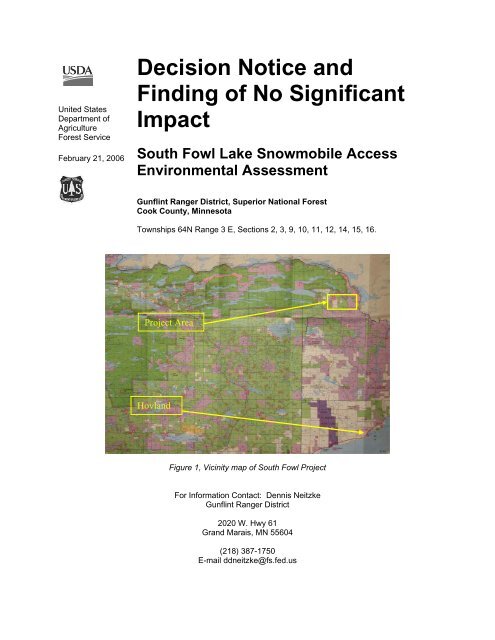
Figure 1, Vicinity map <strong>of</strong> <strong>South</strong> <strong>Fowl</strong> Project<br />
For Information Contact: Dennis Neitzke<br />
Gunflint Ranger District<br />
2020 W. Hwy 61<br />
Gr<strong>and</strong> Marais, MN 55604<br />
(218) 387-1750<br />
E-mail ddneitzke@fs.fed.us
TABLE OF CONTENTS<br />
INTRODUCTION......................................................................................................................... 3<br />
DECISION................................................................................................................................... 11<br />
REASONS FOR THE DECISION............................................................................................ 15<br />
ALTERNATIVES CONSIDERED IN DETAIL...................................................................... 25<br />
CONSISTENCY WITH NATIONAL FOREST MANAGEMENT ACT THE<br />
FOREST PLAN AND OTHER LAWS..................................................................................... 27<br />
FINDING OF NO SIGNIFICANT IMPACT........................................................................... 30<br />
PROJECT IMPLEMENTATION............................................................................................. 40<br />
REFERENCES CITED.............................................................................................................. 40<br />
APPEAL RIGHTS...................................................................................................................... 41<br />
APPENDIX A – Photo Series <strong>of</strong> <strong>Decision</strong><br />
APPENDIX B – Design Elements, Mitigation Measures, Monitoring<br />
APPENDIX C – Map<br />
APPENDIX D – Response to Comments<br />
The U.S. Department <strong>of</strong> Agriculture (USDA) prohibits discrimination in all its programs <strong>and</strong><br />
activities on the basis <strong>of</strong> race, color, national origin, gender, religion, age, disability, political<br />
beliefs, sexual orientation, or marital or family status. (<strong>No</strong>t all prohibited bases apply to all<br />
programs.) Persons with disabilities who require alternative means for communication <strong>of</strong> program<br />
information (Braille, large print, audiotape, etc.) should contact USDA's TARGET Center at (202)<br />
720-2600 (voice <strong>and</strong> TDD). To file a complaint <strong>of</strong> discrimination, write USDA, Director, Office <strong>of</strong><br />
Civil Rights, Room 326-W, Whitten Building, 14th <strong>and</strong> Independence Avenue, SW, Washington,<br />
DC 20250-9410 or call (202) 720-5964 (voice <strong>and</strong> TDD). USDA is an equal opportunity provider<br />
<strong>and</strong> employer.
INTRODUCTION<br />
This document describes the decision I have made regarding safe snowmobile access to<br />
<strong>South</strong> <strong>Fowl</strong> Lake from the McFarl<strong>and</strong> Lake area, on the Superior National Forest. This<br />
document also describes my reasons for the decision, <strong>and</strong> finding that an environmental<br />
impact statement is not needed. This finding is in accordance with the National<br />
Environmental Policy Act, other laws, regulation <strong>and</strong> policy. This decision <strong>and</strong> finding<br />
are based on my knowledge <strong>of</strong> the Upper Arrowhead Trail (Cook County #16) area, my<br />
review <strong>of</strong> the <strong>South</strong> <strong>Fowl</strong> Lake Snowmobile Access Environmental Assessment (S. <strong>Fowl</strong><br />
EA), the Biological Evaluation, the project record <strong>and</strong> the 2004 Superior National Forest<br />
L<strong>and</strong> <strong>and</strong> Resource Management Plan (Forest Plan).<br />
The <strong>South</strong> <strong>Fowl</strong> Snowmobile Access project has been one <strong>of</strong> the more interesting in my<br />
career. It is something that should have been dealt with long ago, however it wasn’t. It is<br />
a fairly simple proposal, however it has stirred personal emotion that has been decades in<br />
building. It seemed the more I worked with the public to find a common solution, the<br />
more polarized they became. This decision will be fully welcomed <strong>and</strong> completely<br />
rejected, absolutely right <strong>and</strong> horribly wrong. A portion <strong>of</strong> the public will cheer, the rest<br />
will jeer. Some will claim victory, others will cry foul. To help underst<strong>and</strong> why we are<br />
where we are, I am providing some background.<br />
Why here <strong>and</strong> why now?<br />
The genesis <strong>of</strong> this project began in 2003 when an existing snowmobile trail, sometimes<br />
known as the “Tilbury Trail”, was brought to my attention. I had decided to step up<br />
winter patrol <strong>of</strong> the Boundary Waters Canoe Area Wilderness (BWCAW) to ensure<br />
integrity <strong>of</strong> the wilderness during the <strong>of</strong>f peak months. Through our patrol, a member <strong>of</strong><br />
the public mentioned the existence <strong>of</strong> a trail that traveled across Royal Lake. During<br />
inspection, it was determined the trail crossed a corner <strong>of</strong> the Wilderness <strong>and</strong> therefore<br />
would need to be closed.<br />
Figure 2. Map showing historic Tilbury Trail in relation to Royal Lake<br />
Tilbury Trail connected McFarl<strong>and</strong> Lake with <strong>South</strong> <strong>Fowl</strong> Lake (see Figure 1). It<br />
should be pointed out here that <strong>South</strong> <strong>Fowl</strong> Lake is the eastern most lake in a chain <strong>of</strong><br />
3
order lakes that creates the common border with Canada. Although the 1978 BWCAW<br />
Act (PL 95-495) permits some very limited motorboat <strong>and</strong> snowmobile use within the<br />
Wilderness, those lakes <strong>and</strong> routes are specifically named in the Act <strong>and</strong> according to PL<br />
95-495, Sec. 4 (i) “…no other motor use is permitted..” within the boundaries <strong>of</strong> the<br />
Wilderness. Appropriate application <strong>of</strong> Federal Law caused me to close <strong>of</strong> the trail.<br />
However, along with closing the trail, I took the time to further explore the history <strong>of</strong> the<br />
trail, the history <strong>of</strong> the usage <strong>of</strong> lakes in this area <strong>and</strong> the history <strong>of</strong> wilderness legislation.<br />
I walked the Tilbury Trail <strong>and</strong> studied aerial photos <strong>of</strong> the vicinity. I snowmobiled<br />
<strong>South</strong> <strong>Fowl</strong> Road <strong>and</strong> the rough trail into <strong>South</strong> <strong>Fowl</strong> Lake. Potential resolutions or<br />
alternatives involved use <strong>of</strong> l<strong>and</strong>s managed by Minnesota Department <strong>of</strong> Natural<br />
Resources <strong>and</strong> Arrowhead Trail managed by Cook County. Therefore I involved<br />
members <strong>of</strong> these governments throughout the analysis <strong>of</strong> this project. Early in this<br />
analysis I also communicated with the 1854 Authority <strong>and</strong> received their support for a<br />
replacement trail.<br />
I found that snowmobiling is legal <strong>and</strong> common around McFarl<strong>and</strong> Lake. It is legal <strong>and</strong><br />
common on <strong>South</strong> <strong>Fowl</strong> <strong>and</strong> <strong>No</strong>rth <strong>Fowl</strong> on both sides <strong>of</strong> the U.S./Canada border. For<br />
those lakes west <strong>of</strong> <strong>No</strong>rth <strong>Fowl</strong>, snowmobiling is legal <strong>and</strong> common in Canada for<br />
citizens <strong>of</strong> both countries.<br />
A search <strong>of</strong> 1961 aerial photos shows what appears to be a winter logging trail that<br />
accessed the Royal River, west <strong>of</strong> Royal Lake. A review <strong>of</strong> 1970 aerial photos (Figure 3)<br />
indicates that change had occurred. A small timber sale, apparently logged by a fellow<br />
named Verl Tilbury (Rabold, 2006), had taken place in the vicinity <strong>of</strong> the cliffs west <strong>of</strong><br />
Royal Lake. A close look at the photo reveals what appears to be a skid trail running the<br />
length <strong>of</strong> the sale area <strong>and</strong> a very narrow trail extended a couple hundred feet to the<br />
Royal Lake wetl<strong>and</strong>s. This demonstrates the Tilbury Trail was predominantly established<br />
by logging <strong>and</strong> it predated the establishment <strong>of</strong> the BWCAW (’78 Act) in that vicinity.<br />
4
Logged Area Logging trail ends here<br />
Figure 3. 1970 aerial photo showing logged area. Yellow line shows logging trail<br />
I further found that the trail from <strong>South</strong> <strong>Fowl</strong> Road to <strong>South</strong> <strong>Fowl</strong> Lake is very steep<br />
(Figure 4), narrow <strong>and</strong> rocky such that only one snowmobile at a time could successfully<br />
negotiate the trail. The problem was that a snowmobile attempting to go uphill had to<br />
build up some speed in order to make it up the <strong>of</strong>ten icy hill. During the uphill run a<br />
snowmobiler must “hope” no one was coming downhill. Negotiating this trail is a highly<br />
unsafe practice, especially with ice fishing or other equipment in tow.<br />
I realized I had the option <strong>of</strong> doing nothing in terms <strong>of</strong> further snowmobile access to<br />
<strong>South</strong> <strong>Fowl</strong> Lake. <strong>No</strong> action would force snowmobilers to use Arrowhead Trail to <strong>South</strong><br />
<strong>Fowl</strong> Road, then the steep trail from <strong>South</strong> <strong>Fowl</strong> Road to the Lake. Three considerations<br />
weighed on me regarding that route.<br />
1. Arrowhead Trail is steep as it departs McFarl<strong>and</strong> Lake, creating a particular<br />
hazard for low pr<strong>of</strong>ile snowmobiles attempting to be seen by oncoming highway<br />
vehicles.<br />
2. The Arrowhead Trail is a well traveled County Road <strong>and</strong> the Forest Service has a<br />
long st<strong>and</strong>ing policy <strong>of</strong> creating separation between highway vehicles <strong>and</strong><br />
snowmobiles.<br />
3. The steep unnamed trail down to <strong>South</strong> <strong>Fowl</strong> Lake cannot be negotiated by two<br />
way traffic (Figure 4).<br />
As a result <strong>of</strong> these concerns, I met with <strong>of</strong>ficials from the Minnesota Department <strong>of</strong><br />
Natural Resources <strong>and</strong> Cook County Board <strong>of</strong> Commissioners to develop a proposal that<br />
would provide safe access from the McFarl<strong>and</strong> Lake vicinity to <strong>South</strong> <strong>Fowl</strong> Lake.<br />
5
Figure 4. Photo showing steep hill is Section 11; trail is narrow then descends steeply.<br />
<strong>No</strong>w, it should be relatively simple; “to create safe access”. However public involvement<br />
throughout this assessment has been interesting to say the least. The number <strong>of</strong> people<br />
commenting on this project is over one hundred times that <strong>of</strong> another 14.5 mile<br />
snowmobile trail project that is considerably more complex (over 540 comments on this<br />
assessment vs. 5 comments on the more complex assessment). Further, comments on this<br />
project have been much more inflammatory <strong>and</strong> personal in nature than on similar<br />
projects. This project has fanned smoldering emotions over management <strong>of</strong> the Superior<br />
National Forest <strong>and</strong> the Boundary Waters that have roots in the early 1900’s. It is worth<br />
underst<strong>and</strong>ing some <strong>of</strong> the passionate history that surrounds both the <strong>South</strong> <strong>Fowl</strong> area <strong>and</strong><br />
the BWCAW.<br />
Historical perspective, Superior National Forest <strong>and</strong> the BWCAW.<br />
Most national forests in the eastern United States were created to re-establish forests on<br />
l<strong>and</strong>s that were cut over, burned, farmed <strong>and</strong> basically worn out. They were described as<br />
6
the “L<strong>and</strong>s <strong>No</strong>body Wanted”. This was only partly true for northern Minnesota. The<br />
lake country near the border still had virgin forests <strong>and</strong> pristine waters, <strong>and</strong> it had active<br />
logging. President Theodore Roosevelt established the Superior National Forest in 1909<br />
recognizing the natural beauty <strong>of</strong> northeastern Minnesota. However, in the 1920s plans<br />
were being formed to construct a series <strong>of</strong> dams for the purposes <strong>of</strong> storing water to<br />
power hydroelectric plants down stream. In the same time frame a resort industry began<br />
to thrive throughout much <strong>of</strong> what is now the Wilderness. The love <strong>of</strong> this area along<br />
with increasing use <strong>and</strong> development led to conflicting dem<strong>and</strong>s giving birth to a forest<br />
surrounded in controversy.<br />
To provide a measure <strong>of</strong> balance against development, Secretary <strong>of</strong> Agriculture Jardine,<br />
in 1926 set aside 1000 square miles <strong>of</strong> the Superior National Forest for no further road<br />
building. However there were no established boundaries for his set aside (Legislative<br />
History PL 95-495).<br />
Another step was taken in 1930 when the Shipstead Newton <strong>No</strong>lan Act was passed to<br />
protect the lakes area from hydroelectric dam construction both inside <strong>and</strong> outside <strong>of</strong> the<br />
area protected (Leg. His. PL 95-495).<br />
By 1949, Ely, Minnesota had become the largest fresh water seaplane base on the<br />
continent serving some 41 resorts within the interior <strong>of</strong> the area set aside by Secretary<br />
Jardine. It was in 1949 that President Truman established an airspace reservation over<br />
the roadless area through an executive order, ending the l<strong>and</strong>ing or low level flight (4,000<br />
ASL) <strong>of</strong> airplanes in the roadless area by the general public <strong>and</strong> private l<strong>and</strong>owners. This<br />
order was litigated (all the way to the Supreme Court), <strong>and</strong> prompted l<strong>and</strong>owners to<br />
consider the sale <strong>of</strong> their property (USDA Forest Service, 1993).<br />
In 1964, the Wilderness Act provided formal delineation between l<strong>and</strong>s to be managed as<br />
wilderness (Boundary Waters Canoe Area, BWCA) <strong>and</strong> those as general forest.<br />
However, the ‘64 Act still permitted logging, snowmobiling <strong>and</strong> motorboats within the<br />
BWCA. The Superior National Forest finalized a management plan for the BWCA in<br />
1965 following the parameters <strong>of</strong> the ’64 Act. Roughly 600,000 acres were planned for<br />
non-motorized use <strong>and</strong> 400,000 acres were semi-primitive use, including logging,<br />
snowmobiles <strong>and</strong> motorboats (Leg. His. PL 95-495).<br />
In the 1970’s the US Congress debated further legislation to prescribe management for<br />
Minnesota’s national forest <strong>and</strong> wilderness. Minnesota Representative Frazer described<br />
the parameters for managing the BWCA as “…frustratingly ambiguous…” under the ’64<br />
Wilderness Act. Therefore in January, 1977 he introduced HR2820 for the purposes <strong>of</strong><br />
“…seeking to reduce or eliminate the ambiguity <strong>of</strong> management within the wilderness…”<br />
His bill would add roughly 35,000 acres <strong>and</strong> eliminate motorized use (Leg. His. PL 95-<br />
495).<br />
However Congressman Oberstar (Minnesota) also introduced a bill, HR 8722 to rectify<br />
ambiguity. His bill would place roughly 701,000 acres as “pure wilderness” along with<br />
approximately 412,000 as a National Recreation Area, allowing some motorized use.<br />
7
Shortly after, Representative Burton (California) introduced HR 12250 which would add<br />
35,000 acres to the BWCA <strong>and</strong> 220,000 acres to be managed as National Recreation Area<br />
for those parcels between the wilderness units. The final bill to come out <strong>of</strong> House <strong>and</strong><br />
Senate conference established the BWCAW at around 1,100,000 acres. The new<br />
boundaries were mapped out <strong>and</strong> a legal description was drawn to follow that map (Leg.<br />
His. PL 95-495). There was no area defined as National Recreation Area in the final bill.<br />
Congress debated the Act for three years <strong>and</strong> the deadlock was only broken when<br />
representatives <strong>of</strong> groups with differing views met in a marathon negotiating session<br />
where a compromise agreement was reached. Interestingly, with the passage <strong>of</strong> the ’78<br />
Act, the public controversy did not come to an end. There were loud protests including<br />
public “lockouts” at District <strong>of</strong>fices. Demonstrations took place on April 14, 1978 when<br />
an estimated 1,000 people protested by reading an eviction notice to the Gunflint District<br />
Ranger while the City <strong>of</strong> Gr<strong>and</strong> Marais cut the electricity to the District Office (Cook<br />
County News Herald, 2006). <strong>No</strong>t everyone easily accepted the decisions made by<br />
Congress.<br />
One could ask the question, “Did the ’78 Act reduce or eliminate ambiguity?” The<br />
answer should be “Yes”. While Congress did not totally eliminate motorized use or<br />
create a “pure” wilderness, they were specific <strong>and</strong> clear with their directions. Congress<br />
clearly defined the boundaries for the new BWCAW. Logging was eliminated from<br />
within the Wilderness. The law contained provisions for motorboats on specifically<br />
named lakes <strong>and</strong> very limited snowmobiling on specifically named routes. Otherwise<br />
motor use in the Wilderness was prohibited.<br />
Interestingly, one could also ask the question, “Did the ’78 Act reduce or eliminate<br />
ambiguity outside the BWCAW?” Again the answer should be “Yes”.<br />
• First, Congress provided specific direction in the Wilderness Act <strong>of</strong> 1964 under<br />
Section 2 (a) “…<strong>and</strong> no Federal l<strong>and</strong>s shall be designated as “wilderness areas”<br />
except as provided for in this Act or by a subsequent Act.”<br />
• Second, over the years Congress has provided guidance for managing National<br />
Forest System l<strong>and</strong>s through a series <strong>of</strong> Laws, notably the “Organic Act”, the<br />
Multiple-Use Sustained-Yield Act”, the “Endangered Species Act”, the Resources<br />
Planning Act (RPA) <strong>and</strong> the “National Forest Management Act” (NFMA).<br />
Forest Plans are prepared under the auspices <strong>of</strong> these Acts to provide strategic<br />
management <strong>of</strong> each National Forest.<br />
• Third, the 1964 Wilderness Act provided clear separation between management<br />
strategies for wilderness <strong>and</strong> non-wilderness, although the BWCA was somewhat<br />
muddled given provisions that allowed exceptions (prior to 1978 such as logging,<br />
snowmobiling <strong>and</strong> motor boating where found within the BWCA).<br />
• Fourth, the ’78 Act clearly established the new Wilderness boundaries <strong>and</strong> ended<br />
all logging, most <strong>of</strong> the snowmobiling <strong>and</strong> dramatically reduced motor boat use<br />
within the BWCAW. The same Act contained language that directed the Forest<br />
Service (through the Secretary <strong>of</strong> Agriculture) to provide additional opportunities<br />
for those uses outside the newly established Wilderness boundaries (i.e. Section<br />
18(a).<br />
8
Congress clearly intended that l<strong>and</strong>s within designated Wilderness boundaries be<br />
managed under specific guidance provided by specific wilderness legislation. Congress<br />
also clearly intended that l<strong>and</strong>s outside designated Wilderness be managed for purposes<br />
other than Wilderness.<br />
Historical perspective, Tilbury Trail<br />
As mentioned, the Tilbury Trail was in place <strong>and</strong> can be located on aerial photos as early<br />
as 1970. During the writing <strong>of</strong> the ’78 Act, Royal Lake <strong>and</strong> Royal River were both<br />
included in the exp<strong>and</strong>ed boundaries for the new BWCAW. With the <strong>of</strong>ficial boundary<br />
placed at 400 feet above the normal high water mark <strong>of</strong> the River <strong>and</strong> Lake, the Tilbury<br />
Trail was now placed inside the Wilderness <strong>and</strong> motorized use <strong>of</strong> the trail was no longer<br />
legal.<br />
There is some question as to how well the boundaries were displayed <strong>and</strong> communicated.<br />
Maps show the boundary on Royal River <strong>and</strong> Lake. Some thought that if they skirted the<br />
lake, their use would be legal. Although at the same time, there was use through the<br />
middle <strong>of</strong> Royal Lake, which was clearly not legal.<br />
In the early ‘90s Cook County petitioned the Gunflint Ranger District for a combined<br />
ATV <strong>and</strong> snowmobile trail to <strong>South</strong> <strong>Fowl</strong> Lake, which was denied. The record does not<br />
indicate if the County was referencing the Tilbury Trail in their petition (it is clear that<br />
the Tilbury Trail was not adequate for ATV use). At any rate, it appears that no specific<br />
action was taken to close the Tilbury Trail.<br />
<strong>No</strong>w with a proposal for safe snowmobile access into <strong>South</strong> <strong>Fowl</strong> Lake, the debate over<br />
proper management <strong>of</strong> the Superior National Forest continues. The Tilbury Trail is no<br />
longer an option. Every option considered in the <strong>South</strong> <strong>Fowl</strong> Access EA locates a new<br />
trail outside the wilderness. <strong>No</strong> motorized use <strong>of</strong> the BWCAW is analyzed or will it be<br />
authorized. However, the debate over what is “right” continues with all the fervor the<br />
Superior National Forest <strong>and</strong> the BWCAW has known. Amidst the passion <strong>and</strong> debate, it<br />
has been <strong>and</strong> will continue to be my position to follow law, regulation <strong>and</strong> Forest Service<br />
policy.<br />
Project Vicinity<br />
Proposed trail alternatives are located in the south halves <strong>of</strong> Sections 2 <strong>and</strong> 3 <strong>and</strong> the full<br />
Section 9, 10, 11, 12, 13, 14, 15, <strong>and</strong> 16 <strong>of</strong> T. 65 N., R.3 E.: the area between <strong>and</strong> south<br />
<strong>of</strong> McFarl<strong>and</strong> <strong>and</strong> <strong>South</strong> <strong>Fowl</strong> Lakes. All alternatives are within Superior National Forest<br />
L<strong>and</strong> <strong>and</strong> Management Plan (Forest Plan) management areas (MA) 10.2 General Forest<br />
Longer Rotation. The project is entirely within Cook County, Minnesota. L<strong>and</strong>s<br />
involved with these alternatives include National Forest system l<strong>and</strong>s, Gr<strong>and</strong> Portage<br />
State Forest <strong>and</strong> Cook County Arrowhead Trail. Since alternatives cross l<strong>and</strong>s or roads<br />
managed by the State Department <strong>of</strong> Natural Resources (DNR) <strong>and</strong> Cook County Road<br />
Commission, this decision was made with full consultation with DNR Officials <strong>and</strong> the<br />
Cook County Board <strong>of</strong> Commissioners (See map in Appendix C).<br />
9
Purpose <strong>of</strong> <strong>and</strong> Need for Action<br />
I have considered several factors when thinking through this project <strong>and</strong> why it needs to<br />
be done. I have not found any absolute legal requirement that the Forest Service provide<br />
further access to the <strong>Fowl</strong> Lakes. However, as mentioned above, snowmobiling is legal<br />
on both <strong>Fowl</strong> Lakes <strong>and</strong> on the Canadian side <strong>of</strong> the border lakes to the west. There is a<br />
section <strong>of</strong> the ’78 Act that did weigh into my thinking.<br />
Sec. 18. (a) EXPANSION OF RECREATION PROGRAMS. The Secretary is<br />
authorized <strong>and</strong> directed to expedite <strong>and</strong> intensify the program <strong>of</strong> dispersed<br />
outdoor recreation development on the Superior National Forest outside the<br />
Boundary Waters Canoe Area Wilderness, as designated by this Act. The<br />
Secretary shall consider in such new program development the need for the<br />
following: additional snowmobile trails, particularly those now planned or under<br />
construction; remote campsites on lightly developed lakes; <strong>and</strong> lake access sites<br />
<strong>and</strong> parking facilities to provide motorized recreation experiences similar to those<br />
previously available in the Boundary Waters Canoe Area.<br />
While this does not necessarily compel a particular action in a particular place, in my<br />
mind Congress encouraged the Forest Service to take a hard look at improving facilities<br />
outside the BWCAW especially when removing similar facilities from within the<br />
Wilderness. Also as mentioned, doing nothing would leave an untenable situation with<br />
the narrow trail from <strong>South</strong> <strong>Fowl</strong> Road to the Lake <strong>and</strong> the steep hill on the Arrowhead<br />
Trail as it heads south <strong>of</strong> McFarl<strong>and</strong> Lake. Therefore, I have determined that action is<br />
appropriate.<br />
The purpose <strong>of</strong> this project is to develop safe, adequate <strong>and</strong> legal snowmobile access<br />
from the McFarl<strong>and</strong> Lake area to <strong>South</strong> <strong>Fowl</strong> Lake on the Gunflint Ranger District,<br />
Superior National Forest. This trail would provide public access to the border lakes<br />
without threatening private l<strong>and</strong> or damaging the wilderness resources. A route<br />
designated by the Forest Service, in cooperation with the Minnesota DNR <strong>and</strong> Cook<br />
County, better h<strong>and</strong>les existing use on a single preferred route away from other crosscountry<br />
alternatives.<br />
Forest Plan Direction<br />
The National Forest Management Act <strong>of</strong> 1976 (NFMA) amended the Resources Planning<br />
Act <strong>of</strong> 1974 (RPA) to require each National Forest prepare, maintain <strong>and</strong> as appropriate<br />
revise a L<strong>and</strong> Management Plan (PL 93-378 sec 6(a)). Pursuant to PL 93-378 Sec 6(e)<br />
Forest Plans shall provide for multiple use <strong>and</strong> Sustained yield <strong>of</strong> product <strong>and</strong> services<br />
obtained therefrom in accordance with the Multiple-Use Sustained- Yield Act <strong>of</strong> 1960<br />
<strong>and</strong>, in particular, include coordination <strong>of</strong> outdoor recreation, range, timber, watershed,<br />
wildlife <strong>and</strong> fish, <strong>and</strong> wilderness.<br />
In compliance with NFMA the Superior National Forest conducted an environmental<br />
impact statement (EIS) <strong>and</strong> prepared a L<strong>and</strong> <strong>and</strong> Resource Management Plan (Forest<br />
Plan) for which a Record <strong>of</strong> <strong>Decision</strong> was signed in 1986. Those portions <strong>of</strong> the Forest<br />
Plan pertaining to wilderness management were revised, an EIS was prepared <strong>and</strong> the<br />
Forest Plan was amended in 1993. Further, the remainder <strong>of</strong> the plan (outside the<br />
10
BWCAW) was revised following the completion <strong>of</strong> an EIS with the record <strong>of</strong> decision<br />
signed in August, 2004.<br />
The environmental assessment (EA) for this project is tiered to the Final Environmental<br />
<strong>Impact</strong> Statement (FEIS) for the Superior National Forest Revised Forest L<strong>and</strong> <strong>and</strong><br />
Resource Management Plan dated August, 2004, as permitted by 40 CFR 1502.2. The<br />
Forest Plan established multiple use goals, objectives, st<strong>and</strong>ards <strong>and</strong> guides for managing<br />
the Forest. Proposed alternatives have been evaluated in terms <strong>of</strong> guidance provided by<br />
the Plan.<br />
The management area (MA) involved as designated by the Superior Forest Plan is<br />
MA.10.2 General Forest Longer Rotation.<br />
All <strong>of</strong> the trail construction alternatives are located within MA 10.2 (pg 3-10).<br />
Emphases for l<strong>and</strong> <strong>and</strong> resource conditions are to provide a wide variety <strong>of</strong> goods <strong>and</strong><br />
services that include scenic quality, recreation opportunities, <strong>and</strong> access to those<br />
opportunities. Interactions between users may be moderate to high, with evidence <strong>of</strong><br />
other users prevalent. Conventional motorized use is allowed <strong>and</strong> incorporated into<br />
construction st<strong>and</strong>ards <strong>and</strong> design <strong>of</strong> facilities. Management activities are directed to<br />
move the area toward Roaded Natural ROS (Recreation Opportunity Spectrum)<br />
characteristics. Open roads provide access to resources <strong>and</strong> roaded recreational<br />
opportunities. The setting for MA 10.2 is described as where recreation use <strong>and</strong>/or lake<br />
density is high, or the potential for recreation use is high. Snowmobile trails <strong>and</strong> lake<br />
access may be provided in this area.<br />
DECISION<br />
I have given careful consideration to the resources affected; the guidance provided by<br />
law, regulation <strong>and</strong> policy as well as the public discourse that has resulted from this<br />
proposal. My decision is somewhat different than what would normally be made for a<br />
proposal. I have decided to approve both alternatives 2 <strong>and</strong> 4 with some caveats. Only<br />
one route may be constructed <strong>and</strong> used at a time. Alternative 2 (the northern route) is<br />
approved for construction under the given criteria. If at some time, a decision is made to<br />
use Alternative 4, then the northern route must be ab<strong>and</strong>oned <strong>and</strong> obliterated.<br />
I have walked the routes for alternative 2 <strong>and</strong> 4 several times, a few <strong>of</strong> those times with<br />
our civil engineering technician <strong>and</strong> our recreation specialist to discuss construction<br />
techniques <strong>and</strong> impacts. I have observed soil types to estimate potential impacts. I’ve<br />
looked at the proposed routes in both summer <strong>and</strong> winter to estimate effects to the<br />
BWCAW. I’ve mentally constructed the trail to estimate the impacts to trees, vegetation,<br />
scenery, various wildlife species, as well as the general l<strong>and</strong> forms in the vicinity (see<br />
Appendix A). I have looked into the history <strong>of</strong> the area <strong>and</strong> read all the public comments<br />
on this proposal. My decision is based on this knowledge <strong>of</strong> the project area <strong>and</strong> a review<br />
<strong>of</strong> the <strong>South</strong> <strong>Fowl</strong> Lake Snowmobile Access Environmental Assessment, the Biological<br />
Evaluation, the project file, law, regulation, policy <strong>and</strong> the Forest Plan.<br />
11
Alternative 2 will be a slow speed, somewhat rough trail that shall only be used by<br />
snowmobiles, typical <strong>of</strong> those in current use (see figure 5). All terrain vehicles (ATVs)<br />
will not be permitted. Appendix A includes a series <strong>of</strong> photos demonstrating route<br />
conditions. This decision includes the following actions:<br />
Clearing vegetation (tree <strong>and</strong> shrub, primarily with chainsaws) on a corridor 8-10<br />
feet wide <strong>and</strong> approximately 2.2 miles long. Emphasis will be on putting winding<br />
trail through brushy areas along the route <strong>and</strong> cutting as few trees as possible.<br />
Only minimal use <strong>of</strong> heavy equipment will be used. There is a short<br />
(approximately 100-150 feet) slope near the center <strong>of</strong> the north section line <strong>of</strong><br />
section 10 (NE1/4, NW1/4, NE1/4, Sec 10) where the route will need to be cut into<br />
the side slope.<br />
There is a short section toward the middle <strong>of</strong> the route (approximately 100-150<br />
feet) where some rock may have to be moved from the treadway. For this section,<br />
logs may be used to help level the trail, but will generally be no more than 12<br />
inches high.<br />
Signs will be placed to guide <strong>and</strong> regulate snowmobile traffic as well as warn other<br />
traffic at trail/road intersections.<br />
The old Tilbury Trail is <strong>of</strong>ficially closed, however to ensure success <strong>of</strong> this<br />
decision, physical closure will be implemented with this decision. Rocks <strong>and</strong><br />
natural debris will be placed in the trail to block use <strong>of</strong> the trail. Heavy equipment<br />
such as a Bobcat or rubber-tired front-end loader may be used to place the rocks<br />
<strong>and</strong> stumps.<br />
For the purpose <strong>of</strong> this decision, a snowmobile is defined using the Superior<br />
National Forest Plan definition <strong>of</strong> being self propelled <strong>and</strong> steered by skis or<br />
runners (see figure 5). This trail will be constructed for snow machines that fit that<br />
definition <strong>and</strong> that are designed solely for the purpose <strong>of</strong> snow travel. Since<br />
technology is quickly advancing, it is difficult to predict what machinery might be<br />
developed for snow travel. Future new <strong>and</strong> different types <strong>of</strong> machines are not<br />
approved for use on this trail. For example, that would include vehicles that have<br />
two or four tracks designed for both propulsion <strong>and</strong> steering.<br />
Barriers <strong>and</strong> gates will be installed to reduce opportunities for illegal OHV use <strong>of</strong><br />
the Border Route Trail <strong>and</strong> other federal l<strong>and</strong>s.<br />
Initiate a Forest Supervisor’s closure order for motorized use other than<br />
snowmobiles on the federal portions <strong>of</strong> the trail.<br />
<strong>No</strong> mechanical grooming would be permitted for this alternative.<br />
Monitoring will be done by the Forest Service <strong>and</strong> potentially a cooperating group<br />
<strong>of</strong> citizens to assess any illegal use (particularly any ATV or OHV, as well as any<br />
snowmobiles entering the Wilderness) <strong>of</strong> this trail, to ensure erosion <strong>and</strong> sediment<br />
control measures are effective <strong>and</strong> to determine the presence or introduction <strong>of</strong><br />
noxious non-native invasive plants.<br />
I am also approving h<strong>and</strong> planting <strong>of</strong> a variety <strong>of</strong> tree species in <strong>and</strong> around the trail<br />
route, particularly on the bench area between the upper <strong>and</strong> lower cliffs. There has<br />
been considerable natural mortality <strong>of</strong> trees in this area that are being replaced by<br />
brush (primarily mountain maple). The objective would be to reestablish trees in<br />
this area using native species (such as cedar, yellow birch, red <strong>and</strong> white pine).<br />
12
I am also approving the closure <strong>of</strong> Wooly’s Bluff Road to OHV <strong>and</strong> snowmobile<br />
use.<br />
Figure 5. Photo <strong>of</strong> a typical snowmobile in use today, generally a single rear track<br />
for propulsion <strong>and</strong> two front skis for steering. Machines with two or four tracks<br />
that are used for both propulsion <strong>and</strong> steering are not approved for use on this<br />
trail.<br />
As mentioned above, there will be only one route in use, either alternative 2 or 4. I am<br />
placing caveats with this decision that will allow flexibility to adapt to changing<br />
conditions. If there is cause to do so, the north route will be closed <strong>and</strong> obliterated <strong>and</strong><br />
then Alternative 4 will be constructed <strong>and</strong> used. To ensure successful implementation <strong>of</strong><br />
this decision, the Forest Service will continue to collaborate with Cook County<br />
Commissioners <strong>and</strong> Minnesota State DNR. Conditions indicating a need for change are:<br />
If at some point in the future, the State, County <strong>and</strong> Forest Service wish to put in a<br />
connecting system <strong>of</strong> snowmobile trails from the State grant in aid trails to the<br />
McFarl<strong>and</strong> or <strong>South</strong> <strong>Fowl</strong> Lakes area, then Alternative 2 would be closed <strong>and</strong><br />
Alterative 4 be constructed.<br />
If the Forest Service has determined that reasonable attempts to close the north<br />
route to OHVs are not effective, the trail will be closed <strong>and</strong> Alternative 4<br />
constructed (i.e. riders are cutting paths around closure devises or monitoring<br />
determines that OHV incursions are being made on the trail).<br />
If the BWCAW is physically breached by snowmobiles from Alternative 2 or OHV<br />
cannot be controlled on Alternative 2, this route will be closed <strong>and</strong> Alternative 4<br />
constructed.<br />
If analysis by the Forest Service <strong>and</strong> the State shows that use by snowmobiles <strong>of</strong><br />
the northern route exceeds its capability, it will be closed <strong>and</strong> rerouted to<br />
Alternative 4. The measure to determine this will be excessive resource damage or<br />
excessive interaction between snowmobiles.<br />
13
Trail closure st<strong>and</strong>ards <strong>and</strong> techniques are as follows:<br />
o The short hill leading to the bench area will be reshaped to its original<br />
contour <strong>and</strong> revegetated with species typical <strong>of</strong> the area.<br />
o Small trees (up to eight feet tall) will be transplanted to restore the<br />
affected area on the slope.<br />
o Transplanted trees will be added to the visible area from any road or trail<br />
intersection.<br />
o The segment overlapping the old Tilbury Trail will be obliterated with<br />
rocks, stumps <strong>and</strong> natural debris to prevent motorized incursion.<br />
If I, or any <strong>of</strong> my successors, determine that any one <strong>of</strong> the above criteria is met, that<br />
would trigger a switch from Alternative 2 to Alternative 4. Should the time come that the<br />
northern route will be closed; it will be done with physical measures similar to the<br />
Tilbury Trail. If conditions warrant a change, I am approving Alternative 4 for<br />
construction. Alternative 4 will be more <strong>of</strong> a st<strong>and</strong>ard design trail that includes the<br />
following actions:<br />
Clearing vegetation (tree <strong>and</strong> shrub, primarily with chainsaws) on a corridor 12-14<br />
feet wide <strong>and</strong> approximately 1.9 miles long from McFarl<strong>and</strong> Lake to the junction <strong>of</strong><br />
<strong>South</strong> <strong>Fowl</strong> Road.<br />
Heavy equipment will be used to construct a 12 foot running surface for<br />
snowmobiles. There is a short exception to this; the new segment <strong>of</strong> trail<br />
constructed from Wooly’s Bluff Road through the woods to an intersection with<br />
Arrowhead Trail would be done with minimal heavy equipment use. That segment<br />
will be slower speed trail constructed by cutting as few trees as possible.<br />
The <strong>South</strong> <strong>Fowl</strong> Road would be used for the trail <strong>and</strong> during the winters when there<br />
might be logging <strong>and</strong> the road is plowed, safety signs will be used.<br />
The trail for the last 0.84 miles from <strong>South</strong> <strong>Fowl</strong> Road to the Lake would be<br />
widened to 12 to 14 feet similar to the section on the shoulder <strong>of</strong> Arrowhead Trail.<br />
The steep section <strong>of</strong> trail in section 11 will be constructed with switchbacks<br />
winding down the hill to create a trail wide enough for two sleds to pass each other,<br />
one going up <strong>and</strong> one going down. It will also have a design speed such that two<br />
snowmobilers can pass each other with reasonable safety.<br />
The parking area at the intersection <strong>of</strong> <strong>South</strong> <strong>Fowl</strong> <strong>and</strong> Arrowhead Trail will be<br />
bladed <strong>and</strong> resurfaced with crushed gravel.<br />
Signs will be placed to guide <strong>and</strong> regulate snowmobile traffic as well as warn other<br />
traffic at trail/road intersections.<br />
Barriers <strong>and</strong> gates will be installed to reduce opportunities for illegal OHV use <strong>of</strong><br />
the Border Route Trail <strong>and</strong> other federal l<strong>and</strong>s.<br />
Monitoring will be done by the Forest Service <strong>and</strong> potentially a cooperating group<br />
<strong>of</strong> citizens to assess any OHV use <strong>of</strong> this trail, to ensure erosion <strong>and</strong> sediment<br />
control measures are effective <strong>and</strong> to determine the presence or introduction <strong>of</strong><br />
noxious non-native invasive plants.<br />
If determined to be a part <strong>of</strong> the grant in aid trail system, this alternative could be<br />
mechanically groomed.<br />
14
Appendix A includes photos <strong>and</strong> discussion <strong>of</strong> trail layout <strong>and</strong> design. Specific design<br />
criteria <strong>and</strong> monitoring actions that are included with this decision are listed in Appendix<br />
B.<br />
All acreages <strong>and</strong> miles stated in the <strong>Decision</strong> <strong><strong>No</strong>tice</strong> <strong>and</strong> <strong>South</strong> <strong>Fowl</strong> Lake Access Area<br />
EA are pr<strong>of</strong>essional judgments based on computer analysis <strong>of</strong> G.P.S. locations. Small<br />
differences in actual on-the-ground harvest unit acreages <strong>and</strong> road <strong>and</strong> trail distances are<br />
possible.<br />
REASONS FOR THE DECISION<br />
In making my decision, I considered the environmental effects <strong>of</strong> the action <strong>and</strong> no action<br />
alternatives <strong>and</strong> how well each would meet the purpose <strong>and</strong> need <strong>of</strong> the McFarl<strong>and</strong> <strong>South</strong><br />
<strong>Fowl</strong> Lakes Area. I considered all issues <strong>and</strong> took into account the competing interests<br />
<strong>and</strong> values <strong>of</strong> the public. I am aware <strong>of</strong> the interactions between the various resources;<br />
the direct, indirect, <strong>and</strong> cumulative effects <strong>of</strong> the proposed action on the different<br />
resources <strong>and</strong> have taken these into consideration in deciding to implement this project.<br />
Interestingly, the rationale for this decision is fairly simple. However the thought process<br />
behind the rationale is somewhat more complex <strong>and</strong> is outlined in the sections below.<br />
Safety-The Superior National Forest has a long st<strong>and</strong>ing policy <strong>of</strong> not permitting<br />
snowmobiles on the plowed surface <strong>of</strong> roads. Further, I have been working on a<br />
committee with Cook County to address similar concerns on County Roads. Alternative<br />
2 completely separates snowmobile use from regular vehicle traffic, which I feel is the<br />
safest route.<br />
Scenery-Members <strong>of</strong> the public commented on the beauty <strong>of</strong> the topography above Royal<br />
Lake where Alternative 2 would be routed (see Figures 6 <strong>and</strong> A-10). It is an interesting<br />
thought that we should keep a form <strong>of</strong> recreation out <strong>of</strong> an area because <strong>of</strong> its beauty. My<br />
thoughts are different; one <strong>of</strong> the reasons I chose this route is because it does <strong>of</strong>fer a<br />
glimpse <strong>of</strong> the outst<strong>and</strong>ing beauty <strong>of</strong> the area to snowmobilers.<br />
Sights <strong>and</strong> Sounds <strong>of</strong> Snowmobiles-Public input has been interesting on this issue.<br />
People do not want to have their wilderness experience interrupted by the sounds or<br />
sights <strong>of</strong> snowmobiles. There are also cabin owners on McFarl<strong>and</strong> Lake who do not want<br />
further impacts from noise <strong>of</strong> snowmobiles <strong>and</strong> the impacts <strong>of</strong> headlights along<br />
Arrowhead Road. Obviously one <strong>of</strong> these two groups will be impacted to some degree.<br />
Generally it could be said that sights <strong>and</strong> sounds outside a wilderness would be more<br />
common <strong>and</strong> acceptable. In this case all snowmobile use will be outside the wilderness.<br />
In reviewing the trade<strong>of</strong>fs for this project, it is sure there are cabin users that will be<br />
impacted by sights <strong>and</strong> sounds from Alternatives 1, 3 <strong>and</strong> 4. In our patrols <strong>of</strong> the Royal<br />
Lake area we have yet to find evidence <strong>of</strong> winter BWCAW users, although someone may<br />
visit. I can conclude alternative 2 will affect the least people known to use the area.<br />
15
Figure 6. Photo <strong>of</strong> typical winter scenery along the northern trail route up on the bench<br />
with occasional views <strong>of</strong> the cliffs.<br />
Soils-Construction techniques <strong>and</strong> impacts were also a factor in my decision. I am<br />
convinced that the soil impacts from mechanical realignment <strong>and</strong> surfacing is nominal<br />
<strong>and</strong> within Forest Plan guidelines for any alternative. However the public did raise issues<br />
<strong>of</strong> soil movement <strong>and</strong> Alternative 2 will have the least amount.<br />
Wilderness-<strong>Impact</strong> to the Wilderness is another issue that is important to the both the<br />
Forest Service <strong>and</strong> the public <strong>and</strong> I believe I took a hard look at the possibilities. I<br />
compared the impacts from this proposal to the experience levels outlined for<br />
Management Area 5.2 (Wilderness, semi-primitive non-motorized). During the winter,<br />
there will be sounds emanating to the Wilderness from snowmobiles using the northern<br />
route. I have presented information on the magnitude <strong>and</strong> duration <strong>of</strong> those winter time<br />
sounds in the <strong>Finding</strong> <strong>of</strong> <strong>No</strong> <strong>Significant</strong> <strong>Impact</strong> (FONSI). It will also likely be possible to<br />
st<strong>and</strong> on Royal River <strong>and</strong> Lake <strong>and</strong> see a snowmobile for a short section (roughly 100<br />
feet) <strong>of</strong> the northern route. I have presented information on the duration a snowmobile<br />
may be visible in the FONSI. During the summer, there will be no motorized use <strong>of</strong> the<br />
trail <strong>and</strong> I believe that though a person may know the trail exists, it will not be visible<br />
from a canoe on Royal River or Lake (see Figures A-7, A-8 <strong>and</strong> A-14 in Appendix A).<br />
This is consistent with MA 5.2 ”Natural conditions in some locations may be moderately<br />
affected by the action <strong>of</strong> visitors. The effects <strong>of</strong> visitors are relatively noticeable along<br />
major travel routes <strong>and</strong> portages, <strong>and</strong> near major entry points. <strong>Impact</strong>s <strong>of</strong>ten persist<br />
from year to year. There may be moderate vegetation loss <strong>and</strong> soil disturbance at some<br />
sites. <strong>Impact</strong>s are apparent to most visitors.” My review <strong>of</strong> law, regulation <strong>and</strong> policy<br />
16
has led me to believe those impacts do not preclude the implementation <strong>of</strong> this alternative<br />
(please see the section on Consistency with NFMA, the Forest Plan <strong>and</strong> Other Laws).<br />
ATV-There is also a concern regarding ATV use in the area. Some that submitted<br />
comments wanted more ATV access to <strong>South</strong> <strong>Fowl</strong> Lake, primarily to bring in small<br />
boats in the summer. Some wanted no change from the current setting. Others were<br />
definitely opposed to introducing more potential ATV use. Since ATV use was not part<br />
<strong>of</strong> the purpose <strong>and</strong> need <strong>of</strong> this proposal, it is my preference to authorize as little change<br />
as possible with this decision. Alternative 2 is located primarily on National Forest<br />
System l<strong>and</strong>s, it will have a Forest Supervisor ATV closure order <strong>and</strong> it has support from<br />
the local l<strong>and</strong> owners who have agreed to help monitor, educate users <strong>and</strong> provide<br />
information to the Forest Service for purposes <strong>of</strong> enforcing the ATV closures.<br />
Alternative 4 is primarily on State l<strong>and</strong>s <strong>and</strong> would likely add opportunities for ATV use,<br />
particularly the trail from <strong>South</strong> <strong>Fowl</strong> Road to the Lake.<br />
The reason for closing Wooly’s Bluff Road is that it is a private easement on National<br />
Forest L<strong>and</strong> through a reservation in the deed the Forest Service purchased with the<br />
Wilderness Retreat Resort Property. The road should not be open to the public. To<br />
respect the rights <strong>of</strong> the property owners, the road will be closed to motor use.<br />
Special Management Areas-Potential impacts to some species <strong>of</strong> rare plants (associated<br />
with the Rove Slate complex) found in the area was raised as an issue. Two areas near<br />
the proposals have some identification for special character. The Forest Service has<br />
identified an area <strong>of</strong> special interest in section 3 (W1/2, NE) that is wholly contained<br />
within the BWCAW (Forest Plan pg. 3-57). Alternative 2 comes within ½ mile <strong>of</strong> this<br />
cliff, but will not directly or indirectly affect plant life on the cliff. The State has<br />
identified the cliff in section 12 as an “area <strong>of</strong> natural interest”. Alternatives 3, 4, <strong>and</strong> 5<br />
come within 200 yards <strong>of</strong> this cliff. However there is no evidence that the existing use or<br />
the potential impacts from those alternatives would directly or indirectly affect plant life<br />
on that cliff. I am convinced that neither <strong>of</strong> those areas would be affected by any<br />
alternative; however it is reasonable that Alternative 2 being further away would be a<br />
better choice.<br />
Plants-There is also a suggestion that Alternative 2, when it traverses the bench area in<br />
sections 10 <strong>and</strong> 11, crosses through rare plant habitat, including “potential” habitat for<br />
rare species. During plant inventory for this route, two plants <strong>of</strong> one species that is on the<br />
list <strong>of</strong> plants <strong>of</strong> State Concern were found. There are several ways to impact a plant; one<br />
dramatic way is when heavy equipment moves earth around. I have read the biological<br />
evaluations (BE), talked with our biologists, read the Gerdes report <strong>and</strong> I have some<br />
familiarity with some <strong>of</strong> the species. I believe all alternatives could be implemented<br />
without harm to rare plants, but less heavy equipment machine work, as described in<br />
Alternative 2, will provide the least impacts.<br />
Planting trees within the bench area along the northern route is an idea that came up<br />
during the comment period. It not only provides long term improvement for screening<br />
17
from Royal Lake, but it will involve members <strong>of</strong> the public in restoring tree diversity to<br />
the bench area that is dominated by mountain maple.<br />
Alternative 3 was not selected because it did not seem to resolve any issues. It would still<br />
require new construction on the segment coming <strong>of</strong>f from McFarl<strong>and</strong> Lake. As well, it<br />
would require construction <strong>of</strong> switchbacks on the steep segment in section 11. Further,<br />
similar to Alternatives 4 <strong>and</strong> 5, it would continue to place snowmobiles on <strong>South</strong> <strong>Fowl</strong><br />
Road.<br />
Alternative 5 did not meet the purpose <strong>and</strong> need. There would be no safe snowmobile<br />
route from McFarl<strong>and</strong> Lake to the intersection <strong>of</strong> <strong>South</strong> <strong>Fowl</strong> Road. While people could<br />
trailer their machines to the parking lot, I find the other alternatives, particularly<br />
Alternatives 2 <strong>and</strong> 4, provide a reasonable solution <strong>and</strong> meet the purpose <strong>and</strong> need.<br />
<strong>No</strong> action alternative has been discussed above in that it would leave an unsafe situation<br />
in place. There are those who would suggest that snowmobilers don’t need to be able to<br />
ride to <strong>South</strong> <strong>Fowl</strong> Lake <strong>and</strong> maybe this is an area from which they should be precluded.<br />
There are approximately 3 million acres <strong>of</strong> l<strong>and</strong> within the borders <strong>of</strong> the Superior<br />
National Forest. Of that, approximately 2.2 million are under National Forest<br />
management, <strong>and</strong> <strong>of</strong> that 2.2 million acres, approximately 1.1 million acres are within the<br />
Boundary Waters Canoe Area Wilderness. The debate for what should be wilderness <strong>and</strong><br />
what should not be wilderness was determined by Congress in 1978, with a strategic<br />
management plan for the BWCAW revised in 1993. Strategic management for l<strong>and</strong>s<br />
outside the wilderness were determined with the Forest Plan revision that was concluded<br />
in August, 2004. My conclusion from reading each <strong>of</strong> these laws <strong>and</strong> policies is that<br />
snowmobiling to <strong>South</strong> <strong>Fowl</strong> Lake is historical <strong>and</strong> legal. I have determined it reasonable<br />
to continue to allow its use <strong>and</strong> make it safe.<br />
If the need becomes evident that the north route should be closed <strong>and</strong> Alternative 4 be<br />
constructed, I am fully confident closure <strong>of</strong> the north route would be successful.<br />
Techniques for our road closures have been demonstrated to be very successful. Further,<br />
as I walked both the Border Route Trail <strong>and</strong> the Tilbury Trail, I have witnessed how<br />
quickly the regrowth <strong>of</strong> trees <strong>and</strong> brush encroach <strong>and</strong> take over those trails. I have also<br />
witnessed how quickly trees die; fall <strong>and</strong> cover the trail, making it blend in with the<br />
surrounding forest (see Figure 7).<br />
18
Figure 7. Photo showing Tilbury Trail, after a year <strong>of</strong> no use, trees are falling <strong>and</strong> brush<br />
is encroaching.<br />
PUBLIC INVOLVEMENT<br />
This has been an extremely interesting project in terms <strong>of</strong> public involvement. I can<br />
confidently say there is interest by the public. Early on, when the trail was brought to<br />
my attention, I discussed options with members <strong>of</strong> the Cook County Board <strong>of</strong><br />
Commissioners. As I gathered more information, I also discussed options with local<br />
<strong>of</strong>ficers <strong>of</strong> the Gr<strong>and</strong> Portage State Forest in Gr<strong>and</strong> Marais <strong>and</strong> Two Harbors. Since I<br />
had taken action to close the Tilbury Trail, my activities to look for another route had the<br />
interest <strong>of</strong> the local l<strong>and</strong>owners around McFarl<strong>and</strong> Lake. Therefore, I chose to begin the<br />
public involvement process during open meetings <strong>of</strong> the Cook County Board <strong>of</strong><br />
Commissioners. Agendas for these meetings were published ahead <strong>of</strong> time; they were<br />
open to the public, had some structure to them, allowed focused discussion on the topic<br />
<strong>and</strong> helped me gain some perspective on public issues.<br />
During this time, I had our engineering technician who has decades <strong>of</strong> experience<br />
locating <strong>and</strong> constructing roads <strong>and</strong> trails, searching for possible routes. When I was<br />
comfortable I had sufficient field information <strong>and</strong> a reasonable picture <strong>of</strong> the public<br />
issues, I assembled an interdisciplinary team <strong>and</strong> we put a set <strong>of</strong> alternatives together.<br />
This is somewhat different than the typical process used by the Forest Service. <strong>No</strong>rmally<br />
we would develop a proposed action based on a need <strong>and</strong> then scope for public issues.<br />
19
Alternatives would be developed from significant public issues <strong>and</strong> the analysis would be<br />
completed on those alternatives.<br />
I chose a different process this time, because the interest <strong>of</strong> the public was obvious <strong>and</strong><br />
keen. I chose to get public input before a proposal was developed to help me underst<strong>and</strong><br />
the scope <strong>of</strong> the project as well as to look for solutions that would gain broad support (a<br />
goal I did not achieve). My conclusions from early involvement were to develop<br />
alternatives to ensure I had fairly represented public issues.<br />
In early 2004 the interdisciplinary team had the alternatives framed up, along with<br />
sufficient information on each. I also learned the public was becoming divisive on this<br />
proposal. Therefore I chose a strategy to focus the discussion around the alternatives <strong>and</strong><br />
narrow the debate to the real issues in an attempt to allow us to analyze them at the<br />
appropriate level. In the summer <strong>of</strong> 2004, I submitted the alternatives in the form <strong>of</strong> a<br />
scoping package to the public for a formal 30 day comment period. Interestingly because<br />
the potential for ATV use had been raised by the public, the comment period was<br />
extended to 60 days to comply with 36 CFR 295.3.<br />
A legal notice including a description <strong>of</strong> the proposed action was published in the Cook<br />
County News Herald on June 24, 2004. The published legal notice provided an address,<br />
phone number, <strong>and</strong> email address for those who wished to request a copy <strong>of</strong> the more<br />
detailed scoping package. That same day, a detailed scoping package requesting<br />
comments on the proposed project was mailed to over 388 individuals, groups, <strong>and</strong><br />
agencies who have identified their interest in this type <strong>of</strong> project by placing their name on<br />
a mailing list maintained in the Forest Supervisor’s Office in Duluth. This scoping<br />
package included detailed information on the actions, issues, analysis to date <strong>and</strong><br />
mitigation measures.<br />
We requested that comments be submitted within 60 days after the publication <strong>of</strong> the<br />
legal notice in the Cook County News Herald. Thirty-two responses were received from<br />
29 individuals or groups (including one message with 68 signatures). A copy <strong>of</strong> their<br />
comments with Forest Service response is in project file for the <strong>South</strong> <strong>Fowl</strong><br />
Environmental Assessment.<br />
During the comment period, the State requested a different format for working on this<br />
project. During the revised process <strong>of</strong> working with the State <strong>and</strong> based on our analysis<br />
<strong>of</strong> comments, I chose to amend two alternatives <strong>and</strong> add a fifth one.<br />
A change in Forest Service personnel, resulting in a change to my interdisciplinary team<br />
lengthened the time it took to complete the analysis. As time moved forward, the debate<br />
<strong>and</strong> discourse only grew.<br />
In light <strong>of</strong> the changes to the alternatives, extensive disagreement among the public <strong>and</strong><br />
the increase in time needed to complete the assessment; I concluded it would serve all our<br />
needs to have another 30 day comment period before making a final decision. We<br />
received over 540 comments letters in this second comment period.<br />
20
I will also mention that during this comment period, I led a field trip that was open to all<br />
people interested in the project. While the request for the trip came from a member <strong>of</strong> the<br />
public, my objective was to help folks clearly see what was proposed, what the potential<br />
impacts were <strong>and</strong> to underst<strong>and</strong> the various views on the issues. The make up <strong>of</strong> the<br />
group that participated was nearly 50% on each side <strong>of</strong> this proposal. We primarily<br />
looked at the north route because that’s what generated the interest. Our discussion was<br />
cordial <strong>and</strong> focused on the issues. There was a fairly good exchange <strong>of</strong> thoughts between<br />
people on either side, with me <strong>and</strong> with each other. Unfortunately I believe, <strong>and</strong><br />
comments received afterward support this conclusion, that each side only became firmer<br />
in their position.<br />
Although following 36 CFR 215.6 (b) (1) <strong>and</strong> CEQ 1503.4, all comments were read <strong>and</strong><br />
fully considered, there was no weight given to the number <strong>of</strong> comments supporting or<br />
opposing a particular alternative. Similarly there was no weight given to the number <strong>of</strong><br />
signatures on a petition supporting or opposing a particular alternative. There are some<br />
interesting occurrences to note during this project assessment. As mentioned above, there<br />
is extensive debate <strong>and</strong> disagreement over management <strong>of</strong> the Superior National Forest.<br />
Along with that debate, there is an underlying mistrust for Government <strong>and</strong> for each<br />
other.<br />
Many folks <strong>of</strong>fered their opinion on which alternative I should choose:<br />
“Please accept this letter in support <strong>of</strong> Alternative 4 for the proposed snowmobile<br />
trail near the BWCAW in Superior National Forest.”<br />
“Thank you for the opportunity to comment on the <strong>South</strong> <strong>Fowl</strong> Lake Snowmobile<br />
Access project. I support "Alternative 2: Modified <strong>No</strong>rth Route." I want to see this<br />
trail used because it is most like the historic Tilbury Trail that it is replacing.”<br />
“As a Native American, I care deeply about the l<strong>and</strong>. If I felt this trail (Alt. 2)<br />
would harm the l<strong>and</strong>, I would not support it.”<br />
“I've been going to the Boundary Waters since I was old enough to paddle a<br />
canoe. For me, the draw <strong>of</strong> the BWCAW is that the majority <strong>of</strong> it is free from<br />
motorized vehicles. As you paddle through the crystal clear water, the only<br />
sounds you hear is the lapping <strong>of</strong> waves <strong>and</strong> the occasional call <strong>of</strong> a bird (support<br />
for Alt. 4).”<br />
“I have also explored most <strong>of</strong> the routes <strong>of</strong> the BWCA <strong>and</strong> Quetico Parks in the<br />
past thirty years <strong>and</strong> deeply value these experiences in natural settings… I<br />
support the Alternative 2”<br />
21
Some <strong>of</strong>fered their opinions in a slightly different way:<br />
“I am a member <strong>of</strong> ATVAM (All Terrain Vehicle Association <strong>of</strong> Minnesota), <strong>and</strong> a<br />
property own in St. Louis County (My family owns a cabin near Ely). I also go<br />
kayaking <strong>and</strong> snowmobiling. Please use Alternative #4! This is the only choice<br />
that allows safe snowmobile access to <strong>South</strong> <strong>Fowl</strong> Lake. “<br />
“I didn't own or ride a snowmobile for the first five years I had the cabin but<br />
since have grown to enjoy its appropriate use. I have come to believe that<br />
snowmobiles have had insignificant environmental effects on the area by using<br />
the Tilbury Trail. However, I realize that political processes require a modified<br />
version. As an environmentalist with credentials, I support the Alternative 2.”<br />
Some folks were a little less polite. The opinions below demonstrate the emotions that<br />
<strong>of</strong>ten turned into personal attacks:<br />
“Are you people insane? Let me underst<strong>and</strong> this....because some "Yahoo," can't<br />
follow laws we are now considering giving them another trail into the BWCAW.<br />
I can't figure out whether this is a left-wing or right-wing thing but it definitely is<br />
STUPID. Exactly how many times <strong>and</strong> how many ways are you spineless people<br />
going to bend over for these, "screw the environment, I'm havin' fun," people?<br />
Enough already!!”<br />
“I very concerned that the U.S. Forest Service would consider spending tax<br />
payers dollars to create a new trail to serve a few local residents <strong>and</strong>, in essence,<br />
reward what was clearly an illegal activity in the first place”.<br />
There were several commenters asking why reward illegal activity, just as there were<br />
those who wondered why the trail had not been rerouted as Congress suggested in PL95-<br />
495 (’78 Act). And then there is the comment on the integrity <strong>of</strong> the snowmobilers <strong>and</strong><br />
why have a trail to serve a few users.<br />
It is unfortunate that comments on this proposal disintegrated to generic attacks on<br />
members <strong>of</strong> a group <strong>and</strong> I think it appropriate to address these comments. Let me be<br />
clear, none <strong>of</strong> the trail alternatives would be constructed within the BWCAW. With<br />
regard to law enforcement activities on the Superior National Forest, the greatest number<br />
<strong>of</strong> violation notices are issued to wilderness users within the BWCAW (58% <strong>of</strong> all<br />
violation over the entire forest, 65% <strong>of</strong> violation notices written on the Gunflint District<br />
(LER, 2005)). In spite <strong>of</strong> this record, there is no way I would characterize wilderness<br />
users as a bunch <strong>of</strong> law breakers, nor would I suggest we close the BWCAW because <strong>of</strong><br />
the number <strong>of</strong> violations occurring. Similarly, I will not characterize snowmobilers as a<br />
bunch <strong>of</strong> law breakers. The Wilderness is a resource to have, to hold <strong>and</strong> to enjoy<br />
properly. The task <strong>of</strong> the Forest Service is to provide proper oversight, as provided by<br />
law, regulation <strong>and</strong> policy, so that people may experience wilderness. National Forests<br />
are capable <strong>of</strong> <strong>and</strong> m<strong>and</strong>ated to provide a range <strong>of</strong> recreational experiences, without<br />
giving more importance to one type <strong>of</strong> use.<br />
22
“The Forest Service's oversight for close to 30 years has lead to this reroute. The<br />
Forest Service should have completed this trail reroute back in 1978 when the<br />
Boundary Waters Wilderness boundaries were changed. At that time, money was<br />
available, according to the 1978 BWCA Wilderness Act, to create trails outside <strong>of</strong><br />
the Boundary Waters to compensate for trails lost within the Boundary Waters.”<br />
<strong>No</strong>w, why wasn’t the Tilbury Trail closed right after the signing <strong>of</strong> the ’78 legislation? I<br />
don’t have an answer for that. However it is closed now <strong>and</strong> this decision will move the<br />
trail outside the Wilderness.<br />
“Our initial reaction to the <strong>South</strong> <strong>Fowl</strong> Lake Snowmobile Access was why would<br />
the Forest Service reward a relatively small number <strong>of</strong> McFarl<strong>and</strong> winter<br />
residents that took it upon them selves to illegally use the Tilbury Trail?”<br />
“Besides, according to the environmental assessment, there have only been eight<br />
groups filling out permits at the Little John BWCAW entry to Royal Lake <strong>and</strong><br />
Royal River in the last four years. Even if there was the maximum number <strong>of</strong> nine<br />
people per permit (which I doubt!) that means there was a total <strong>of</strong> 72 people<br />
going to Royal Lake or River in four years.”<br />
Again, it is unfortunate that comments focused on the numbers <strong>of</strong> each user group. Law,<br />
regulation <strong>and</strong> policy establish each use as legitimate. The Multiple Use Sustained Yield<br />
Act talks about “National Forest area established <strong>and</strong> shall be administered for outdoor<br />
recreation, range, timber, watershed, <strong>and</strong> wildlife <strong>and</strong> fish purposes”. Section 1 <strong>of</strong> the<br />
’64 Wilderness Act <strong>and</strong> Section 2 <strong>of</strong> the BWCAW Act further refine the purpose <strong>of</strong><br />
National Forest Wilderness. Neither Act mentions a minimum number <strong>of</strong> users or<br />
establishes a preference based on use.<br />
“There needs to be a buffer area to insure the wilderness experience for those in<br />
the wilderness areas. We must plan <strong>and</strong> where necessary, error on the side <strong>of</strong> the<br />
environment/wilderness ledger.”.<br />
“<strong>No</strong>t too many years ago a good percentage <strong>of</strong> Cook County was fields <strong>and</strong> young<br />
forests! We don't believe that "Wilderness Values" should even be considered.”<br />
These divergent points were expressed <strong>of</strong>ten by commenters. The discussion on the spirit<br />
<strong>of</strong> the legislation <strong>and</strong> needs for buffer have long been around <strong>and</strong> again are addressed by<br />
law, regulation <strong>and</strong> policy. CEQ, 1508.27 clearly demonstrates that impacts to<br />
wilderness are to be considered when they occur.<br />
Discussion on what those impacts mean, <strong>and</strong> how they should be considered, is a little<br />
more complex. The Congressional Record prepared for PL 95-495 provides clear<br />
evidence that there were areas to be added to the BWCAW where the initial boundaries<br />
crossed existing roads. As an example, Congress chose to move those boundaries to<br />
23
exclude the Gunflint Trail, a paved, well used County highway, by a distance <strong>of</strong> 100 feet<br />
near Seagull Guard Station (Leg. His. PL 95-495, pg 80). Also along the Vento Unit near<br />
Swamper Lake where the wilderness was setback roughly 860 feet from the Gunflint<br />
Trail (roughly the distance Alternative 2 would be from Royal Lake). Language in the<br />
1964 Wilderness Act is a very clear under Section 2 (a) “…<strong>and</strong> no Federal l<strong>and</strong>s shall be<br />
designated as “wilderness areas” except as provided for in this Act or by a subsequent<br />
Act.”<br />
Interestingly, law firms such as “Wildlaw” <strong>and</strong> “<strong>South</strong>ern Environmental Law Center”<br />
represent this point in their appeals to several Forest Plans. Following are excerpts from<br />
their appeal <strong>of</strong> the Forest Plan for the Alabama National Forests (Wildlaw, 2004).<br />
“Congress has in the past <strong>of</strong>ten placed wilderness boundaries right up to roads<br />
<strong>and</strong> other human development without the use <strong>of</strong> a setback or buffer. See Scott at<br />
9-10, 12-13. 1 Clearly not every acre <strong>of</strong> a wilderness area must be isolated from<br />
human disturbance <strong>and</strong> protected from human sights <strong>and</strong> sounds. Congress<br />
clearly rejected the use <strong>of</strong> buffers around wilderness areas <strong>and</strong> instead <strong>of</strong>ten<br />
provides for buffers within the boundary <strong>of</strong> the area. Scott at 9. This also shows<br />
that it is improper to shrink the roadless areas with setbacks from roads.”<br />
My review <strong>of</strong> the Forest Plan <strong>and</strong> my read on Federal law is that a deciding <strong>of</strong>ficial must<br />
consider the impacts to Wilderness. However, buffers are not to be placed around<br />
wilderness borders <strong>and</strong> that clearly not every acre <strong>of</strong> wilderness needs to be isolated from<br />
human disturbance <strong>and</strong> protected from human sights <strong>and</strong> sounds.<br />
“Since ANY designated snowmobile route is likely to increase the snowmobile<br />
traffic, we are especially concerned that this increased traffic NOT be near the<br />
road <strong>and</strong> not be near existing cabins. We underst<strong>and</strong> that there will be noise when<br />
cabin owners take their snowmobiles onto the lake or leave McFarl<strong>and</strong> to go to<br />
<strong>South</strong> <strong>Fowl</strong> or return, but we do not support any change that is likely to increase<br />
the traffic near cabins, on McFarl<strong>and</strong>, or on the road.”<br />
1 “. . . when some agencies misapplied this aspect <strong>of</strong> the Wilderness Act to assert that outside sights <strong>and</strong> sounds led<br />
them to judge l<strong>and</strong>s not qualified for wilderness, Senator Frank Church (D-ID), who had been the floor manager when the<br />
Senate debated <strong>and</strong> passed the Act, reminded them <strong>of</strong> Sen. Murray’s definitive<br />
explanation at a Senate hearing:<br />
The Wilderness Act calls for the designation <strong>of</strong> suitable wild l<strong>and</strong>s which are <strong>of</strong> wilderness “character.”<br />
This term “wilderness character” applies only to the immediate l<strong>and</strong> involved itself, not to influences upon<br />
it from outside areas. This point was specified precisely in an early amendment to the wilderness bill. * * *<br />
What [Sen. Murray’s 1960] amendment1 made clear is that the suitability <strong>of</strong> each acre <strong>of</strong> possible<br />
wilderness is to be ascertained on the basis <strong>of</strong> that wilderness entity, not on the basis <strong>of</strong> insubstantial<br />
outside influences. Sights <strong>and</strong> sounds from outside the boundary do not invalidate a wilderness designation<br />
or make threshold exclusions necessary, as a matter <strong>of</strong> law.1<br />
Although the intent <strong>of</strong> Congress is clear, the agency persisted in using the erroneous sights <strong>and</strong> sounds<br />
criteria. During Subcommittee Hearings for the 1978 Endangered American Wilderness Act:<br />
24
“That is why it is so critical that the users <strong>of</strong> the BWCAW do not get impacted by<br />
the routing <strong>of</strong> trails that will bring noise <strong>and</strong> disruption into the wilderness<br />
boundaries, thereby destroying their experiences <strong>of</strong> a lifetime.”<br />
“Please consider how the sound <strong>of</strong> motorized vehicles (summer <strong>and</strong> winter)<br />
reaches miles from the trail itself. This fact must be considered when<br />
contemplating the impacts <strong>of</strong> a trail routing decision.”<br />
Obviously there are personal views from all perspectives on this proposal that are<br />
strongly held. My commitment is that I have reviewed each comment <strong>and</strong> every comment<br />
received for this project along with the Forest Service response is available for public<br />
review.<br />
Agencies <strong>and</strong> Tribes<br />
Comments on the scoping package were solicited from the US Fish <strong>and</strong> Wildlife Service,<br />
the Minnesota Department <strong>of</strong> Natural Resources, Cook County, the US Army Corps <strong>of</strong><br />
Engineers, the Minnesota Pollution Control Agency, the Minnesota State Historic<br />
Preservation Office, <strong>and</strong> local American Indian tribes on various aspects <strong>of</strong> the project.<br />
These contacts were made during <strong>and</strong> after the scoping period to help identify <strong>and</strong> clarify<br />
issues.<br />
I recognize this area is part <strong>of</strong> the 1854 Ceded Territory <strong>and</strong> that tribal members use the<br />
area for hunting, fishing, gathering forest products, recreating, <strong>and</strong> other cultural<br />
activities. Section 3.9 <strong>of</strong> the Forest Plan Revision FEIS includes a thorough discussion <strong>of</strong><br />
the unique relationship <strong>of</strong> the Superior NF <strong>and</strong> the Ojibwa B<strong>and</strong>s <strong>of</strong> Bois Forte, Fond du<br />
Lac, <strong>and</strong> Gr<strong>and</strong> Portage.<br />
ALTERNATIVES CONSIDERED IN DETAIL<br />
Initial alternatives were developed using issues raised during public meetings held in<br />
conjunction with Cook County Board meetings. Those Alternatives, along with<br />
information on trade<strong>of</strong>fs <strong>and</strong> preliminary environmental effects were mailed to interested<br />
<strong>and</strong> affected persons for scoping <strong>and</strong> comment in the summer <strong>of</strong> 2004. Final alternatives<br />
for this decision are slightly different than those initially sent out that summer. Based on<br />
comments received from that involvement, Alternative 5 was added for consideration <strong>and</strong><br />
Alternatives 2 <strong>and</strong> 4 were modified.<br />
See Map in Appendix C<br />
Alternative 1: <strong>No</strong> Action<br />
There would be no new management actions proposed at this time. The current legal<br />
access between McFarl<strong>and</strong> Lake <strong>and</strong> <strong>South</strong> <strong>Fowl</strong> Lake using the Arrowhead Trail (Cook<br />
County Road #16), the <strong>South</strong> <strong>Fowl</strong> Road (SFR #328) <strong>and</strong> the unnamed trail on State <strong>and</strong><br />
The Nature Conservancy property would not be adjusted nor enhanced, but would<br />
continue to be used.<br />
25
Alternative 2: <strong>No</strong>rthern Route (also see Appendix A)<br />
This route begins at the Little John Lake parking lot on McFarl<strong>and</strong> Lake <strong>and</strong> travels to<br />
the east. The parking area for the Little John wilderness entry point would be used to<br />
service this trail. It crosses the Arrowhead Trail, the Border Route hiking trail, <strong>and</strong> the<br />
former Tilbury Trail before moving southeast ascending to a bench on the ridge above the<br />
Royal River. The route follows the ridge in an east-southeast direction about 1.3 miles,<br />
then down-slope northeast to level ground <strong>and</strong> directly east to <strong>South</strong> <strong>Fowl</strong> Lake. The 2.2<br />
mile length <strong>of</strong> this route is all new construction.<br />
Alternative 3: <strong>South</strong>ern Route<br />
This route begins on the south shore <strong>of</strong> McFarl<strong>and</strong> Lake near an old resort site. The trail<br />
crosses Wooly’s Bluff Road, proceeding south toward the Stump River. The State’s<br />
Stump River Road is then used for the trail as it travels eastward connecting with the<br />
Arrowhead Trail (Cook County Road #16) approximately 0.22 mile north <strong>of</strong> its<br />
intersection with the <strong>South</strong> <strong>Fowl</strong> Lake Road (State Forest Road #328). From this point<br />
the trail follows the <strong>South</strong> <strong>Fowl</strong> Lake Road as do Alternatives 4 <strong>and</strong> 5. After an adjusted<br />
descent down the hill in Section 11, this route follows the existing route east to the <strong>South</strong><br />
<strong>Fowl</strong> Lake over state, federal, <strong>and</strong> The Nature Conservancy property.<br />
Alternative 4: Modified Proposed Action (also see Appendix A)<br />
The proposed action alternative starts at the south shore <strong>of</strong> McFarl<strong>and</strong> Lake heading<br />
south across Wooly’s Bluff road a short distance, then east to the Arrowhead Trail. This<br />
proposal then parallels the west edge <strong>of</strong> the Arrowhead Trail creating a 10-12 foot wide<br />
trail along or just outside the road ditch, but within the ROW (See map). The existing<br />
parking area at the junction <strong>of</strong> the Arrowhead Trail <strong>and</strong> the <strong>South</strong> <strong>Fowl</strong> Lake Road would<br />
be re-surfaced with crushed gravel. The trail would then follow the <strong>South</strong> <strong>Fowl</strong> Lake<br />
Road easterly <strong>and</strong> north toward <strong>South</strong> <strong>Fowl</strong> Lake. On the north end <strong>of</strong> this road, a<br />
narrow, steep run needs to be adjusted for safer use. From there the route heads east to<br />
the Lake on the existing route over state, federal, <strong>and</strong> The Nature Conservancy property.<br />
Alternative 5: Short Route<br />
Several scoping respondents proposed a shortened route which would not use McFarl<strong>and</strong><br />
Lake as a trail terminus, but rather use the parking area at the intersection <strong>of</strong> the<br />
Arrowhead Trail <strong>and</strong> the <strong>South</strong> <strong>Fowl</strong> Road as the western trailhead. From there the trail<br />
would follow the route <strong>of</strong> Alternatives 3 <strong>and</strong> 4, using the <strong>South</strong> <strong>Fowl</strong> Road. Then after<br />
using an adjusted descent down the hill in Section 11, this route follows the existing route<br />
east to the <strong>South</strong> <strong>Fowl</strong> Lake over state, federal, <strong>and</strong> The Nature Conservancy property.<br />
This alternative is essentially the <strong>No</strong> Action Alternative (<strong>No</strong>.1) with an improved route at<br />
the steep hill in Section 11 <strong>and</strong> re-surfacing <strong>of</strong> the parking area at the intersection <strong>of</strong> the<br />
Arrowhead Trail <strong>and</strong> the <strong>South</strong> <strong>Fowl</strong> Lake Road.<br />
26
CONSISTENCY WITH NATIONAL FOREST MANAGEMENT ACT<br />
THE FOREST PLAN AND OTHER LAWS<br />
As mentioned above, the Superior National Forest Plan was prepared in compliance with<br />
the Organic Act, Multiple Use Sustained Yield Act, Resources Planning Act, National<br />
Forest Management Act <strong>and</strong> the Endangered Species Act. I have reviewed those laws<br />
individually <strong>and</strong> have determined that this project will meet each <strong>of</strong> those Acts,<br />
particularly since this project is in compliance with the Forest Plan.<br />
A heritage resource survey was completed for the alternatives <strong>and</strong> it was found that there<br />
are no eligible sites within the corridors <strong>of</strong> any proposed route. A biological assessment<br />
(BA) was completed by our biologist with a determination <strong>of</strong> “not likely to negatively<br />
affect” Federally listed species within the project area. That BA has concurrence from<br />
U.S. Fish <strong>and</strong> Wildlife Service.<br />
A biological evaluation was completed for those species considered sensitive by the<br />
Regional Forester. There are some plant species on each route, along with potential<br />
habitat for species. Our biologist found that these proposals will not affect these species<br />
such that there might be a loss <strong>of</strong> viability or lead to listing on the Threatened or<br />
Endangered Species List.<br />
Documentation for each <strong>of</strong> these findings is located in the project file at the Gunflint<br />
Ranger District.<br />
I have reviewed the 2004 revised Forest Plan <strong>and</strong> determined the selected actions are<br />
consistent with that plan. My reasons for making this determination are:<br />
<strong>Finding</strong>: Snowmobile trails are a legitimate use <strong>of</strong> National Forest System L<strong>and</strong>s.<br />
1. I reviewed the desired conditions, goals <strong>and</strong> objectives from the Forest Plan,<br />
particularly Chapter 2, Forest-wide Management Direction <strong>and</strong> Chapter 3,<br />
Management Area Direction to determine if the actions analyzed in this<br />
document comply with those desired conditions, goals, <strong>and</strong> objectives.<br />
2. Through design, this project will meet Forest-wide Goals including ( Forest<br />
Plan page 2-5) providing management direction that enhances social <strong>and</strong><br />
economic benefits:<br />
a. Emphasize a variety <strong>of</strong> forest settings that provide for a spectrum <strong>of</strong> social<br />
opportunities <strong>and</strong> benefits for people.<br />
b. Maintain a road <strong>and</strong> trail system that provides opportunities for people to<br />
access the National Forest.<br />
3. The project directly meets the forest wide desired conditions (D) <strong>and</strong> objectives<br />
(O):<br />
27
D-SE-2 (pg 2-37) The Forest provides non-commodity opportunities in an<br />
environmentally sustainable <strong>and</strong> socially acceptable manner to contribute to<br />
social sustainability <strong>and</strong> vitality <strong>of</strong> local resident’s way <strong>of</strong> life, cultural integrity,<br />
<strong>and</strong> social cohesion.<br />
D-REC-1 (pg 2-40) The Forest provides a range <strong>of</strong> quality motorized <strong>and</strong> nonmotorized<br />
recreation opportunities to satisfy diverse public interests while<br />
maintaining sustainable ecosystems.<br />
D-REC-3 (pg 2-40) The Forest provides developed sites, facilities, trails, water<br />
access sites, <strong>and</strong> other recreation opportunities within health <strong>and</strong> safety,<br />
resource protection, cost, <strong>and</strong> maintenance requirements.<br />
O-REC-1 (pg 2-40) Improve the capability <strong>of</strong> the Forest to provide diverse high<br />
quality outdoor recreation opportunities.<br />
D-RTL-1 (pg 2-43) The Forest trail system provides a range <strong>of</strong> activities <strong>and</strong><br />
experiences necessary to accommodate recreation uses while minimizing<br />
environmental <strong>and</strong> social impacts.<br />
D-RTL-2 (pg 2-43) Trails are managed for their intended primary purpose <strong>and</strong><br />
to avoid user conflicts.<br />
D-RMV-1 (pg 2-43) The Forest provides RMV road <strong>and</strong> trail riding<br />
opportunities with experiences in a variety <strong>of</strong> forest environments, while<br />
protecting natural resources.<br />
O-RMV-1 (pg 2-43) A maximum <strong>of</strong>…130 miles <strong>of</strong> snowmobile trail miles with<br />
associated trail facilities may be added to the National Forest Trail system.<br />
<strong>Finding</strong>: Snowmobile trails are legitimate within Management Area 10.2 <strong>of</strong> the Forest<br />
Plan.<br />
• MA 10.2 (pg 3-10) emphasizes l<strong>and</strong> <strong>and</strong> resource conditions that provide a wide<br />
variety <strong>of</strong> goods <strong>and</strong> services that include scenic quality, recreation<br />
opportunities, <strong>and</strong> access to those opportunities. Conventional motorized use is<br />
allowed <strong>and</strong> incorporated into construction st<strong>and</strong>ards <strong>and</strong> design <strong>of</strong> facilities.<br />
The setting for MA 10.2 is described as where recreation use <strong>and</strong>/or lake density<br />
is high, or the potential for recreation use is high. Snowmobile trails <strong>and</strong> lake<br />
access may be provided in this area. The selected alternative is consistent with<br />
this direction.<br />
• D-LR-8 (pg 3-11) Dispersed recreation facilities such as campsites <strong>and</strong> trails<br />
(day use, backpacking, portaging, bicycling, horseback riding, hunter walking,<br />
snowmobile, ATV use, interpretive) may be provided for public use. Other<br />
dispersed recreation opportunities that may not be associated with facilities such<br />
28
as orienteering, hunting, fishing, berry picking, bird watching, wildlife viewing,<br />
<strong>and</strong> trapping, would also occur.<br />
• D-LR-10 (pg 3-11) Many people may use this area, mostly along waterways,<br />
roads, <strong>and</strong> trail. In these more highly used areas it is common to encounter<br />
others engaged in a wide variety <strong>of</strong> activities. In the remainder <strong>of</strong> the MA,<br />
contacts between users will generally be less frequent. Vehicles associated with<br />
timber harvesting may be encountered on roads an in the woods throughout the<br />
year.<br />
<strong>Finding</strong>: Alternative 2 <strong>and</strong> 4 are not inconsistent with management <strong>of</strong> the BWCAW in<br />
this location.<br />
• The project area also includes the adjacent MA 5.2b Semi-Primitive <strong>No</strong>n-<br />
Motorized Wilderness. MA 5.2b is within the Boundary Waters Canoe Area<br />
Wilderness <strong>and</strong> has the ROS classification <strong>of</strong> Semi-Primitive <strong>No</strong>n-Motorized<br />
(Forest Plan pg. 3-45). This designation is comparatively (to MA 10.2) more<br />
restrictive to reduce the impacts on recreation <strong>and</strong> to reduce interaction between<br />
users. Semi-Primitive <strong>No</strong>n-motorized Wilderness provides visitors with a semiprimitive<br />
experience in a moderately unmodified natural environment. MA 5.2b<br />
is generally located along the main wilderness travel routes, where a visitor can<br />
expect to encounter others <strong>and</strong> solitude is not one <strong>of</strong> their highest expectations.<br />
Some, but not a high degree <strong>of</strong> challenge, risk <strong>and</strong> freedom is provided here.<br />
• Desired Resource Conditions (pg 3-45) …Natural conditions in some locations<br />
may be moderately affected by action <strong>of</strong> visitors. The effects <strong>of</strong> visitors are<br />
relatively noticeable along major travel routes <strong>and</strong> portages, <strong>and</strong> near major<br />
entry points. <strong>Impact</strong>s <strong>of</strong>ten persist from year to year. There may be moderate<br />
vegetation loss <strong>and</strong> soil disturbance at some sites. <strong>Impact</strong>s are apparent to most<br />
visitors.<br />
• Desired Social Conditions (pg 3-45) Opportunities for experiencing isolation<br />
<strong>and</strong> solitude are moderate to low. The frequency <strong>of</strong> encountering others in the<br />
area is moderate. The challenge <strong>and</strong> risk associated with recreational<br />
opportunities is moderate to low.<br />
<strong>Finding</strong>: Alternatives 2 <strong>and</strong> 4, including mitigation are consistent with other Desired<br />
Conditions, Objectives, Guidelines <strong>and</strong> St<strong>and</strong>ards for the Forest Plan.<br />
• D-RWA-1 (pg 2-44) The Forest provides a range <strong>of</strong> water access sites with<br />
related recreation opportunities on lakes <strong>and</strong> river segments.<br />
• O-RWA-1 (pg 2-44) Associated recreational, subsistence, <strong>and</strong> commercial<br />
water uses at water access sites will enhance or maintain water quality, TES<br />
species, <strong>and</strong> viable populations <strong>of</strong> native species <strong>and</strong> desirable non-native<br />
species.<br />
• O-TS-4 (pg 2-49) Road <strong>and</strong> trail crossings <strong>of</strong> streams, wetl<strong>and</strong>s, <strong>and</strong> riparian<br />
areas adjacent to lakes <strong>and</strong> streams will be minimized.<br />
29
• D-WS-2 (pg 2-10) Water related recreational, subsistence <strong>and</strong> commercial uses<br />
are provided for within the limits <strong>of</strong> aquatic ecosystem capability.<br />
• O-WS-10 (pg 2-12) During all management actions involving soil<br />
disturbance:….. Restore <strong>and</strong> re-vegetate disturbed areas…except portions <strong>of</strong><br />
disturbed areas that, by design, are converted long term to a non-productive<br />
condition (such as trails).<br />
• D-WS-5 (pg 2-10) Roads <strong>and</strong> trails are managed to maintain native plants <strong>and</strong><br />
animals, protect water quality, <strong>and</strong> to manage for compatible human uses <strong>and</strong><br />
types <strong>of</strong> access.<br />
• O-WL-6 (pg 2-29) Reduce or eliminate adverse effects on threatened <strong>and</strong><br />
endangered species from the spectrum <strong>of</strong> management activities in NFS l<strong>and</strong>.<br />
• I have reviewed the st<strong>and</strong>ards <strong>and</strong> guidelines in the Forest Plan (Forest-wide<br />
S & Gs pages 2-9 through 2-54 <strong>and</strong> MA pages 3-9 through 3-12 <strong>and</strong> 3-41<br />
through 3-76). All relevant st<strong>and</strong>ards <strong>and</strong> guidelines will be met <strong>and</strong> have been<br />
incorporated in the design elements <strong>and</strong> mitigation measures listed in<br />
Appendix B. Further evidence <strong>of</strong> my review <strong>of</strong> st<strong>and</strong>ards <strong>and</strong> guidelines is<br />
provided in the Response to Comments in Appendix D.<br />
FINDING OF NO SIGNIFICANT IMPACT<br />
The Presidents Council on Environmental Quality (CEQ) has provided guidance on what<br />
constitutes a significant impact in section 1508 <strong>of</strong> 40 CFR Parts 1500-1508 Regulations<br />
for Implementing The Procedural Provisions <strong>of</strong> The National Environmental Policy Act.<br />
In particular, 1508.27 provides that “<strong>Significant</strong>ly” requires considering both context <strong>and</strong><br />
intensity <strong>of</strong> the impact.<br />
I have reviewed both the context <strong>and</strong> intensity <strong>of</strong> the environmental consequences for<br />
Alternatives 2 <strong>and</strong> 4. Based on my experience with similar projects <strong>and</strong> practices, I<br />
conclude that the selection <strong>of</strong> Alternatives 2 <strong>and</strong> 4 does not constitute a major Federal<br />
action, individually or cumulatively, <strong>and</strong> will not significantly affect the quality <strong>of</strong> the<br />
human environment. Although all considerations for significant impact are important, I<br />
paid very close attention to potential impacts to the BWCAW, to rare plants including<br />
their habitat <strong>and</strong> to local users <strong>of</strong> the area. These issues were truly important to the action<br />
in question (CEQ 1500.1 (b)). The level <strong>of</strong> analysis conducted for the <strong>South</strong> <strong>Fowl</strong> Lake<br />
Access Area Environmental Assessment is adequate <strong>and</strong> documents no significant<br />
effects. Therefore, an environmental impact statement is not needed. This determination<br />
for Alternatives 2 <strong>and</strong> 4 is based on the following factors:<br />
A. Context- CEQ 1508.27 (a) states “For instance, in the case <strong>of</strong> a site specific<br />
action, significance would usually depend upon effects in the locale rather than in the<br />
world as a whole.” The geographical setting <strong>of</strong> the proposal is localized with<br />
implications only for the immediate area <strong>of</strong> McFarl<strong>and</strong> to <strong>South</strong> <strong>Fowl</strong> Lakes.<br />
1. Winter: <strong>Impact</strong>s to wilderness are from the perspective <strong>of</strong> sights <strong>and</strong> sounds <strong>of</strong><br />
snowmobiles <strong>and</strong> then, only when heard or detected by a person who is in the<br />
wilderness immediately adjacent to the source. A person not in the vicinity <strong>of</strong><br />
30
Royal Lake would not be affected by activities from this decision (CEQ 1508.8).<br />
Putting this into context, the EA estimates that 25-30 snowmobiles travel from<br />
McFarl<strong>and</strong> to <strong>South</strong> <strong>Fowl</strong> Lake on a given day on a weekend. Data provided in<br />
the EA demonstrates that an average <strong>of</strong> eight permits for the John Lake entry<br />
point are obtained each winter. Our analysis <strong>of</strong> those eight permits indicates that<br />
most if not all <strong>of</strong> those parties head north into John <strong>and</strong> East Pike Lakes <strong>and</strong> little,<br />
if any, foot traffic travels the Royal River to <strong>South</strong> <strong>Fowl</strong> Lake. This analysis is<br />
supported by the fact that Tilbury Trail was used for 25 years after the ’78 Act,<br />
<strong>and</strong> to my knowledge, no one from the public brought it to the Forest Service’s<br />
attention until recently. My conclusion is that there will be few, if any,<br />
wilderness users that will be affected in the winter.<br />
Further, cumulative impacts are expected to be nearly the same, regardless <strong>of</strong><br />
alternative selected. In the event someone were to walk or ski Royal River <strong>and</strong><br />
Royal Lake, there are no other trails <strong>and</strong> virtually no winter fishing opportunities<br />
on those two bodies <strong>of</strong> water. Therefore, it is likely they would continue to <strong>South</strong><br />
<strong>Fowl</strong> Lake. In that event snowmobiling is legal on <strong>South</strong> <strong>Fowl</strong>, <strong>and</strong> even if no<br />
action was taken regarding trail construction, snowmobiles would be heard <strong>and</strong><br />
seen as they rode legally in the McFarl<strong>and</strong> <strong>and</strong> <strong>South</strong> <strong>Fowl</strong> Lake area.<br />
Cumulative effects from any alternative would only be marginally higher than noaction<br />
as related to wilderness users <strong>and</strong> those effects are not significant.<br />
2. Summer: <strong>Impact</strong>s from a summer perspective would be to canoeists traveling<br />
Royal River <strong>and</strong> Lake. There will be two types <strong>of</strong> impacts from a summer view<br />
point. Short-term, or those that would be seen <strong>and</strong> heard during construction <strong>and</strong><br />
long-term, or those that might be seen for years. I have determined that neither<br />
would be significant. Again, putting this into context, Figure 8 presents<br />
information on average use <strong>of</strong> the BWCAW entry points. Our data calculates<br />
there is an average <strong>of</strong> 4 persons per entry point permit. Duncan Lake (1956<br />
overnight permits/year), toward the western end <strong>of</strong> the Vento Unit, has the highest<br />
number <strong>of</strong> permits. Pine Lake (717 overnight permits/year) is shown to<br />
demonstrate where most <strong>of</strong> the wilderness users go when they begin their trip near<br />
McFarl<strong>and</strong> Lake. Persons entering at John Lake (131 overnight permits/year) can<br />
go in two directions, north into John Lake then to East Pike Lake or west into the<br />
Royal River. Border Route Trail-East, (13 overnight permits/year, virtually all in<br />
the summer) demonstrates the number <strong>of</strong> hiking groups in this vicinity each year.<br />
Those hikers entering the Wilderness will walk away from the project area <strong>and</strong><br />
therefore will not be affected (the Border Route Trail above the northern route is<br />
not in the BWCAW).<br />
Short-term effects would include sounds <strong>of</strong> equipment or chain saws during<br />
construction. I anticipate that it would take two weeks for the motorized<br />
construction to be completed. Since the maximum daily quota for John Lake is 1<br />
overnight permit, the number <strong>of</strong> people that might be affected would likely be 40,<br />
in reality because canoeists can travel two directions from the John Lake entry<br />
point, the number affected will be less. Cumulatively there would be a slight<br />
31
increase in impacts to those visitors traveling during that timeframe since there<br />
are sounds <strong>of</strong> vehicles at the start <strong>of</strong> their trip near McFarl<strong>and</strong> Lake <strong>and</strong> possible<br />
sounds <strong>of</strong> motors on the <strong>Fowl</strong> Lakes. Use at McFarl<strong>and</strong> <strong>and</strong> <strong>Fowl</strong> Lakes is highly<br />
variable <strong>and</strong> predominantly on weekends. Again, impacts that fit within Forest<br />
Plan Desired Conditions for MA 5.2 (pg 3-45).<br />
Average<br />
Permits per<br />
year<br />
5 Year Average Entry Point Use<br />
2000<br />
1800<br />
1600<br />
1400<br />
1200<br />
1000<br />
800<br />
600<br />
400<br />
200<br />
0<br />
Border Route<br />
Trail east<br />
1 5 9 13172125293337414549<br />
Entry Points<br />
John<br />
Lake<br />
Pine<br />
Lake<br />
Duncan<br />
Lake<br />
Figure 8, Table <strong>of</strong> average number <strong>of</strong> summer overnight permits used at<br />
entry points for Gunflint <strong>and</strong> T<strong>of</strong>te Districts (Superior National Forest<br />
Data).<br />
Long-term effects might be from the very remote possibility that a canoeist would<br />
see that a trail exists on the bench half way up the cliffs. I walked the northern<br />
route <strong>and</strong> mentally judged the brush <strong>and</strong> few trees that would need to be cut, the<br />
minor heavy equipment necessary on the west end <strong>of</strong> the bench area, the small<br />
amount <strong>of</strong> rock that might be moved or logs set up to level the trail near the talus<br />
<strong>and</strong> the few trees that would need to be cut on the east end <strong>of</strong> the route. I then<br />
walked onto Royal Lake <strong>and</strong> River <strong>and</strong> looked up toward the potential route.<br />
Conifer trees blocked the view for nearly the entire route (see Figures A-7, A-8,<br />
A-11 <strong>and</strong> A-14 in Appendix A). This is a time when leaves are <strong>of</strong>f the deciduous<br />
trees <strong>and</strong> brush. In the summer those would only add to the screen. Since I knew<br />
where the route would be placed <strong>and</strong> I couldn’t see the brush in the winter, I am<br />
confident it cannot be seen in summer.<br />
Similarly as the route passes across the talus area, there are enough conifers to<br />
cover the actual trail (see Figures A-8 <strong>and</strong> A-14 in Appendix A). In the winter,<br />
the view may be open enough to see a snowmobile from Royal Lake, but<br />
particularly in the summer the trail will not be visible.<br />
3. There is also a question <strong>of</strong> “What if the ATV closures are not effective?” My<br />
decision includes criteria listed under “<strong>Decision</strong>” that we either have effective<br />
32
closure or the trail will be obliterated <strong>and</strong> rerouted. St<strong>and</strong>ards for obliteration<br />
would be similar to those used by Gunflint District for several years now <strong>and</strong><br />
those have been demonstrated to be effective (Monitoring Report, 2004). Since<br />
we will not tolerate the impact, it will not be significant.<br />
Alternative 4 would have fewer noise impacts to the Wilderness; however<br />
cumulative impacts would be relatively the same.<br />
The physical <strong>and</strong> biological effects are limited to the immediate project area. The<br />
Environmental Assessment in Chapter 3 analyzes these effects in different resource areas.<br />
All actions are consistent with the Forest Plan, <strong>and</strong> all environmental effects are within<br />
the range disclosed in the Final EIS for the Forest Plan. The types <strong>of</strong> activities selected to<br />
be implemented are similar to activities that have occurred in the past in this area or areas<br />
that are similar. I find that the activities <strong>of</strong> the selected Alternatives (2 <strong>and</strong> 4) move the<br />
project area toward the goals <strong>and</strong> objectives outlined in the Forest Plan.<br />
Gunflint Lake <strong>South</strong> <strong>Fowl</strong> Lake<br />
Figure 9. Satellite photo <strong>of</strong> Border Lakes area showing rough approximation <strong>of</strong><br />
Rove Slate Complex (outlined in yellow). <strong>No</strong>te the more rugged steep slope<br />
features along the Canada border.<br />
1. Effects to rare plants, particularly those associated with the Rove Slate<br />
complex (see Figure 9) were brought as an issue. I have looked at a map<br />
indicating the extent <strong>of</strong> this geologic layer. In the United States it is calculated to<br />
be about 81,800 acres within the proclamation boundary <strong>of</strong> the Superior National<br />
Forest (GIS calculation). Of those, just over 51,800 (63%) are contained in the<br />
Vento Unit <strong>of</strong> the BWCAW. Further, I did a rough count <strong>of</strong> the geologic features<br />
(see Figure 10) that are similar to the Royal Lake cliffs. Gerdes (2001) has<br />
determined that talus slope, rock outcrop <strong>and</strong> moist cliff are abundant in the Rove<br />
Slate complex (tbl 2, pg 17). I counted a total <strong>of</strong> 75 peaks or ridges with steep to<br />
vertical slopes. Of those, 60 (80%) were in the Vento Unit <strong>of</strong> the BWCAW. I<br />
33
then did a rough estimate <strong>of</strong> length <strong>of</strong> the feature, Royal Lake cliffs are about 1.4<br />
miles long. There are about 68.8 miles <strong>of</strong> this feature <strong>of</strong> which 48.5 (70%) are<br />
within the Vento Unit. The north route <strong>of</strong> this proposal would affect at most 2.7<br />
(.003%) acres (EA pg 41) <strong>of</strong> the Rove Slate complex <strong>and</strong> at most one mile <strong>of</strong><br />
feature (1.4%). Cumulatively no other motorized routes from Gunflint Lake to<br />
<strong>South</strong> <strong>Fowl</strong>, (road or trail) exists that is located next to, or affects, any <strong>of</strong> the steep<br />
slope features. Further, the impacts from this project are from over-the-snow<br />
winter travel.<br />
Put into context, the impact on .003% <strong>of</strong> the Rove Slate complex or 1.4% <strong>of</strong> the<br />
geological feature is not significant. The numbers in the above paragraph<br />
demonstrate that a majority <strong>of</strong> the Rove Slate complex is contained within the<br />
Vento Unit <strong>of</strong> the BWCAW, which has management guidance prepared under<br />
wilderness law.<br />
Figure 10. Wooly’s Bluff, an example <strong>of</strong> geological features analyzed for this<br />
project.<br />
2. Potential for soil erosion has been raised as an issue. I’ve reviewed similar<br />
snowmobile trails on the Gunflint District, as well as those recently constructed<br />
<strong>and</strong> I have witnessed that our construction techniques <strong>and</strong> the uses by sleds has<br />
not led to erosion. Further, the base <strong>of</strong> parent material upon which the northern<br />
route would be placed, is such that water seeps downward rather than runs<br />
overl<strong>and</strong>. This is due to the rocky nature <strong>of</strong> the parent material <strong>and</strong> the shallow<br />
34
soils. Where located on the bench area, there is expected to be no overl<strong>and</strong> flow<br />
<strong>of</strong> water to cause erosion.<br />
Where the parent material <strong>and</strong> soils change toward the east end <strong>of</strong> the route, the<br />
topography is flatter <strong>and</strong> more similar to that on which we have currently several<br />
trails located. Experience shows erosion is not significant.<br />
Similarly, water quality will not be significantly affected by either Alternative.<br />
Potentially minor amounts <strong>of</strong> sediments may be produced by this action.<br />
However, it is highly unlikely sediments will move from the trail surface, let<br />
alone reach the slopes down toward Royal Lake (see Appendix A). There will be<br />
no heavy equipment in the riparian areas. Each Alternative will have an approach<br />
to <strong>South</strong> <strong>Fowl</strong> Lake for access to <strong>and</strong> from the lake. The riparian impacts <strong>of</strong><br />
clearing brush will not affect ecological function, will not be intensive <strong>and</strong> will<br />
meet water quality st<strong>and</strong>ards found in the Forest Plan on page 2-13 through 15.<br />
There will not be a loss <strong>of</strong> wetl<strong>and</strong>s, nor a significant change to wetl<strong>and</strong>s <strong>and</strong><br />
hydrologic function. Alternative 2 crosses roughly 100 feet <strong>of</strong> lowl<strong>and</strong> cedar on<br />
State l<strong>and</strong> as the route descends from the bench. Alternative 4 crosses a similar<br />
stretch near McFarl<strong>and</strong> Lake. Snowmobile trails are not uncommon in wetl<strong>and</strong><br />
areas <strong>and</strong> experience has shown me that there are effects to the vegetation upon<br />
which the trail is located but, minimal if any, indirect effects to surrounding<br />
vegetation <strong>and</strong> normal water flows are maintained.<br />
My approach to approving two alternatives is different than normal, but I am<br />
confident the effects have been displayed for each <strong>of</strong> these alternatives. One or<br />
the other will be implemented, not both at the same time. It could be that<br />
Alternative 2 is put in place <strong>and</strong> through use <strong>of</strong> the criteria in this decision, it is<br />
later determined that Alternative 4 should be constructed. In that event<br />
Alternative 2 will be obliterated prior to construction <strong>of</strong> Alternative 4. The only<br />
impacts between the two that might be cumulative are soil related. Cumulative<br />
impacts between the two, similar to a 100 foot driveway (EA pg 41), are so very<br />
minor that together, they wouldn’t be significant.<br />
3. Social impacts are <strong>and</strong> will be present. It has been interesting attempting to<br />
determine exactly what the social impacts are. Some folks talk about the<br />
economics from construction. In the context <strong>of</strong> typical budgets for the Superior<br />
National Forest, those are not significant for any Alternative, even if the accuracy<br />
was <strong>of</strong>f by 100%. Wilderness impacts from the perspective <strong>of</strong> sights <strong>and</strong> sounds<br />
are primarily social impacts. These impacts are generally what the debate has<br />
been about over the past two years. It is the same, at times very heated, debate<br />
that has been going on for the last few decades as to what is the proper<br />
management for both the Superior National Forest <strong>and</strong> the BWCAW. CEQ<br />
1508.14 “Human environment” provides guidance on social impacts.<br />
35
“Human environment shall be interpreted comprehensively to include the<br />
natural <strong>and</strong> physical environment <strong>and</strong> the relationship <strong>of</strong> people with that<br />
environment. The means that economic or social effects are not intended<br />
by them selves to require preparation <strong>of</strong> an environmental impact<br />
statement.”<br />
While there is considerable debate <strong>and</strong> disagreement, much <strong>of</strong> that debate<br />
surrounds Forest Service l<strong>and</strong> management policy <strong>and</strong> is beyond the scope <strong>of</strong> this<br />
project. There may never be full agreement on that policy; however that policy<br />
was decided through law, which includes our Forest Plan. This decision is in full<br />
compliance with law, regulation <strong>and</strong> policy. The fact that the debate continues<br />
does not result in that being a significant issue for this project.<br />
B. Intensity – CEQ 1508.27 (b) states that intensity refers to the severity <strong>of</strong> the impact.<br />
The severity <strong>of</strong> the impact will not be significant based on the following:<br />
1. Both adverse <strong>and</strong> beneficial impacts <strong>of</strong> the selected alternative are discussed in<br />
Chapter 3 <strong>of</strong> the EA. Beneficial effects have not been used to <strong>of</strong>fset or<br />
compensate for potential adverse effects. Based on my experience, the EA, BE,<br />
<strong>and</strong> planning record, there are no significant adverse or beneficial effects <strong>of</strong> the<br />
selected alternatives.<br />
As discussed for Alternative 2 above, the primary impacts to the BWCAW are<br />
sights <strong>and</strong> sounds <strong>of</strong> snowmobiles in the winter. There will be no physical<br />
impacts to the Wilderness. Intensity <strong>of</strong> the sound is fairly simple to relate, the<br />
perception is more difficult. A normal conversation is about 72 decibels at 0.5<br />
feet <strong>and</strong> 60 decibels at 2 feet (EPA, 2006). A snowmobile operated at 15 miles<br />
per hour is measured at 73 decibels at 50 feet (ACSA, 2004). The closest distance<br />
to Royal Lake is 600-800 feet from the proposed route, so the decibel level would<br />
be 24 decibels lower (MPCA 1999) to 49, for a person on Royal Lake, through<br />
open air. For comparison sake, a typical library is 50 decibels while a remote<br />
forest is 30 decibels. At the design speed (average safe speed for the trail) <strong>of</strong> 15<br />
miles per hour, it would take a snowmobile roughly eight minutes to travel the 2.2<br />
miles through the northern route. Again, at that slow pace, the time a snowmobile<br />
might be visible would be about 5 seconds at a perceptible level <strong>of</strong> approximately<br />
49 decibels. In this location <strong>of</strong> the BWCAW, I find that impact is not significant.<br />
Sights <strong>and</strong> sounds are also an issue for Alternative 4. There are folks who don’t<br />
want to hear snowmobiles from their cabins on McFarl<strong>and</strong> Lake. Alternative 4<br />
would put greater sounds near those cabins; snowmobiling is quite common near<br />
roads <strong>and</strong> would occur even under no action. These impacts, although they may<br />
be unwelcome, are not significant.<br />
Intensity <strong>of</strong> the impact to rare plants is not significant since there were no<br />
federally listed sensitive plants found along the route. Indirect impacts are<br />
speculative, i.e. “What if rock climbers started using these cliffs?” Or, “What if<br />
36
snowmobiles tried to ride down the slope into the Wilderness?” Or “What if<br />
ATVs do get onto the trail?” There are criteria included with this decision to<br />
address each <strong>of</strong> these situations. Further, Gerdes (2001) describe cliffs in the Rove<br />
Slate complex as “dynamic <strong>and</strong> prone to crumbling” <strong>and</strong> “unsuitable for<br />
climbing” (pg 19). And, I would <strong>of</strong>fer that it would be highly impractical for a<br />
snowmobiler to attempt a ride down that steep slope into the Wilderness (see<br />
figure A-14).<br />
Intensity <strong>of</strong> impact to the Rove Slate complex is also not significant. Soil impacts<br />
will generally come from construction <strong>and</strong> the amount <strong>of</strong> soil disturbance<br />
determined in the EA in extremely small, less than an average driveway would<br />
cause.<br />
If Alternative 4 needs to be constructed, the soil impacts would be greater, but<br />
still not significant when comparing the acres <strong>of</strong> impact to the whole <strong>of</strong> the<br />
cumulative impact area (EA pg 41).<br />
2. Public health <strong>and</strong> safety will be protected under the selected alternatives by<br />
the design elements <strong>and</strong> mitigation measures. Alternative 2 specifically separates<br />
snowmobiles <strong>and</strong> automobiles <strong>and</strong> therefore “dual use” safety issue is resolved.<br />
Alternative 4 has some risk that snowmobilers may find the plowed surface more<br />
desirable. Again that is speculation, an appropriate trail would be provided that<br />
separates snowmobiles from regular vehicles. My experience in Michigan <strong>and</strong><br />
Wisconsin with similar situations is that snowmobilers tend to stay on trails<br />
provided, including those on shoulders.<br />
3. There are no known unique geographical characteristics that will be<br />
significantly affected by the actions <strong>of</strong> this decision. The EA (Chapter 3)<br />
analyzed effects to all relevant resources. There will be no known significant<br />
adverse effects on historic or cultural resources, park l<strong>and</strong>s, prime farml<strong>and</strong>s,<br />
wetl<strong>and</strong>s, wild <strong>and</strong> scenic rivers, or ecologically critical areas. During revision <strong>of</strong><br />
the Forest Plan broad consideration was given to special management complexes,<br />
unique biological areas <strong>and</strong> c<strong>and</strong>idate research natural areas. The Forest Plan<br />
Record <strong>of</strong> <strong>Decision</strong> did not allocate the <strong>South</strong> <strong>Fowl</strong> Lake area into one <strong>of</strong> those<br />
special management areas.<br />
4. Based on consultation with others, comments received from the public, past<br />
experiences with similar projects, <strong>and</strong> the Environmental Assessment, I have<br />
determined there are no highly controversial effects (CEQ 1508.27). This does<br />
not mean that implementation <strong>of</strong> the project will be acceptable to all people; in<br />
fact public involvement has demonstrated this to be a highly charged project.<br />
People have expressed passionately divergent views on how to manage this<br />
portion <strong>of</strong> National Forest l<strong>and</strong> <strong>and</strong> what values are most important to them.<br />
However, the effects <strong>of</strong> the project displayed in the EA do not have substantial<br />
controversial scientific disagreement.<br />
5. Actions from Alternatives 2 <strong>and</strong> 4 are similar to those that have occurred on<br />
other parts <strong>of</strong> the Gunflint Ranger District, <strong>and</strong> effects <strong>of</strong> this action will be<br />
37
similar to the effects <strong>of</strong> past actions. All actions are consistent with the Forest<br />
Plan, <strong>and</strong> all environmental effects are within the range disclosed in the Final<br />
Environmental <strong>Impact</strong> Statement for the Forest Plan. Based on this past<br />
experience <strong>and</strong> the environmental analysis, there would not be any highly<br />
uncertain effects or effects that involve unique or unknown risks.<br />
The EA describes the risks associated with each <strong>of</strong> the alternatives in<br />
Chapter 3. There is some risk <strong>of</strong> illegal ATV use <strong>of</strong> the northern route. However<br />
monitoring will be done <strong>and</strong> decision criteria applied if that happens. There is also<br />
some risk <strong>of</strong> ATV use on the trail coming from McFarl<strong>and</strong> Lake if Alternative 4<br />
were to be constructed. Summer closure <strong>and</strong> monitoring would be needed for that<br />
trail as well.<br />
6. Alternatives 2 <strong>and</strong> 4 will not establish a precedent for future actions or<br />
represent a decision in principle about a future consideration, particularly the need<br />
for other snowmobile trails or recreational access for other forms <strong>of</strong> recreational<br />
use. Any future proposal would follow appropriate guidelines for analysis <strong>and</strong><br />
decision. The decision made about activities within this project area does not<br />
commit us to actions on l<strong>and</strong>s outside the project area.<br />
7. All known connected actions associated with the selected activities that have<br />
occurred in the past, are occurring now, or reasonably foreseeable in the future,<br />
have been identified in the EA. This includes actions on all ownerships in the<br />
project area. The cumulative effects to each resource area were analyzed in the<br />
EA (Chapter 3). There are no known significant cumulative effects between this<br />
project <strong>and</strong> other projects currently implemented or planned in the project area or<br />
adjacent areas.<br />
8. <strong>No</strong> significant impacts are foreseen on any properties listed on or considered<br />
eligible for listing on the National Register <strong>of</strong> Historic Places, nor will there be<br />
any loss or destruction <strong>of</strong> any scientific, cultural, or historic places. The area<br />
affected by the actions <strong>of</strong> this project has been surveyed for heritage resources.<br />
Any known sites will be appropriately protected.<br />
9. A Biological Assessment (BA) was completed for threatened <strong>and</strong> endangered<br />
species <strong>and</strong> for their critical habitat for the <strong>South</strong> <strong>Fowl</strong> Lake Access Area. The<br />
BA determinations are:<br />
a. All <strong>of</strong> the alternatives may affect but are not likely to adversely affect<br />
wolves or wolf habitat in the area.<br />
b. All <strong>of</strong> the alternatives may affect but are not likely to adversely affect<br />
lynxes or lynx habitat in the area.<br />
c. Alternative 2 may affect but is not likely to adversely affect eagles.<br />
The Forest Service consulted with the U.S. Fish <strong>and</strong> Wildlife Service in<br />
accordance with requirements. The Fish <strong>and</strong> Wildlife Service concurred with our<br />
determination. The BA is found in project file for the <strong>South</strong> <strong>Fowl</strong> Lake<br />
38
Snowmobile Access Environmental Assessment, located at the Gunflint Ranger<br />
District..<br />
10. As outlined in the section Consistency with NFMA, the Forest Plan <strong>and</strong> Other<br />
Laws, these actions do not threaten a violation <strong>of</strong> any Federal, State, or local<br />
law or requirement for the protection <strong>of</strong> the environment (40 CFR<br />
1508.27(b)(10)).<br />
To bring this section to conclusion, I have searched for the factors Congress intended to<br />
be considered for a decision such as this <strong>and</strong> I have looked at the factors important to this<br />
decision. I’ve given consideration to the entire setting as to whether or not this action is<br />
significant <strong>and</strong> an EIS needs to be prepared. First, the Forest Plan (pg 2-43) has an<br />
objective for snowmobile trails, O-RMV-1, that permits up to 130 miles <strong>of</strong> new<br />
snowmobile to be added to our system. Therefore broad consideration <strong>of</strong> the impacts for<br />
new trails was provided in the Final EIS for the Forest Plan. Second, Alternative 2 would<br />
be the first 2.2 miles to be added since the Forest Plan was signed in August 2004. In<br />
event Alternative 4 is constructed, the 2.2 miles from Alternative 2 would be removed<br />
<strong>and</strong> 5.1 miles would be added. Third, the EA for this decision presents clear <strong>and</strong> concise<br />
documentation <strong>of</strong> the site specific impacts as required under CEQ 1508.9.<br />
I recognized that this action is highly emotionally-charged <strong>and</strong> people have many deep<br />
seated personal opinions. I have read several background laws <strong>and</strong> policies under which<br />
the Forest Service works. I have gone over analysis <strong>of</strong> impacts for each issue very<br />
carefully <strong>and</strong> I have read <strong>and</strong> considered all public input. I have asked myself, “Is there<br />
more that can be done to make this proposal less emotional, is there more data or analysis<br />
that would help me or the public see more clearly, is there anything more I can do with<br />
the public to reduce the long st<strong>and</strong>ing passion surrounding management <strong>of</strong> the National<br />
Forest, the BWCAW or this proposal? Would preparing an EIS change anything<br />
connected with this proposal, analysis or decision?” My conclusion is that more detail,<br />
more analysis, more documentation <strong>and</strong>, after my last field trip with people on both sides<br />
<strong>of</strong> the issue, more public involvement would not resolve the debate. CEQ 1500.1 (b & c)<br />
provides guidance to help with this conclusion.<br />
Most important, NEPA documents must concentrate on the issues that are truly<br />
significant to the action in question, rather than amassing needless detail.<br />
Ultimately, <strong>of</strong> course, it is not better documents but better decisions that count.<br />
NEPA’s purpose is not to generate paperwork—even excellent paperwork—but to<br />
foster excellent action.”<br />
I recognize that each alternative, including that <strong>of</strong> no action will have some impacts, both<br />
positive <strong>and</strong> negative. I have looked at the full scope <strong>of</strong> activities in the area <strong>of</strong><br />
McFarl<strong>and</strong>, Royal <strong>and</strong> <strong>South</strong> <strong>Fowl</strong> Lakes. I have addressed CEQ 1508.27 “<strong>Significant</strong>ly”<br />
point by point <strong>and</strong> have determined that implementing this project will not lead to<br />
significant impacts, either by itself or cumulatively when viewed with other actions.<br />
Therefore preparation <strong>of</strong> an EIS is not necessary. Further, preparing an EIS would only<br />
amass more detail <strong>and</strong> documentation, but would not assist in making a better decision.<br />
39
PROJECT IMPLEMENTATION<br />
This project may be implemented fifty days after the date <strong>of</strong> publication <strong>of</strong> this decision<br />
in the Cook County News Herald, Gr<strong>and</strong> Marais, MN.<br />
Should new information relevant to this decision become available, that information will<br />
be considered, <strong>and</strong> the decision examined to determine appropriate action. During<br />
implementation, any proposed changes to the authorized project will be subject to the<br />
requirements <strong>of</strong> NEPA, NFMA, <strong>and</strong> other laws concerning such changes.<br />
In determining whether <strong>and</strong> what kind <strong>of</strong> NEPA action is required, I will consider the<br />
criteria whether to supplement an existing EA in 40 CFR 1502.9(c), <strong>and</strong> FSH 1909.15,<br />
sec. 18, <strong>and</strong> in particular, whether the proposed change is a substantial change to the<br />
Selected Alternative as planned <strong>and</strong> already approved, <strong>and</strong> whether the change is relevant<br />
to environmental concerns. Connected or interrelated proposed changes regarding<br />
particular areas <strong>of</strong> specific activities will be considered together in making this<br />
determination. The cumulative impacts <strong>of</strong> these changes will also be considered.<br />
As stated <strong>and</strong> analyzed in the EA, the acreages <strong>of</strong> the units are estimates <strong>and</strong> may vary<br />
slightly in implementation. Many <strong>of</strong> these minor changes will not present sufficient<br />
potential impacts to require any specific documentation or other action to comply with<br />
applicable laws. Some minor changes may still require appropriate analysis <strong>and</strong><br />
documentation to comply with FSH 1909.15, sec 18.<br />
REFERENCES CITED<br />
American Council <strong>of</strong> Snowmobile Associations (ACSA)<br />
Sound <strong>and</strong> Environment<br />
Internet (www.snowmobileacsa.org) 3/2003<br />
Committee on Interior <strong>and</strong> Insular Affairs (Leg. His P.L. 95-495)<br />
Legislative History <strong>of</strong> the Boundary Waters Canoe Area Wilderness (Public Law 95-495)<br />
Ninety-fifth Congress, 12/1978<br />
Cook County News Herald<br />
The Day They Shut Down The City <strong>of</strong> Gr<strong>and</strong> Marais<br />
Ted Young, 1/6/2006<br />
Environmental Protection Agency (EPA)<br />
Protective <strong>No</strong>ise Levels, Condensed Version <strong>of</strong> EPA Levels Document<br />
Internet (www.nonoise.org/library/levels/levels.htm) 1-5-2006<br />
Gerdes, Lynden B.<br />
A Contribution to the Flora <strong>of</strong> the Rove Slate Bedrock Complex L<strong>and</strong>type Association,<br />
<strong>No</strong>rthern Cook County, Minnesota, USA<br />
Heckman Bindery Inc. 5/14/ 2001<br />
40
Minnesota Pollution Control Agency (MPCA)<br />
A Guide to <strong>No</strong>ise Control in Minnesota, revised 3/1999<br />
Rabald, Frank personal communication, 1/2006<br />
<strong>South</strong>ern Environmental Law Center<br />
<strong><strong>No</strong>tice</strong> <strong>of</strong> Appeal <strong>and</strong> Statement <strong>of</strong> Reasons (Cherokee National Forest L<strong>and</strong> And<br />
Resource Management Plan) 4/28/2004 (Revised 4/29/2004)<br />
Law Enforcement Report for 2005 (LER 2005)<br />
Superior National Forest 1/2006<br />
USDA Forest Service,<br />
BWCAW The Recent Events That Have Shaped The Boundary Waters Canoe Area<br />
Wilderness<br />
<strong>No</strong>vember, 1993<br />
Wildlaw<br />
<strong><strong>No</strong>tice</strong> <strong>of</strong> Appeal (Of the Record <strong>of</strong> <strong>Decision</strong> for the Final Environmental <strong>Impact</strong><br />
Statement for the Revised L<strong>and</strong> <strong>and</strong> Resource Plan for the National Forests in Alabama)<br />
4/2004<br />
APPEAL RIGHTS<br />
This decision is subject to appeal in accordance with the provisions <strong>of</strong> 36 CFR 215.11<br />
(June 2003). The period for filing a notice <strong>of</strong> appeal begins the first day after the<br />
publication <strong>of</strong> the legal notice in the Cook County News Herald, <strong>of</strong> Gr<strong>and</strong> Marais,<br />
Minnesota. A notice <strong>of</strong> appeal must be filed, <strong>and</strong> postmarked or received by the Appeal<br />
Deciding Officer (listed below) by the close <strong>of</strong> business on the 45th day following<br />
publication <strong>of</strong> the legal notice. The publication date <strong>of</strong> the legal notice is the exclusive<br />
means for calculating the time to file an appeal. The <strong><strong>No</strong>tice</strong> <strong>of</strong> Appeal must be sent to:<br />
James W. S<strong>and</strong>ers, Appeal Deciding Officer<br />
Attn: Appeals & Litigation<br />
USDA Forest Service, Eastern Region<br />
626 E. Wisconsin Avenue<br />
Milwaukee, WI 53202<br />
Faxed <strong><strong>No</strong>tice</strong>s <strong>of</strong> Appeal must be sent to James W. S<strong>and</strong>ers, Appeal Deciding Officer<br />
<strong>South</strong> <strong>Fowl</strong> Lake Snowmobile Access EA / Superior National Forest, Attn: Appeals &<br />
Litigation at:<br />
(414) 944-3963.<br />
Business hours for h<strong>and</strong> delivered <strong><strong>No</strong>tice</strong>s <strong>of</strong> Appeal are: 7:30AM to 4:00 PM Central<br />
St<strong>and</strong>ard Time, Monday-Friday.<br />
41
Electronic appeals should be directed to: appeals-eastern-regional-<strong>of</strong>fice@fs.fed.us<br />
subject: <strong><strong>No</strong>tice</strong> <strong>of</strong> Appeal: <strong>South</strong> <strong>Fowl</strong> Lake Access EA / Superior National Forest.<br />
42


