

Project Level Watershed Analysis McBride Springs Campground ...
Project Level Watershed Analysis McBride Springs Campground ...
Project Level Watershed Analysis McBride Springs Campground ...

You also want an ePaper? Increase the reach of your titles
YUMPU automatically turns print PDFs into web optimized ePapers that Google loves.
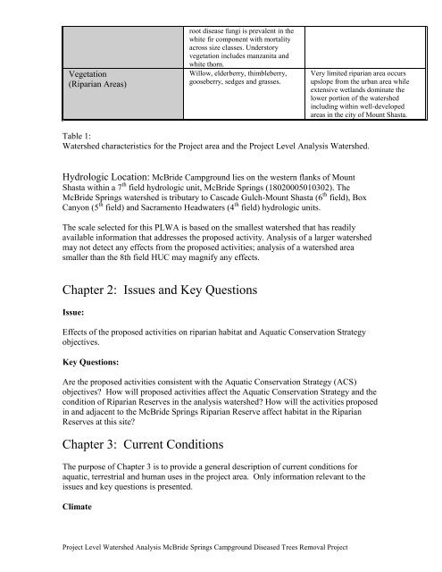
Vegetation<br />
(Riparian Areas)<br />
root disease fungi is prevalent in the<br />
white fir component with mortality<br />
across size classes. Understory<br />
vegetation includes manzanita and<br />
white thorn.<br />
Willow, elderberry, thimbleberry,<br />
gooseberry, sedges and grasses.<br />
<strong>Project</strong> <strong>Level</strong> <strong>Watershed</strong> <strong>Analysis</strong> <strong>McBride</strong> <strong>Springs</strong> <strong>Campground</strong> Diseased Trees Removal <strong>Project</strong><br />
Very limited riparian area occurs<br />
upslope from the urban area while<br />
extensive wetlands dominate the<br />
lower portion of the watershed<br />
including within well-developed<br />
areas in the city of Mount Shasta.<br />
Table 1:<br />
<strong>Watershed</strong> characteristics for the <strong>Project</strong> area and the <strong>Project</strong> <strong>Level</strong> <strong>Analysis</strong> <strong>Watershed</strong>.<br />
Hydrologic Location: <strong>McBride</strong> <strong>Campground</strong> lies on the western flanks of Mount<br />
Shasta within a 7 th field hydrologic unit, <strong>McBride</strong> <strong>Springs</strong> (18020005010302). The<br />
<strong>McBride</strong> <strong>Springs</strong> watershed is tributary to Cascade Gulch-Mount Shasta (6 th field), Box<br />
Canyon (5 th field) and Sacramento Headwaters (4 th field) hydrologic units.<br />
The scale selected for this PLWA is based on the smallest watershed that has readily<br />
available information that addresses the proposed activity. <strong>Analysis</strong> of a larger watershed<br />
may not detect any effects from the proposed activities; analysis of a watershed area<br />
smaller than the 8th field HUC may magnify any effects.<br />
Chapter 2: Issues and Key Questions<br />
Issue:<br />
Effects of the proposed activities on riparian habitat and Aquatic Conservation Strategy<br />
objectives.<br />
Key Questions:<br />
Are the proposed activities consistent with the Aquatic Conservation Strategy (ACS)<br />
objectives? How will proposed activities affect the Aquatic Conservation Strategy and the<br />
condition of Riparian Reserves in the analysis watershed? How will the activities proposed<br />
in and adjacent to the <strong>McBride</strong> <strong>Springs</strong> Riparian Reserve affect habitat in the Riparian<br />
Reserves at this site?<br />
Chapter 3: Current Conditions<br />
The purpose of Chapter 3 is to provide a general description of current conditions for<br />
aquatic, terrestrial and human uses in the project area. Only information relevant to the<br />
issues and key questions is presented.<br />
Climate


