Lost Christchurch - Christchurch City Libraries
Lost Christchurch - Christchurch City Libraries
Lost Christchurch - Christchurch City Libraries

You also want an ePaper? Increase the reach of your titles
YUMPU automatically turns print PDFs into web optimized ePapers that Google loves.
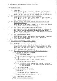
<strong>Lost</strong> <strong>Christchurch</strong><br />
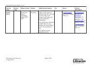
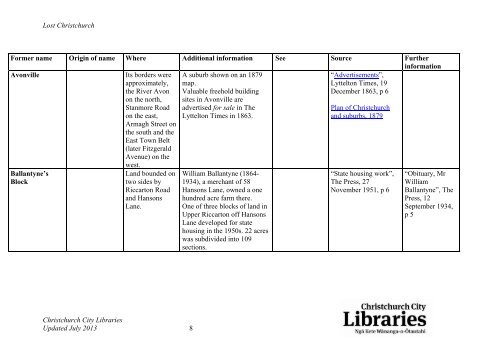
Former name Origin of name Where Additional information See Source Further<br />
information<br />
Avonville Its borders were A suburb shown on an 1879<br />
“Advertisements”,<br />
approximately, map.<br />
Lyttelton Times, 19<br />
the River Avon Valuable freehold building<br />
December 1863, p 6<br />
on the north, sites in Avonville are<br />
Stanmore Road advertised for sale in The<br />
Plan of <strong>Christchurch</strong><br />
on the east,<br />
Armagh Street on<br />
the south and the<br />
East Town Belt<br />
(later Fitzgerald<br />
Avenue) on the<br />
west.<br />
Lyttelton Times in 1863.<br />
and suburbs, 1879<br />
Ballantyne’s<br />
Land bounded on William Ballantyne (1864-<br />
“State housing work”, “Obituary, Mr<br />
Block<br />
two sides by 1934), a merchant of 58<br />
The Press, 27 William<br />
Riccarton Road Hansons Lane, owned a one<br />
November 1951, p 6 Ballantyne”, The<br />
and Hansons hundred acre farm there.<br />
Press, 12<br />
Lane.<br />
One of three blocks of land in<br />
September 1934,<br />
Upper Riccarton off Hansons<br />
Lane developed for state<br />
housing in the 1950s. 22 acres<br />
was subdivided into 109<br />
sections.<br />
p 5<br />
<strong>Christchurch</strong> <strong>City</strong> <strong>Libraries</strong><br />
Updated July 2013 8