Skykomish River, Washington Impact of Ongoing Glacier Retreat on ...
Skykomish River, Washington Impact of Ongoing Glacier Retreat on ...
Skykomish River, Washington Impact of Ongoing Glacier Retreat on ...

You also want an ePaper? Increase the reach of your titles
YUMPU automatically turns print PDFs into web optimized ePapers that Google loves.
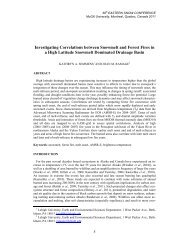
67 th EASTERN SNOW CONFERENCE<br />
Jiminy Peak Mountain Resort, Hancock, MA, USA 2010<br />
<str<strong>on</strong>g>Skykomish</str<strong>on</strong>g> <str<strong>on</strong>g>River</str<strong>on</strong>g>, <str<strong>on</strong>g>Washingt<strong>on</strong></str<strong>on</strong>g> <str<strong>on</strong>g>Impact</str<strong>on</strong>g> <str<strong>on</strong>g>of</str<strong>on</strong>g> <str<strong>on</strong>g>Ongoing</str<strong>on</strong>g> <str<strong>on</strong>g>Glacier</str<strong>on</strong>g> <str<strong>on</strong>g>Retreat</str<strong>on</strong>g><br />
<strong>on</strong> Streamflow<br />
ABSTRACT:<br />
M.S. PELTO 1<br />
<str<strong>on</strong>g>Glacier</str<strong>on</strong>g> retreat and changes in summer run<str<strong>on</strong>g>of</str<strong>on</strong>g>f have been quite pr<strong>on</strong>ounced in the <str<strong>on</strong>g>Skykomish</str<strong>on</strong>g><br />
<str<strong>on</strong>g>River</str<strong>on</strong>g> Basin, North Cascades, <str<strong>on</strong>g>Washingt<strong>on</strong></str<strong>on</strong>g>. In the <str<strong>on</strong>g>Skykomish</str<strong>on</strong>g> <str<strong>on</strong>g>River</str<strong>on</strong>g> watershed from 1958-2009<br />
glacier area has declined from 3.8 km 2 to 2.1 km 2 . Columbia, Foss, Hinman and Lynch <str<strong>on</strong>g>Glacier</str<strong>on</strong>g><br />
the primary glaciers in the basin declined in area by 10%, 60%, 90% and 35% respectively since<br />
1958. Annual mass balance measurements have been completed from 1984-2009 <strong>on</strong> Columbia,<br />
Foss and Lynch <str<strong>on</strong>g>Glacier</str<strong>on</strong>g>. They have lost -13.3 m, -14.2 m and -11.7 m respectively, an average <str<strong>on</strong>g>of</str<strong>on</strong>g><br />
14 m <str<strong>on</strong>g>of</str<strong>on</strong>g> ice thickness. The glacier retreat has and is exposing new alpine lakes. Despite 15%<br />
higher ablati<strong>on</strong> rates, the 46% reducti<strong>on</strong> in glacier area has led to a 40% reducti<strong>on</strong> glacier run<str<strong>on</strong>g>of</str<strong>on</strong>g>f<br />
between 1958 and 2009, 50,000 m 3 /day. Examinati<strong>on</strong> <str<strong>on</strong>g>of</str<strong>on</strong>g> USGS streamflow records indicate that<br />
<str<strong>on</strong>g>Skykomish</str<strong>on</strong>g> <str<strong>on</strong>g>River</str<strong>on</strong>g> summer streamflow (July-September) from 1950-2006 has declined 35% in the<br />
watershed, spring run<str<strong>on</strong>g>of</str<strong>on</strong>g>f (April-June) has declined 15%, while winter run<str<strong>on</strong>g>of</str<strong>on</strong>g>f (November-March)<br />
has increased 11 % due to increasing winter rain and melt events reducing snowpack storage<br />
efficiency. The 40% reducti<strong>on</strong> in glacier run<str<strong>on</strong>g>of</str<strong>on</strong>g>f has not led to a significant decline in the<br />
percentage <str<strong>on</strong>g>of</str<strong>on</strong>g> summer run<str<strong>on</strong>g>of</str<strong>on</strong>g>f c<strong>on</strong>tributi<strong>on</strong>, given the 35% decline in total summer streamflow.<br />
The impact <strong>on</strong> river discharge <str<strong>on</strong>g>of</str<strong>on</strong>g> glacier run<str<strong>on</strong>g>of</str<strong>on</strong>g>f decline is limited as the percentage <str<strong>on</strong>g>of</str<strong>on</strong>g> total<br />
streamflow, since glacier run<str<strong>on</strong>g>of</str<strong>on</strong>g>f peaks at close to 3-5% in August. The loss <str<strong>on</strong>g>of</str<strong>on</strong>g> glacier area will<br />
c<strong>on</strong>tinue to lead to reduced glacier run<str<strong>on</strong>g>of</str<strong>on</strong>g>f and late summer streamflow, with limited impact <strong>on</strong> the<br />
flow <str<strong>on</strong>g>of</str<strong>on</strong>g> the main stem <str<strong>on</strong>g>of</str<strong>on</strong>g> the <str<strong>on</strong>g>Skykomish</str<strong>on</strong>g> <str<strong>on</strong>g>River</str<strong>on</strong>g> except during periods <str<strong>on</strong>g>of</str<strong>on</strong>g> critically low flow when<br />
glaciers currently c<strong>on</strong>tribute 10% <str<strong>on</strong>g>of</str<strong>on</strong>g> the streamflow.<br />
Keywords: glacier run<str<strong>on</strong>g>of</str<strong>on</strong>g>f, glacier retreat, snowpack, stream discharge, North Cascades<br />
INTRODUCTION<br />
<str<strong>on</strong>g>Glacier</str<strong>on</strong>g>s act as natural reservoirs storing water in a frozen state instead <str<strong>on</strong>g>of</str<strong>on</strong>g> behind a dam.<br />
<str<strong>on</strong>g>Glacier</str<strong>on</strong>g>s modify streamflow releasing the most run<str<strong>on</strong>g>of</str<strong>on</strong>g>f during the warmest, driest periods, summer,<br />
when all other sources <str<strong>on</strong>g>of</str<strong>on</strong>g> water are at a minimum (Fountain and Tangborn, 1985). Annual glacier<br />
run<str<strong>on</strong>g>of</str<strong>on</strong>g>f is highest in warm, dry summers and lowest during wet, cool summers (Rasmussen and<br />
Tangborn, 1976). The amount <str<strong>on</strong>g>of</str<strong>on</strong>g> glacier run<str<strong>on</strong>g>of</str<strong>on</strong>g>f is the product <str<strong>on</strong>g>of</str<strong>on</strong>g> surface area and ablati<strong>on</strong> rate<br />
(Pelto, 2008). The North Cascade <str<strong>on</strong>g>Glacier</str<strong>on</strong>g> Climate Project began an annual m<strong>on</strong>itoring program<br />
<str<strong>on</strong>g>of</str<strong>on</strong>g> North Cascade glaciers in 1984 (Pelto, 1996). Mass balance is observed annually <strong>on</strong> ten<br />
glaciers. The cumulative mass balance loss has been 20-30% <str<strong>on</strong>g>of</str<strong>on</strong>g> the entire glacier volume in 25<br />
years (Pelto, 2010). All 47 observed glaciers have retreated significantly since 1984, five have<br />
disappeared (Pelto, 2010). North Cascade glaciers provided 800 milli<strong>on</strong> m 3 <str<strong>on</strong>g>of</str<strong>on</strong>g> run<str<strong>on</strong>g>of</str<strong>on</strong>g>f each<br />
summer in the past, but today this c<strong>on</strong>tributi<strong>on</strong> is declining as glacier area available for melting<br />
1 Nichols College, Dudley, MA 01571<br />
23
declines (Bach, 2002; Pelto, 2008). The glacier retreat and loss <str<strong>on</strong>g>of</str<strong>on</strong>g> glacier run<str<strong>on</strong>g>of</str<strong>on</strong>g>f has been quite<br />
pr<strong>on</strong>ounced in the <str<strong>on</strong>g>Skykomish</str<strong>on</strong>g> <str<strong>on</strong>g>River</str<strong>on</strong>g> Basin.<br />
SKYKOMISH WATERSHED HYDROGRAPH<br />
The <str<strong>on</strong>g>Skykomish</str<strong>on</strong>g> <str<strong>on</strong>g>River</str<strong>on</strong>g> watershed drains the west slope <str<strong>on</strong>g>of</str<strong>on</strong>g> the North Cascades (Figure 1). The<br />
USGS <str<strong>on</strong>g>Skykomish</str<strong>on</strong>g> <str<strong>on</strong>g>River</str<strong>on</strong>g> gaging stati<strong>on</strong> at Gold Bar is used in this study. The basin has an area <str<strong>on</strong>g>of</str<strong>on</strong>g><br />
1386 km 2 , the average elevati<strong>on</strong> <str<strong>on</strong>g>of</str<strong>on</strong>g> the basin is 1050 m. This stati<strong>on</strong> is just downstream <str<strong>on</strong>g>of</str<strong>on</strong>g> the<br />
c<strong>on</strong>fluence <str<strong>on</strong>g>of</str<strong>on</strong>g> the North Fork and South Fork <str<strong>on</strong>g>of</str<strong>on</strong>g> the <str<strong>on</strong>g>Skykomish</str<strong>on</strong>g> <str<strong>on</strong>g>River</str<strong>on</strong>g>. The watershed has subwatersheds<br />
that are dominantly pluvial, nival and glacial. The pluvial segments have peak flows<br />
in the winter due to the winter storm events (Dery et al., 2009). Nival streams peak in the May<br />
and June with the high snowmelt and glacial flows peak in July and August during peak snowmelt<br />
(Fountain and Tangborn, 1985; Dery et al., 2009). The <str<strong>on</strong>g>Skykomish</str<strong>on</strong>g> <str<strong>on</strong>g>River</str<strong>on</strong>g> as a whole is a hybrid<br />
basin with the various segments reaching a maximum at different times, and reducing the length<br />
and durati<strong>on</strong> <str<strong>on</strong>g>of</str<strong>on</strong>g> the summer minimum flow period. The period from October-March is a storage<br />
period with precipitati<strong>on</strong> exceeding discharge and from April-August is a period <str<strong>on</strong>g>of</str<strong>on</strong>g> excess run<str<strong>on</strong>g>of</str<strong>on</strong>g>f<br />
release (Figure 2).<br />
Figure 1. The <str<strong>on</strong>g>Skykomish</str<strong>on</strong>g> <str<strong>on</strong>g>River</str<strong>on</strong>g> basin indicating gaging stati<strong>on</strong>s and glaciers.<br />
Alpine run<str<strong>on</strong>g>of</str<strong>on</strong>g>f throughout the mountain range from 1950-2006 has increased in the winter<br />
(November-March), 11% in <str<strong>on</strong>g>Skykomish</str<strong>on</strong>g> Basin (Figure 3) as more frequent rain <strong>on</strong> snow events<br />
enhance melting and reduce snow storage (Mote 2003; Pelto, 2008). The tendency for greater<br />
winter flows and greater maximum flows in the winter is c<strong>on</strong>sistent with the trends in British<br />
Columbia and in the Pacific Northwest (Zhang et al., 2001; Stahl and Moore, 2006; Mote et al.,<br />
2008). The earlier release <str<strong>on</strong>g>of</str<strong>on</strong>g> meltwater in the North Cascades due to warmer spring c<strong>on</strong>diti<strong>on</strong>s and<br />
reduced winter snowpack has become more pr<strong>on</strong>ounced since 1990 when first documented by<br />
Pelto (1993). Total spring run<str<strong>on</strong>g>of</str<strong>on</strong>g>f (April-June) has declined 15% in <str<strong>on</strong>g>Skykomish</str<strong>on</strong>g> Basin, while many<br />
North Cascades basins have not seen a significant spring change (pelto, 2008). The lower mean<br />
altitude <str<strong>on</strong>g>of</str<strong>on</strong>g> the basin versus others examined by Pelto (2008) emphasizes the earlier snowpack<br />
24
melting leading to greater c<strong>on</strong>tributi<strong>on</strong>s to run<str<strong>on</strong>g>of</str<strong>on</strong>g>f from snow melt during the winter. Summer<br />
run<str<strong>on</strong>g>of</str<strong>on</strong>g>f has decreased markedly in all six North Cascade basins examined (Pelto, 2008) and in<br />
neighboring BC (Stahl and Moore, 2006). The 35% decline in <str<strong>on</strong>g>Skykomish</str<strong>on</strong>g> <str<strong>on</strong>g>River</str<strong>on</strong>g> is the largest<br />
(Figure 3).<br />
Figure 2. Annual precipitati<strong>on</strong> and hydrograph for the <str<strong>on</strong>g>Skykomish</str<strong>on</strong>g> <str<strong>on</strong>g>River</str<strong>on</strong>g> basin. Run<str<strong>on</strong>g>of</str<strong>on</strong>g>f is at the<br />
USGS gaging stati<strong>on</strong> <strong>on</strong> the river at Gold Bar. Precipitati<strong>on</strong> data is from Stevens Pass 1210 m at<br />
the headwaters <str<strong>on</strong>g>of</str<strong>on</strong>g> the basin.<br />
Figure 3. Trends in mean seas<strong>on</strong>al run<str<strong>on</strong>g>of</str<strong>on</strong>g>f in the Skymoish <str<strong>on</strong>g>River</str<strong>on</strong>g> basin 1950-2006. Streamflow at the USGS<br />
gaging stati<strong>on</strong> <strong>on</strong> the <str<strong>on</strong>g>Skykomish</str<strong>on</strong>g> <str<strong>on</strong>g>River</str<strong>on</strong>g> at Gold Bar. Most notable is the c<strong>on</strong>sistently lower summer<br />
streamflow since 1976, despite an increase in annual precipitati<strong>on</strong> during this interval.<br />
25
This decline in summer run<str<strong>on</strong>g>of</str<strong>on</strong>g>f is apparent in the change in fracti<strong>on</strong> <str<strong>on</strong>g>of</str<strong>on</strong>g> the total annual run<str<strong>on</strong>g>of</str<strong>on</strong>g>f.<br />
Rasmussen and Tangborn (1976) noted that the basin had just over 40% <str<strong>on</strong>g>of</str<strong>on</strong>g> the area above 1200 m<br />
and had a summer fracti<strong>on</strong> <str<strong>on</strong>g>of</str<strong>on</strong>g> run<str<strong>on</strong>g>of</str<strong>on</strong>g>f <str<strong>on</strong>g>of</str<strong>on</strong>g> 43% May-Sept. for the 1929-1973 period. From 1985-<br />
2006 the summer fracti<strong>on</strong> <str<strong>on</strong>g>of</str<strong>on</strong>g> run<str<strong>on</strong>g>of</str<strong>on</strong>g>f has declined to 36% <str<strong>on</strong>g>of</str<strong>on</strong>g> the total run<str<strong>on</strong>g>of</str<strong>on</strong>g>f. Annual precipitati<strong>on</strong><br />
has risen during this same period in the regi<strong>on</strong> and in the basin (Pelto, 2008; Mote et. al., 2008).<br />
The most likely cause <str<strong>on</strong>g>of</str<strong>on</strong>g> the decline in summer fracti<strong>on</strong>al flow is the reduced snowpack storage<br />
efficiency. Mote (2003) in examining 40 stati<strong>on</strong>s in the <str<strong>on</strong>g>Washingt<strong>on</strong></str<strong>on</strong>g> and British Columbia noted<br />
that substantial declines in SWE coincide with significant increases in temperature, and occur in<br />
spite <str<strong>on</strong>g>of</str<strong>on</strong>g> increases in precipitati<strong>on</strong>. A key ratio that can be used to identify the relati<strong>on</strong>ship between<br />
the snowpack and precipitati<strong>on</strong> is the ratio between winter precipitati<strong>on</strong> (November-March) and<br />
April 1 SWE. An increasing ratio indicates a greater percentage <str<strong>on</strong>g>of</str<strong>on</strong>g> precipitati<strong>on</strong> is falling and<br />
remaining as snow. A declining ratio indicates that greater percentages <str<strong>on</strong>g>of</str<strong>on</strong>g> precipitati<strong>on</strong> occur as<br />
rain instead <str<strong>on</strong>g>of</str<strong>on</strong>g> snow and/or that melt <str<strong>on</strong>g>of</str<strong>on</strong>g> winter snowpack is increasing. Mote et. al., (2008) noted<br />
that the fracti<strong>on</strong> <str<strong>on</strong>g>of</str<strong>on</strong>g> the precipitati<strong>on</strong> from November-March retained as snow <strong>on</strong> April 1 had<br />
declined by 28% overall in the Cascades <str<strong>on</strong>g>of</str<strong>on</strong>g> <str<strong>on</strong>g>Washingt<strong>on</strong></str<strong>on</strong>g>, and 19 and 20% respectively at the two<br />
stati<strong>on</strong>s closest to the <str<strong>on</strong>g>Skykomish</str<strong>on</strong>g> <str<strong>on</strong>g>River</str<strong>on</strong>g>. Pelto (2008) examining snowpack at Stevens Pass in the<br />
<str<strong>on</strong>g>Skykomish</str<strong>on</strong>g> <str<strong>on</strong>g>River</str<strong>on</strong>g> basin noted a decline in snowpack storage efficiency <str<strong>on</strong>g>of</str<strong>on</strong>g> 30%.<br />
GLACIER CHANGE<br />
In the <str<strong>on</strong>g>Skykomish</str<strong>on</strong>g> <str<strong>on</strong>g>River</str<strong>on</strong>g> watershed from 1958-2009 glacier area has declined from 3.8 km 2 to<br />
2.1 km 2 . There are four principal glaciers in the basin comprising 90% <str<strong>on</strong>g>of</str<strong>on</strong>g> the glaciated area<br />
Columbia, Foss, Hinman and Lynch <str<strong>on</strong>g>Glacier</str<strong>on</strong>g>. Annual mass balance measurements have been<br />
completed from 1984-2009 <strong>on</strong> Columbia, Foss and Lynch <str<strong>on</strong>g>Glacier</str<strong>on</strong>g>. They have lost -13.3 meters, -<br />
14.2 meters and -11.7 meters respectively, this is an average <str<strong>on</strong>g>of</str<strong>on</strong>g> 14 meters <str<strong>on</strong>g>of</str<strong>on</strong>g> ice thickness (Figurre<br />
4). Ablati<strong>on</strong> measurements are completed <strong>on</strong> each glacier, each summer, and changes in glacier<br />
area are assessed at least every three years. During the course <str<strong>on</strong>g>of</str<strong>on</strong>g> the mass balance measurements<br />
the glacier boundaries have also been mapped. Their area has declined 10%, 60%, 90% and 35%<br />
respectively since the 1958 USGS mapping. An examinati<strong>on</strong> <str<strong>on</strong>g>of</str<strong>on</strong>g> the USGS images <str<strong>on</strong>g>of</str<strong>on</strong>g> the glaciers<br />
from 1958, 1960 and 1964 indicate that the glacier boundaries were accurate in 1958. The glacier<br />
retreat has and is exposing new alpine lakes.<br />
Figure 4. Annual mass balance <str<strong>on</strong>g>of</str<strong>on</strong>g> <str<strong>on</strong>g>Skykomish</str<strong>on</strong>g> <str<strong>on</strong>g>River</str<strong>on</strong>g> basin glaciers 1984-2009.<br />
Lynch <str<strong>on</strong>g>Glacier</str<strong>on</strong>g> is <strong>on</strong> the north side <str<strong>on</strong>g>of</str<strong>on</strong>g> Mount Daniels, the highest point in the <str<strong>on</strong>g>Skykomish</str<strong>on</strong>g><br />
Watershed and drains into the South Fork <str<strong>on</strong>g>Skykomish</str<strong>on</strong>g> <str<strong>on</strong>g>River</str<strong>on</strong>g>. In USGS maps <str<strong>on</strong>g>of</str<strong>on</strong>g> the regi<strong>on</strong> the<br />
glacier flows down the mountain ending in basin, with a modest fringe <str<strong>on</strong>g>of</str<strong>on</strong>g> water showing, this<br />
c<strong>on</strong>figurati<strong>on</strong> is evident in the 1960 image below. This lake, usually referred to as Pea Soup Lake,<br />
26
expanded rapidly between 1978 and 1983, as the porti<strong>on</strong> <str<strong>on</strong>g>of</str<strong>on</strong>g> the glacier occupying this basin<br />
disintegrated, by 1988 the lake was fully open water. Lynch <str<strong>on</strong>g>Glacier</str<strong>on</strong>g> retreated 390 m from 1950-<br />
1979, almost all <str<strong>on</strong>g>of</str<strong>on</strong>g> it occurring in a rapid breakup <str<strong>on</strong>g>of</str<strong>on</strong>g> the glacier in Pea Soup Lake. From 1979-<br />
2009 the glacier has retreated 132 m from the lake shore. Annual mass balance measurements<br />
indicate the loss <str<strong>on</strong>g>of</str<strong>on</strong>g> 13 meters <str<strong>on</strong>g>of</str<strong>on</strong>g> ice thickness <strong>on</strong> average. More importantly in 2003 <strong>on</strong> the<br />
upper west secti<strong>on</strong> <str<strong>on</strong>g>of</str<strong>on</strong>g> the glacier secti<strong>on</strong> a bedrock ridge and scattered outcrops were exposed.<br />
The width <str<strong>on</strong>g>of</str<strong>on</strong>g> the glacier at this elevati<strong>on</strong> has been reduced by 135 m, 15%. The features have<br />
c<strong>on</strong>tinued to expand, indicative <str<strong>on</strong>g>of</str<strong>on</strong>g> thinning <str<strong>on</strong>g>of</str<strong>on</strong>g> the glacier in what was its accumulati<strong>on</strong> z<strong>on</strong>e, note<br />
the rock outcrop <strong>on</strong> the upper right porti<strong>on</strong> <str<strong>on</strong>g>of</str<strong>on</strong>g> the glacier in 2007 in the right image (Figure 5).<br />
This is an indicator <str<strong>on</strong>g>of</str<strong>on</strong>g> a glacier that cannot survive current climate (Pelto, 2010). Lynch <str<strong>on</strong>g>Glacier</str<strong>on</strong>g><br />
has lost 35% <str<strong>on</strong>g>of</str<strong>on</strong>g> its area since 1958.<br />
Figure 5. Lynch <str<strong>on</strong>g>Glacier</str<strong>on</strong>g>, North Cascades in 1960 (Austin Post, USGS) and 2007 (below). There are new<br />
rock outcroppings in the accumulati<strong>on</strong> z<strong>on</strong>e <strong>on</strong> the right side (west side) <str<strong>on</strong>g>of</str<strong>on</strong>g> the glacier, the width <str<strong>on</strong>g>of</str<strong>on</strong>g> exposed<br />
rock <strong>on</strong> the ridge <strong>on</strong> the right side <str<strong>on</strong>g>of</str<strong>on</strong>g> the glacier has expanded (A and B). On the left side <str<strong>on</strong>g>of</str<strong>on</strong>g> the glacier the<br />
snow c<strong>on</strong>necti<strong>on</strong> to the Daniels <str<strong>on</strong>g>Glacier</str<strong>on</strong>g> which existed up through 1987, is now an exposed ridge (C).<br />
27
Hinman <str<strong>on</strong>g>Glacier</str<strong>on</strong>g> is <strong>on</strong> the west side <str<strong>on</strong>g>of</str<strong>on</strong>g> Mount Hinman drains into the South Fork <str<strong>on</strong>g>Skykomish</str<strong>on</strong>g><br />
<str<strong>on</strong>g>River</str<strong>on</strong>g>. This was the largest glacier in the North Cascades south <str<strong>on</strong>g>of</str<strong>on</strong>g> <str<strong>on</strong>g>Glacier</str<strong>on</strong>g> Peak 50 years ago.<br />
Today it is nearly g<strong>on</strong>e. Hinman Lake, un<str<strong>on</strong>g>of</str<strong>on</strong>g>ficial name, has taken the place <str<strong>on</strong>g>of</str<strong>on</strong>g> the lower porti<strong>on</strong> <str<strong>on</strong>g>of</str<strong>on</strong>g><br />
the former glacier, which still has a couple <str<strong>on</strong>g>of</str<strong>on</strong>g> separated relict ice masses. In the USGS map based<br />
<strong>on</strong> 1958 photographs the glacier extends from the top <str<strong>on</strong>g>of</str<strong>on</strong>g> Mount Hinman at 2300 meters to the<br />
bottom <str<strong>on</strong>g>of</str<strong>on</strong>g> the valley at 1525 meters. Hinman <str<strong>on</strong>g>Glacier</str<strong>on</strong>g> from the west in 1988 is now a group <str<strong>on</strong>g>of</str<strong>on</strong>g> four<br />
separated ice masses, three are significant in size still. A 2009 view from the far end, north end <str<strong>on</strong>g>of</str<strong>on</strong>g><br />
Lake Hinman up the valley and mountain side that was covered by the Hinman <str<strong>on</strong>g>Glacier</str<strong>on</strong>g>, now 90%<br />
g<strong>on</strong>e compared to 1958 (Figure 6). The new lake is <strong>on</strong>e kilometer l<strong>on</strong>g. This is no l<strong>on</strong>ger a glacier<br />
and is just a few relict pieces <str<strong>on</strong>g>of</str<strong>on</strong>g> ice as viewed from the 1958 terminus locati<strong>on</strong> in 2009, the largest<br />
relict has an area <str<strong>on</strong>g>of</str<strong>on</strong>g> 0.05 km 2 .<br />
Foss <str<strong>on</strong>g>Glacier</str<strong>on</strong>g> is <strong>on</strong> the Northeast side <str<strong>on</strong>g>of</str<strong>on</strong>g> Mount Hinman and drains into the South Fork<br />
<str<strong>on</strong>g>Skykomish</str<strong>on</strong>g> <str<strong>on</strong>g>River</str<strong>on</strong>g>. As recently as 1984 this glacier covered the majority <str<strong>on</strong>g>of</str<strong>on</strong>g> this mountain face.<br />
Today the glacier is rapidly thinning, separating into smaller parts and retreating. Foss <str<strong>on</strong>g>Glacier</str<strong>on</strong>g> had<br />
by the middle <str<strong>on</strong>g>of</str<strong>on</strong>g> August lost all <str<strong>on</strong>g>of</str<strong>on</strong>g> its snowcover in 1992, 1993, 1994, 1998, 2003, 2005, and<br />
2009. This has led to thinning <str<strong>on</strong>g>of</str<strong>on</strong>g> the upper reaches <str<strong>on</strong>g>of</str<strong>on</strong>g> the glacier. Thinning <str<strong>on</strong>g>of</str<strong>on</strong>g> the upper reaches,<br />
what should be the accumulati<strong>on</strong> z<strong>on</strong>e <str<strong>on</strong>g>of</str<strong>on</strong>g> a glacier is an indicator <str<strong>on</strong>g>of</str<strong>on</strong>g> a glacier that cannot survive<br />
current climate (Pelto, 2010). The lower secti<strong>on</strong> detached from the upper secti<strong>on</strong> in 2003 and<br />
melted away in 2009. Foss <str<strong>on</strong>g>Glacier</str<strong>on</strong>g> in 1988, in the middle in 2005 with the 1988 outline, and in<br />
2009 (Figure 7). In the latter two images the snowpack is essentially g<strong>on</strong>e from this dying glacier.<br />
Annual balance measurements indicate a loss <str<strong>on</strong>g>of</str<strong>on</strong>g> over 15 meters <str<strong>on</strong>g>of</str<strong>on</strong>g> average ice thickness, which for<br />
a glacier that averaged 30-40 m in thickness represents 40-50% <str<strong>on</strong>g>of</str<strong>on</strong>g> the volume <str<strong>on</strong>g>of</str<strong>on</strong>g> the glacier lost<br />
between 1984 and 2009. The reducti<strong>on</strong> in glacier extent has been 40% between 1984 and 2009<br />
and 60% between 1958 and 2009.<br />
Figure 6. Above, Hinman <str<strong>on</strong>g>Glacier</str<strong>on</strong>g> from the west in 1988 is a group <str<strong>on</strong>g>of</str<strong>on</strong>g> four separated ice masses, three are<br />
significant in size still. Two ice masses A and B are indicated. Below, a 2009 view from the far end, north<br />
end <str<strong>on</strong>g>of</str<strong>on</strong>g> Lake Hinman up the valley and mountain side that was covered by the Hinman <str<strong>on</strong>g>Glacier</str<strong>on</strong>g>, now 90%<br />
g<strong>on</strong>e compared to 1958. Photograph taken from near the 1958 terminus positi<strong>on</strong>, arrow indicates terminus.<br />
The lake did not exist in 1958.<br />
Columbia <str<strong>on</strong>g>Glacier</str<strong>on</strong>g> occupies a deep cirque above Blanca Lake ranging in altitude from 1460 m to<br />
1720 m and is the headwaters <str<strong>on</strong>g>of</str<strong>on</strong>g> the North Fork <str<strong>on</strong>g>of</str<strong>on</strong>g> the <str<strong>on</strong>g>Skykomish</str<strong>on</strong>g> <str<strong>on</strong>g>River</str<strong>on</strong>g>. Kyes, M<strong>on</strong>te Cristo and<br />
Columbia Peaks surround the glacier with summits over 2200 m. This glacier has the lowest mean<br />
altitude <str<strong>on</strong>g>of</str<strong>on</strong>g> any substantial glacier in the North Cascades. The glacier is the beneficiary <str<strong>on</strong>g>of</str<strong>on</strong>g> locally<br />
heavy precipitati<strong>on</strong> and orographic lifting over the surrounding peaks causing cooling <str<strong>on</strong>g>of</str<strong>on</strong>g> the air<br />
mass greater than that expected from the elevati<strong>on</strong> <str<strong>on</strong>g>of</str<strong>on</strong>g> the glacier. Facing southeast Columbia<br />
<str<strong>on</strong>g>Glacier</str<strong>on</strong>g> is protected from afterno<strong>on</strong> sun. During the winters storm winds sweep from the west<br />
across M<strong>on</strong>te Cristo Pass dropping snow in the lee <strong>on</strong> Columbia <str<strong>on</strong>g>Glacier</str<strong>on</strong>g>. Avalanches spilling<br />
28
from the mountains above descend <strong>on</strong>to and spread across Columbia <str<strong>on</strong>g>Glacier</str<strong>on</strong>g>. The avalanche fans<br />
created by the settled avalanche snows are 6 m deep even late in the summer. Columbia <str<strong>on</strong>g>Glacier</str<strong>on</strong>g><br />
has retreated 134 m since 1984. The head <str<strong>on</strong>g>of</str<strong>on</strong>g> the glacier has retreated 90 m. The key issue is that<br />
the glacier is thinning as appreciably in the accumulati<strong>on</strong> z<strong>on</strong>e in the upper cirque basin as at the<br />
terminus (Pelto and Hartzell, 2003). This indicates a glacier that is in disequilibrium with current<br />
climate and will melt away with a c<strong>on</strong>tinuati<strong>on</strong> <str<strong>on</strong>g>of</str<strong>on</strong>g> the current climate c<strong>on</strong>diti<strong>on</strong>s. The glacier has<br />
lost 15 m in thickness since 1984, but still remains a thick glacier, over 75 meters in the upper<br />
basin and will not disappear quickly (Pelto, 2010). In 2003, 2004, 2005 and 2009 there has been<br />
nearly a complete exposure <str<strong>on</strong>g>of</str<strong>on</strong>g> the glacier surface and the loss <str<strong>on</strong>g>of</str<strong>on</strong>g> all firn and snowcover <strong>on</strong> the<br />
glacier. This exposed more than 50 annual layers in the 2005 (Figure 8). <str<strong>on</strong>g>Glacier</str<strong>on</strong>g> run<str<strong>on</strong>g>of</str<strong>on</strong>g>f<br />
measured directly below the glacier in combinati<strong>on</strong> with ablati<strong>on</strong> <strong>on</strong> the glacier indicate a range<br />
from 40,000-90,000 m3/day during the summer melt seas<strong>on</strong> from this glacier.<br />
Figure 7. Foss <str<strong>on</strong>g>Glacier</str<strong>on</strong>g>, North Cascades 1988 and 2005 indicating the change in the extent <str<strong>on</strong>g>of</str<strong>on</strong>g> the glacier.<br />
There is substantial marginal retreat in the accumulati<strong>on</strong> z<strong>on</strong>e and new rock outcroppings in the accumulati<strong>on</strong><br />
z<strong>on</strong>e.<br />
29
GLACIER RUNOFF<br />
Annual glacier run<str<strong>on</strong>g>of</str<strong>on</strong>g>f is the product <str<strong>on</strong>g>of</str<strong>on</strong>g> annual ablati<strong>on</strong> and glacier area a 15% increase in<br />
summer mass balance has been observed for the 1959-1983 period versus the 1985-2005 period <strong>on</strong><br />
South Cascade <str<strong>on</strong>g>Glacier</str<strong>on</strong>g> (Bidlake). This summer balance is reported in loss per unit area, not<br />
volume and hence is a useful measure <str<strong>on</strong>g>of</str<strong>on</strong>g> the mean summer ablati<strong>on</strong> <strong>on</strong> a glacier. The correlati<strong>on</strong><br />
coefficient in annual balance for the 1984-2005 period between South Casade <str<strong>on</strong>g>Glacier</str<strong>on</strong>g> and<br />
Columbia, Foss and Lynch <str<strong>on</strong>g>Glacier</str<strong>on</strong>g> respectively (Pelto, 2007). This suggests that the 15% increase<br />
in summer ablati<strong>on</strong> rate is applicable to the <str<strong>on</strong>g>Skykomish</str<strong>on</strong>g> Basin glaciers as well. The 15% increase<br />
in summer ablati<strong>on</strong> is <str<strong>on</strong>g>of</str<strong>on</strong>g>fset by the 46% reducti<strong>on</strong> in glacier area over which the melting occurs<br />
leading to a 38% reducti<strong>on</strong> in glacier run<str<strong>on</strong>g>of</str<strong>on</strong>g>f. August ablati<strong>on</strong> measurements <strong>on</strong> the three glaciers<br />
indicate glacier run<str<strong>on</strong>g>of</str<strong>on</strong>g>f is 75,000 m 3 /day in the basin. This is a 50,000 m 3 /day reducti<strong>on</strong> in August<br />
glacier run<str<strong>on</strong>g>of</str<strong>on</strong>g>f from 1958. At the same time as glacier run<str<strong>on</strong>g>of</str<strong>on</strong>g>f has declined so has overall<br />
streamflow, as a result the percentage <str<strong>on</strong>g>of</str<strong>on</strong>g> streamflow c<strong>on</strong>tributed by glaciers has changed little<br />
from the 1950-1984 period compared to the 1985-2006 period (Figure 9), despite reduced glacier<br />
area. The reducti<strong>on</strong> <str<strong>on</strong>g>of</str<strong>on</strong>g> the glacial melt comp<strong>on</strong>ent augmenting summer low flows is already<br />
resulting in more low-flow days in <str<strong>on</strong>g>Skykomish</str<strong>on</strong>g> <str<strong>on</strong>g>River</str<strong>on</strong>g> basin and other area streams. Instream flow<br />
levels c<strong>on</strong>sidered insufficient to maintain short term survival <str<strong>on</strong>g>of</str<strong>on</strong>g> fish is below 10% <str<strong>on</strong>g>of</str<strong>on</strong>g> the mean<br />
annual flow (Tennant, 1976). In the <str<strong>on</strong>g>Skykomish</str<strong>on</strong>g> <str<strong>on</strong>g>River</str<strong>on</strong>g> from 1950-2006 there have been 412 days<br />
with flow below 10% <str<strong>on</strong>g>of</str<strong>on</strong>g> the mean annual flow, 90%, 372 <str<strong>on</strong>g>of</str<strong>on</strong>g> them since 1985. During several <str<strong>on</strong>g>of</str<strong>on</strong>g><br />
these low flow periods measured glacier melt indicates that glacier c<strong>on</strong>tributi<strong>on</strong>s comprise 8-12%<br />
<str<strong>on</strong>g>of</str<strong>on</strong>g> the flow to the river during these lowest flow periods. The low flow periods typically coincide<br />
with high ablati<strong>on</strong> periods <strong>on</strong> the glaciers. It is during these low flow periods that glacier loss will<br />
particularly affect streamflow. Stahl and Moore (2006) noted that glacier-fed streams in British<br />
Columbia have exhibited a decreasing trend for August streamflow.<br />
Figure 8. Accumulati<strong>on</strong> z<strong>on</strong>e <str<strong>on</strong>g>of</str<strong>on</strong>g> the Columbia <str<strong>on</strong>g>Glacier</str<strong>on</strong>g> from the headwall. Notice the number <str<strong>on</strong>g>of</str<strong>on</strong>g> annual<br />
horiz<strong>on</strong>s exposed <strong>on</strong> August 1, 2005. This is the third c<strong>on</strong>secutive year <str<strong>on</strong>g>of</str<strong>on</strong>g> significant negative annual<br />
balances, and follows 2004 when the AAR dropped below 20.<br />
<str<strong>on</strong>g>Glacier</str<strong>on</strong>g> volume loss can lead to an increase in overall streamflow if the volume is sufficiently<br />
large. In the North Cascades in general the glacier volume loss has c<strong>on</strong>tributed up to 6% <str<strong>on</strong>g>of</str<strong>on</strong>g> the<br />
August–September stream-flow (Granshaw and Fountain, 2006). The observed net glacier volume<br />
loss has been a source <str<strong>on</strong>g>of</str<strong>on</strong>g> run<str<strong>on</strong>g>of</str<strong>on</strong>g>f, this is a porti<strong>on</strong> <str<strong>on</strong>g>of</str<strong>on</strong>g> the observed ablati<strong>on</strong> as well. The -0.50 m/a<br />
30
annual glacier mass balance loss spread over the July-September when glacier volume loss occurs<br />
is 0.15-0.25 m 3 /s <str<strong>on</strong>g>of</str<strong>on</strong>g> discharge in <str<strong>on</strong>g>Skykomish</str<strong>on</strong>g> <str<strong>on</strong>g>River</str<strong>on</strong>g>, which is less than 1% <str<strong>on</strong>g>of</str<strong>on</strong>g> the mean summer<br />
streamflow. <str<strong>on</strong>g>Glacier</str<strong>on</strong>g> volume loss has not been mitigating summer low flow in the basin as it has in<br />
other more heavily glaciated basins.<br />
CONCLUSIONS<br />
The c<strong>on</strong>tinued loss <str<strong>on</strong>g>of</str<strong>on</strong>g> glacier area will lead to an <strong>on</strong>going decline in late summer glacier<br />
run<str<strong>on</strong>g>of</str<strong>on</strong>g>f and streamflow in the <str<strong>on</strong>g>Skykomish</str<strong>on</strong>g> Basin. Compared to the 30% decrease in total summer<br />
run<str<strong>on</strong>g>of</str<strong>on</strong>g>f the 40% reducti<strong>on</strong> in glacier run<str<strong>on</strong>g>of</str<strong>on</strong>g>f resulting in a 1.5-2.0% decline in total streamflow is<br />
small. Only when streamflow is at critically low levels does the glacier run<str<strong>on</strong>g>of</str<strong>on</strong>g>f c<strong>on</strong>tributi<strong>on</strong> rise to<br />
~10%and potential loss there <str<strong>on</strong>g>of</str<strong>on</strong>g> become important. The complete loss <str<strong>on</strong>g>of</str<strong>on</strong>g> glaciers will lead to a<br />
further decrease <str<strong>on</strong>g>of</str<strong>on</strong>g> 2-4% in summer run<str<strong>on</strong>g>of</str<strong>on</strong>g>f in the basin. Hinman <str<strong>on</strong>g>Glacier</str<strong>on</strong>g> and Foss <str<strong>on</strong>g>Glacier</str<strong>on</strong>g><br />
c<strong>on</strong>tinue to lose area rapidly and will cease to exist within 20 years. Columbia <str<strong>on</strong>g>Glacier</str<strong>on</strong>g> and Lynch<br />
<str<strong>on</strong>g>Glacier</str<strong>on</strong>g> do not have a persistent accumulati<strong>on</strong> z<strong>on</strong>e but remain thick and will persist and provide<br />
run<str<strong>on</strong>g>of</str<strong>on</strong>g>f to the basin for some time.<br />
Figure 9. Overall glacier discharge based <strong>on</strong> ablati<strong>on</strong> measurements and the percentage <str<strong>on</strong>g>of</str<strong>on</strong>g> the mean August<br />
run<str<strong>on</strong>g>of</str<strong>on</strong>g>f supplied by glacier run<str<strong>on</strong>g>of</str<strong>on</strong>g>f in the short term 1985-2006 and the l<strong>on</strong>g term 1950-1984 for the<br />
<str<strong>on</strong>g>Skykomish</str<strong>on</strong>g> <str<strong>on</strong>g>River</str<strong>on</strong>g> basin at the Gold bar USGS stati<strong>on</strong>.<br />
REFERENCES<br />
Bach A. 2002. Snowshed c<strong>on</strong>tributi<strong>on</strong>s to the Nooksack <str<strong>on</strong>g>River</str<strong>on</strong>g> watershed, North Cascades Range,<br />
<str<strong>on</strong>g>Washingt<strong>on</strong></str<strong>on</strong>g>. Geogr. Rev. 92(2): 192-213.<br />
Dery S., Stahl K., Moore R.D. Whitfield W., Menounos B. and Burford J.E. 2009. Detecti<strong>on</strong> <str<strong>on</strong>g>of</str<strong>on</strong>g><br />
run<str<strong>on</strong>g>of</str<strong>on</strong>g>f timing changes in pluvial, nival and glacial rivers <str<strong>on</strong>g>of</str<strong>on</strong>g> western Canada. Water Res. Res.,<br />
45: doi:1029/2008WR006975.<br />
Fountain, A and Tangborn, W.V. 1985. 'The effect <str<strong>on</strong>g>of</str<strong>on</strong>g> glaciers <strong>on</strong> streamflow variati<strong>on</strong>s'. Water<br />
Res. Res., 21: 579-586.<br />
31
Gersib R., Grigsby S., Freeland C., Bauerfield K., 1999. Process-Based <str<strong>on</strong>g>River</str<strong>on</strong>g> Basin<br />
Characterizati<strong>on</strong>: A Case Study Snohomish Basin, <str<strong>on</strong>g>Washingt<strong>on</strong></str<strong>on</strong>g>. <str<strong>on</strong>g>Washingt<strong>on</strong></str<strong>on</strong>g> Department <str<strong>on</strong>g>of</str<strong>on</strong>g><br />
Ecology. Olympia, WA.<br />
Granshaw F. and Fountain A. 2006. <str<strong>on</strong>g>Glacier</str<strong>on</strong>g> change (1958–1998) in the North Cascades Nati<strong>on</strong>al<br />
Park Complex,<str<strong>on</strong>g>Washingt<strong>on</strong></str<strong>on</strong>g>, USA. J. Glaciol. 52(177): 251-256.<br />
Mote P.W., 2003: Trends in snow water equivalent in the Pacific Northwest and their climatic<br />
causes. Geophys. Res. Letts., 30: DOI 10.1029/2003GL017258<br />
Mote P. Hamlet A. and Salathe E. 2008. Has spring snowpack decline in the <str<strong>on</strong>g>Washingt<strong>on</strong></str<strong>on</strong>g><br />
Cascades? Hydrol. Earth Syst. Sci. 12: 193-206.<br />
Pelto M.S. 1993. Current Behavior <str<strong>on</strong>g>of</str<strong>on</strong>g> <str<strong>on</strong>g>Glacier</str<strong>on</strong>g>s in the North Cascades and Effect <strong>on</strong> Regi<strong>on</strong>al<br />
Water Supplies. <str<strong>on</strong>g>Washingt<strong>on</strong></str<strong>on</strong>g> Geology, 21(2): 3-10.<br />
Pelto M.S. 1996. Recent changes in glacier and alpine run<str<strong>on</strong>g>of</str<strong>on</strong>g>f in the North Cascades, <str<strong>on</strong>g>Washingt<strong>on</strong></str<strong>on</strong>g>.<br />
Hydrol. Processes, 10: 1173-1180.<br />
Pelto M.S., 2006. The Current Disequilibrium <str<strong>on</strong>g>of</str<strong>on</strong>g> North Cascades glaciers. Hydrol. Processes.<br />
20: 769-779.<br />
Pelto M.S., 2008. <str<strong>on</strong>g>Impact</str<strong>on</strong>g> <str<strong>on</strong>g>of</str<strong>on</strong>g> Climate Change <strong>on</strong> North Cascade Alpine <str<strong>on</strong>g>Glacier</str<strong>on</strong>g>s, and Alpine<br />
Run<str<strong>on</strong>g>of</str<strong>on</strong>g>f. Northwest Science, 82: 65-75.<br />
Pelto M.S., 2010. Forecasting Temperate Alpine <str<strong>on</strong>g>Glacier</str<strong>on</strong>g> Survival from Accumulati<strong>on</strong> Z<strong>on</strong>e<br />
Observati<strong>on</strong>s. The Cyrosphere, 3: 323-350.<br />
Post A., Richards<strong>on</strong> D., Tangborn W.V. and Rosselot F.L.. 1971. Inventory <str<strong>on</strong>g>of</str<strong>on</strong>g> glaciers in The<br />
North Cascades, <str<strong>on</strong>g>Washingt<strong>on</strong></str<strong>on</strong>g>. US Geological Survey Pr<str<strong>on</strong>g>of</str<strong>on</strong>g>. Paper, 705-A.<br />
Rasmussen L.A., and Tangborn W.V. 1976. Hydrology <str<strong>on</strong>g>of</str<strong>on</strong>g> the North Cascade Regi<strong>on</strong>, <str<strong>on</strong>g>Washingt<strong>on</strong></str<strong>on</strong>g><br />
1. Run<str<strong>on</strong>g>of</str<strong>on</strong>g>f, Precipitati<strong>on</strong>, and Storage Characteristics. Wat. Res. Res., 12(2): 187-202.<br />
Stahl, K. and Moore R.D.. 2006. Influence <str<strong>on</strong>g>of</str<strong>on</strong>g> watershed glacier coverage <strong>on</strong> summer streamflow<br />
in British Columbia, Canada. Wat. Res. Res. 42: doi: 10.1029/2006WR005022.<br />
Tennant D.L., 1976, Instream flow regimens for fish, wildlife, recreati<strong>on</strong>, and related<br />
envir<strong>on</strong>mental resources, in Osborne, J., and Allman, C., eds., Instream flow needs, volume 2:<br />
Bethesda, Md., American Fisheries Society, Western Divisi<strong>on</strong>, 359-373.<br />
Zhang X., Harvey D.K., Hogg W.D. and Yuzyk T.D., 2001a. Trends in Canadian streamflow.<br />
Wat.Res.Res., 37(4): 987–998.<br />
32