Investigating Correlations between Snowmelt and Forest Fires in a ...
Investigating Correlations between Snowmelt and Forest Fires in a ...
Investigating Correlations between Snowmelt and Forest Fires in a ...

Create successful ePaper yourself
Turn your PDF publications into a flip-book with our unique Google optimized e-Paper software.
68 th EASTERN SNOW CONFERENCE<br />
McGill University, Montreal, Quebec, Canada 2011<br />
<strong>Investigat<strong>in</strong>g</strong> <strong>Correlations</strong> <strong>between</strong> <strong>Snowmelt</strong> <strong>and</strong> <strong>Forest</strong> <strong>Fires</strong> <strong>in</strong><br />
a High Latitude <strong>Snowmelt</strong> Dom<strong>in</strong>ated Dra<strong>in</strong>age Bas<strong>in</strong><br />
ABSTRACT<br />
KATHRYN A. SEMMENS 1 AND JOAN M. RAMAGE 2<br />
High latitude dra<strong>in</strong>age bas<strong>in</strong>s are experienc<strong>in</strong>g <strong>in</strong>creases <strong>in</strong> temperature higher than the global<br />
average with snowmelt dom<strong>in</strong>ated bas<strong>in</strong>s most sensitive to effects <strong>in</strong> w<strong>in</strong>ter due to snowpack’s<br />
<strong>in</strong>tegration of these changes over the season. This may <strong>in</strong>fluence the tim<strong>in</strong>g of snowmelt onset, the<br />
melt-refreeze period, <strong>and</strong> snowpack accumulation result<strong>in</strong>g <strong>in</strong> changes <strong>in</strong> spr<strong>in</strong>g runoff, associated<br />
flood<strong>in</strong>g, <strong>and</strong> drought conditions later <strong>in</strong> the year, possibly enhanc<strong>in</strong>g forest fire potential. Large<br />
burned areas cleared of vegetation change discharge dynamics <strong>and</strong> may affect snowmelt characteristics<br />
<strong>in</strong> subsequent seasons. <strong>Correlations</strong> are tested by compar<strong>in</strong>g forest fire occurrence with<br />
spr<strong>in</strong>g melt onset, the end of melt-refreeze period (after which snow rapidly depletes) <strong>and</strong> early<br />
snowmelt events. Snow characteristics are derived from brightness temperature (Tb) data from the<br />
Advanced Microwave Scann<strong>in</strong>g Radiometer for EOS (AMSR-E) for 2004−2007. Dates of melt<br />
onset, end of melt-refreeze, <strong>and</strong> melt events are def<strong>in</strong>ed with Tb <strong>and</strong> diurnal amplitude variation<br />
thresholds. Areas <strong>and</strong> <strong>in</strong>tensities of forest fires are from MODIS thermal anomaly data (MOD14)<br />
<strong>and</strong> all data are mapped to an EASE-grid to assess spatial correlations. Analysis of high<br />
(2004−2005) <strong>and</strong> low (2006−2007) fire years <strong>in</strong> the Porcup<strong>in</strong>e sub-bas<strong>in</strong> of the Yukon River <strong>in</strong><br />
northeastern Alaska <strong>and</strong> the Yukon Territory show earlier melt onset <strong>and</strong> end of melt-refreeze <strong>in</strong><br />
years <strong>and</strong> areas of high forest fire occurrence. The burned areas also correlate with later melt onset<br />
<strong>and</strong> later end of melt-refreeze <strong>in</strong> subsequent low fire years.<br />
Keywords: snowmelt, forest fire, melt onset, AMSR-E, brightness temperature<br />
INTRODUCTION<br />
For the past several decades boreal ecosystems <strong>in</strong> Alaska <strong>and</strong> Canada have experienced an <strong>in</strong>crease<br />
<strong>in</strong> temperature (1°C over the last 55 years for <strong>in</strong>terior Alaska (Wendler et al., 2010)), as<br />
well as a doubl<strong>in</strong>g of area burned by wildfires <strong>and</strong> an amplification <strong>in</strong> frequency of large fire years<br />
(Stocks et al., 2002; Gillett et al., 2004; Kasischke <strong>and</strong> Turetsky, 2006; Kasischke et al., 2010).<br />
An <strong>in</strong>crease <strong>in</strong> extreme fire events has also occurred <strong>and</strong> late season burn<strong>in</strong>g has quadrupled<br />
(Kasischke et al., 2010). These trends are expected to cont<strong>in</strong>ue with some estimates of annual<br />
burned area <strong>in</strong>creas<strong>in</strong>g 200-300% <strong>in</strong> the next century with significant implications for carbon storage<br />
<strong>and</strong> losses (Balshi et al., 2009; Turetsky et al., 2011). Such projected changes also affect ecosystem<br />
structure <strong>and</strong> forest composition (Shenoy et al., 2011), permafrost degradation, <strong>and</strong> water<br />
<strong>and</strong> air quality due to the creation of black carbon aerosols that deposit on snow surfaces, enhanc<strong>in</strong>g<br />
melt<strong>in</strong>g <strong>and</strong> reduc<strong>in</strong>g surface albedo (R<strong>and</strong>erson et al., 2006). Wildfires can affect snow accumulation<br />
<strong>and</strong> melt<strong>in</strong>g, alter soil characteristics (especially repellency), <strong>and</strong> result <strong>in</strong> more over-<br />
1<br />
Lehigh University, Earth <strong>and</strong> Environmental Sciences Department, 1 West Packer Ave., Bethlehem,<br />
PA 18015, kas409@lehigh.edu<br />
2<br />
Lehigh University, Earth <strong>and</strong> Environmental Sciences Department, 1 West Packer Ave., Bethlehem,<br />
PA 18015, ramage@lehigh.edu<br />
5
l<strong>and</strong> flow, soil distribution <strong>and</strong> <strong>in</strong>creased discharge (Shakesby <strong>and</strong> Doerr, 2006). Additionally, <strong>in</strong><br />
black spruce forests of <strong>in</strong>terior Alaska, fire removal of overstory canopy leads to <strong>in</strong>creased snow<br />
exposure <strong>and</strong> changes <strong>in</strong> surface energy budgets that persist for years after the fire (R<strong>and</strong>erson et<br />
al., 2006).<br />
Annual forest fire occurrence <strong>and</strong> burned area for Alaska have been recorded s<strong>in</strong>ce the 1950s.<br />
These data suggest there is high variability <strong>in</strong> area burned, fluctuat<strong>in</strong>g from high fire years (average<br />
of 66 fires greater than 400 ha) to low fire years (average of 17 fires per year greater than 400<br />
ha) with most fires occurr<strong>in</strong>g <strong>in</strong> the <strong>in</strong>terior of the state, at elevations less than 1000 m a.s.l, <strong>and</strong><br />
dur<strong>in</strong>g the six weeks <strong>between</strong> June <strong>and</strong> mid-July (Kasischke et al., 2002). There is generally a fire<br />
season start<strong>in</strong>g <strong>in</strong> mid June that is driven by thunderstorms <strong>and</strong> convective activity <strong>and</strong> a late<br />
spr<strong>in</strong>g fire season after snowmelt when there is a plethora of dry vegetative fuel <strong>and</strong> low precipitation<br />
(Kasischke et al., 2006). Most fires orig<strong>in</strong>ate as lightn<strong>in</strong>g strikes. Fire cycle, def<strong>in</strong>ed as the<br />
number of years needed to burn the area of <strong>in</strong>terest, <strong>in</strong>creases with elevation due to forest production<br />
decreas<strong>in</strong>g with elevation (Kasischke et al., 2002). Short fire cycles of less than 120 years are<br />
noted <strong>in</strong> the Yukon/Old Crow Bas<strong>in</strong> ecoregion, the area of <strong>in</strong>terest to this study, which is also<br />
characterized by relatively lower average annual precipitation (19.1 cm), relatively higher average<br />
lightn<strong>in</strong>g strikes (4.9 per 10 ×10 km 2 per year), <strong>and</strong> 90% tree cover (Kasischke et al., 2002).<br />
The Yukon/Old Crow Bas<strong>in</strong> ecoregion is part of the Porcup<strong>in</strong>e River sub-bas<strong>in</strong> (Figure 1), the<br />
northeastern 61,400 km 2 portion of the Yukon River bas<strong>in</strong> which dra<strong>in</strong>s 853,300 km 2 cross<strong>in</strong>g<br />
from northwestern Canada through central Alaska. The sub-bas<strong>in</strong> is characterized by a subarctic<br />
nival regime with snowmelt driv<strong>in</strong>g runoff that is generally highest from May to September with<br />
very low w<strong>in</strong>ter flows (Brabets et al., 2000). The bas<strong>in</strong> has relatively low relief, is underla<strong>in</strong> by<br />
cont<strong>in</strong>uous permafrost <strong>and</strong> predom<strong>in</strong>ately covered with needleleaf forest (Brabets <strong>and</strong> Long,<br />
2002). <strong>Forest</strong> fires have a significant impact <strong>in</strong> permafrost areas, caus<strong>in</strong>g long term near-surface<br />
permafrost degradation, active layer deepen<strong>in</strong>g, <strong>and</strong> slow forest regeneration (Burn, 1998). The<br />
dom<strong>in</strong>ant forest l<strong>and</strong> cover, snowmelt driven runoff, <strong>and</strong> the projected future <strong>in</strong>crease <strong>in</strong> burned<br />
area are the primary reasons for study<strong>in</strong>g fire <strong>and</strong> snow dynamics <strong>in</strong> this bas<strong>in</strong>. Additionally, the<br />
Yukon/Old Crow Bas<strong>in</strong> has experienced a decrease <strong>in</strong> fire return <strong>in</strong>terval from 107 (1950−1999)<br />
to 92 (1950−2009) reflect<strong>in</strong>g the <strong>in</strong>crease <strong>in</strong> fire frequency <strong>and</strong> area burned (Kasischke et al.,<br />
2010).<br />
Many studies have <strong>in</strong>vestigated the causes, characteristics <strong>and</strong> effects of fires on the ecology <strong>and</strong><br />
soil <strong>in</strong> the boreal forest. Here, remote sens<strong>in</strong>g data is utilized to <strong>in</strong>vestigate snowmelt <strong>and</strong> how its<br />
tim<strong>in</strong>g correlates to years of high <strong>and</strong> low fires due to similar climatic effects on both snowmelt<br />
<strong>and</strong> forest fire potential. Earlier snowmelt may be <strong>in</strong>dicative of warmer w<strong>in</strong>ter temperatures, <strong>and</strong><br />
an earlier end to the melt-refreeze period may lead to drought conditions <strong>in</strong> the summer due to<br />
depletion of a primary source of moisture. Furthermore, snow behaves differently <strong>in</strong> open <strong>and</strong><br />
forested environments with accumulation under dense canopies be<strong>in</strong>g relatively smaller due to<br />
snow <strong>in</strong>terception <strong>and</strong> sublimation (Pomeroy et al., 2002), so it st<strong>and</strong>s to reason that melt characteristics<br />
vary <strong>in</strong> burned areas, a hybrid of open <strong>and</strong> forested environments. We hypothesize that<br />
snowmelt onset <strong>and</strong> duration will vary significantly before <strong>and</strong> after fire seasons <strong>in</strong> burn areas <strong>and</strong><br />
test this hypothesis by compar<strong>in</strong>g snowmelt tim<strong>in</strong>g parameters for burned versus non-burned areas<br />
as well as compar<strong>in</strong>g high versus low fire years. Related is our secondary hypothesis that snowmelt<br />
runoff will vary <strong>between</strong> fire years with earlier <strong>and</strong> higher peak discharges after high fire<br />
years due to <strong>in</strong>creased overl<strong>and</strong> flow. This research will address whether there tends to be earlier<br />
melt onset <strong>and</strong> end of melt-refreeze period for locations that experience significant forest fires,<br />
suggest<strong>in</strong>g potential utility for fire season forecast<strong>in</strong>g as well as model<strong>in</strong>g of snowmelt runoff.<br />
6
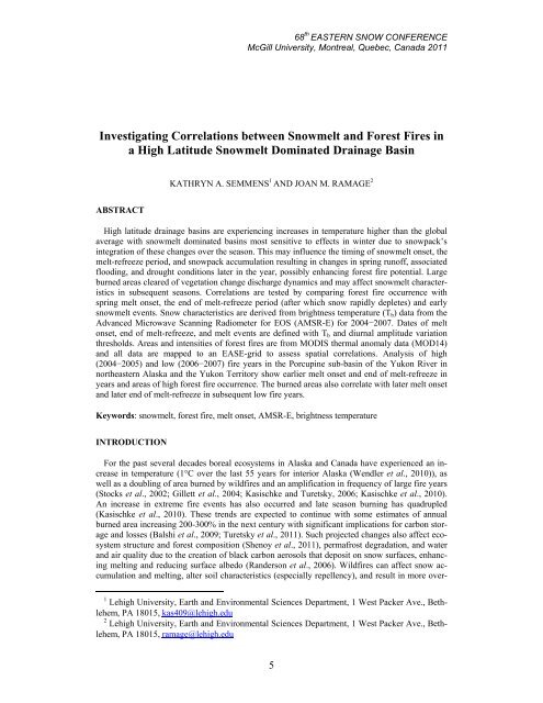
Figure 1. Digital Elevation Model of the Porcup<strong>in</strong>e River Bas<strong>in</strong>. Black circle with symbol Q is the gauge<br />
Porcup<strong>in</strong>e at International Border (67°25’27”N, 140°53’28”W), gross dra<strong>in</strong>age area of 59,800 km 2 ) used <strong>in</strong><br />
the hydrometric analysis. P<strong>in</strong>k squares are pixels referenced <strong>in</strong> results section. Elevation is <strong>in</strong> meters.<br />
DATA AND METHODS<br />
To <strong>in</strong>vestigate correlations <strong>between</strong> forest fire occurrence <strong>and</strong> melt tim<strong>in</strong>g characteristics, melt<br />
onset date, end of melt-refreeze date, <strong>and</strong> the number of early snowmelt events for both burned<br />
<strong>and</strong> non-burned areas are compared both with<strong>in</strong> <strong>and</strong> <strong>between</strong> years from 2004 to 2007. A variety<br />
of data sources <strong>and</strong> techniques are utilized (Table 1).<br />
Table 1 List of data used, their frequency, time series, resolution, <strong>and</strong> source<br />
Data<br />
Frequency/ Date Spatial Res- Data<br />
Wavelength<br />
olution Sources<br />
AMSR-E L2A Brightness Temperature 36.5 GHz (Vpol) 2004−2007 12.5 km NSIDC<br />
MODIS MCD14ML Collection 5<br />
(MOD14 Terra/ MYD14 Aqua Active<br />
Fire)<br />
Hydrometric data Porcup<strong>in</strong>e River @<br />
1.9 <strong>and</strong> 11 µm<br />
(b<strong>and</strong> 21 <strong>and</strong> 31)<br />
2004−2007 1 km<br />
NASA<br />
USDA-<br />
RSAC<br />
Int’l Boundary (67°25’27”N,<br />
140°53’28”W, 59,800 km 2 dra<strong>in</strong>age<br />
area)<br />
- 1987−2009 -<br />
Env.<br />
Canada<br />
Meteorological data Old Crow Airport<br />
(67°34’12”N, 139°50’24”W, 251.2 m<br />
elevation)<br />
- 2004−2007 -<br />
Env.<br />
Canada<br />
7
Snow melt tim<strong>in</strong>g is derived from brightness temperature (Tb) data from the Advanced Microwave<br />
Scann<strong>in</strong>g Radiometer-Earth Observ<strong>in</strong>g System (AMSR-E) on the NASA Earth Observ<strong>in</strong>g<br />
System Aqua satellite (Ashcroft <strong>and</strong> Wentz, 2006). Fire date, extent, <strong>and</strong> radiative power (measured<br />
<strong>in</strong> megawatts, MW) are from Moderate Resolution Imag<strong>in</strong>g Spectroradiometer (MODIS)<br />
thermal anomaly data (MOD14 Active Fire Product) (USDA, 2010). The fire detection po<strong>in</strong>ts are<br />
accurate to ±50 m <strong>and</strong> represent the centroid of a 1 km cell where the fire occurred. Air temperature,<br />
snow, <strong>and</strong> precipitation totals from Old Crow Airport <strong>in</strong> the middle part of the bas<strong>in</strong> are used<br />
for validation <strong>and</strong> hydrometric data from the Porcup<strong>in</strong>e River gauge at the International Boundary<br />
are used to assess trends <strong>in</strong> discharge.<br />
Melt<strong>in</strong>g snow is detectable by AMSR-E brightness temperature (Tb) because the presence of<br />
liquid water with<strong>in</strong> a snowpack <strong>in</strong>creases its emissivity, thus <strong>in</strong>creas<strong>in</strong>g Tb which is a function of<br />
the surface temperature (Ts) <strong>and</strong> emissivity (E) of the material (Tb =ETs). Therefore there is a significant<br />
difference <strong>in</strong> Tb <strong>between</strong> wet (emits close to that of a blackbody) <strong>and</strong> dry snow (Chang et<br />
al., 1975; Ulaby et al., 1986). The 36.5 GHz vertically polarized wavelength is used due to its high<br />
sensitivity to water <strong>in</strong> the snowpack (Ramage et al., 2006). AMSR-E has a 14 × 8 km 2 resolution<br />
at 36.5 GHz frequency <strong>and</strong> has overpass times of 3:30 <strong>and</strong> 13:30 PST, thus improv<strong>in</strong>g on the previously<br />
used SSM/I with a higher spatial resolution. SSM/I data <strong>and</strong> the technique for detect<strong>in</strong>g<br />
snowmelt tim<strong>in</strong>g has been previously established <strong>in</strong> the upper Yukon River bas<strong>in</strong> us<strong>in</strong>g 37GHz<br />
vertically polarized (Ramage et al., 2006) <strong>and</strong> has been found to correlate well with AMSR-E derived<br />
snowmelt onset (Apgar et al., 2007).<br />
AMSR-E generally has more than two observations per day <strong>in</strong> arctic <strong>and</strong> subarctic regions, <strong>and</strong><br />
up to eight observations near the poles, allow<strong>in</strong>g diurnal variations to be detected. After averag<strong>in</strong>g<br />
Tb 36.5V GHz values that are less than 2.5 h apart, the runn<strong>in</strong>g difference <strong>between</strong> two daily (ascend<strong>in</strong>g<br />
<strong>and</strong> descend<strong>in</strong>g) observations is used to calculate the diurnal amplitude variations (DAV)<br />
(Apgar et al., 2007). High DAV values, especially for 37 GHz sensitive to the top centimeter of<br />
snowpack, <strong>in</strong>dicate when the snowpack is melt<strong>in</strong>g dur<strong>in</strong>g the day <strong>and</strong> re-freez<strong>in</strong>g at night (Ramage<br />
et al., 2006). Previous studies have shown that snow cover distribution <strong>and</strong> snowmelt tim<strong>in</strong>g can<br />
be adequately measured by passive microwave sensors daily, <strong>in</strong> all weather conditions (e.g. Hall et<br />
al., 1991; Ramage et al., 2006). <strong>Snowmelt</strong> onset is determ<strong>in</strong>ed from AMSR-E data (36.5 GHz<br />
vertically polarized) when Tb is greater than 252 K <strong>and</strong> DAV are above ±18 K, thresholds previously<br />
developed <strong>and</strong> validated (Apgar et al., 2007).<br />
For this analysis, melt onset (<strong>and</strong> end high DAV) are def<strong>in</strong>ed as the first (<strong>and</strong> last) date when at<br />
least three of five consecutive days meet the Tb <strong>and</strong> DAV thresholds described above. This three<br />
of five day algorithm has proven accurate <strong>in</strong> prelim<strong>in</strong>ary results thus far based on manual cross<br />
check<strong>in</strong>g of observations <strong>and</strong> correspondence with estimates from earlier work, but further ref<strong>in</strong>ement<br />
may be necessary. Previous use of the Tb methods described assumed no significant w<strong>in</strong>ter<br />
melt periods (Ramage et al., 2006). However, early snowmelt events (EMEs), short-lived melt<br />
occurrences before melt onset, may be a factor <strong>in</strong> melt dynamics. These early events are def<strong>in</strong>ed<br />
here as short melt periods where Tb <strong>and</strong> DAV are above their thresholds for less than three out of<br />
five consecutive days, mean<strong>in</strong>g that melt occurs but is not susta<strong>in</strong>ed. The algorithm is constra<strong>in</strong>ed<br />
to before the melt onset date previously determ<strong>in</strong>ed. Once melt recurs for more than three successive<br />
days, it is deemed melt onset. All derived data are gridded as 12.5 km pixels <strong>in</strong> NSIDC Ease-<br />
Grid.<br />
It is important to note that there are some limitations <strong>and</strong> sources of error for this approach <strong>in</strong>clud<strong>in</strong>g<br />
the coarse resolution of the AMSR-E data which make it difficult to precisely estimate<br />
snow distribution. Additionally, these methods assume the terra<strong>in</strong> is relatively homogeneous <strong>and</strong><br />
the snowmelt signal is not distorted by l<strong>and</strong> cover <strong>and</strong> topography.<br />
RESULTS<br />
Differences <strong>between</strong> fire years for an area that was burned are apparent <strong>in</strong> Figure 2, show<strong>in</strong>g Tb<br />
<strong>and</strong> DAV values for pixel 3 (see p<strong>in</strong>k boxes <strong>in</strong> Figure 1) which burned <strong>in</strong> 2005 but not 2006. The<br />
fire year (2005) has a higher brightness temperature signal <strong>in</strong> the w<strong>in</strong>ter months, an earlier melt<br />
onset <strong>and</strong> earlier end of high DAV/melt-refreeze period, <strong>and</strong> a slightly longer melt duration (23<br />
days versus 16 days <strong>in</strong> 2006). The non-fire year (2006) also has higher susta<strong>in</strong>ed DAV variations<br />
8
that beg<strong>in</strong> later <strong>in</strong> the season compared to 2005. The earlier melt onset <strong>and</strong> end of melt-refreeze<br />
<strong>in</strong>dicate higher w<strong>in</strong>ter temperatures <strong>and</strong> may have contributed to dry conditions <strong>in</strong> summer due to<br />
the earlier depletion of the snowpack as a source of moisture.<br />
Figure 2. Brightness temperatures (T b) <strong>and</strong> diurnal amplitude variation (DAV) for a high fire year (2005) <strong>and</strong><br />
low fire year (2006) for pixel 3 (average elevation of 259 m) <strong>in</strong> the Porcup<strong>in</strong>e River bas<strong>in</strong>. Thresholds for T b<br />
<strong>and</strong> DAV determ<strong>in</strong>e melt onset (<strong>in</strong> Julian dates) when they are met three out of five consecutive days.<br />
Figure 3 further illustrates the differences <strong>between</strong> burned <strong>and</strong> unburned pixels with <strong>in</strong>tra-year<br />
comparisons. P1 was completed burned <strong>in</strong> 2005 while P2 was not <strong>and</strong> both pixels were unburned<br />
<strong>in</strong> 2007. P1 <strong>and</strong> P2 have mean elevations of 530 <strong>and</strong> 723 m, respectively. The frequency of Tb<br />
values shows higher m<strong>in</strong>imum values for P1 than P2 dur<strong>in</strong>g 2005 (the high fire year), <strong>and</strong> more<br />
similar distributions <strong>in</strong> a low fire year (2007). This demonstrates that burned areas vary considerably<br />
from unburned areas <strong>in</strong> high fire years with higher Tb values for the duration of the w<strong>in</strong>ter period.<br />
Snow accumulation differences could account for some of this difference <strong>in</strong> distribution.<br />
Melt onset dates also reflect these differences <strong>between</strong> the pixels <strong>in</strong> the fire year with P1 hav<strong>in</strong>g<br />
the earlier melt onset than P2 (108 versus 116, respectively) while <strong>in</strong> the non-fire year melt onset<br />
is not significantly different (P1 date of 113 compared to P2 date of 115).<br />
Figure 3. Frequency distribution of brightness temperatures compared for a burned (P1) <strong>and</strong> unburned (P2)<br />
pixel for a high (2005) <strong>and</strong> low (2007) fire year. The burned pixel has a higher m<strong>in</strong>imum T b than the unburned<br />
<strong>in</strong> the high fire year (2005) while the two pixels are more similar <strong>in</strong> the low fire year (2007).<br />
9
Analysis of variations <strong>between</strong> burned <strong>and</strong> unburned areas was extended to the whole bas<strong>in</strong> <strong>and</strong><br />
average melt onset date (MOD), average end of high DAV date (EHD) <strong>and</strong> average number of<br />
early snowmelt days (EME) compared (Table 2). For all years, the average number of early melt<br />
events was not significantly different <strong>between</strong> fire <strong>and</strong> non-fire pixels. For the high fire years 2004<br />
<strong>and</strong> 2005 both average melt onset date <strong>and</strong> average end of high DAV date were significantly different<br />
(p-value
Figure 4. Daily discharge at the Porcup<strong>in</strong>e River gauge at the International Boundary (po<strong>in</strong>t Q <strong>in</strong> figure 1) for 2004 to 2007. Mean flow for the 1987 to 2009 period is shown with<br />
dotted l<strong>in</strong>e. Cumulative fire radiative power (megawatts) of all fires <strong>in</strong> the Porcup<strong>in</strong>e bas<strong>in</strong> per date are shown at top (with scale <strong>in</strong>creas<strong>in</strong>g down). Fire radiative power is from<br />
MODIS active fire products for years 2003−2007. 2003, 2006, <strong>and</strong> 2007 were years of lower fire radiative power throughout the bas<strong>in</strong>.<br />
11
Figure 5. Daily precipitation (mm) <strong>and</strong> snow (cm) plotted on left axis <strong>and</strong> accumulated snow on the ground<br />
(cm) plotted on the right axis from the Old Crow Airport Station <strong>in</strong> the Porcup<strong>in</strong>e River sub-bas<strong>in</strong><br />
(67°34’12”N, 139°50’24”W, elevation 251.2 m). Fire radiative power <strong>in</strong> Megawatts/1000 plotted on the right<br />
axis is from MODIS active fire product.<br />
12
Tim<strong>in</strong>g <strong>and</strong> difference maps of melt onset <strong>and</strong> end of high DAV (melt-refreeze period) <strong>in</strong> the<br />
Porcup<strong>in</strong>e River bas<strong>in</strong> for the years 2004 to 2007 suggest consistent trends <strong>and</strong> differences <strong>between</strong><br />
burned <strong>and</strong> non-burned areas <strong>and</strong> high <strong>and</strong> low fire years. Melt onset maps (Figure 6) show<br />
the spatial correlations <strong>between</strong> earlier melt onset <strong>and</strong> areas that burn the follow<strong>in</strong>g summer season.<br />
For <strong>in</strong>stance, <strong>in</strong> 2004 <strong>and</strong> 2005 over half of the <strong>in</strong>tense, large fires occured <strong>in</strong> areas that had<br />
earlier melt onset. Difference maps of melt onset suggest there is generally later melt onset <strong>in</strong><br />
burned area pixels the year follow<strong>in</strong>g the fires, reflect<strong>in</strong>g the previous year’s anomalous early onset.<br />
The blue colors <strong>in</strong> <strong>and</strong> around fire perimeters <strong>in</strong> the right column of Figure 6 illustrate this.<br />
For <strong>in</strong>stance, <strong>in</strong> 2005 substantial areas experienced fires throughout the bas<strong>in</strong> <strong>and</strong> the follow<strong>in</strong>g<br />
year (2006) had later melt onset <strong>in</strong> the majority of the bas<strong>in</strong>. In 2006 there were m<strong>in</strong>imal fire occurrences<br />
<strong>and</strong> relatively later melt onset compared to previous high fire years. In 2007 there were<br />
many smaller fires spread throughout the bas<strong>in</strong> <strong>and</strong> melt onset was earlier throughout the bas<strong>in</strong>;<br />
the difference compared to 2006 is seen <strong>in</strong> the predom<strong>in</strong>antly red difference map.<br />
Similar trends <strong>and</strong> spatial patterns are evidenced <strong>in</strong> the difference <strong>in</strong> the end of the melt-refreeze<br />
period (Figure 7), perhaps a more important characteristic perta<strong>in</strong><strong>in</strong>g to the fire season due to its<br />
<strong>in</strong>dication of tim<strong>in</strong>g <strong>and</strong> duration of moisture content <strong>in</strong> the l<strong>and</strong>scape. Earlier end of high DAV is<br />
evidenced <strong>in</strong> areas that end up burn<strong>in</strong>g dur<strong>in</strong>g the summer. Subsequent years of lower fire activity<br />
are correspond<strong>in</strong>gly later due to the anomalous early end <strong>in</strong> the fire years (see 2005-2006 difference<br />
map). The 2004−2005 difference map shows 2005 to be even earlier <strong>in</strong> end of melt-refreeze<br />
than 2004, possibly a result of cumulative effects of hav<strong>in</strong>g high fire years back to back or reflect<strong>in</strong>g<br />
the higher radiative fire power of the 2005 fires. As <strong>in</strong> Figure 6, 2007 shows earlier end of<br />
high DAV, possibly due to more widespread but lower <strong>in</strong>tensity fires, or due to higher mean ambient<br />
w<strong>in</strong>ter temperatures compared to other years. Spatial distributions <strong>and</strong> differences for early<br />
snowmelt events (not shown) were more spatially variable with weak correlations <strong>between</strong> melt<br />
days <strong>and</strong> fire occurrence (Table 2).<br />
DISCUSSION<br />
Wildfire <strong>in</strong> high latitude boreal ecosystems has far reach<strong>in</strong>g effects from changes to soil characteristics,<br />
<strong>in</strong>creases <strong>in</strong> overl<strong>and</strong> flow, changes <strong>in</strong> species distribution <strong>and</strong> abundance, changes <strong>in</strong><br />
surface energy budgets, alterations of snow accumulation <strong>and</strong> melt tim<strong>in</strong>g, changes <strong>in</strong> permafrost<br />
extent, <strong>and</strong> contribution of carbon dioxide to the atmosphere. Results from comparison of burned<br />
versus unburned pixels for the Porcup<strong>in</strong>e River bas<strong>in</strong> suggest there are significant differences both<br />
<strong>between</strong> the pixels <strong>in</strong> the fire year <strong>and</strong> <strong>between</strong> years for burned pixels. Melt onset <strong>and</strong> end of<br />
melt-refreeze tends to occur earlier <strong>in</strong> pixels where forest fires occur the follow<strong>in</strong>g summer season<br />
<strong>and</strong> w<strong>in</strong>ter brightness temperatures are higher <strong>in</strong> high fire years compared to low fire years. Consequently,<br />
the difference <strong>in</strong> a follow<strong>in</strong>g low fire year is towards later melt onset <strong>and</strong> melt-refreeze<br />
provid<strong>in</strong>g further evidence of the anomalous earlier melt onset <strong>and</strong> end melt-refreeze preced<strong>in</strong>g<br />
the fires. Additionally, differences <strong>in</strong> peak discharge corresponded to high <strong>and</strong> low fire occurrence,<br />
a hydrologic response that was expected. Seibert et al. (2010) modeled streamflow us<strong>in</strong>g a<br />
change detection approach based on pre-fire conditions <strong>and</strong> parameters <strong>and</strong> found that observed<br />
post-fire flow was 120% higher than expected. An analogous change detection model<strong>in</strong>g approach<br />
could be utilized <strong>in</strong> future work, assess<strong>in</strong>g expected melt tim<strong>in</strong>g versus observed to determ<strong>in</strong>e the<br />
ecosystem’s response before <strong>and</strong> after fire occurrence.<br />
13
Figure 6. Time series color maps of melt onset for 2004-2007 (left column) <strong>and</strong> difference maps of melt onset<br />
(right column) for the Porcup<strong>in</strong>e River bas<strong>in</strong> (see figure 1 for location). Units are Julian date. Yellow/light<br />
orange corresponds to earlier date; bright red is a later melt onset date. For difference maps, red <strong>in</strong>dicates the<br />
next year’s melt onset was earlier; blue was later. Burned areas are outl<strong>in</strong>ed <strong>in</strong> black.<br />
14
Figure 7. Time series color maps of end high DAV or melt-refreeze period for 2004-2007 (left column) <strong>and</strong><br />
difference maps of melt onset (right column) for the Porcup<strong>in</strong>e River bas<strong>in</strong>. Units are Julian date. Yellow/light<br />
green corresponds to earlier end of melt-refreeze; blue is a later end date. For difference maps, red<br />
<strong>in</strong>dicates the next year’s end of melt-refreeze was earlier; blue was later. Burned areas are outl<strong>in</strong>ed black.<br />
While the results suggest correlations <strong>between</strong> melt tim<strong>in</strong>g <strong>and</strong> wildfire occurrence spatially <strong>and</strong><br />
temporally, there are many other factors that affect both phenomena, thus the analyses should not<br />
be viewed as an attempt to determ<strong>in</strong>e cause <strong>and</strong> effect. In essence, both variables are respond<strong>in</strong>g to<br />
similar climatic forc<strong>in</strong>g depend<strong>in</strong>g upon the magnitude of the effects seasonally. Snow cover heterogeneity<br />
is governed by climate, l<strong>and</strong> cover, <strong>and</strong> topography with temperature, precipitation,<br />
radiation, elevation, slope, <strong>and</strong> aspect serv<strong>in</strong>g as key controls on its distribution <strong>and</strong> persistence<br />
(Tong et al., 2009). Fire occurrence <strong>and</strong> spread <strong>in</strong> the boreal forest is largely controlled by climate<br />
(air temperature, ra<strong>in</strong>fall, humidity, <strong>and</strong> w<strong>in</strong>d speed), circulation patterns (Sk<strong>in</strong>ner et al., 2006),<br />
fuel abundance, <strong>and</strong> moisture of the organic soil layer (a result of precipitation <strong>and</strong> thaw<strong>in</strong>g permafrost)<br />
(Kasischke et al., 2002).<br />
15
Furthermore, El Niño events creat<strong>in</strong>g warmer <strong>and</strong> drier conditions <strong>in</strong> Alaska co<strong>in</strong>cide with high<br />
fire years (Hess et al., 2001) <strong>and</strong> alter snowmelt patterns, provid<strong>in</strong>g evidence that large-scale atmospheric<br />
<strong>and</strong> long-term climatic patterns greatly affect both variables. Large-scale sea surface<br />
temperatures <strong>and</strong> Pacific Ocean processes (ENSO/PDO) have been found to largely expla<strong>in</strong> Canadian<br />
fire severity with the warm ENSO phase <strong>and</strong> positive PDO phase creat<strong>in</strong>g dry conditions <strong>and</strong><br />
high fire years (Sk<strong>in</strong>ner et al., 2006). Pacific Ocean sea surface temperature anomalies were found<br />
to correlate with fire activity <strong>in</strong> British Columbia (Wang et al., 2010). Additionally, the <strong>in</strong>crease <strong>in</strong><br />
burned areas <strong>in</strong> Canada has been attributed to mid-tropospheric circulation anomalies at 500 hPa<br />
heights, with more meridional circulation <strong>and</strong> strong, northerly displaced ridg<strong>in</strong>g produc<strong>in</strong>g anomalous<br />
dry, warm conditions that fuel fires (Sk<strong>in</strong>ner et al., 1999).<br />
CONCLUSIONS<br />
Investigation of two high fire years <strong>and</strong> two low fire years <strong>in</strong> the Porcup<strong>in</strong>e River bas<strong>in</strong> suggest<br />
there are correlations <strong>between</strong> fire occurrence, melt onset <strong>and</strong> end of melt-refreeze date. Areas<br />
affected by fire tend to have had earlier melt onset <strong>and</strong> end of melt-refreeze. This is supported by<br />
comparison <strong>between</strong> pixels, comparison <strong>between</strong> high <strong>and</strong> low fire years, <strong>and</strong> <strong>in</strong> the change to<br />
later melt onset <strong>and</strong> end melt-refreeze dates <strong>in</strong> years follow<strong>in</strong>g fires. In remote, snowmelt dom<strong>in</strong>ated<br />
bas<strong>in</strong>s, such as the Porcup<strong>in</strong>e, that lack sufficient meteorological <strong>and</strong> hydrometric <strong>in</strong>strumentation,<br />
passive microwave remote sens<strong>in</strong>g may be useful <strong>in</strong> determ<strong>in</strong><strong>in</strong>g areas prone to fire<br />
potential later <strong>in</strong> the year by exam<strong>in</strong><strong>in</strong>g melt tim<strong>in</strong>g (particularly end of melt-refreeze) dates. Previous<br />
studies have found a weak correlation <strong>between</strong> number of fires <strong>in</strong> Alaska <strong>and</strong> drought <strong>in</strong>dices<br />
usually used to predict fire danger, <strong>and</strong> seasonal forecasts of upcom<strong>in</strong>g fire seasons lack skill<br />
(Wendler et al., 2010). Further work is necessary to determ<strong>in</strong>e the potential utility of remotely<br />
sensed snowmelt tim<strong>in</strong>g estimates <strong>in</strong> improv<strong>in</strong>g such seasonal fire forecast<strong>in</strong>g. In addition, such<br />
<strong>in</strong>formation may serve <strong>in</strong> model<strong>in</strong>g snowmelt runoff <strong>and</strong> peak discharge as overl<strong>and</strong> flow is<br />
known to <strong>in</strong>crease significantly for areas affected by wildfire.<br />
ACKNOWLEDGEMENTS<br />
The authors k<strong>in</strong>dly thank the National Snow <strong>and</strong> Ice Data Center for provid<strong>in</strong>g AMSR-E <strong>and</strong><br />
MODIS data <strong>and</strong> Environment Canada for the meteorological <strong>and</strong> hydrometric data. This research<br />
was conducted with the support of a NASA Earth <strong>and</strong> Space Science Fellowship.<br />
REFERENCES<br />
Apgar JD, Ramage JM, McKenney RA, <strong>and</strong> Maltais P. 2007. Prelim<strong>in</strong>ary AMSR-E Algorithm for<br />
<strong>Snowmelt</strong> Onset Detection <strong>in</strong> Subarctic Heterogeneous Terra<strong>in</strong>, Hydrological Processes 21:<br />
1587−1596. DOI: 10.1002/hyp.6721.<br />
Ashcroft P, <strong>and</strong> Wentz F. 2006. Updated daily. AMSR-E/Aqua L2A Global Swath Spatially-<br />
Resampled Brightness Temperatures V002, [2004−2007]. Boulder, Colorado USA: National<br />
Snow <strong>and</strong> Ice Data Center. Digital media.<br />
Balshi MS, McGuire AD, Duffy P, Flannigan M, Kicklighter DW,<strong>and</strong> Melillo J. 2009. Vulnerability<br />
of carbon storage <strong>in</strong> North American boreal forests to wildfires dur<strong>in</strong>g the 21 st century.<br />
Global Change Biology 15: 1491−1510. DOI:10.1111/j.1365-2486.2009.01877.x.<br />
Berrisford P, Dee D, Field<strong>in</strong>g K, Fuentes M, Kallberg P, Kobayashi S, <strong>and</strong> Uppala S. 2009. The<br />
ERA-Interim archive ERA Report Series 1. European Centre for Medium Range Weather Forecasts,<br />
UK.<br />
Brabets TP, <strong>and</strong> Long D. 2002. Coverage YUK_LAND NASQAN Yukon River Bas<strong>in</strong>, Canada,<br />
<strong>and</strong> Alaska L<strong>and</strong>cover. Map. USGS: Anchorage, AK.A<br />
<br />
Brabets TP, Wang B, <strong>and</strong> Meade RH. 2000. Environmental <strong>and</strong> hydrologic overview of the Yukon<br />
River Bas<strong>in</strong>, Alaska <strong>and</strong> Canada. USGS Water-Resources Investigations Report 99-4204. Anchorage,<br />
Alaska.<br />
16
Burn CR. 1998. The response (1958−1997) of permafrost <strong>and</strong> near-surface ground temperatures to<br />
forest fire, Takh<strong>in</strong>i River valley, southern Yukon Territory. Canadian Journal of Earth Sciences<br />
35(2): 184−199. DOI: 10.1139/e97-105.<br />
Chang TC, Gloersen P, Schmugge T, Wilheit TT, <strong>and</strong> Zwally HJ. 1976. Microwave emission from<br />
snow <strong>and</strong> glacier ice. Journal of Glaciology 16(74): 23−39.<br />
Gillett NP, Weaver AJ, Zwiers FW, <strong>and</strong> Flannigan MD. 2004. Detect<strong>in</strong>g the effect of climate<br />
change on Canadian forest fires. Geophysical Research Letters 31: L18211. DOI:<br />
10.1029/2004GL020876.<br />
Hall DK, Sturm M, Benson CS, Chang ATC, Foster JL, Garbeil H, <strong>and</strong> Chacho E. 1991. Passive<br />
microwave remote <strong>and</strong> <strong>in</strong> situ measurements of arctic <strong>and</strong> subarctic snow covers <strong>in</strong> Alaska.<br />
Remote Sens<strong>in</strong>g of Environment 38: 161−172. DOI: 10.1016/0034-4257(91)90086-L.<br />
Hess JC, Scott CA, Hufford GL, <strong>and</strong> Flem<strong>in</strong>g MD. 2001. El N<strong>in</strong>o <strong>and</strong> its impact on fire weather<br />
conditions <strong>in</strong> Alaska. International Journal of Wildl<strong>and</strong> Fire 10: 1−13. DOI:<br />
10.1071/WF01007.<br />
Kasischke ES, Rupp TS, <strong>and</strong> Verbyla DL. 2006. Fire trends <strong>in</strong> the Alaskan Boreal <strong>Forest</strong>. Chapter<br />
17 <strong>in</strong> Alaska’s Chang<strong>in</strong>g Boreal <strong>Forest</strong>. Eds. Chap<strong>in</strong> III FS, Oswood MW, Cleve KV, <strong>and</strong><br />
Viereck LA, Verbyla DL. Oxford Press.<br />
Kasischke ES, <strong>and</strong> Turetsky MR. 2006. Recent changes <strong>in</strong> the fire regime across the North American<br />
boreal region—spatial <strong>and</strong> temporal patterns of burn<strong>in</strong>g across Canada <strong>and</strong> Alaska. Geophysical<br />
Research Letters 33: L09703. DOI: 10.1029/2006GL025677.<br />
Kasischke ES, Verbyla DL, Rupp TS, McGuire AD, Murphy KA, J<strong>and</strong>t R, Barnes JL, Hoy EE,<br />
Duffy PA, Calef M, <strong>and</strong> Turetsky MR. 2010. Alaska’s chang<strong>in</strong>g fire regime—implications for<br />
the vulnerability of boreal forests. Can. J. For. Res. 40: 1313−24. DOI: 10.1139/X10-098.<br />
Kasischke ES, Williams D, <strong>and</strong> Barry D. 2002. Analysis of the patterns of large fires <strong>in</strong> the boreal<br />
forest region of Alaska. International Journal of Wildl<strong>and</strong> Fire 11: 131−144.<br />
DOI:10.1071/WF02023.<br />
Pomeroy JW, Gray DM, Hedstrom NR, <strong>and</strong> Janowicz JR. 2002. Prediction of seasonal snow accumulation<br />
<strong>in</strong> cold climate forests. Hydrological Processes 16(18): 3543−3558. DOI:<br />
10.1002/hyp.1228.<br />
Ramage JM, McKenney RA, Thorson B, Maltais P, <strong>and</strong> Kopczynski SE. 2006. Relationship <strong>between</strong><br />
Passive Microwave-Derived <strong>Snowmelt</strong> & Surface-Measured Discharge, Wheaton R.,<br />
Yukon, Hydrological Processes 20: 689−704. DOI: 10.1002/hyp.6133.<br />
R<strong>and</strong>erson JT, Lui H, Flanner MG, Chambers SD, J<strong>in</strong> Y, Hess PG, Pfister G, Mack MC, Treseder<br />
KK, Welp LR, Chap<strong>in</strong> FS, Harden JW, Goulden ML, Lyons E, Neff JC, Schuur EAG, <strong>and</strong><br />
Zender CS. 2006. The impact of boreal forest fire on climate warm<strong>in</strong>g. Science 314:<br />
1130−1132. DOI:10.1126/science.1132075.<br />
Seibert J, McDonnell JJ, <strong>and</strong> Woodsmith RD. 2010. Effects of wildfire on catchment runoff response:<br />
a model<strong>in</strong>g approach to detect changes <strong>in</strong> snow-dom<strong>in</strong>ated forested catchments. Hydrology<br />
Research 41.5: 378−390. DOI: 10.2166/nh.2010.036.<br />
Shakesby RA, <strong>and</strong> Doerr SH. 2006. Wildlife as a hydrological <strong>and</strong> geomorphological agent.<br />
Earth-Science Reviews 74: 269−307. DOI: 10.1016/j.earscirev.2005.10.006.<br />
Shenoy A, Johnstone JF, Kasischke ES, <strong>and</strong> Kiell<strong>and</strong> K. 2011. Persistent effects of fire severity on<br />
early successional forests <strong>in</strong> <strong>in</strong>terior Alaska. <strong>Forest</strong> Ecology <strong>and</strong> Management 261: 381−390.<br />
DOI: 10.1016/j.foreco.2010.10.021.<br />
Sk<strong>in</strong>ner WR, Shabbar A, Flannigan MD, <strong>and</strong> Logan K. 2006. Large forest fires <strong>in</strong> Canada <strong>and</strong> the<br />
relationship to global sea surface temperatures. Journal of Geophysical Research 111: D14106.<br />
DOI: 10.1029/2005JD006738.<br />
Sk<strong>in</strong>ner WR, Stocks BJ, Martell DL, Bonsal B, <strong>and</strong> Shabbar A. 1999. The association <strong>between</strong><br />
circulation anomalies <strong>in</strong> the mid-troposphere <strong>and</strong> area burned by wildl<strong>and</strong> fire <strong>in</strong> Canada. Theoretical<br />
<strong>and</strong> Applied Climatology 63: 89−105. DOI: 10.1007/s007040050095.<br />
Stocks BJ, Mason JA, Todd JB, Bosch EM, Wotton BM, Amiro BD, Flannigan MD, Hirsch KG,<br />
Logan KA, Martell DL, <strong>and</strong> Sk<strong>in</strong>ner WR. 2002. Large forest fires <strong>in</strong> Canada, 1959−1997. J. of<br />
Geophysical Research 107: 8149. DOI: 10.1029/2001JD000484.<br />
Tong J, Dery SJ, <strong>and</strong> Jackson PL. 2009. Topographic control of snow distribution <strong>in</strong> an alp<strong>in</strong>e<br />
watershed of western Canada <strong>in</strong>ferred from spatially-filtered MODIS snow products. Hydrology<br />
<strong>and</strong> Earth System Sciences 13: 319−326. DOI: www.hydrol-earth-syst-sci.net/13/319/2009/.<br />
17
Turetsky MR, Kane ES, Harden JW, Ottmar RD, Manies KL, Hoy E, <strong>and</strong> Kasischke ES. 2010.<br />
Recent acceleration of biomass burn<strong>in</strong>g <strong>and</strong> carbon losses <strong>in</strong> Alaskan forests <strong>and</strong> peatl<strong>and</strong>s. Nature<br />
Geoscience 4: 27−31. DOI: 10.1038/ngeo1027.<br />
Ulaby FT, Moore RK, <strong>and</strong> Fung AK. 1986. Microwave Remote Sens<strong>in</strong>g: Active <strong>and</strong> Passive, Vol.<br />
III: From Theory to Applications. Artech House: Dedham.<br />
USDA <strong>Forest</strong> Service Remote Sens<strong>in</strong>g Applications Center (RSAC). 2010. 2003−2010 MODIS<br />
MCD14ML Collection 5, Version 1 (Alaska). Vector Digital Data.<br />
Wang Y, Flannigan M, <strong>and</strong> Anderson K. 2010. <strong>Correlations</strong> <strong>between</strong> forest fires <strong>in</strong> British Columbia,<br />
Canada, <strong>and</strong> sea surface temperature of the Pacific Ocean. Ecological Modell<strong>in</strong>g<br />
221(1): 122−129. DOI: 10.1016/j.ecolmodel.2008.12.007.<br />
Wendler G, Conner J, Moore B, Shulski M, <strong>and</strong> Stuefer M. 2010. Climatology of Alaskan<br />
wildfires with special emphasis on the extreme year of 2004. Theoretical <strong>and</strong> Applied<br />
Climatology. DOI: 10.1007/s00704-010-0357-9.<br />
18