Skykomish River, Washington Impact of Ongoing Glacier Retreat on ...
Skykomish River, Washington Impact of Ongoing Glacier Retreat on ...
Skykomish River, Washington Impact of Ongoing Glacier Retreat on ...

You also want an ePaper? Increase the reach of your titles
YUMPU automatically turns print PDFs into web optimized ePapers that Google loves.
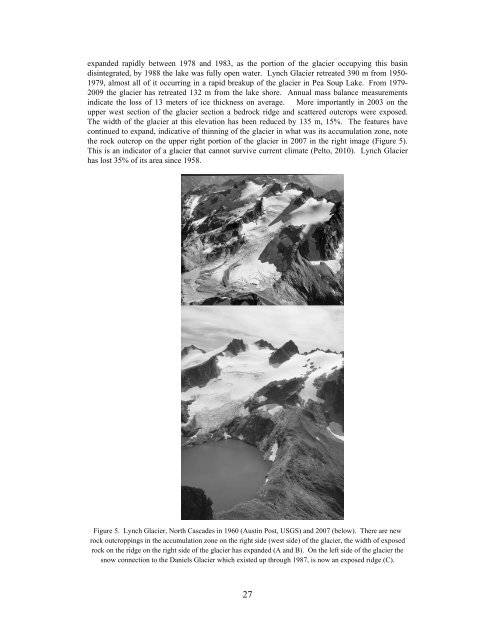
expanded rapidly between 1978 and 1983, as the porti<strong>on</strong> <str<strong>on</strong>g>of</str<strong>on</strong>g> the glacier occupying this basin<br />
disintegrated, by 1988 the lake was fully open water. Lynch <str<strong>on</strong>g>Glacier</str<strong>on</strong>g> retreated 390 m from 1950-<br />
1979, almost all <str<strong>on</strong>g>of</str<strong>on</strong>g> it occurring in a rapid breakup <str<strong>on</strong>g>of</str<strong>on</strong>g> the glacier in Pea Soup Lake. From 1979-<br />
2009 the glacier has retreated 132 m from the lake shore. Annual mass balance measurements<br />
indicate the loss <str<strong>on</strong>g>of</str<strong>on</strong>g> 13 meters <str<strong>on</strong>g>of</str<strong>on</strong>g> ice thickness <strong>on</strong> average. More importantly in 2003 <strong>on</strong> the<br />
upper west secti<strong>on</strong> <str<strong>on</strong>g>of</str<strong>on</strong>g> the glacier secti<strong>on</strong> a bedrock ridge and scattered outcrops were exposed.<br />
The width <str<strong>on</strong>g>of</str<strong>on</strong>g> the glacier at this elevati<strong>on</strong> has been reduced by 135 m, 15%. The features have<br />
c<strong>on</strong>tinued to expand, indicative <str<strong>on</strong>g>of</str<strong>on</strong>g> thinning <str<strong>on</strong>g>of</str<strong>on</strong>g> the glacier in what was its accumulati<strong>on</strong> z<strong>on</strong>e, note<br />
the rock outcrop <strong>on</strong> the upper right porti<strong>on</strong> <str<strong>on</strong>g>of</str<strong>on</strong>g> the glacier in 2007 in the right image (Figure 5).<br />
This is an indicator <str<strong>on</strong>g>of</str<strong>on</strong>g> a glacier that cannot survive current climate (Pelto, 2010). Lynch <str<strong>on</strong>g>Glacier</str<strong>on</strong>g><br />
has lost 35% <str<strong>on</strong>g>of</str<strong>on</strong>g> its area since 1958.<br />
Figure 5. Lynch <str<strong>on</strong>g>Glacier</str<strong>on</strong>g>, North Cascades in 1960 (Austin Post, USGS) and 2007 (below). There are new<br />
rock outcroppings in the accumulati<strong>on</strong> z<strong>on</strong>e <strong>on</strong> the right side (west side) <str<strong>on</strong>g>of</str<strong>on</strong>g> the glacier, the width <str<strong>on</strong>g>of</str<strong>on</strong>g> exposed<br />
rock <strong>on</strong> the ridge <strong>on</strong> the right side <str<strong>on</strong>g>of</str<strong>on</strong>g> the glacier has expanded (A and B). On the left side <str<strong>on</strong>g>of</str<strong>on</strong>g> the glacier the<br />
snow c<strong>on</strong>necti<strong>on</strong> to the Daniels <str<strong>on</strong>g>Glacier</str<strong>on</strong>g> which existed up through 1987, is now an exposed ridge (C).<br />
27