M iddle Fk. American River - PCWA Middle Fork American River ...
M iddle Fk. American River - PCWA Middle Fork American River ...
M iddle Fk. American River - PCWA Middle Fork American River ...

Create successful ePaper yourself
Turn your PDF publications into a flip-book with our unique Google optimized e-Paper software.
A<br />
Y<br />
49<br />
AUBURN<br />
Folsom<br />
Lake<br />
11434000<br />
11427000<br />
(NFD)<br />
11433799<br />
11433800<br />
North <strong>Fork</strong> <strong>American</strong> Ri ver<br />
Lake<br />
Clementine<br />
11433500<br />
174<br />
80<br />
49<br />
11433420<br />
M<strong>iddle</strong> For k <strong>American</strong> <strong>River</strong><br />
South <strong>Fork</strong> Ame r ican Rive r<br />
11433300<br />
(OXB)<br />
Oxbow P.H.<br />
Ralston Afterbay Dam<br />
Z:\GIS\Entrix\3116501\map\RecreationMaps\REC4 Maps\<strong>PCWA</strong>_MFAR_Wshed_FlowGages_17i11i_01.mxd<br />
11426500<br />
FORESTHILL<br />
11433400<br />
11433212<br />
11427765<br />
Ralston<br />
Afterbay<br />
Ralston P.H.<br />
Otter Creek<br />
Canyon Cr ek<br />
P-F1<br />
P-F2<br />
193<br />
P-F3<br />
Ralston - Oxbow Tunnel<br />
Oxbow<br />
P.H.<br />
11433300<br />
(OXB)<br />
Ralston Afterbay<br />
Dam<br />
11433260<br />
11433200<br />
11426400<br />
North For k o f M <strong>iddle</strong> For k <strong>American</strong> <strong>River</strong><br />
Ralston<br />
Afterbay<br />
P-F4<br />
PLACERVILLE<br />
Ralston<br />
P.H.<br />
11433040<br />
Slab Creek<br />
Reservoir<br />
Nor th <strong>Fork</strong> <strong>American</strong> <strong>River</strong><br />
Interbay<br />
Dam<br />
11427770<br />
M<strong>iddle</strong> <strong>Fork</strong><br />
Interbay<br />
Long Canyon<br />
M<strong>iddle</strong> <strong>Fork</strong><br />
P.H.<br />
M<strong>iddle</strong> <strong>Fork</strong> - Ralston Tunnel<br />
11432000<br />
11432500<br />
11427760<br />
11428600<br />
Stumpy Meadows<br />
Reservoir<br />
Duncan Creek Diversion<br />
Ru bicon <strong>River</strong><br />
11431800<br />
Silver Creek<br />
Duncan Creek<br />
SF-4<br />
11433080<br />
11433085<br />
N.<br />
11433100<br />
11427750<br />
P-F5<br />
<strong>Fk</strong>. Long Canyon<br />
S. <strong>Fk</strong>.<br />
Pilo t C reek<br />
11427500<br />
French Meadows<br />
Reservoir French Meadows - Hell Hole Tunnel<br />
French Meadows<br />
Dam<br />
SF-3<br />
11427200 Hell Hole<br />
11433060 11428800 Reservoir<br />
11433065<br />
Hell Hole<br />
Dam<br />
SF-5<br />
Hell Hole<br />
P.H.<br />
Long Canyon<br />
North <strong>Fork</strong> Long Canyon<br />
Diversion<br />
Hell Hole - M<strong>iddle</strong> <strong>Fork</strong> Tunnel<br />
P-F6<br />
P-F7<br />
11431000<br />
11427700<br />
11431500<br />
South <strong>Fork</strong> Long Canyon<br />
Diversion<br />
11430500<br />
11430000<br />
11429300<br />
Union Valley<br />
Reservoir<br />
South <strong>Fork</strong> Am erican <strong>River</strong><br />
M<strong>iddle</strong> <strong>Fork</strong> <strong>American</strong> <strong>River</strong><br />
Duncan Creek - M<strong>iddle</strong> <strong>Fork</strong> Tunnel<br />
SF-1<br />
French Meadows<br />
P.H.<br />
SF-2<br />
South <strong>Fork</strong> Rubicon <strong>River</strong><br />
11429000<br />
B a s s i <strong>Fork</strong><br />
Fiv e Lakes Creek<br />
Loon Lake<br />
11429340<br />
11429800<br />
11429500<br />
Ice House<br />
Reservoir<br />
Rubicon <strong>River</strong><br />
Si lv er Cr eek<br />
11428400<br />
11428300<br />
11428001<br />
11428000<br />
South F o rk Silver Creek<br />
89<br />
11427960<br />
11427940<br />
B<br />
168<br />
B<br />
B<br />
Lake<br />
Tahoe<br />
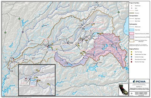
Project Facilities<br />
Date: 5/26/10<br />
Powerhouse<br />
Dam<br />
Tunnel<br />
Penstock<br />
Transportation<br />
Hydrography<br />
Major Road<br />
Minor Road<br />
Watercourse<br />
Water Body<br />
Gaging Stations<br />
Watershed Influenced by SMUD<br />
Watershed Influenced by GDPUD<br />
M<strong>iddle</strong> <strong>Fork</strong> <strong>American</strong> <strong>River</strong><br />
Watershed*<br />
*Modified from Calwater Ver. 2.2 to represent<br />
drainage above high-water mark of Folsom Lake<br />
New Flow Gage<br />
Supplemental Flow Gage<br />
Existing Flow Gage<br />
Discontinued Flow Gage<br />
Real-time Flow Gage<br />
Placer County Water Agency<br />
M<strong>iddle</strong> <strong>Fork</strong> <strong>American</strong> <strong>River</strong> Project<br />
Map REC 4-17<br />
Gaging Station Locations in the Vicinity<br />
of the M<strong>iddle</strong> <strong>Fork</strong> <strong>American</strong> <strong>River</strong> Project<br />
0 5<br />
Miles<br />
Projection: CA State Plane, Zone 2<br />
Datum: NAD 83