M iddle Fk. American River - PCWA Middle Fork American River ...
M iddle Fk. American River - PCWA Middle Fork American River ...
M iddle Fk. American River - PCWA Middle Fork American River ...

Create successful ePaper yourself
Turn your PDF publications into a flip-book with our unique Google optimized e-Paper software.
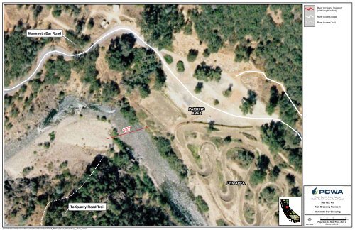
Mammoth Bar Road<br />
To Quarry Road Trail<br />
Z:\GIS\Entrix\3116501\map\RecreationMaps\REC4 Maps\<strong>PCWA</strong>_PeakingReach_StreamXings_17i11i_01.mxd<br />
177'<br />
PARKING<br />
AREA<br />
OHV AREA<br />
B<br />
168<br />
B<br />
B<br />
Date: 5/25/10<br />
<strong>River</strong> Crossing Transect<br />
(with length in feet)<br />
<strong>River</strong> Access Road<br />
<strong>River</strong> Access Trail<br />
Placer County Water Agency<br />
M<strong>iddle</strong> <strong>Fork</strong> <strong>American</strong> <strong>River</strong> Project<br />
Map REC 4-5<br />
Trail Crossing Transect<br />
Mammoth Bar Crossing<br />
0 25 50 100<br />
Feet<br />
Projection: CA State Plane, Zone 2<br />
Datum: NAD 83