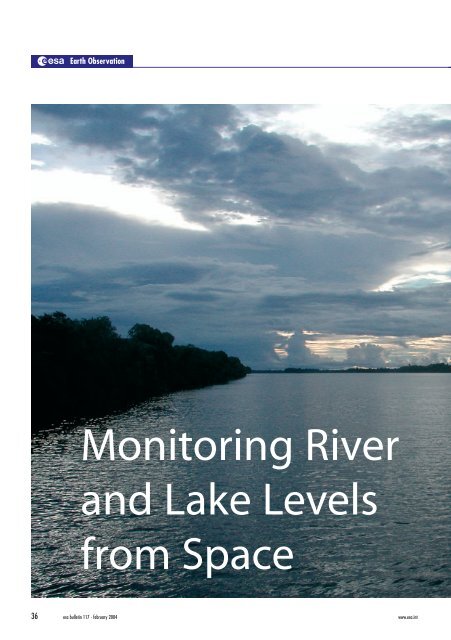
Monitoring River and Lake Levels from Space - ESA
Monitoring River and Lake Levels from Space - ESA
Monitoring River and Lake Levels from Space - ESA

You also want an ePaper? Increase the reach of your titles
YUMPU automatically turns print PDFs into web optimized ePapers that Google loves.
Earth Observation<br />
<strong>Monitoring</strong> <strong>River</strong><br />
<strong>and</strong> <strong>Lake</strong> <strong>Levels</strong><br />
<strong>from</strong> <strong>Space</strong><br />
36 esa bulletin 117 - february 2004 www.esa.int
The growing concern about our planet’s water resources,<br />
coupled with the economically driven decrease in groundbased<br />
gauge measurements, has focused attention on the<br />
possibility of using space-based data sets for remote<br />
measurements of river <strong>and</strong> lake heights. The most direct<br />
measurements of inl<strong>and</strong> water heights are obtained <strong>from</strong><br />
satellite altimeters, with long time series of such observations<br />
having been built up over the past decade.<br />
<strong>ESA</strong> has been developing new global river <strong>and</strong> lake monitoring<br />
products, including an expert processing system, with the help<br />
of De Montfort University (UK). A seven-year-long time<br />
series of samples was distributed to the hydrology community<br />
at the CNES Hydrology <strong>from</strong> <strong>Space</strong> Workshop in Toulouse last<br />
October in order to validate the user requirements. They<br />
responded very favorably <strong>and</strong> are now impatient to get their<br />
h<strong>and</strong>s on a decade of global river- <strong>and</strong> lake-level products, as<br />
well as the latest near-real-time products coming <strong>from</strong> <strong>ESA</strong>’s<br />
Envisat mission.<br />
© Ilce Campos<br />
<strong>River</strong>s <strong>and</strong> <strong>Lake</strong>s<br />
Jérôme Benveniste<br />
Earth Observation Science <strong>and</strong> Applications Department,<br />
<strong>ESA</strong> Directorate of Earth Observation, ESRIN, Frascati, Italy<br />
Philippa Berry<br />
De Montfort University, Leicester, United Kingdom<br />
The great majority of the World's population<br />
lives alongside, <strong>and</strong> is often dependent upon,<br />
continental water bodies. Inl<strong>and</strong> water bodies<br />
– rivers, lakes, wetl<strong>and</strong>s <strong>and</strong> floodplains – play<br />
important roles in a variety of interdisciplinary<br />
applications. They are a source of both water <strong>and</strong><br />
protein, often a means of navigation <strong>and</strong> for the<br />
production of hydroelectric power, <strong>and</strong> have been<br />
shown to be good proxy indicators of local <strong>and</strong> regional<br />
climatic change. Many catchment areas are regions of<br />
great biodiversity <strong>and</strong> are often focal points in terms of<br />
environmental <strong>and</strong> conservation issues. Routine<br />
monitoring of these basins has further importance for<br />
regional <strong>and</strong> continental-scale hydrological,<br />
biochemical <strong>and</strong> climatological studies concerning, for<br />
example, the measurement of river discharges, the<br />
production of wetl<strong>and</strong> methane, <strong>and</strong> the estimation of<br />
evaporation losses for l<strong>and</strong>/atmosphere interactions.<br />
Changes in the stored volumes of surface water also<br />
have geodynamical implications for the Earth’s rotation<br />
<strong>and</strong> gravity, <strong>and</strong> for estimating the global water mass in<br />
relation to sea-level changes. With synergistic<br />
inundation extent measured by remote-sensing<br />
imagers, radar or optical, the monitoring of both<br />
surface level <strong>and</strong> area has relevance for studies of<br />
water-related epidemics such as malaria, cholera, <strong>and</strong><br />
tuberculosis <strong>and</strong> the financial losses <strong>and</strong> human<br />
suffering there<strong>from</strong>.<br />
www.esa.int esa bulletin 117 - february 2004 37
The Rationale<br />
Earth Observation<br />
<strong>ESA</strong>’s ERS-1 <strong>and</strong> ERS-2 missions <strong>and</strong> the<br />
Topex/Poseidon satellite have been<br />
acquiring radar-altimeter data for more<br />
than ten years now. With the recent<br />
successful launch of Jason-1 <strong>and</strong> <strong>ESA</strong>’s<br />
Envisat, this time series will be prolonged<br />
into the future, as well as being processed<br />
in near real time. It means that there is a<br />
wealth of long-term hydrological<br />
information at h<strong>and</strong>, but extracting<br />
meaningful products <strong>from</strong> the radaraltimeter<br />
signal echoes is a complex<br />
process due to the unpredictable nature of<br />
the echo’s shape over continental surfaces.<br />
This is precisely why <strong>ESA</strong> launched the<br />
development of a new ready-to-use<br />
hydrological product as part of its ‘<strong>River</strong><br />
<strong>and</strong> <strong>Lake</strong> Project’.<br />
The project’s main objective is to<br />
provide the scientific community with<br />
easy-to-use, effective <strong>and</strong> accurate river<br />
<strong>and</strong> lake level measurements <strong>from</strong> both the<br />
ERS <strong>and</strong> Envisat satellite altimeters. The<br />
hydrologist’s requirements pose a very<br />
interesting challenge, because the<br />
traditional satellite products have been<br />
radically different <strong>from</strong> those based on<br />
ground data, with both the vertical<br />
precision <strong>and</strong> temporal sampling being<br />
more limited.<br />
This new development will enable the<br />
valuable hydrological data encoded in<br />
satellite altimeter echoes returned <strong>from</strong><br />
rivers <strong>and</strong> lakes to be translated into<br />
accurate height estimates, thus permitting<br />
time series of more exact water heights to<br />
be produced. Of the many potential<br />
applications of radar altimetry to<br />
hydrology, the simplest in concept is the<br />
monitoring of river <strong>and</strong> lake levels.<br />
Previous work on extracting such<br />
information <strong>from</strong> satellite data was<br />
constrained by mission limitations (Seasat)<br />
<strong>and</strong> a combination of data limitations <strong>and</strong><br />
instrument <strong>and</strong> pointing difficulties over<br />
l<strong>and</strong> surfaces (Geosat). This meant that<br />
only very limited applications of altimetry<br />
for surface hydrology could be<br />
demonstrated over l<strong>and</strong>, with the primary<br />
targets being wetl<strong>and</strong>s (for direct mapping)<br />
<strong>and</strong> large lakes (for water-level<br />
determination).<br />
38 esa bulletin 117 - february 2004<br />
Considerable work has been done with<br />
Topex, which has also demonstrated the<br />
usefulness of such data, but only over a<br />
small number of selected targets. One key<br />
constraint for hydrological applications<br />
<strong>from</strong> these missions is that their altimeters,<br />
originally designed for ocean measurements,<br />
can ‘keep track’ only over very<br />
limited areas on l<strong>and</strong>.<br />
The major advance in l<strong>and</strong> coverage<br />
provided by the inclusion of an ‘ice mode’<br />
in the ERS-1 <strong>and</strong> ERS-2 Radar Altimeters<br />
has vastly increased the capabilities for<br />
monitoring the Earth’s river <strong>and</strong> lake<br />
systems, compared with altimeters<br />
equipped only with an ‘ocean mode’, e.g.<br />
Topex/Poseidon <strong>and</strong> Geosat Follow-On.<br />
Envisat will both continue<br />
The Amazon <strong>River</strong> Basin<br />
observed with the ERS-1<br />
Radar Altimeter<br />
this valuable data stream <strong>and</strong>, potentially,<br />
extend it, as an additional tracking mode<br />
allows successful radar-echo capture over<br />
even rougher terrain.<br />
The system developed by De Montfort<br />
University (UK) for <strong>ESA</strong> uses both ERS<br />
<strong>and</strong> Envisat data to produce two types of<br />
products: a <strong>River</strong>-<strong>Lake</strong> Hydrology (RLH)<br />
product <strong>and</strong> a <strong>River</strong>-<strong>Lake</strong> Altimetry (RLA)<br />
product. The first goal is to obtain 7 years<br />
of processed data for specific targets, then<br />
to propose the world-wide coverage of<br />
large rivers <strong>and</strong> lakes over 7 years, <strong>and</strong><br />
finally to make all RLH <strong>and</strong> RLA products<br />
available to hydrologists in near-real-time,<br />
i.e. less than 3 hours after the satellite’s<br />
overflight.
The Role of Satellite Radar Altimetry<br />
Water bodies represent important economic <strong>and</strong> cultural resources, but also much economic<br />
activity <strong>and</strong> development takes place close to the shorelines of lakes <strong>and</strong> can be adversely<br />
affected by flooding. Moreover, lake volumes respond to changes in precipitation integrated<br />
over their catchment basins <strong>and</strong> so can act as important, though indirect, indicators of climate<br />
change on both regional <strong>and</strong> global scales. Major river systems are important targets for<br />
research covering a wide range of applications, such as transport, flooding hazards, water <strong>and</strong><br />
food resource management, as well as studies of the hydrological cycle <strong>and</strong> the impact of l<strong>and</strong><br />
use <strong>and</strong> climate change.<br />
For certain major rivers <strong>and</strong> wetl<strong>and</strong>s, hydrological information can often be difficult to obtain,<br />
due to the inaccessibility of the region, the sparse distribution of gauge stations, or the slow<br />
dissemination of data. Satellite radar altimeters have the potential to provide accurate height<br />
measurements not only for lakes, but also for large rivers such as the Amazon, which has been<br />
a primary target of environmental studies over the last 10 years.<br />
Research into the application of altimetry for monitoring river <strong>and</strong> lake levels has been carried<br />
out since 1982. It has highlighted the advantages of using data derived <strong>from</strong> satellites due to<br />
their global coverage <strong>and</strong> regular temporal sampling of the processed data, but has also<br />
identified the difficulties in interpreting radar-altimeter measurements made over inl<strong>and</strong><br />
waters. In general, the great improvement in altimeter measurement accuracy that has<br />
occurred over the past decade has been due to the progress in altimeter instrumentation,<br />
coupled with the substantial improvement in the precision of satellite orbit calculations.<br />
Satellite altimetry coverage over l<strong>and</strong> surfaces has also been greatly improved due to the<br />
inclusion by <strong>ESA</strong> of additional tracking modes in the ERS <strong>and</strong> Envisat altimeters, which<br />
enable these instruments to cope with rapidly changing surfaces, leading to<br />
substantial advances in the study of ice, l<strong>and</strong> <strong>and</strong> inl<strong>and</strong> waters.<br />
Topex Ku Ocean 00N 150W<br />
A C<br />
Sifting the Data<br />
<strong>River</strong>s <strong>and</strong> <strong>Lake</strong>s<br />
To optimise the recovery of inl<strong>and</strong> water<br />
data <strong>from</strong> spaceborne altimeters, <strong>and</strong> gain<br />
access to the unique time series of inl<strong>and</strong><br />
water heights contained in the ERS <strong>and</strong><br />
Envisat radar signals, it is necessary to<br />
reprocess the individual echoes to obtain<br />
an accurate ‘range to surface’. The task is<br />
complicated by the wide variety of echo<br />
shapes returned, especially in the presence<br />
of l<strong>and</strong> ‘contamination’. In fact, several<br />
factors affect the accurate recovery of<br />
height data <strong>from</strong> inl<strong>and</strong> water echoes. The<br />
first <strong>and</strong> in many ways the most serious<br />
limitation is the presence of very bright<br />
components within the echo resulting <strong>from</strong><br />
still pools. Further complications include<br />
the presence of isl<strong>and</strong>s <strong>and</strong> s<strong>and</strong>bars within<br />
the water body, the surrounding still water<br />
<strong>from</strong>, for example, irrigation <strong>and</strong> rice<br />
paddies, <strong>and</strong> the effect of surrounding<br />
terrain. All of these factors affect the echo<br />
shape <strong>and</strong> complicate retrieval of the range<br />
<strong>from</strong> the satellite to the water surface.<br />
The accompanying figure shows four<br />
sequences of echo shapes to illustrate the<br />
differences between the echoes <strong>from</strong> large<br />
lakes <strong>and</strong> oceans, <strong>and</strong> the rapidly varying<br />
radar returns <strong>from</strong> rivers <strong>and</strong> smaller lake<br />
systems: they are typical ocean returns<br />
<strong>from</strong> Topex, returns <strong>from</strong> Envisat over a<br />
large lake (<strong>Lake</strong> Titicaca), <strong>and</strong> two series<br />
Envisat Ku <strong>Lake</strong> Titicata Topex Ku Amazon 15S 075W<br />
B D<br />
ERS Ice-Mode Water Echoes Amazon<br />
Envisat Radar Altimeter return-echo shapes over rivers<br />
esa bulletin 117 - february 2004 39
Earth Observation<br />
In this illustration, lakes seen by both ERS-2 <strong>and</strong><br />
Topex are shown in orange, lakes seen only by<br />
ERS-2 are in green, lakes not seen by either<br />
satellite are in blue, <strong>and</strong> three small lakes<br />
overflown only by Topex are shown in cyan. This<br />
dramatic difference in coverage is a consequence<br />
of the orbit patterns <strong>and</strong> the additional icetracking<br />
mode of the ERS Radar Altimeters<br />
of returns <strong>from</strong> inl<strong>and</strong> water/l<strong>and</strong><br />
composites over the Amazon Basin <strong>from</strong><br />
ERS-2 <strong>and</strong> Topex. This diversity in echo<br />
shapes means that it has not been possible<br />
to design just one retracking algorithm to<br />
reprocess all waveforms optimally. Rather,<br />
a suite of such algorithms is required, <strong>and</strong><br />
this is the approach that has been<br />
implemented for ERS-1/2, Envisat <strong>and</strong><br />
Topex data using the expert system<br />
developed at De Montfort University.<br />
Over rivers, ERS-2 shows significantly<br />
better performance than Topex, thanks to<br />
the Ice mode. The accompanying figure<br />
shows a typical 35-day cycle of ERS-2<br />
crossings (green) superimposed on the<br />
Amazon Basin bright-targets map developed<br />
<strong>from</strong> the ERS-1 geodetic mission (red).<br />
Four sample time series of river-height<br />
variations derived <strong>from</strong> the ERS-2<br />
retracked dataset are also shown. The large<br />
annual variation is clear.<br />
ERS-2 35-day crossings over the Amazon <strong>and</strong> samples of time<br />
series of river levels<br />
To illustrate the relative performance of<br />
a higher sampling frequency with an icemode<br />
altimeter, the next figure shows a<br />
similar map for ERS-2 three-day crossings<br />
(green) over Amazon Basin bright targets.<br />
Again, time-series data have been included<br />
to illustrate the satellite altimetry’s<br />
potential for identifying rapid temporal<br />
variations in river <strong>and</strong> stream height when<br />
using a satellite with a short orbit-repeat<br />
pattern.<br />
40 esa bulletin 117 - february 2004 www.esa.int
The Two New Products<br />
As mentioned above, two novel types of<br />
product have been designed <strong>and</strong> are<br />
currently available as samples. The <strong>River</strong>-<br />
<strong>Lake</strong> Hydrology (RLH) product, intended<br />
for hydrologists with no special knowledge<br />
of radar altimetry, is grouped by river/lake<br />
crossing point (one product per crossing<br />
point). The RLH product is distributed in<br />
XML format, which makes access <strong>and</strong><br />
visualisation very simple. The <strong>River</strong>-<strong>Lake</strong><br />
Altimetry (RLA) product, designed for<br />
radar-altimetry experts, is grouped by<br />
satellite orbital revolution. A detailed<br />
product description can be found in the<br />
Product H<strong>and</strong>book, downloadable <strong>from</strong><br />
the <strong>River</strong> <strong>and</strong> <strong>Lake</strong> Project web site<br />
(http://earth.esa.int/river<strong>and</strong>lake).<br />
To familiarise the hydrology community<br />
with these novel products <strong>and</strong> to gather<br />
feedback concerning their suitability <strong>and</strong><br />
use, a set of 22 representative seven-yearlong<br />
time-series samples were distributed<br />
at the Hydrology <strong>from</strong> <strong>Space</strong> Workshop in<br />
Toulouse (F) last October. The 22 products<br />
focused on two regions:<br />
– Africa: <strong>Lake</strong> Nasser, the <strong>River</strong> Nile<br />
including the Aswan Dam, <strong>Lake</strong> Tana,<br />
<strong>Lake</strong> Kyoga, <strong>Lake</strong> Victoria, <strong>Lake</strong> Mai-<br />
Ndombe <strong>and</strong> the <strong>River</strong> Congo.<br />
– South America: Amazon Basin.<br />
ERS-1 3-day crossings over the Amazon Basin <strong>and</strong> samples<br />
of time-series river-level data<br />
The <strong>River</strong> Congo as seen by Envisat’s Advanced<br />
Synthetic Aperture Radar (ASAR)<br />
The accompanying location<br />
maps for both regions have the<br />
related product crossing points<br />
highlighted <strong>and</strong> the corresponding<br />
product samples can be<br />
downloaded at http:// earth.esa.<br />
int/river<strong>and</strong>lake.<br />
<strong>River</strong>s <strong>and</strong> <strong>Lake</strong>s<br />
Maps of the African <strong>and</strong> South American sample-product locations<br />
www.esa.int esa bulletin 117 - february 2004 41
Earth Observation<br />
The shrinking Aral Sea, as seen by Envisat's MERIS instrument.<br />
Its water level has dropped 13 metres since the 1960's<br />
Sample products over the<br />
<strong>River</strong> Amazon, which clearly<br />
show not only the annual cycle<br />
in water level, but also the<br />
year-to-year variation, which<br />
have both ecological <strong>and</strong><br />
climatological consequences<br />
The accompanying graph is a<br />
quantitative representation of the products<br />
over the <strong>River</strong> Amazon, showing the<br />
variation <strong>from</strong> the mean water level in the<br />
river at two crossing points. The annual<br />
cycle is clearly visible in this seven-year<br />
time series of data. The year-to-year<br />
variation in the annual cycle, which is of<br />
major importance for climatological<br />
studies, is also clearly detected.<br />
Three New Processing Tools<br />
To help the hydrology community to<br />
access <strong>and</strong> process the two new products,<br />
software tools have also been developed<br />
<strong>and</strong> made available. A software library,<br />
written in the C programming language,<br />
helps users to incorporate the reading/<br />
writing of RLA products into their own<br />
programs. A new Graphical User Interface<br />
tool realised in IDL (Interactive Data<br />
Language) facilitates the plotting of both<br />
the RLA <strong>and</strong> RLH products. An RLH<br />
Demonstration Viewer, written in Java <strong>and</strong><br />
therefore platform-independent, allows<br />
scatter, line <strong>and</strong> area plots to be made of<br />
more than one RLH product at a time. The<br />
<strong>River</strong>-<strong>Lake</strong> Viewer also includes a zoom<br />
facility <strong>and</strong> the possibility to export plots<br />
in Portable Network Graphics format.<br />
Future Plans<br />
Whilst the decade-long archive of satellite<br />
data is being processed, more samples for<br />
other geographical regions, focusing on<br />
specific user needs, will be prepared <strong>and</strong><br />
distributed next April. The Envisat ground<br />
segment will be enhanced with the nearreal-time<br />
river <strong>and</strong> lake level processor to<br />
provide products to the hydrology community<br />
in less than three hours after<br />
measurement. A second Hydrology <strong>from</strong><br />
<strong>Space</strong> Workshop will be organised next<br />
year, as was strongly recommended by the<br />
participants in the first workshop, along<br />
with the establishment of a European<br />
scientific working group on Hydrological<br />
Observations <strong>from</strong> <strong>Space</strong>. The Working<br />
Group’s objective is to promote the<br />
application of existing space observations<br />
to problems in hydrology <strong>and</strong> formulate<br />
the requirements for future spaceborne<br />
hydrology missions, as well as to organise<br />
the necessary ground-based observations<br />
to support the validation of the space-data<br />
products. The Working Group will also<br />
promote communication between <strong>ESA</strong> <strong>and</strong><br />
the scientific communities represented<br />
within its membership. s<br />
42 esa bulletin 117 - february 2004 www.esa.int