Monitoring River and Lake Levels from Space - ESA
Monitoring River and Lake Levels from Space - ESA
Monitoring River and Lake Levels from Space - ESA

You also want an ePaper? Increase the reach of your titles
YUMPU automatically turns print PDFs into web optimized ePapers that Google loves.
The Role of Satellite Radar Altimetry<br />
Water bodies represent important economic <strong>and</strong> cultural resources, but also much economic<br />
activity <strong>and</strong> development takes place close to the shorelines of lakes <strong>and</strong> can be adversely<br />
affected by flooding. Moreover, lake volumes respond to changes in precipitation integrated<br />
over their catchment basins <strong>and</strong> so can act as important, though indirect, indicators of climate<br />
change on both regional <strong>and</strong> global scales. Major river systems are important targets for<br />
research covering a wide range of applications, such as transport, flooding hazards, water <strong>and</strong><br />
food resource management, as well as studies of the hydrological cycle <strong>and</strong> the impact of l<strong>and</strong><br />
use <strong>and</strong> climate change.<br />
For certain major rivers <strong>and</strong> wetl<strong>and</strong>s, hydrological information can often be difficult to obtain,<br />
due to the inaccessibility of the region, the sparse distribution of gauge stations, or the slow<br />
dissemination of data. Satellite radar altimeters have the potential to provide accurate height<br />
measurements not only for lakes, but also for large rivers such as the Amazon, which has been<br />
a primary target of environmental studies over the last 10 years.<br />
Research into the application of altimetry for monitoring river <strong>and</strong> lake levels has been carried<br />
out since 1982. It has highlighted the advantages of using data derived <strong>from</strong> satellites due to<br />
their global coverage <strong>and</strong> regular temporal sampling of the processed data, but has also<br />
identified the difficulties in interpreting radar-altimeter measurements made over inl<strong>and</strong><br />
waters. In general, the great improvement in altimeter measurement accuracy that has<br />
occurred over the past decade has been due to the progress in altimeter instrumentation,<br />
coupled with the substantial improvement in the precision of satellite orbit calculations.<br />
Satellite altimetry coverage over l<strong>and</strong> surfaces has also been greatly improved due to the<br />
inclusion by <strong>ESA</strong> of additional tracking modes in the ERS <strong>and</strong> Envisat altimeters, which<br />
enable these instruments to cope with rapidly changing surfaces, leading to<br />
substantial advances in the study of ice, l<strong>and</strong> <strong>and</strong> inl<strong>and</strong> waters.<br />
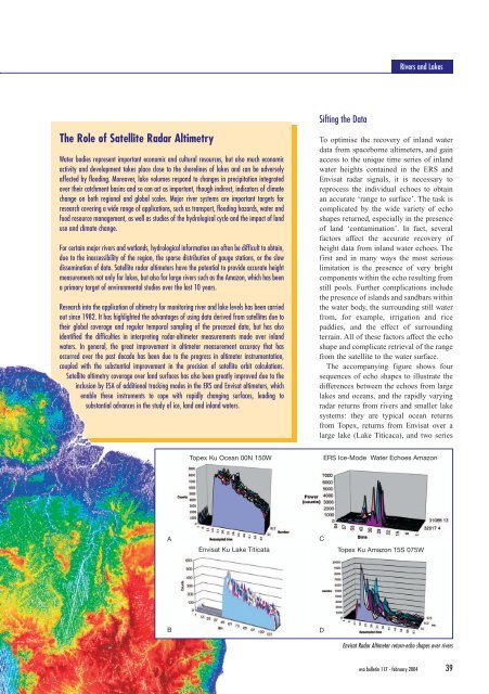
Topex Ku Ocean 00N 150W<br />
A C<br />
Sifting the Data<br />
<strong>River</strong>s <strong>and</strong> <strong>Lake</strong>s<br />
To optimise the recovery of inl<strong>and</strong> water<br />
data <strong>from</strong> spaceborne altimeters, <strong>and</strong> gain<br />
access to the unique time series of inl<strong>and</strong><br />
water heights contained in the ERS <strong>and</strong><br />
Envisat radar signals, it is necessary to<br />
reprocess the individual echoes to obtain<br />
an accurate ‘range to surface’. The task is<br />
complicated by the wide variety of echo<br />
shapes returned, especially in the presence<br />
of l<strong>and</strong> ‘contamination’. In fact, several<br />
factors affect the accurate recovery of<br />
height data <strong>from</strong> inl<strong>and</strong> water echoes. The<br />
first <strong>and</strong> in many ways the most serious<br />
limitation is the presence of very bright<br />
components within the echo resulting <strong>from</strong><br />
still pools. Further complications include<br />
the presence of isl<strong>and</strong>s <strong>and</strong> s<strong>and</strong>bars within<br />
the water body, the surrounding still water<br />
<strong>from</strong>, for example, irrigation <strong>and</strong> rice<br />
paddies, <strong>and</strong> the effect of surrounding<br />
terrain. All of these factors affect the echo<br />
shape <strong>and</strong> complicate retrieval of the range<br />
<strong>from</strong> the satellite to the water surface.<br />
The accompanying figure shows four<br />
sequences of echo shapes to illustrate the<br />
differences between the echoes <strong>from</strong> large<br />
lakes <strong>and</strong> oceans, <strong>and</strong> the rapidly varying<br />
radar returns <strong>from</strong> rivers <strong>and</strong> smaller lake<br />
systems: they are typical ocean returns<br />
<strong>from</strong> Topex, returns <strong>from</strong> Envisat over a<br />
large lake (<strong>Lake</strong> Titicaca), <strong>and</strong> two series<br />
Envisat Ku <strong>Lake</strong> Titicata Topex Ku Amazon 15S 075W<br />
B D<br />
ERS Ice-Mode Water Echoes Amazon<br />
Envisat Radar Altimeter return-echo shapes over rivers<br />
esa bulletin 117 - february 2004 39