Final ESR - Part 2 - Eskom
Final ESR - Part 2 - Eskom
Final ESR - Part 2 - Eskom

Create successful ePaper yourself
Turn your PDF publications into a flip-book with our unique Google optimized e-Paper software.
REVISED FINAL ENVIRONMENTAL SCOPING REPORT FOR THE PROPOSED COMBINED CYCLE GAS<br />
TURBINE (CCGT) POWER PLANT IN THE AMERSFOORT AREA, MPUMALANGA PROVINCE<br />
been attempted, to establish the possible cumulative impacts which may result from the<br />
proposed project.<br />
• Scoping Assessment<br />
During the scoping phase of this study, the key aspects of air pollution were identified and<br />
discussed for the construction, operational and decommissioning stages of the proposed<br />
project.<br />
8.1.3 Baseline Assessment<br />
• Wind<br />
For the proposed study area, both monitored meteorological data from the Underground Coal<br />
Gasification (UCG) plant and modelled data 5 from the South African Weather Services<br />
(SAWS) was made available. According to the SAWS modelled meteorological data, winds<br />
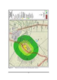
originate predominantly from the eastern and western sectors (Figure 4.4c – Chapter 4).<br />
Airflow in the study area is predominantly from the east (~15% of the time). From the eastern<br />
vector wind speeds of between 3.7 and 5.8 m/s occur most of the time (~6%). Wind speeds<br />
between 5.7 and 8.8 m/s also occur, but less frequently (~2%). Winds are westerly ~12% of<br />
the time, with the wind speed most frequently between 3.8 and 5.7 m/s (~4%). Wind speeds<br />
of greater than 8.8 m/s are also experienced infrequently in association with wind from the<br />
west. According to the frequency distribution graph presented in Figure 4.4d (Chapter 4), low<br />
wind speeds between 0.5 and 2.1 m/s occur most of the time.<br />
In comparison, the monitored data from the UCG site (Figure 4.4a and Figure 4.4b – Chapter<br />
4), also indicates winds predominating from the east and west but with wind speeds most<br />
commonly between 3.8 and 5.7 m/s. This will result in a higher dispersion potential when<br />
assessing the impacts due to the release of pollutants to the atmosphere, than would be case<br />
when assessing impacts using the SAWS modelled data.<br />
• Precipitation<br />
The area under investigation lies in the summer rainfall region of South Africa, receiving a<br />
total annual rainfall of 1008 mm. The seasonality of the rainfall for the area is outlined further<br />
in Chapter 4 – Section 4.1.2. of this report.<br />
• Temperature and Humidity<br />
Daily summer temperatures range between ~2 °C and ~32 °C with an average of ~17 °C.<br />
Winter temperatures range between ~ -8 °C and ~23 °C with an average of ~7 °C. The study<br />
area experiences high relative humidity during the summer months in excess of 70%.<br />
5<br />
The Weather Services Unified Model was used for these purposes as hourly average data was required for use.<br />
POTENTIAL IMPACTS ON THE SOCIAL 84<br />
11/08/2008<br />
ENVIRONMENTAL