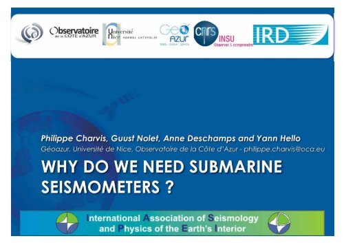
WHY DO WE NEED SUBMARINE SEISMOMETERS ? - ESONET NoE
WHY DO WE NEED SUBMARINE SEISMOMETERS ? - ESONET NoE
WHY DO WE NEED SUBMARINE SEISMOMETERS ? - ESONET NoE

Create successful ePaper yourself
Turn your PDF publications into a flip-book with our unique Google optimized e-Paper software.
Philippe Charvis, Guust Nolet, Anne Deschamps and Yann Hello<br />
Géoazur, Université de Nice, Observatoire de la Côte d’Azur - philippe.charvis@oca.eu<br />
<strong>WHY</strong> <strong>DO</strong> <strong>WE</strong> <strong>NEED</strong> <strong>SUBMARINE</strong><br />
<strong>SEISMOMETERS</strong>?
Global seismicity map<br />
Most earthquakes are located at plate boundaries<br />
85 % of the total seismic moment is released<br />
during large subduction earthquakes at active<br />
margins<br />
Cause of major hazard over densely populated<br />
costal areas
Ocean bottom seismometers exists since the 30’s<br />
One of the first OBS was deployed as early as 1937<br />
Many different types of OBSs exist but all of them are<br />
Free-fall portable instruments<br />
6 – 12 month autonomy<br />
HF to 120 sec. period sensors<br />
No control on coupling
Global network of permanent broadband seismic stations<br />
Lack of seismic stations in the oceans<br />
This lack is emphasized in the southern hemisphere
Global and local seismic tomography<br />
Mantle velocity at 2700 km 1300 km<br />
Equatorial cross-section Polarcross-section<br />
Traveltimes and<br />
waveforms of recorded<br />
seismograms are used to<br />
reconstruct 3D wave<br />
speed distribution in the<br />
earth<br />
Provides information on<br />
the composition, thermal<br />
structure and origin of our<br />
planet<br />
Red for low velocities<br />
(compare to an average<br />
model) and blue for high<br />
velocities<br />
Under-sampled regions in<br />
white<br />
The poor data coverage<br />
in southern hemisphere<br />
limits the quality of<br />
tomographic<br />
reconstruction
RESIF-EPOS an integrated seismic antenna<br />
Antares<br />
It is very unlikely that we will deploy tens of permanent sea bottom<br />
seismometers but this need could be achieved by temporary and long-term<br />
OBSs (several years of autonomy) with data transfer capabilities
RESIF-EPOS an integrated seismic antenna<br />
Antares<br />
It is very unlikely that we will deploy tens of permanent sea bottom<br />
seismometers but this need could be achieved by temporary and long-term<br />
OBSs (several years of autonomy) with data transfer capabilities
MERMAID drifting hydrophone buoys for global tomography<br />
A possible and cost effective<br />
solution to collect seismic data<br />
in the ocean<br />
Drifting hydrophone buoys<br />
that will serve as floating<br />
seismometers on the same<br />
principle as the sounding<br />
oceanographic Lagrangian<br />
buoys<br />
Detection of major<br />
earthquake and transmission<br />
of traveltimes<br />
ERC advanced grant<br />
Development, building and<br />
deployment of 8 drifting buoys<br />
equipped with an acoustic<br />
hydrophone (2009-2013)
Earthquake Early Warning (EEW) systems<br />
Continually process real-time seismic data to determine when a<br />
potentially damaging earthquake is underway<br />
Utilise the first arriving, low-amplitude P-waves to predict the<br />
impending arrival of the higher energy later arriving (e.g. Allen and<br />
Kanamori, 2003)<br />
Waves which actually cause damage typically occurs 10-500 s after a<br />
rupture starts, and even more for subduction earthquakes that<br />
typically start 50-150 km from the nearest (onshore) building<br />
The most advanced algorithms can differentiate between a relatively<br />
minor M6 earthquake and a catastrophic M7-9 earthquake using only<br />
the first few seconds’ worth of data<br />
Seafloor real-time seismic data would greatly improve our ability to<br />
differentiate between earthquakes that generate damaging tsunamis<br />
and earthquakes that do not generate tsunami<br />
Several groups in the US are starting to work on this… UC Berkeley,<br />
Woods Hole Oceanographic Institution
The French Riviera is an active<br />
area with a few large historical<br />
earthquakes of magnitude > 6.0<br />
The Antares neutrino telescope<br />
is connected to land through<br />
an opto-electrical cable<br />
providing<br />
Power<br />
Real-time data transmission<br />
In the deep basin (2400 m)<br />
The Antares neutrino telescope<br />
Submarine cable<br />
ANTARES
The French Riviera is an active<br />
area with a few large historical<br />
earthquakes of magnitude > 6.0<br />
The Antares neutrino telescope<br />
is connected to land through<br />
an opto-electrical cable<br />
providing<br />
Power<br />
Real-time data transmission<br />
In the deep basin (2400 m)<br />
The Antares neutrino telescope<br />
Submarine cable<br />
ANTARES<br />
23-2-1887 M~6.2
Broad band seismometer<br />
Guralp CMG 3T in specific<br />
titanium casing
Seismic noise at the sea bottom<br />
D<br />
N<br />
O<br />
S<br />
A<br />
J<br />
J<br />
M<br />
A<br />
M<br />
F<br />
J
Seismic noise at the sea bottom<br />
D<br />
N<br />
O<br />
S<br />
A<br />
J<br />
J<br />
M<br />
A<br />
M<br />
F<br />
J
Before burying<br />
After burying<br />
Relation between NS and EW motions<br />
Strong current Weak current<br />
The linearity indicates the tilt of seismometer is constant and allows correction<br />
of the seismic signal (Crawford et al.)
The Ligurian Sea submarine observatory
Geophysicists need permanent sea bottom observatories<br />
Real-time monitoring of earthquakes (landslides and tsunamis)<br />
Multi-sensors<br />
Broad band seismometers, accelerometers (strong motion), pressure gauge,<br />
tiltmeters,…<br />
Real-time data transmission for earthquake early warning<br />
Located at active zones (subduction,,…)<br />
Monitoring fluids and relation with seismic events and seismic activity<br />
Geodetic milestone for future underwater geodetic measurements<br />
(quantification of coupled fault segment)<br />
Ligurian submarine platform<br />
Test zone for the development of new technologies<br />
Local and global seismic imaging of the earth<br />
Fleet of drifting hydrophone buoys<br />
Long-term deployment of wide-band OBSs with increased autonomy (3<br />
years) and possibility of regular data recovering and instrument check
Why do we need submarine seismometers ? <br />
Philippe Charvis, Guust Nolet, Anne Deschamps and Yann Hello <br />
Géoazur, Observatoire de la Côte d’Azur, Université de Nice SophiaAntipolis, IRD, INSUCNRS <br />
Bât. 4, 250 rue Albert Einstein – Les Lucioles 1, Sophia Antipolis – 06560 Valbonne – France <br />
Tél : +33 492 94 26 92 – Email: philippe.charvis@oca.eu <br />
The seismic activity on the earth surface is located near the tectonic plate boundaries, most of them being in <br />
the deep ocean (expansion centers) or near their margins (subduction zones). Furthermore, 85% of the total <br />
amount of seismic moment is released during large earthquakes (M> 7.5 km/s) located at subduction zones. <br />
These large earthquakes cause major hazards over densely populated coastal areas. <br />
Very early in the history of seismology the need for sea‐bottom sensors was identified to improve <br />
localization of earthquakes. One of the first ocean bottom seismograph was deployed as early as 1937 <br />
(Ewing and Ewing, 1961). Sutton et al. (1965) emphasized the interest to conduct observations of seismic <br />
motion and other geophysical parameters on the ocean bottom over extended periods of time and over a <br />
wide range of frequencies. <br />
Seismic images of the deep earth <br />
Earthquakes generate seismic waves propagating through the earth that can be recorded by permanent <br />
seismic networks installed on continents and on some oceanic islands (e.g. the Global Seismographic <br />
Network consisting of 150 very broadband stations, distributed worldwide and capable of recording all <br />
seismic vibrations from local to large teleseismic events). <br />
Traveltimes and waveforms of recorded seismograms can be used to reconstruct the three‐dimensional <br />
wave speed distribution in the earth by a procedure known as seismic tomography or to image specific <br />
boundaries in the deep earth (core‐mantle boundary,…). This provides information on the composition, <br />
thermal structure and origin of our planet. Nevertheless, the unequal geographical repartition of stations, <br />
located only on continents and mostly in the northern hemisphere, leads to an unequal data coverage that <br />
limits the quality of tomographic reconstructions and images of the interior of the Earth (Fig. 1). <br />
Figure 1. A polar cross section through a P wave speed anomaly model (van der Hilst et al., 1997) shows undersampled <br />
regions in white. This highlights the poor resolution of mantle structure in the Southern Hemisphere and beneath major <br />
oceans due to the scarcity of seismic stations in the oceans. <br />
The study of oceanic lithosphere, of the ocean‐continent boundary, and of subduction zones is of major <br />
scientific, societal and economic interest. Because of the lack of permanent sea‐bottom seismometers these <br />
studies are conducted over short period of time (a few weeks to a few months at most) using portable ocean <br />
bottom seismometers. This approach is very restricting because of the limited period of recording, the poor <br />
coupling of the instruments with the sea‐bottom and the limited band‐width of sensors. <br />
Local and global seismic imaging of the earth needs long‐term and permanent deployment of wide‐band <br />
seismic sensors that will provide denser and more homogeneous data coverage. Ocean bottom <br />
seismometers and moored hydrophones are capable of addressing the coverage gap, but they are expensive <br />
to manufacture, deploy and maintain and cannot communicate their recordings without prohibitively <br />
expensive cabling. <br />
A possible solution to increase geographic data coverage for global tomography is the deployment of a <br />
number of drifting hydrophone buoys that will serve as floating seismometers on the same principle as the <br />
sounding oceanographic Lagrangian buoy. This type of instrument, providing an easy, cost‐effective way to <br />
collect seismic data in the ocean, was prototyped by Simons et al. (2006).
Real‐time monitoring of earthquakes <br />
Major earthquakes cause human and economic losses directly related to the strong motion of the ground or <br />
by induced phenomena like tsunamis and landslides. <br />
Early warning systems for tsunamis and earthquakes have been developed in the recent years to mitigate <br />
associated damages. For earthquakes early warning (EEW), systems continually process real‐time seismic <br />
data to determine when a potentially damaging earthquake is underway. They utilize the first arriving low‐<br />
amplitude P‐waves to predict the impending arrival of the higher energy later arriving waves, which actually <br />
cause damage. Subduction zone mega‐thrusts like 2004 Sumatra are great candidates for EEW because they <br />
typically start 50‐150 km from the nearest inhabited area, meaning there is several tens or hundreds of <br />
seconds to proceed with precautions, including shutting off gas lines and stopping trains. This can be <br />
achieved only with dedicated cabled sea‐bottom observatories that can transmit the seismic signal real‐time <br />
to processing centers. <br />
Nevertheless for academic purposes the access to the data in almost real‐time is also important to check if <br />
the instrument is operating properly, to adapt the multi‐sensors acquisition scheme to the variation of a <br />
parameter. For example, a near real time connection to shore, allowing transmission of at least a subset of <br />
the data will allow the possibility to modify acquisition parameters for other sensors (avalanche sensors,…). <br />
The Ligurian underwater scientific platform <br />
Figure 2: view of the Antares CMG3T seismometer during its installation by <br />
ROV Victor of Ifremer. <br />
The Antares neutrino telescope, installed in the Ligurian Sea, is <br />
connected to land through an opto‐electrical cable that provides <br />
power and data transmission from the coast to the deep basin <br />
(Aguilar et al., 2007). Using this opportunity, we installed in 2005 a <br />
broadband CMG3T seismological sensor specifically designed for <br />
this experiment that was used to test the technology and the <br />
installation of the sensor (Deschamps et al. 2003). <br />
In the next years, a more ambitious project is to install several <br />
sensors for earthquakes, slope instabilities and submarine avalanches offshore Nice, interconnected to the <br />
Antares telescope with a new, light, optical micro‐wire (Valdy et al., 2007). <br />
Conclusions <br />
There is a major need for submarine and sea‐bottom observation in seismology, but also to monitor slow <br />
deformation of the seafloor using geodetic (acoustic) measurement and tiltmeters. The needs vary from real‐<br />
time acquisition allowing early warning for earthquakes or tsunamis, to much more denser set of sensors <br />
(drifting sonobuoy, autonomous ocean bottom instruments) from which the data can be retrieve from time <br />
to time. The latter are important because they will be much more cheaper to develop, deploy and maintain <br />
and will allow dense enough network. <br />
References <br />
Aguilar J.A. and the ANTARES Collaboration (2007). The data acquisition system for the ANTARES neutrino telescope. <br />
Nucl. Instrum. Meth., A570, 107‐116 <br />
Deschamps, A., Hello, Y., Charvis, P., Guralp, C., Dugué, M., and Levansuu, D., 2003, Broad‐band seismometer at 2500 m <br />
depth in the Mediterranean Sea, in EGU‐AGU spring Meeting (Nice). <br />
Ewing, J. and Ewing, M.: 1961, 'A Telemetering Ocean Bottom Seismograph', J. Geophys. Res. 66, 3863‐3878. <br />
Simons F.J., G. Nolet, J. M. Babcock, R. E. Davis, and J. A. Orcutt (2006). A Future for Drifting Seismic Networks. Eos, Vol. <br />
87, No. 31, 1 August 2006, p 305, 307. <br />
Sutton, G. H., G. McDonald, D. D. Prentiss, and S. N. Thanos, “Ocean bottom seismic observations,” in Proceedings IEEE, <br />
1965, vol. 53, p. 1909. <br />
Valdy, P., Ciausu, V., Leon, P., Moriconi, P., Rigaud, V., Hello, Y., Charvis, P., Deschamps, A., and Sillans, C., 2007, Deep sea <br />
net: an affordable, and expandable solution for deep sea sensor networks. International Symposium on Underwater <br />
Technology 2007. International Workshop on Scientific Use of Submarine Cables and Related Technologies 2007: <br />
Tokyo, Japan, p. 172‐5. <br />
van der Hilst, R. D., S. Widyantoro, and E. R. Engdahl (1997), Evidence for deep mantle circulation from global <br />
tomography, Nature, 386, 578–584.