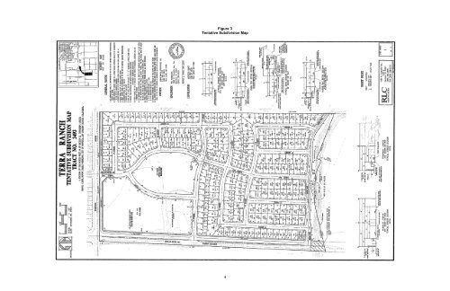
Figure 3 Tentative Subdivision Map 4
NOP Comment Period: Written comments should be submitted at the earliest possible date, but not later than 5:00 p.m. on August 19, 2010 to the following address: Mandy Kang, Assistant Planner, <strong>City</strong> <strong>of</strong> <strong>Manteca</strong> Community Development Department, 1001 West Center Street, <strong>Manteca</strong>, CA 95337. 1.0 PROJECT DESCRIPTION Project Location and Setting The proposed project site is located at 3504 Woodward Avenue in the southwest portion <strong>of</strong> the <strong>City</strong> <strong>of</strong> <strong>Manteca</strong> (See Figure 1, Regional Location). The site is located south <strong>of</strong> Woodward Avenue and west <strong>of</strong> Airport Way (See Figure 2, Project Location) directly south <strong>of</strong> the Dutra Estates Subdivision, which is an existing single-family residential development. The approximately 74.5-acre project site is identified by Assessor’s Parcel Numbers (APNs) 241-320-55 and -56. The proposed project site is relatively flat and does not have any extraordinary topographic features. One approximately 60-year-old single-family home exists on-site. The project site has been used for agricultural purposes, such as row crops, in the recent past. A raised farm complex is centrally located along the western portion <strong>of</strong> the site. Located in the western portion <strong>of</strong> the complex are an unoccupied mobile home, a truck-trailer, three metal storage boxes, a metal shed, and an unoccupied animal pen. Large pole-barns are located in the central portion <strong>of</strong> the complex, and a house, detached garage, domestic well, two metal storage boxes, and three animal pens are located in the eastern portion <strong>of</strong> the complex. In addition, an irrigation well, a water pump, and a diesel engine are located in the central eastern portion <strong>of</strong> the site. Irrigation drainage ditches, standpipes, and PVC piping, as well as an aboveground storage tank (AST) are located on-site. Unpaved farm roads run along the eastern and western site boundaries. Surrounding Land Uses Residential subdivisions are located to the north and northeast <strong>of</strong> the project site, and agricultural land is located adjacent to the east, west, and south <strong>of</strong> the project site. The project site for the Machado Ranch subdivision is located directly adjacent to the eastern portion <strong>of</strong> the project site. It should be noted that the EIR for the Machado Ranch subdivision has been certified but the remaining entitlements have not yet been approved by the <strong>City</strong>. In addition, an existing dry levee is located to the south <strong>of</strong> the project site, and portions <strong>of</strong> the levee are located on-site. Project Components The layout <strong>of</strong> the proposed project would be consistent with a standard single-family residential subdivision. A proposed 5.5-acre park, which would also be utilized as a stormwater detention basin for the project, would be located in the center <strong>of</strong> the project site. The proposed 209 single-family residential homes would surround the park. The 209 single-family lots would range from 6,420 square feet to 13,100 square feet. A 200-unit apartment complex would be located at the northwest corner <strong>of</strong> the project site. In addition, the project would include a 2.8-acre green belt/park in the southern portion <strong>of</strong> the project site adjacent to the aforementioned dry levee. Project infrastructure would include roadways; pedestrian, bicycle and transit facilities; and wastewater, water, and storm drain systems. Infrastructure The primary infrastructure systems installed as part <strong>of</strong> the proposed project would be sized to meet demands created by the proposed project. The proposed project infrastructure includes roadways, pedestrian, bicycle and transit facilities, and wastewater, water, and storm drain systems. Roadways The project includes development and continuation <strong>of</strong> the McKinley Avenue Expressway along the western boundary <strong>of</strong> the project site. The entire four-lane roadway would be constructed as part <strong>of</strong> the 5