Effects of Future Infrastructure Development on Threat Status and ...
Effects of Future Infrastructure Development on Threat Status and ...
Effects of Future Infrastructure Development on Threat Status and ...

Create successful ePaper yourself
Turn your PDF publications into a flip-book with our unique Google optimized e-Paper software.
Vale et al. 3<br />
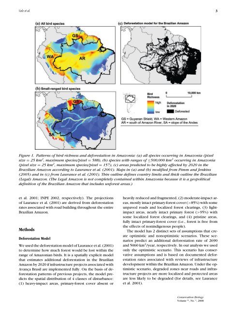
Figure 1. Patterns <str<strong>on</strong>g>of</str<strong>on</strong>g> bird richness <strong>and</strong> deforestati<strong>on</strong> in Amaz<strong>on</strong>ia: (a) all species occurring in Amaz<strong>on</strong>ia (pixel<br />
size = 25 km 2 , maximum species/pixel = 588), (b) species with ranges <str<strong>on</strong>g>of</str<strong>on</strong>g> ≤500,000 km 2 occurring in Amaz<strong>on</strong>ia<br />
(pixel size = 25 km 2 , maximum species/pixel = 157), (c) areas predicted to be highly affected by 2020 in the<br />
Brazilian Amaz<strong>on</strong> according to Laurance et al. (2001). Maps in (a) <strong>and</strong> (b) modified from Pimm <strong>and</strong> Jenkins<br />
(2005) <strong>and</strong> in (c) from Laurance et al. (2001). Thin outline defines country limits <strong>and</strong> thick outline the Brazilian<br />
(Legal) Amaz<strong>on</strong>. (The Legal Amaz<strong>on</strong> is not completely c<strong>on</strong>tained within Amaz<strong>on</strong>ia because it is a geopolitical<br />
definiti<strong>on</strong> <str<strong>on</strong>g>of</str<strong>on</strong>g> the Brazilian Amaz<strong>on</strong> that includes unforest areas.)<br />
et al. 2001; INPE 2002, respectively). The projecti<strong>on</strong>s<br />
<str<strong>on</strong>g>of</str<strong>on</strong>g> Laurance et al. (2001) are derived from deforestati<strong>on</strong><br />
rates associated with road building throughout the entire<br />
Brazilian Amaz<strong>on</strong>.<br />
Methods<br />
Deforestati<strong>on</strong> Model<br />
We used the deforestati<strong>on</strong> model <str<strong>on</strong>g>of</str<strong>on</strong>g> Laurance et al. (2001)<br />
to determine how much forest would be lost within the<br />
range <str<strong>on</strong>g>of</str<strong>on</strong>g> Amaz<strong>on</strong>ian birds. It is a spatially explicit model<br />
that estimates additi<strong>on</strong>al deforestati<strong>on</strong> in the Brazilian<br />
Amaz<strong>on</strong> by 2020 if infrastructure projects associated with<br />
Avança Brasil are implemented fully. On the basis <str<strong>on</strong>g>of</str<strong>on</strong>g> deforestati<strong>on</strong><br />
patterns <str<strong>on</strong>g>of</str<strong>on</strong>g> previous projects, the model predicts<br />
the spatial distributi<strong>on</strong> <str<strong>on</strong>g>of</str<strong>on</strong>g> 4 classes <str<strong>on</strong>g>of</str<strong>on</strong>g> disturbance:<br />
(1) heavy-impact areas, primary-forest cover absent or<br />
heavily reduced <strong>and</strong> fragmented, (2) moderate-impact areas,<br />
mostly intact primary-forest cover (>85%) with some<br />
unpaved roads <strong>and</strong> localized forest clearings, (3) lightimpact<br />
areas, nearly intact primary forest (>95%) with<br />
some localized forest clearings, <strong>and</strong> (4) pristine areas,<br />
fully intact primary-forest cover (i.e., forest is free from<br />
the effects <str<strong>on</strong>g>of</str<strong>on</strong>g> n<strong>on</strong>indigenous people).<br />
The model has 2 distinct sets <str<strong>on</strong>g>of</str<strong>on</strong>g> assumpti<strong>on</strong>s that create<br />
optimistic <strong>and</strong> n<strong>on</strong>optimistic scenarios. These scenarios<br />
predict an additi<strong>on</strong>al deforestati<strong>on</strong> rate <str<strong>on</strong>g>of</str<strong>on</strong>g> 2690<br />
<strong>and</strong> 5060 km 2 /year, respectively. In our analysis we used<br />
<strong>on</strong>ly the optimistic scenario. This scenario has c<strong>on</strong>servative<br />
assumpti<strong>on</strong>s <strong>and</strong> is based <strong>on</strong> documented deforestati<strong>on</strong><br />
rates associated with reviews <str<strong>on</strong>g>of</str<strong>on</strong>g> infrastructure<br />
development within the Brazilian Amaz<strong>on</strong>. Under the optimistic<br />
scenario, degraded z<strong>on</strong>es near roads <strong>and</strong> infrastructure<br />
projects are more localized <strong>and</strong> protected areas<br />
are less likely to be degraded (for details, see Laurance<br />
et al. 2001).<br />
C<strong>on</strong>servati<strong>on</strong> Biology<br />
Volume **, No. *, 2008